85 F. high in the Twin Cities Saturday.
81 F. average high on June 21.
82 F. high on June 21, 2013.
June 21 in Minnesota Weather History: Source: NOAA
1988: The sky was smoky across much of Minnesota due to wild fires during the ’88 drought.
1919: 2nd most deadly tornado in Minnesota history hits Fergus Falls. 59 people died. Like the #1 killer tornado for Minnesota (St. Cloud), it struck on a weekend.
1917: Downpour at Grand Meadow. 4.98 inches fell in just less than a day. Corn crops were badly damaged by the water.

“..In a future with more severe storms, deeper droughts, longer fire seasons and rising seas that imperil coastal cities, public funding to pay for adaptations and disaster relief will add significantly to our fiscal deficit and threaten our long-term economic security. So it is perverse that those who want limited government and rail against bailouts would put the economy at risk by ignoring climate change…”
– Henry Paulson Jr, former Treasury Secretary (2006-2009) in an Op-Ed at the New York Times below.
Weather 2.0
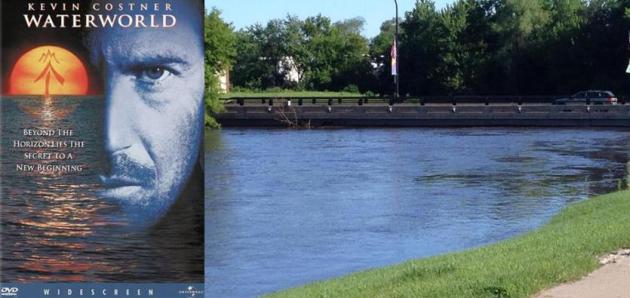
Some might call it job security, but it’s getting to the point where I’m afraid to come to work and check the maps. From Polar Vortex to Waterworld, The Sequel. If Kevin Costner comes sloshing up to my door I’m putting my house on the market. What’s next?
Another day, another sluggish, limping frontal boundary, igniting a new tropical treadmill of T-storms. Check. More red blobs on Doppler, capable of pushing us over the June 1874 rainfall record of 11.67 inches by Friday?
Yep.
And if my sons are reading this, no, your old man doesn’t remember June, 1874. Note quite.
But some days I do feel like the proverbial canary in the coal mine. Are other meteorologists seeing what’s happening? Am I just imagining slower jet stream winds? Upper level steering currents are sluggish and erratic, more prone to odd dips and detours that prolong the cold or the rain or whatever weather-weirdness comes next.
Growing up weather systems moved with consistent regularity. Storms and fronts still stalled, but not nearly as often. This feels different.
An inch of rain may fall from today’s slow-motion frontal passage; another sluggish warm front sparks more downpours late week.
Me? I’m going fishing – in my basement, then feeding the mosquitoes.
Good luck out there.
* photo from Delano courtesy of Craig Mizzoute and Twitter.
1.03″ additional rain predicted by Monday morning in the Twin Cities (00z NAM model).
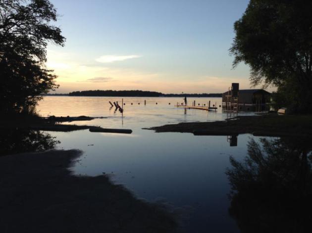
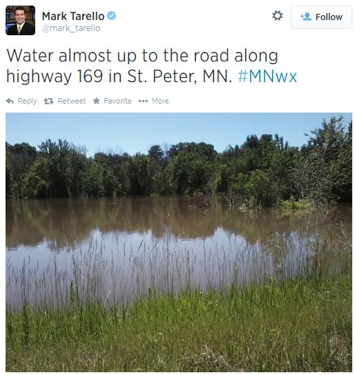
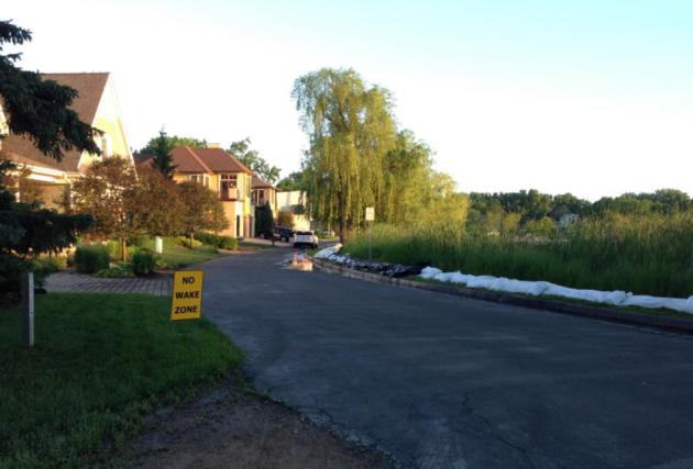
No Swimming In The Parking Lot Please. I snapped this photo from the (flooded) parking lot of a swimming beach on Lake Minnetonka yesterday. More lake – less beach.
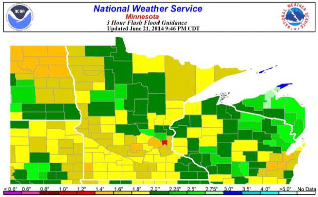
Flash Flood Guidance. According to NOAA models just an inch of rain over a 3-hour period would be enough to trigger flash flooding in Ramsey county, closer to 1.4″ in Hennepin county and 1.6″ in Goodhue county. Stating the obvious: soils are saturated, waterlogged – it won’t take much additional rain for flooding problems to worsen, especially central and southern Minnesota.
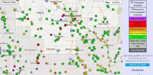
Moderate To Major Flooding. Is it really late June? Because this flood update map courtesy of NOAA’s River Flood Forecast Center in Chanhassen looks like something out of April. Click here for the latest crest forecasts for area rivers.
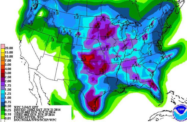
Make. It. Stop. 7-day rainfall guidance from NOAA suggests another 2-3″ rain from the eastern Dakotas and Minnesota into western Wisconsin and northern Iowa. More downpours are likely from Kansas to Texas. Our atmospheric holding pattern will hold a little while longer.
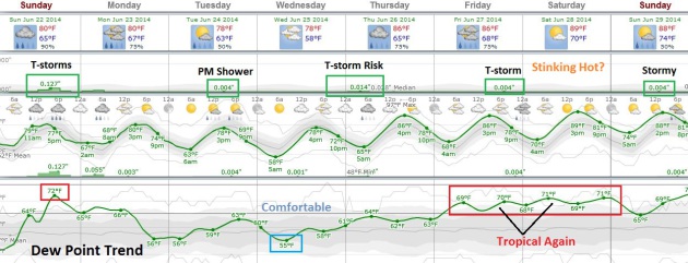
Not Much Relief. From the storms or the humidity. Today’s sluggish cool frontal passage sparks heavy T-storms; a reinforcing push of Canadian air sparks a few PM showers and T-showers Tuesday, followed by relatively comfortable air Wednesday with dew points in the 50s. But hot air comes charging north again the latter half of the week, igniting more T-storms Wednesday nignt into Thursday. By Saturday highs may be approaching 90F.


TODAY: Muggy, heavy T-storms likely. Winds: SW 8. High: 82
SUNDAY NIGHT: Lingering T-storms, locally heavy rain possible. Low: 66
MONDAY: Unsettled, stray shower or T-shower – but not as wet. High: 81
TUESDAY: Sunny start, few PM showers? Wake-up: 62. High: 79
WEDNESDAY: Some sun, nighttime T-storms. Wake-up: 59. High: 78
THURSDAY: Warm & sticky; spotty T-storms. Wake-up: 64. High: 84
FRIDAY: Hot sun, late-day pop-up storm. Wake-up: 68. High: 86
SATURDAY: Sweaty sunshine, lake-worthy. Dew point: 70. Wake-up: 70. High: near 90
* photo above: residents of Tonka Bay, near Excelsior on Lake Minnetonka were sandbagging yesterday, in response to the highest lake water levels ever observed.
Climate Stories…

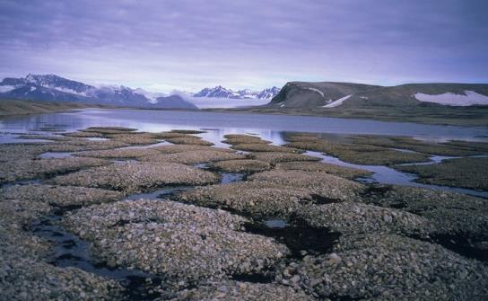
Siberian Global Warming Meets Lukewarm Reaction in Russia. Inter Press Service has the story – here’s an excerpt: “People in Siberia must prepare to face frequent repeats of recent devastating floods as well as other natural disasters, scientists and ecologists are warning, amid growing evidence of the effects of global warming on one of the world’s most ecologically diverse regions. More than 50,000 people were affected by floods in the Altai region and Khakassia and Altai republics in southern Siberia at the end of May and early June. These came just over half a year since the worst floods in Siberia in living memory. But while floods caused by snowmelt are not uncommon to Siberia, these most recent ones were caused by excessive rainfall – a phenomenon global warming is expected to make much more frequent in future…”
Photo credit above: “Climate change will cause the Siberian permafrost to thaw.” Credit: Softpedia/Celsias.
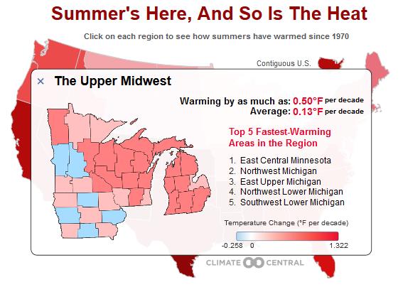
Summertime Blues. U.S. Seeing Red as Temps Rise. The long-term temperature trends, with a few exceptions, are warmer for the vast majority of the United States. Here’s an excerpt from Climate Central: “…The summer solstice is right around the corner this Saturday and temperatures around the U.S. have started to rise to the occasion. But it’s not just a warmup from spring to summer that’s occurring: summer temperatures have been steadily rising since 1970. On average, temperatures have increased at a rate of about 0.4°F per decade in the contiguous U.S. since 1970, or nearly 2°F overall. But some areas have been warming much faster, and others more slowly. The fastest warming “climate divisions,” or localized areas within regions, are in southern California and Nevada in the western region. There, temperatures have risen by as much as 1.32°F per decade, or more than 5°F overall since 1970…”
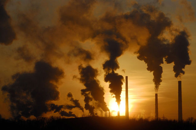
The New Environmentalism Will Lead Us To Disaster. Is there such a thing as a “Good Anthropocene”? Here’s a snippet of an Op-Ed at Scientific American: “…Some climate science deniers believe only God can change the climate; ecopragmatists, by contrast, see humans as “the god species.” Here is what the god species and this kind of thinking are certain to give us: an atmosphere with 500 ppm of CO2 (probably closer to 700 ppm) and a climate that is hot, sticky and chaotic. It will indeed take omnipotence to fix the problem without calamity. For those who prefer orthodox climate science, such unbounded optimism is dangerous, wishful thinking.” (Image credit: NASA).
