57 F. high temperature Monday in the Twin Cities.
49 F. average high on March 30.
60 F. high on March 30, 2014.
March 31, 1896: A strong snowstorm dumps 13.5 inches of snow at Maple Plain. Vivid lightning in storm with 10-12 flashes per minute. Visibility was down to less than one block. The temperature was 57 at Maple Plain the day before.
March 31, 1843: The low temperature at Ft. Snelling plummets to -11. Source: Twin Cities NWS.
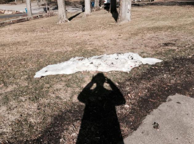
Instant Spring
“In the Spring I have counted 136 different kinds of weather inside of 24 hours” wrote Mark Twain. Yep. I counted 154 but close enough. The transition to spring is a hairy ordeal; chirping birds can quickly give way to blinding blizzards, bubbling rivers and raging tornadoes.
The problem is differential heating. Today the sun is as high in the sky as it was on September 11. The ground, and air immediately above the ground, is warming rapidly, but the upper atmosphere is relatively chilly, suffering from a wintry hangover. Resulting instability can spawn severe thunderstorms; angry red blobs on Doppler that sprout suddenly.
Although low level moisture is limited and dew points are still quite low there’s a chance southern Minnesota may experience the first severe storms of spring Wednesday evening.
The mercury tops 60F today and 70s are likely tomorrow before a conga-line of cumulonimbus clouds kick up strong winds and small hail. At least it’s not snow.
We cool off into the 40s by late week, allowing you to wear sweatshirts and shorts. Nothing wrong with that.
On the blog below: a super-sized El Nino in 2015 and hints of a wetter pattern by mid-April. We’re due for rain.
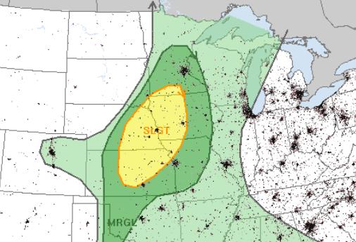
Wednesday Severe Potential. Here’s a sign of the times. NOAA SPC has a slight risk of severe storms from near Wichita and Kansas City to Omaha, Des Moines and far southern Minnesota Wednesday afternoon and evening, a roughly 15% chance of severe weather (1″+ hail, winds over 58 mph) within 25 miles of any point in the yellow-shaded area.
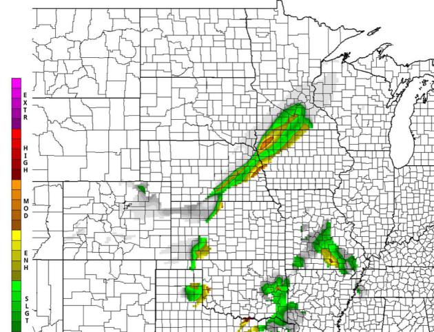
TPI: Tornado Potential Index. The map above is valid 7 PM Wednesday, showing an enhanced risk of severe storms south and west of Mankato with a greater risk from near Sioux City to Omaha. I suspect the atmosphere will be too dry and stable for tornadoes in Minnesota, but small hail and gusty winds are possible, especially south of the Minnesota River. Map: HAMweather.
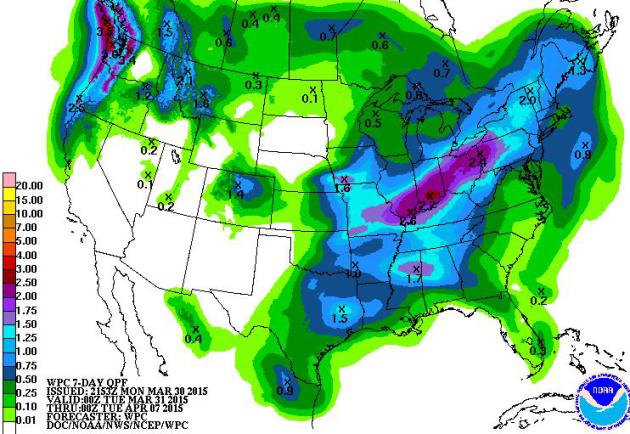
A Parade of New-Misses. As has been the case for the better part of 9 months, big storms continue to detour south and east of Minnesota for the next 7 days; some 2-3″ rainfall amounts predicted across the Ohio Valley and Pacific Northwest. Map: NOAA.
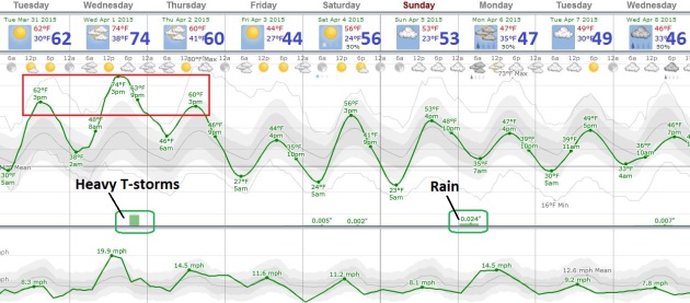
Springy Interlude. 60s will feel good today; 70s tomorrow capable of sparking a sudden rush of adrenaline and dopamine capable of extreme distraction and apathy. We start to cool off Thursday; light jackets return Friday before temperatures recover a little over the weekend. More rain falls late Sunday into Monday, but the brunt of the moisture pinwheels south and east of Minnesota. Graphic: Weatherspark.
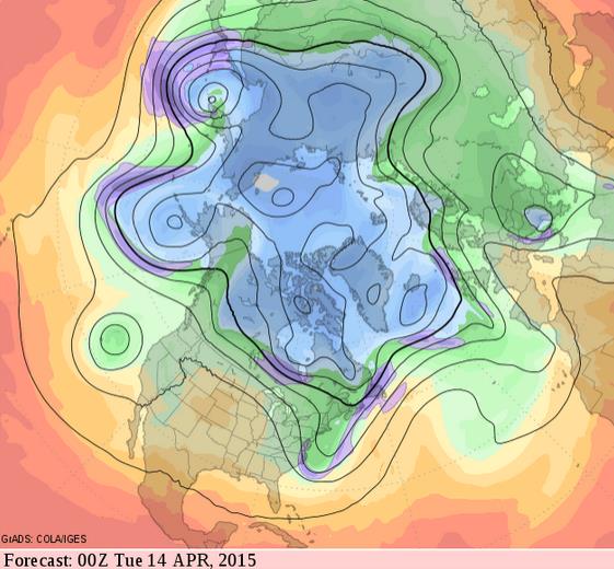
So Long Winter. Long range guidance (500 mb winds) show a tendency for cold troughs of low pressure over New England and the Pacific Northwest the next 2 weeks as the core of the jet stream lifts north, allowing warmer air to push across the Plains into the Upper Midwest. We’ll see more chilly relapses, but I don’t see snow or anything bitter looking out into mid-April. GFS guidance: GrADS:COLA/IGES.
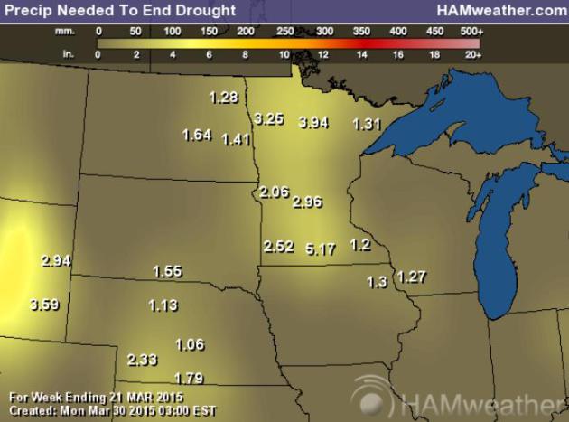
Moderate Drought. As much as 2-5″ of rain is required to pull out of a deepening drought. At last report over 88% of Minnesota was in moderate drought; 99% of the state abnormally dry. Source: NOAA and HAMweather.
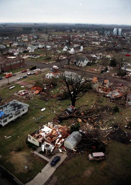
17 Years After The Comfrey, St. Peter Tornado. I remember it well, and so do many residents of southern Minnesota: March 29, 1998. Here’s an excerpt of a quick recap from KEYC in Mankato: “Seventeen years ago southern Minnesota saw one of the worst tornado outbreaks, as 14 twisters including six categorized as F2’s, moved through Comfrey, St. Peter, and Le Center. One tornado traveled 67 miles on the ground, the fifth longest track in Minnesota history, passing through five counties. That cyclone passed directly through the city of St. Peter, damaging more than 90 percent of the homes and businesses. The storm claimed two lives, and the city sustained between 300 and 500 million dollars worth of damage…”
File photo credit: Storm damage from Comfrey, Minnesota, taken March 30, 1998.
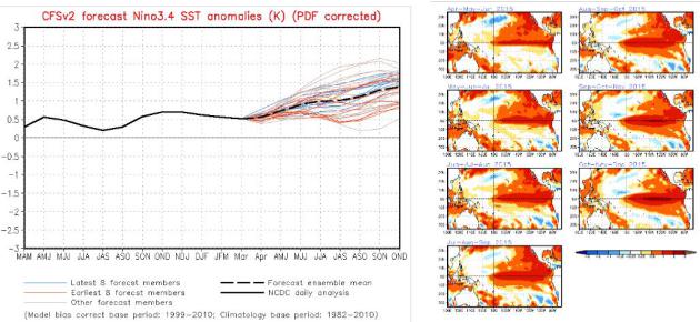
More Significant El Nino Brewing. Every update from NOAA CPC looks more impressive for scope and duration of warming from a warm phase in the Pacific Ocean. Latest forecasts suggest sea surface temperature anomalies as much as 1-2F warmer than average by the winter months.
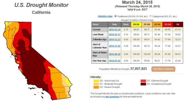
California Drought Goes From Bad to Worse As State Grapples With Heat Wave. The Guardian has details; here’s a clip: “…Experts say the scorching spring days are part of a long-term warming pattern – driven largely by human activity – that is increasing the chances that future droughts will be as bad as this one. At fault is a warm and dry weather combination, which exacerbates the already dire drought conditions by drying soil, melting snow and driving up water usage. “It’s like a one-two punch,” said Jeanine Jones, deputy drought manager for the state Department of Water Resources (DWR). “Not having enough water to fill our reservoirs and having the hot weather evaporate the little that we do have…”
* Latest U.S. Drought Monitor for California is here.
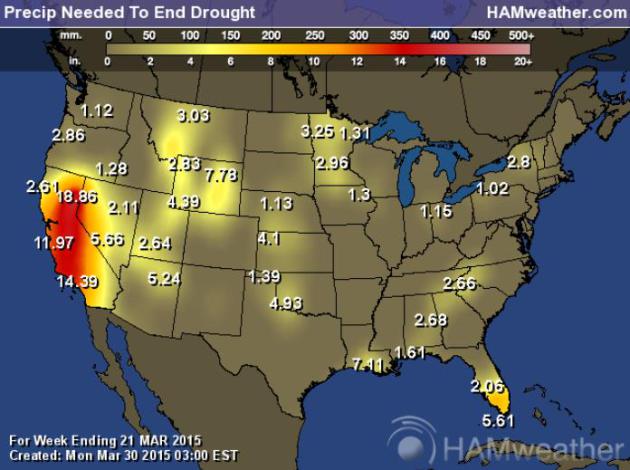
National Numbers. 1 to 2 feet of rain is required in the short term to pull much of California out of extreme drought. If the mega-drought persists another 2-3 years it’s not inconceivable that major cities could experience severe water shortages.
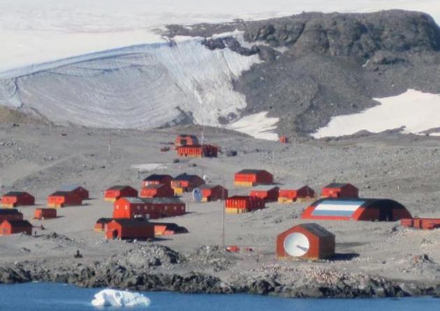
Possible New Continental Heat Record for Antarctica. Christopher Burt has the story at Weather Underground; here’s an excerpt and link: “On March 24th Base Esperanza (under Argentinean administration) located near the northern tip of the Antarctic Peninsula reported a temperature of 17.5°C (63.5°F). Although this is the warmest temperature ever measured since weather stations became established on the southern continent, it is complicated by what the very definition of ‘Antarctica’ is. Here’s a brief review…”
Image credit: “Argentina’s Esperanza Base on the northern tip of the Antarctic Peninsula. It is located near 63°S latitude.” Image from Wikipedia.
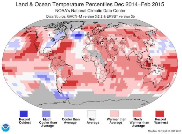
A Hypothesis About The Cold Winter In Eastern North America. Could a slow-down in the North Atlantic circulation, triggered by rapid melting of (fresh) water from Greenland be responsible for the jet stream dips that have brought unusually cold weather to the eastern USA the past few winters, while the rest of the northern hemisphere experienced unusual warmth? Here’s an excerpt of a post at Real Climate: “The past winter was globally the warmest on record. At the same time it set a new cold record in the subpolar North Atlantic – and it was very cold in the eastern parts of North America. Are these things related? Two weeks ago NOAA published the following map of temperature anomalies for the past December-January-February (i.e. the Northern Hemisphere winter). One week ago, we published a paper in Nature Climate Change (which had been in the works for a few years) arguing that the cold in the subpolar North Atlantic is indicative of an AMOC slowdown…” (Image credit above: NOAA).
Two weeks ago NOAA published the following map of temperature anomalies for the past December-January-February (i.e. the Northern Hemisphere winter). One week ago, we published a paper in Nature Climate Change (which had been in the works for a few years) arguing that the cold in the subpolar North Atlantic is indicative of an AMOC slowdown (as discussed in my last post).
– See more at: http://www.realclimate.org/index.php/archives/2015/03/a-hypothesis-about-the-cold-winter-in-eastern-north-america/#sthash.LPZr0qKX.dpuf
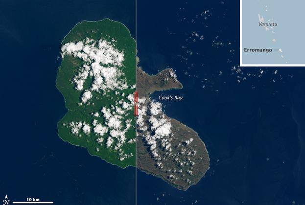
Satellites Show Vanuatu’s Scars From Cyclone Pam. Here’s a snippet from Climate Central: “…An analysis of satellite and modeled data show that Pam was a Category 5 storm, with sustained winds in excess of 157 mph. The island of Erromango bore the brunt of Pam’s fury with wind gusts estimated at up to 200 mph according to Capital Weather Gang. Tanna — an island to the south of Erromango — fared only slightly better, with 160 mph wind gusts at their peak, though they still managed to damage or destroy an estimated 80 percent of the structures on the island that’s home to 30,000. Landsat imagery reveal the stark changes Pam has wrought on the islands’ formerly green hillsides. In particular, windward sides of the islands have been turned to a dingy brown as foliage was ripped off trees and large swaths of forests were overturned…”
Image credit above: “Before and after images of Erromango.” Credit: NASA Earth Observatory

The Science Of Why You Should Spend Your Money on Experiences, Not Things. Co.EXIST manages to successfully summarize why the thrill of material possessions only lasts so long, unlike a great vacation, which you can be talking about for a lifetime: “…There’s a very logical assumption that most people make when spending their money: that because a physical object will last longer, it will make us happier for a longer time than a one-off experience like a concert or vacation. According to recent research, it turns out that assumption is completely wrong. “One of the enemies of happiness is adaptation,” says Dr. Thomas Gilovich, a psychology professor at Cornell University who has been studying the question of money and happiness for over two decades…”

Daily Apple Not Associated With Reduced Doctor Use. Fewer medications and prescriptions, yes. Here’s a clip from a story at The Atlantic: “In an unsettling finding, the medical journal JAMA Internal Medicine reports this morning that although daily apple eaters are less likely to use prescription medications, “Evidence does not support that an apple a day keeps the doctor away….”

The Secret History of Caffeine. What would we do without our morning jolt of coffee? Perish the thought. Here’s an excerpt of a very informative article at Salon: “…The boost we feel from coffee comes less from what caffeine does to the brain than from what it prevents. Experts call caffeine an “antagonist” because it interferes with the natural function of certain brain chemicals, particularly one called adenosine. Researchers still don’t know all the things adenosine does in the brain, but there’s a way to explain its basic role that will be familiar to millions of radio listeners…”
TODAY: Lot’s of sun, beautiful. Winds: NW 5-10. High: 62
TUESDAY NIGHT: Partly cloudy and relatively mild for late March. Low: 45
WEDNESDAY: Lukewarm sun much of the day, severe storms late? High: 74
THURSDAY: Mix of clouds and sun, cooler. Wake-up: 48. High: 61
FRIDAY: Intervals of sun, brisk. Wake-up: 32. High: 46
SATURDAY: Mostly cloudy, few sprinkles possible. Wake-up: 31. High: 49
SUNDAY: More clouds than sun, breezy. Wake-up: 37. High: 56
MONDAY: Rain, few T-storms possible. Wake-up: 35. High: 47
Climate Stories….

Before And After Glacier Photos Show Devastating Climate Change Effects. Glaciers react to longer term swings in temperature trends – the vast majority of the world’s glaciers continue to melt and Alaska is ground zero. Here’s an excerpt of a story at weather.com: “In the past 50 years, Alaska’s average annual temperature has increased at a rate more than twice that of the rest of the United States. Temperatures at Alaska’s Glacier Bay National Park and Preserve are now 5 degrees warmer than previous averages, Glacier Bay’s website reports. The warming climate has a major effect on the park’s famous glaciers. There are more than 100,000 glaciers in Alaksa, and 95 percent of them are thinning, stagnating or retreating. Muir Glacier in Glacier Bay National Park thinned more than 700 feet in the 23 years between 1980 and 2003...”
Photo credit upper left: “A photo taken from the Muir Inlet in Glacier Bay National Park and Preserve, Alaska between the 1880s and 1890s, shows the 328-foot-high terminus of the glacier and numerous icebergs, some more than 6 feet in diameter.” (Glacier Bay National Park and Preserve Archive).
Photo credit upper right: “A northwest looking photograph taken from the same location in 2005 shows that the Muir Glacier has retreated more than 31 miles and is completely out of the field of view. The glacier in the background to the right is Riggs Glacier. Abundant vegetation is visible.” (Bruce F. Molnia/USGS)

Ted Cruz Embodies Republican Climate Change Dilemma. The Guardian has the story – here’s an excerpt: “…Leading scientists are preparing for an American election in which global warming may receive much higher billing than before – and Republicans’ statements will be exposed to a level of scrutiny they have not formally had to deal with. Cruz, the red-meat Texas senator with an army of conservative followers, raised eyebrows on Tuesday when he told the Texas Tribune that people who believe global warming is real are “the equivalent of the flat-Earthers”…
Republicans Are Attacking Climate Change Science By Comparing It To Religion. New Republic has the article – here’s an excerpt: “…Republicans, even Graham, who compare climate change to a religion typically do so to push back on Obama’s executive action limiting carbon pollution. What better way to make Obama look extremist than claim he is being motivated by a religious fervor for environmentalism? The climate-as-a-religion accusation is hardly a new invention. It continues to cycle in and out of political rhetoric...”

Rockefeller Family Tried And Failed To Get ExxonMobil To Accept Climate Change. Here’s an excerpt of a sobering read, courtesy of The Guardian: “…The family retains only a tiny fraction of shares in Exxon. But the stand taken by the Rockefellers – at a time when Exxon was under attack from campaign groups for its support of climate denial – rankled company executives who had expected family members to be allies, Goodwin said. “They were shocked to find this family that had a strong link with them, and that they expect to find a great friend and admirer … had such a negative view.” But even with the weight of that historical connection Exxon was still not persuaded to change…”


