37 F. high temperature yesterday in the Twin Cities.
36 F. average high on November 24.
46 F. high on November 24, 2015.
November 25, 1977: Record lows are set across central Minnesota with lows in the teens below zero. Montevideo had the coldest temperature of 18 degrees below zero along with Long Prairie at 16 degrees below zero.
November 25, 1820: Ft. Snelling is in the middle of a three-day blizzard that would dump nine inches of snow.
Shopping For A Warmer Front – A Numbing December?
Shopping: The fine art of acquiring things you don’t need with money you don’t have. The older I get the more I appreciate the ultimate gift: time.
“The only gift is a portion of thyself” quipped Ralph Waldo Emerson.
Don’t buy me stuff that will wind up a flea market or landfill. Spend some time – make memories with me instead.
No problems navigating to your favorite stores today. Expect dry roads with peeks of sun and upper 30s. Now that it’s winter our definition of “warm front” has morphed. 40s will feel like sweet relief tomorrow. Clouds thicken on Sunday with a cold rain Sunday night; showery rains spilling into Monday as colder air returns on gusty winds.
A persistent swirl of unusually cold air aloft will wring out flurries and snow showers next week; I could see a coating to an inch or two next Tuesday and Wednesday. But big storms capable of significant travel disruptions should pass south and east of Minnesota the next 2 weeks.
The more I stare at the maps the colder they appear. A taste of January in December? Yep. I’m predicting a very white Christmas this year.
Preparing Your Winter Uniform. Yes, I know everyone knows how to dress for the cold, but I thought this NOAA graphic was pretty cool. Remember, no such thing as bad weather – just inappropriate clothing choices.
Winter Weather Accident Statistics. For me the most important lesson in all of this is to force myself to slow down. Many of us still drive way too fast for conditions. Here’s an excerpt from thezebra.com: “According to the Federal Highway Administration, 70 percent of the nation’s roads are located in snowy regions—in other words, anywhere that receives more than five inches of snowfall each year, on average. In addition, nearly 70 percent of the U.S. population lives in these snowy regions. In other words? A lot of us have to deal with winter storms. And about 70 percent of the accidental deaths that occur in the wintertime happen in automobiles.
Other Sobering Stats (from the folks at SafeWinterRoads.org:
- Over 1,300 people are killed and more than 116,800 people are injured in vehicle crashes on snowy, slushy or icy pavement annually.
- Every year, nearly 900 people are killed and nearly 76,000 people are injured in vehicle crashes during snowfall or sleet…”

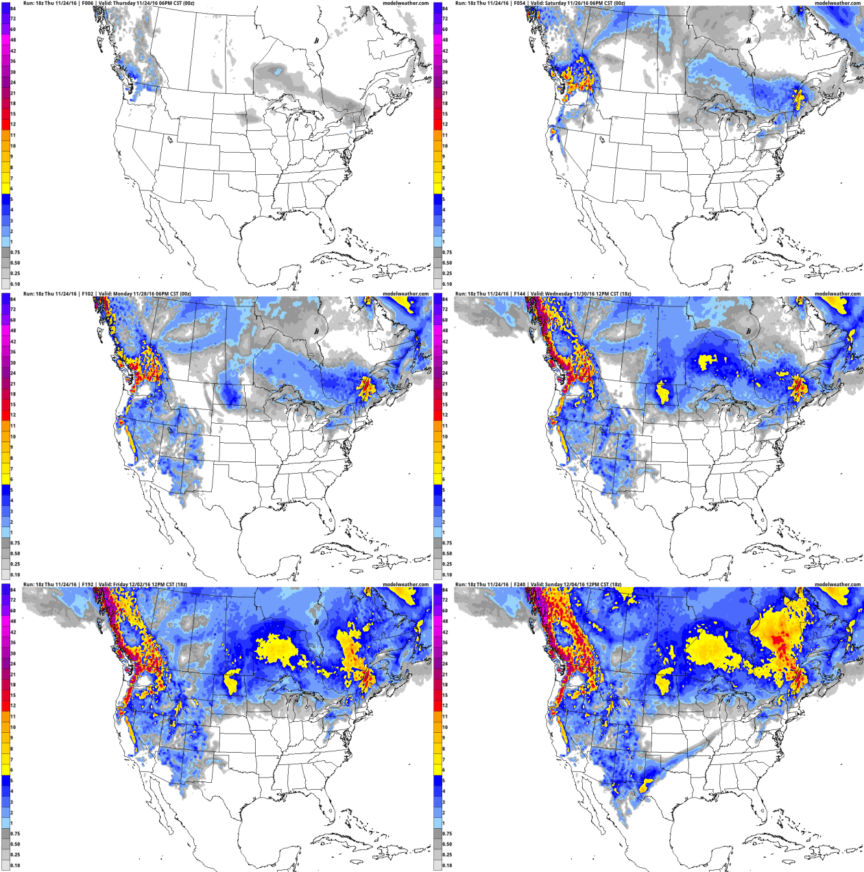
10-Day Snowfall Potential. This is the accumulated snowfall product from NOAA’s GFS model, showing a few inches for upstate New York, northern New England and the Upper Midwest; maybe a plowable accumulation for North Dakota – extreme snowfall amounts for western mountains and the Pacific Northwest. Loop: AerisWeather.
Getting Home Weather. ECMWF (European) guidance shows rain spreading across the Plains into Kansas City, Omaha and Des Moines Sunday afternoon; generally dry weather east of the Mississippi with a numbing breeze for New England. Showers may spread into Seattle and Portland as the day goes on Sunday. All things considered it could be (much) worse. 18z Sunday data: WSI.
New Definition Of “Warm Front”. More like a not-as-cold-front as temperatures rise into the 40s over the weekend before chilling back down below average by the latter half of next week. ECMWF data for KMSP: WeatherBell.
November Nuggets. Here are a few factoids regarding the abnormally mild start to November across the USA, courtesy of Planalytics: “Nationally, it was the warmest 3rd week of November in 55+ years. Cooler temperatures were focused in the South Atlantic region. Despite the late week snowstorm, the third week of November recorded the least snow and rain since 2012…”
Record Dry Streak for Atlanta. The Atlanta office of the National Weather Service created the graphic above. Yesterday was the 39th day in a row without a drop of rain at ATL, tying the record set in 1884.

NASA Set To Launch New Fleet of Hurricane-Tracking Small Satellites. A constellation of low-orbit satellites, it turns out. Here’s an excerpt from hutchnews.com: “NASA is set to launch its first Earth science small satellite constellation, which will help improve hurricane intensity, track, and storm surge forecasts, on Dec. 12 from Cape Canaveral Air Force Station in Florida. The Cyclone Global Navigation Satellite System (CYGNSS) hurricane mission will measure previously unknown details crucial to accurately understanding the formation and intensity of tropical cyclones and hurricanes. “This is a first-of-its-kind mission,” said Thomas Zurbuchen, associate administrator for NASA’s Science Mission Directorate at the agency’s headquarters in Washington. “As a constellation of eight spacecraft, CYGNSS will do what a single craft can’t in terms of measuring surface wind speeds inside hurricanes and tropical cyclones at high time-resolution, to improve our ability to understand and predict how these deadly storms develop…”
Image credit: NASA. “The primary science goal of Cyclone Globe Navigation Satellite System (CYGNSS) is to better understand how and why winds in a hurricane intensify. CYGNSS is a unique satellite mission that consists of a constellation of 8 small satellites.”
Improving Hurricane Intensity Forecasts. Launch is set for December 12. Here’s more detail and clarity on what the mission entails from NASA: “Hurricane track forecast accuracy has improved since 1990, but there has been little improvement in intensity forecast accuracy. A new NASA mission using eight micro-satellites will make accurate measurements of ocean surface winds in and near the eye of the storm throughout the lifecycle of tropical cyclones, typhoons & hurricanes. The Cyclone Global Navigation Satellite System (CYGNSS) will probe the inner core of hurricanes to learn about their rapid intensification. The mission will launch from Cape Canaveral Air Force Station, Florida, on a Pegasus XL rocket. The University of Michigan is developing CYGNSS…”
Why Hedging a Forecast Is Sometimes The Best Thing To Do. TV meteorologist Don Paul gets it right at The Buffalo News; the forecast is rarely black and white, and forecasts can do a better job communicating the gray: “…In operational meteorology, we don’t deal with 3 or 4 percentage point spreads between possible forecast solutions and different models’ output. The uncertainty in projecting the behavior of the atmosphere over a small portion of a spinning globe, three-quarters of which is water covered, heated very unevenly by a thermonuclear furnace 93 million miles distant is generally higher than a single digit percentage figure. However, we do have laws of physics and numerous equations to help us juggle the interactions. And we have powerful computer models and ensembles of those models to give us a range of solutions we can hopefully narrow down with continuing education, analysis, pattern recognition and a base of experience...” (File image: University of Wisconsin CIMSS)
Russian Scientists May Have Found Geological Evidence of “Noah’s Flood”. I’m skeptical, but who knows – maybe it’s real? Here’s an excerpt from Nature World News: “…The Kola Borehole is a very lengthy drill hole, where samples of soil as deep as 12 kilometers into the earth’s crust have been collected. According to experts, the soil will become denser as the drill goes deeper into the earth; however, they found interesting evidence that may change what we all have believed in...”
Hot Tech Gifts. The New York Times highlights a few gift ideas for the techno-geek in your life: “It is often daunting to sort through the newest technology products to find something fitting for your gadget-savvy family and friends. Fret not: Here are some of the most useful and entertaining tech gifts of the year...”
“Thanksgiving was never meant to be shut up in a single day.” – Robert Casper Lintner
BLACK FRIDAY: Mostly cloudy, dry. Winds: W 5-10. High: 37
FRIDAY NIGHT: Patchy clouds. Low: 28
SATURDAY: Peeks of sun, a bit milder. Winds: SE 7-12. High: 45
SUNDAY: Clouds increase, rain likely Sunday evening and night. Winds: SE 10-20. Wake-up: 31. High: 47
MONDAY: Showery rains, cooling off. Winds: SW 15-25. Wake-up: 43. High: near 50, then falling
TUESDAY: Coating of wet snow on lawns? Winds: NW 10-15. Wake-up: 34. High: near 40
WEDNESDAY: Light snow, inch or two possible. Winds: NW 10-15. Wake-up: 32. High: 36
THURSDAY: Flurries linger, still raw. Wake-up: 30. High: 35
* Photo credit above: Harrison Jones.
Climate Stories…
2016 Breaking Records In All The Wrong Places. CleanEnergy Footprints has a rundown on some of the most jaw-dropping weather of 2016; events that may have been amplified and magnified by a warmer, wetter climate, according to WMO (World Meteorological Organization): “…Numerous extreme weather events caused catastrophic impacts to people around the world, including Hurricane Matthew and Typhoon Lionrock; major floods in the Yangtze basin, Sri Lanka, and the Niger River basin; extreme heat waves in Southern and Northern Africa and the Middle East; the Alberta wildfire; and Southern African drought. Together these extreme weather events killed at least 1,000 people, destroyed or severely crippled thousands of people’s homes and livelihoods, caused tens of billions of dollars worth of damage, and are expected to contribute to millions of people’s famine and displacement. A separate WMO report released last week showed that of 79 studies about extreme weather events published by the Bulletin of the American Meteorological Society between 2011 and 2014, more than half found that human-induced climate change contributed to the extreme event in question…”
Meteorologist Paul Douglas Hopes To Bridge Christian Climate Change Debate. My thanks to Jean Hopfensperger at The Star Tribune for the review: “The book, entitled “Caring for Creation: An Evangelical’s Guide to Climate Change and a Healthy Environment,” hit the bookstores this month. It is co-authored by the Rev. Mitch Hescox, president of the Evangelical Environmental Network. “I figured if people didn’t want to hear from scientists, maybe they’d listen to a minister and a meteorologist,” said Douglas. The book constructs the debate around evangelical values: It is the “personal responsibility” of Christians to protect God’s creation. It is “pro-life” because it is protecting children from illnesses from autism to asthma, as well as protecting all life on Earth…”
About That “Global Warming Pause”. NASA has an overview into the so-called “hiatus”, pointing out that much of the “missing warmth” was redistributed into the world’s oceans: “…The hiatus period gives scientists an opportunity to understand uncertainties in how climate systems are measured, as well as to fill in the gap in what scientists know,” said Yan. “NASA’s examination of ocean observations has provided its own unique contribution to our knowledge of decadal climate trends and global warming,” said study co-author Veronica Nieves of JPL and the University of California, Los Angeles. “Scientists have more confidence now that Earth’s ocean has continued to warm continuously through time. But the rate of global surface warming can fluctuate due to natural variations in the climate system over periods of a decade or so…”

