14 F. high on Sunday in the Twin Cities.
23 F. average high on January 11.
32 F. high on January 11, 2014.
1/10th of an inch of snow fell at MSP International Airport yesterday.
4″ snow on the ground.
January 11, 2000: Snow falls in a narrow band over the Twin Cities. Maplewood receives 5.5 inches, while Chanhassen gets 12.
January 11, 1888: “Blizzard of ’88.” It hit during a mild day when many children were heading home from school. They made up the majority of the 200 people that died. At the end of the storm the thermometer at St. Paul read -37.

Coping Skills
How do you get through a Minnesota winter? Ask 100 people and you’ll get 100 different opinions, suggestions and tips. Light boxes that mimic the sun and reduce the potential for SAD depression. More vitamin B. Investing in a pair of warm, waterproof boots, extra layers, a space heater, ear muffs AND a hat. MORE SOUP! And a remote-starting kit, so you can start your car while you’re still in the office.
They all help, but perhaps nothing soothes a cruel, cryogenic winter like a southern trip in search of warm sunshine. Anywhere. And I now realize just the thought of a future getaway is almost as good as the trip itself.
Sometimes the warm fronts come to you. After a week of subzero nighttime lows and windchills low enough to close schools and spark Facebook posts from concerned aunts I’m happy to report a streak of 30s Thursday into early next week. Thermometers may nudge 40F Saturday. Dripping icicles and sloppy puddles are 3-4 days away.
We cool off again next week but I still don’t see anything even remotely resembling a “storm”.
Snow lovers: don’t panic yet, but with a brewing El Nino and more southerly storm track the odds of a 70-inch winter like last year are pretty small.
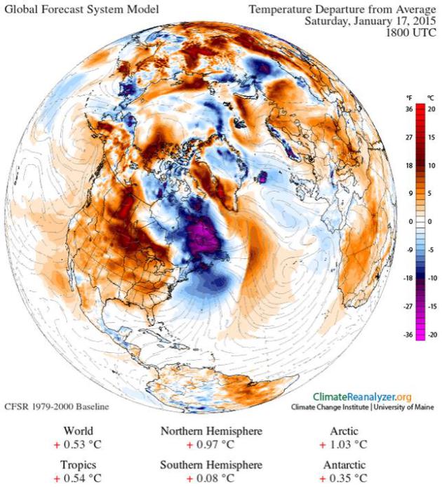
Mellowing Out. Temperature anomalies are 10-15F warmer than average across far southern Minnesota and much of the Upper Midwest by next weekend, in fact most of the USA, from Alaska to Florida, will see a mild bias the next 1-2 weeks.
Image credit above: Temperature forecast above obtained using Climate Reanalyzer (http://cci-reanalyzer.org), Climate Change Institute, University of Maine, USA.
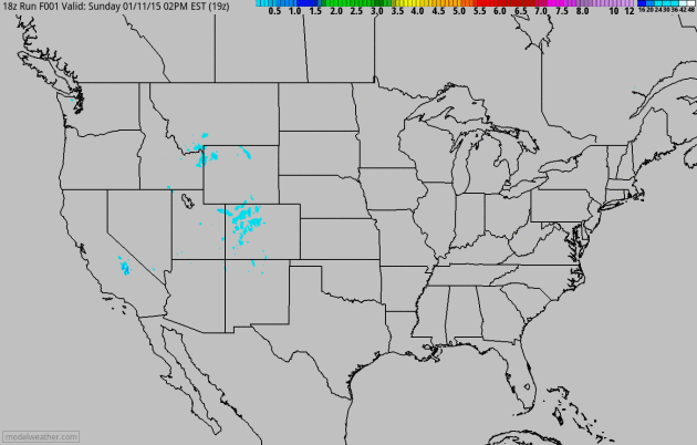
Snowy Streak. Moisture from the Gulf of Mexico surges northward across the Mississippi Valley into the Ohio Valley and northern New England before this disturbance pushes out to sea Tuesday night. Skiers from Deer Valley and Snowbird outside Salt Lake City to Aspen and Breckenridge are looking forward to a few more inches of snow over the next 60 hours. NAM snowfall guidance: NOAA and HAMweather.
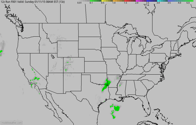
January Soaker. The same surge of southern moisture drops locally heavy rain from Little Rock and Louisville to Washington D.C. – mixed with glaze ice from the Ohio Valley to Baltimore and Philadelphia. Farther south expect rain from Memphis and Atlanta into Florida.
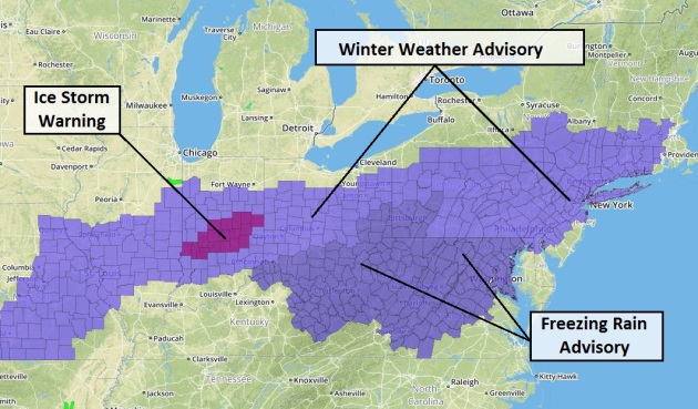
Slipping and Sliding. NOAA has much of the Ohio Valley and Mid Atlantic lit up with advisories. A more serious Ice Storm Warning is posted for the Indianapolis area, where some .25″ accumulations of glaze ice are possible. For the latest advisories, watches and warnings from The National Weather Service click here.
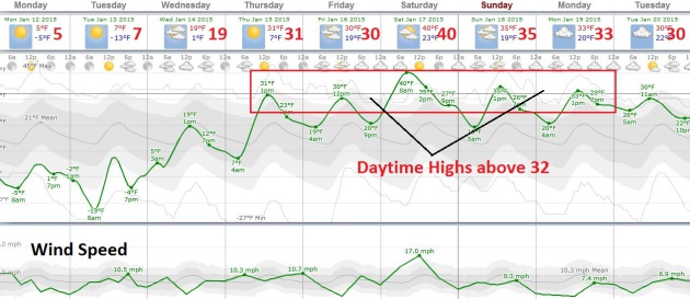
Cheer On The Warmer Front. Today will be cold enough and tomorrow may start off with double-digit negative numbers, but the Pacific breeze predicted for a couple of weeks now is still on track. 30s will feel remarkably good from Thursday into early next week. Daytime highs rise above freezing but nighttime lows dip into the low and mid 20s, slowing some of the snow melt. That said our 5″ snow on the ground may be down to 1-2″ by Tuesday of next week. Source: Weatherspark.


TODAY: The cold is getting old. Bright sun. Feels like -20. High: 5
MONDAY NIGHT: Clear and plenty cold. Low: -10
TUESDAY: Nippy start, fading sunshine by afternoon. High: 10
WEDNESDAY: More clouds, not nearly as numb. Wake-up: 3. High: 20
THURSDAY: Patchy clouds, welcome thaw! Wake-up: 10. High: 32
FRIDAY: Dripping icicles. We earned this. Wake-up: 21. High: 34
SATURDAY: Mild start, clouds build. Wake-up: 24. High: 39
SUNDAY: Still gray, above average temps. Wake-up: 22. High: 35
Climate Change