
A Raw Deal
Nature never moves in a perfectly straight line. We limp, trip and stumble our way into spring – always two steps forward, one step back. Or is it the other way around?
And as much as I’m looking forward to a hot, sweaty summer up at the lake I don’t mind this March flashback. Chilly weather is reducing the threat of severe storms and babysitting the Doppler. It also sets the stage for steady “overrunning” rain tomorrow as warm air rides up and over a persistent wedge of Canadian air camped out above our heads. The entire state needs a good long soaking right about now.
Yesterday’s rain brushed southern Minnesota; a few severe storms near Rochester – a preview of coming attractions. We temporarily dry out today before a slow-moving storm spreads a shield of rain back into the state Thursday; half an inch of rain possible for thirsty farms, lawn & gardens.
Sunshine returns Friday; Saturday should renew your faith in April with highs surging into the 60s. ECMWF guidance is hinting at mid-70s and severe storms in one week.
Yes, this damp, chilly breeze is annoying, but 40s will inoculate us from any serious weather drama the next few days. Let’s just take this one week at a time, OK?
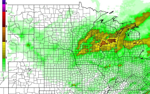
Transitioning Into a Wetter Pattern? It’s still too early to say with a high degree of confidence, but it appears that we may be turning a corner with moisture as storms take a more northerly track with a rising sun angle and expanding warmth. The arrival of 60s and a few 70s next week should be accompanied by heavier showers and T-storms, possibly the first severe outbreak of the season by the middle of next week. 84-hour NAM accumulated rainfall forecast above: NOAA and HAMweather.
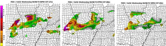
Severe Outbreak Central Plains Later Today. Our in-house TPI (Tornado Potential Index) values are poking into the extreme range by late afternoon from near Wichita to Kansas City and Springfield, Missouri. I wouldn’t be surprised to see a few large tornadoes touch down by the dinner hour. Source: HAMweather.
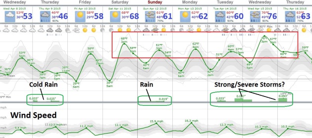
Springy Come-Back. Skies may brighten for a time today, allowing the mercury to top 50F (where we should be in early April). Steadier rain keeps temperatures in the 40s tomorrow, but then the mercury takes off over the weekend as the sun reappears – Saturday should be the nicer day to clean up the yard and wash the car – more badly needed rain falls Sunday, but the heaviest rains (and embedded T-storms) may hold off until the middle of next week as temperatures spike into the 70s. A severe outbreak by Wednesday of next week? It’s way too far off to say with any confidence, but I wouldn’t be surprised.
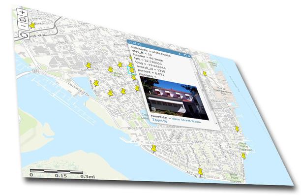
New Interactive Storm Surge Map Helps Residents See Potential Flood Risks. Here’s an excerpt of an interesting article (and useful new hurricane season tool) at The Island Packet: “The National Oceanic and Atmospheric Administration is testing a new feature that lets people get a look at what kind of damage and storm surges are possible, and using nearby Charleston for the preliminary model.The Experimental Storm Surge Simulator shows a street-level view of where water could rise in a storm surge. “Surveys of the public show there is still a consistent mis-understanding of what the storm surge is, and how deadly it can be,” reads the introduction to the app.
How Flood Insurance Could Drive Americans From Coasts. Increasingly severe (coastal) storms superimposed on rising seas increases the risk of damage, and the trends are already showing up in insurance premiums, according to Climate Central: “…The 8 inches or so of sea level rise since 1880 is contributing to regular high tide flooding along the Eastern seaboard and Gulf coast, including in Miami, Washington D.C. and Virginia Beach. By the middle of this century, seas are expected to be another four to 19 inches higher than they were at the turn of the century, threatening tens of billions of dollars worth of property in Florida alone. The new paper, written by Moore and NRDC water official Becky Hayat, lays out one vision for how Congress could re-imagine the flood insurance program in two years, when it’s next due to be reauthorized...”
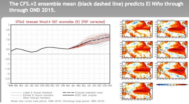
A Super-Sized El Nino in 2015 After All? Our on-again, off-again El Nino warming of Pacific Ocean water is very much on again as temperature anomalies continue to rise in the central and eastern Pacific. NOAA CPC is predicting overall temperature anomalies of 1.5 to 2C warmer than average by fall and winter, which would tend to imply a milder (drier) winter for Minnesota and the Upper Midwest. In theory. On paper. Your results may vary.
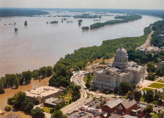
Remembering The Great Midwest Flood of 1993. I have vivid memories sandbagging the Racoon River in Des Moines, marveling at how high the waters were. Here’s an excerpt of a quick recap of historic flooding that spring, courtesy of cdapress.com: “…Dozens of major bridges were washed out from late June through early August of 1993. More than 5,000 barges, loaded mostly with grains and soybeans, were stuck on the Mississippi for weeks on end. The river is normally less than a mile wide, but by early July of 1993, it had grown as wide in places as seven miles! In total, according to my weather scrapbooks, more than half of the levees along the Mississippi River and its various tributaries were broken by the surging floodwaters. In St. Paul, Minn., in late June of 1993, the downtown airport virtually “disappeared” under several feet of water. Town after town along the Mississippi River southward past severely flooded St. Louis, Mo., saw their levees break and their houses and crops washed away. The entire town of Valmeyer, Ill., was moved to higher ground some 500 feet above the level of the Mississippi...”
Photo credit above: “US Army Corp of Engineers photo of the Missouri River’s damage to US Highway 63, Jefferson City, Missouri, near the Missouri Capitol building during the “Great Flood of 1993”. National Guardsmen created sandbag levees in the parking lot, but the building was still several feet above the water line.” Courtesy of Wikipedia, which has more information here.
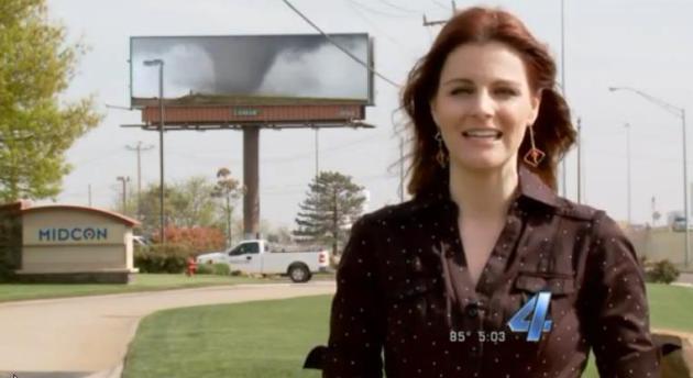
Digital Billboards Warn Drivers of Tornado Risk. This makes sense, especially considering you’re a sitting duck sitting in your vehicle. KFOR.com in Oklahoma City has the video and story – here’s an excerpt: “…It may be the last opportunity to warm somebody that they need to be careful as they travel down the road.” said Lamar General Manager, Bill Condon. “We have the ability to get the message out in minutes.” There are 28 digital billboards around Oklahoma City, 24 of them will be used for tornado warnings because they are located on highways around town…”

Better Method For Forecasting Hurricane Season? Is a new model out of the University of Arizona capable of a consistently more accurate/reliable hurricane forecast? I guess we’ll find out soon. Here’s an excerpt from ScienceDaily: “…The team developed the new model by using data from the 1950 to 2013 hurricane seasons. They tested the new model by seeing if it could “hindcast” the number of hurricanes that occurred each season from 1900 to 1949. “It performed really well in the period from 1949 to 1900,” Davis said. “That’s the most convincing test of our model.” Other investigators have estimated that damages from U.S. hurricanes from 1970 to 2002 cost $57 billion in 2015 dollars — more than earthquakes and human-caused disasters combined for the time period...”
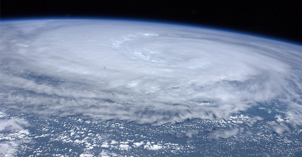
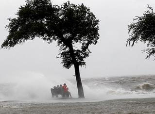
Under Debate: Social Media’s Value For Delivering Hurricane News. Can we rely on Twitter, Instagram and Facebook for the biggest weather stories? How do we insure that consumers are getting information from trusted, verified sources? Here’s an excerpt of a very interesting story at The Palm Beach Post: “Their grandparents learned of hurricanes in the newspaper, their parents on CNN. Today’s young people might get their news from their pals on Facebook. And what about the generation after that? That’s what really scares some weather forecasters and emergency managers. “Twitter can be wrong and we can’t,” Jim Forsyth, news director of San Antonio news radio station WOAI, told a session of this week’s National Hurricane Conference in Austin, Texas…” (Hurricane Irene file image: NASA).
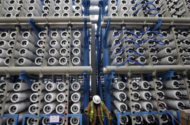
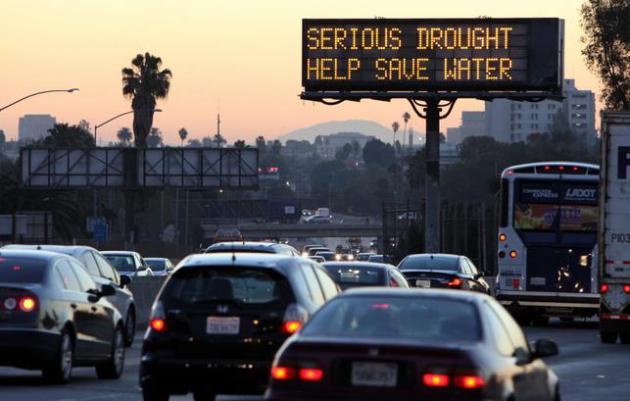
Will Turning Sea Water Into Drinking Water Help Drought-Hit California. Desalination plants are still prohibitively expensive and energy-intensive. But Santa Barbara is dusting off an old initiative to turn sea water into drinking water, a trend which may expand to other coastal cities suffering through prolonged drought. Here’s a clip from NPR: “…That briny waste is one of many concerns raised by environmentalists and other critics of desalination plants like this one and others that are being planned and built along the California coast. “The biggest concern about desalination is that it is expensive, it’s energy-intensive and it has a lot of side effects — a lot of unintended consequences to marine life both from the intake and the discharge,” says Marco Gonzalez, the executive director of the Coastal Environmental Rights Foundation. Right now, the sources of electricity available to run desalination plants are not environmentally friendly…”
File photo credit above: “In this March 11, 2015, file photo, a worker climbs stairs among some of the 2,000 pressure vessels used to convert seawater into fresh water through reverse osmosis in the western hemisphere’s largest desalination plant in Carlsbad, Calif. The Carlsbad Desalination Project, scheduled to start operations in late 2015, is expected to provide 50 million gallons of fresh drinking water a day.” (AP Photo/Gregory Bull, File).

This Is The Back-Up Plan If All Our Crops Are Wiped Out. Well there’s a lovely thought, and odds overwhelmingly favor this will never happen. But it’s good to have an insurance policy, right? Here’s a clip from a story at The Washington Post: “…Here’s where the sci-fi ends: There are no aliens here, and no clones. Instead, the containers are full of humble seeds, frozen and preserved — hopefully forever (or long enough, anyway). Ultimately, there’s enough room to store 2.25 billion of them. Scientifically inclined — and worried — humans built this. It’s the pinnacle of an ancient quest to store seeds so as to preserve agricultural diversity and give a backstop against any crop disaster…”


TODAY: Mostly cloudy, closer to average. Winds: E 10. High: near 50
WEDNESDAY NIGHT: Cloudy, rain arrives late. Low: 38
THURSDAY: Rain likely. A bit greener out there. High: 44
FRIDAY: Slow clearing and milder. Wake-up: 34. HIgh: 57
SATURDAY: Jolt of spring fever. Breezy with lukwarm sun! Wake-up: 35. High: 65
SUNDAY: Showers, possible T-storms. Wake-up: 46. High: 63
MONDAY: Sunny intervals, still pleasant. Wake-up: 43. High: 61
TUESDAY: Scattered showers, few T-showers possible. Wake-up: 42. High: near 60
Climate Stories….

The Global Warming “Pause” is More Politics Than Science. Here’s the intro to a story at The ABC Network in Australia: “Over the past 17 years, the Earth has warmed rapidly, accumulating energy at a rate equivalent to more than four atomic bomb detonations per second. That’s over 2 billion atomic bombs worth of heat built up on our planet since 1998. As discussed in a new book by one of us (Dana Nuccitelli) Climatology versus Pseudoscience, research has shown that much of the heat buildup during that time was deposited in the deep layers of the Earth’s oceans, temporarily keeping it from the surface…”
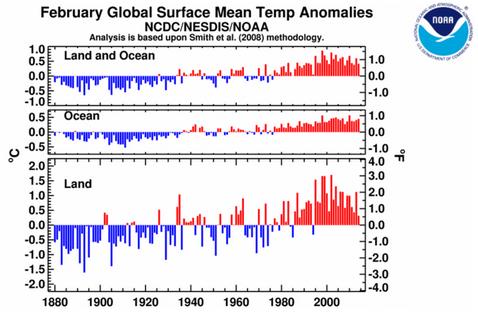
Let’s Call It: 30 Years of Above-Average Temperatures Means The Climate Has Changed. Here’s an excerpt from The Conversation: “…As you can see in the graphic above, ocean temperature doesn’t vary as much as land temperature. This fact is intuitive to many people because they understand that coastal regions don’t experience as extreme highs and lows as the interiors of continents. Since oceans cover the majority of the Earth’s surface, the combined land and ocean graph strongly resembles the graph just for the ocean. Looking at only the ocean plots, you have to go all the way back to February 1976 to find a month below average. (That would be under President Gerald Ford’s watch.)…”
Graphic credit above: “Temperature history for all Februaries from 1880-2014.” NCDC .
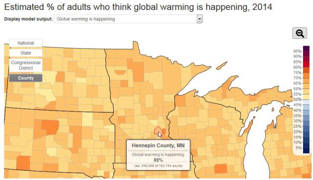
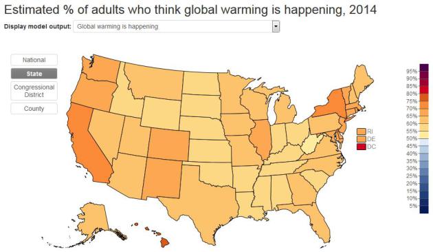
Acknowledging Climate Change, County by County. The Yale Project on Climate Change Communication has an interactive map that shows the level of interest/engagement broken down by couunty or congressional district. Overall 63% of Minnesotans believe warming is taking place and man is the primary driver of this observed warming. Nationwide the percentage is an identical 63%.

New NORAD Chief: Increased Russian Patrols, Climate Change Raise Strategic Concerns. Yes, The Air Force is acknowledging the obvious – arctic ice is shrinking (and thinning) and that has geopolitical implications; here’s a clip from an interview at Colorado Public Radio: “…Well, the Arctic ice pack is receding. I mean that’s clear. We see that every year. We see it receding and so the question is now, ‘As it recedes, how much more commercial activity is going to be up there in the form of transportation… Resource extraction: Will companies and nations go up there for resource extraction, you know, oil, gas, minerals?’ … Clearly, the climate is changing and the ice pack is receding. The question is, ‘What does that mean in the future?’ And that’s what we’re trying to determine.”
Photo credit above: “A U.S. Air Force F-22 intercepts a Russian bomber near Alaska.” (Courtesy of U.S. Air Force).

British Daily’s Campaign To Prevent Climate Change Raises Bold Questions About Role of Press Advocacy. Here’s the intro to an interesting post at Unsocial Media: “The Guardian, the London daily that has risen from a respected but fringe player on the British political scene to a major transatlantic voice of liberal thought, did something notable and gutsy a few weeks ago, and just about nobody on this side of the ocean paid any attention. Flanked by stories and commentaries, Alan Rusbridger, the editor credited with leading the Guardian’s rise, announced March 6 that his organization was launching a campaign intended to head off the climate catastrophe that the scientific consensus has concluded is unavoidable without deep changes in public policy and industrial practice…”

70% of Western Canadian Glaciers to Disappear by 2100. The Toronto Star has more details – here’s a link and excerpt: “Go see Canada’s glorious glaciers while you still have a chance. Seventy per cent of Western Canada’s glaciers — some of them popular destinations in Alberta and British Columbia — will likely be gone by the end of this century, according to shocking new projections published in Nature Geoscience Monday. “These glaciers are an important part of our landscape and we take it for granted . . . the landscape isn’t going to look the same,” said Garry Clarke, a glaciologist at the University of British Columbia and one of the study’s authors…”
Study: D.C. Residents Worry About Global Warming More Than Anyone Else in U.S. Here’s an excerpt from The Capital Weather Gang: “…Levels of concern about global warming have been strongly tied to political party affiliation. A Yale University study conducted last year found that 81 percent of Democrats are worried about global warming, compared with only 19 percent of conservative Republicans. About 75 percent of registered voters in the District are Democrats, which plays a key role in local global warming attitudes...”

Democracy vs. Psychology. Why People Keep Electing Idiots. Possibly my new favorite headline of the year, courtesy of The Guardian. Here’s an excerpt: “…What’s going on here? Logically, you’d want an intelligent person who understands the best approach and methods for running a country in the best possible way. But no, people seem drawn to demonstrations of questionable intellectual abilities. There are a wide variety of ideological, cultural, social, historical, financial and other factors involved, because politics incorporates all of these things, but there are also some known psychological processes that may contribute to this phenomenon…”

