Heavy Rain Since June

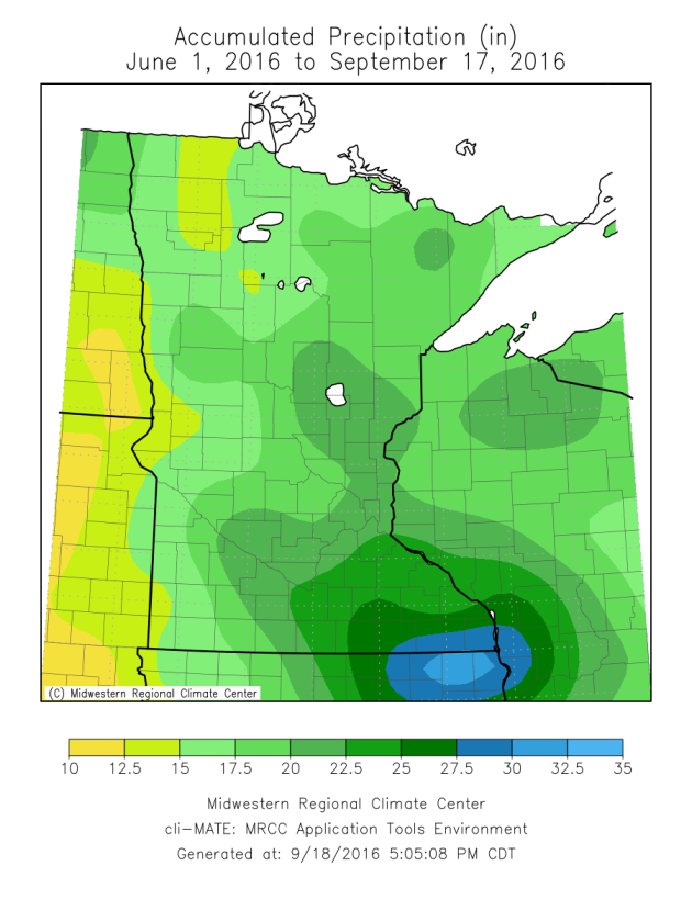
If there has been one story that has stuck out the past few months, it’s been the rounds of heavy rain across the region. From June 1 – September 17, the Twin Cities has received 19.97″ of rain. That is the ninth largest total during that time period in the history of Twin Cities record keeping (largest was 25.24″ in 1997). Some parts of southeast Minnesota have picked up over two feet of rain since June 1st.
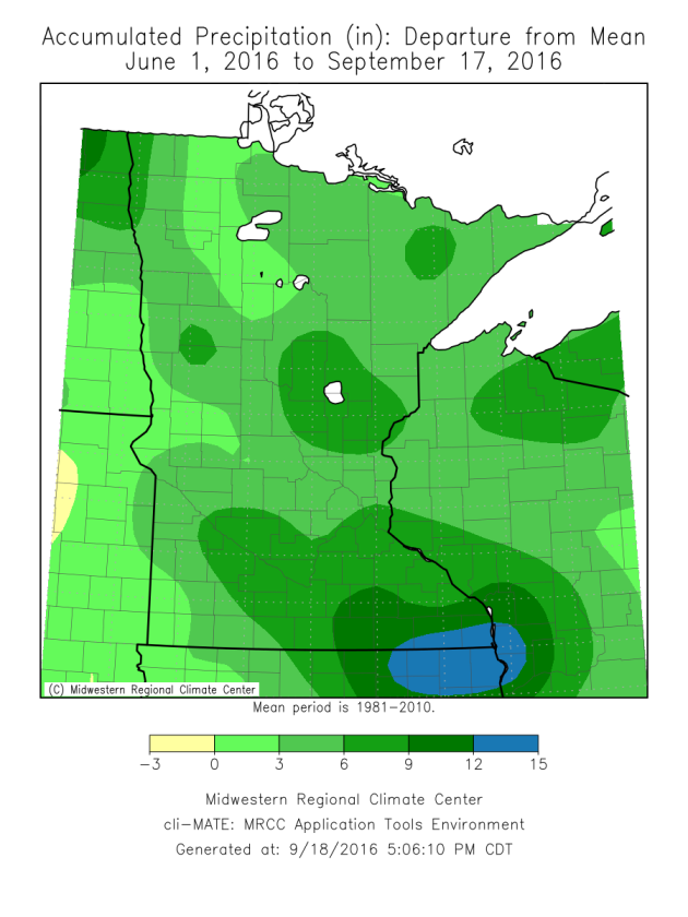
The entire state has seen above average precipitation for that same time period (since June 1), with some areas of southeast Minnesota a good 9-15″ above average. It looks like we’ll be able to add to those totals over the next week – more on that in a moment.
By Paul Douglas

MONDAY: Clouds, spotty shower. High 77. Low 55. Chance of rain 40%. Wind W 8-13 mph.
TUESDAY: Patchy clouds, stray PM shower. High 78. Low 63. Chance of rain 30%. Wind S 3-8 mph.
WEDNESDAY: T-storms, locally heavy rain. High 80. Low 61. Chance of rain 70%. Wind S 10-15 mph.
THURSDAY: Showers taper, gradual clearing. High 70. Low 58. Chance of rain 30%. Wind NE 8-13 mph.
FRIDAY: Dry start, more T-storms arrive late. High 73. Low 59. Chance of rain 60%. Wind E 10-15 mph.
SATURDAY: Sticky with T-storms, some heavy. High 76. Low 57. Chance of rain 70%. Wind SE 10-20 mph.
SUNDAY: Front stalls, more heavy T-storms. High 69. Low 55. Chance of rain 80%. Wind W 10-15 mph.
_______________________________________________
This Day in Weather History
September 19th
1998: 1 to 1 3/4 inch hail falls in Meeker, Wright, Todd, and Wilkin Counties. Winds were also estimated over 50 knots / 58 miles per hour.
1980: Golfball to baseball sized hail hits St. Paul. One company has 75 to 95 percent of the glass in their greenhouses smashed.
_______________________________________________
Average Temperatures & Precipitation for Minneapolis
September 19th
Average High: 70F (Record: 94F set in 1895)
Average Low: 51F (Record: 33F set in 1991)
Average Precipitation: 0.09″ (Record: 2.98″ set in 1907)
________________________________________________
Sunrise/Sunset Times for Minneapolis
September 19th
Sunrise: 6:57 AM
Sunset: 7:15 PM
*Length Of Day: 12 hours, 18 minutes and 3 seconds
*Daylight Lost Since Yesterday: ~3 minutes and 6 seconds
*Next Sunrise That Is At/After 7 AM: September 21st (7:00 am)
*Next Sunset That Is Before 7 PM: September 28th (6:58 pm)
Minnesota Weather Outlook
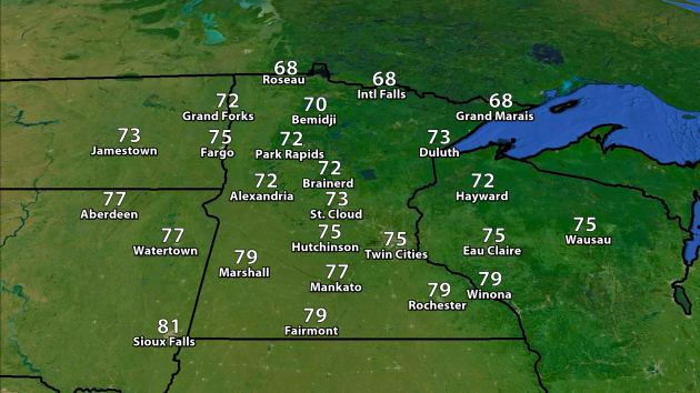
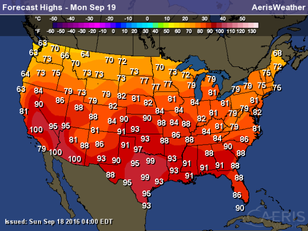
Expected Highs Monday.
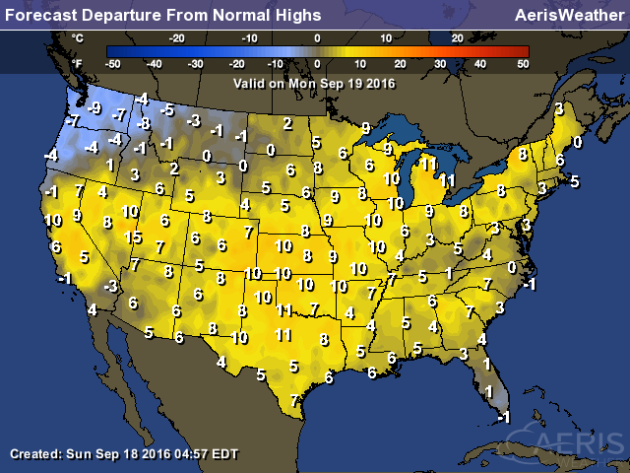
Highs will be a touch cooler Monday across the state behind a cold front, with mid 70s expected in the Twin Cities. Parts of northern Minnesota will be unlikely to get out of the 60s for highs once again.
Temperatures will continue to remain warm over the next week in southern Minnesota, with highs in the 70s likely just about every day. We’re still watching the last week of the month for a potential cool down across the region – if the models are right, there could potentially be a number of days with highs in the 50s and 60s during that time frame in the Twin Cities.
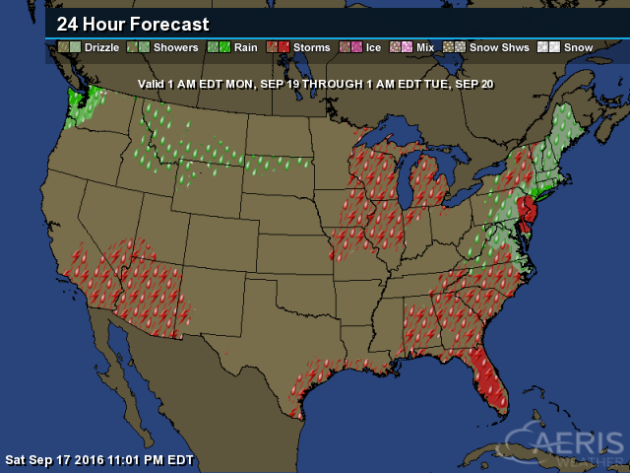
Rain chances continue to be high as we head toward the middle of the week across the region, with periods of showers and storms possible. Rainfall totals could top 2″ here in the Twin Cities by the end of next weekend.
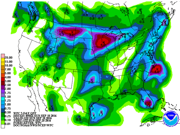
Through next Sunday morning, the Weather Prediction Center has the heaviest rain falling across parts of southern and central Minnesota – including here in the Twin Cities. The potential exists for 2-4″+ of rain over the next seven days.
Thanks for checking in and have a great Monday! Don’t forget you can follow me on Twitter (@dkayserwx) or on Facebook (Meteorologist D.J. Kayser)!
– D.J. Kayser


