by Paul Douglas | Aug 19, 2017 | Blog
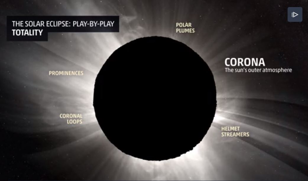
Eclipse Play-By-Play “meteorologist Mark Elliot goes through a simulation of experiencing the total solar eclipse on Aug. 21 from the perspective of an observer on the ground. As a science editor for Mashable, I know the ins and outs of what causes an eclipse,...
by Paul Douglas | Aug 19, 2017 | Blog
75 F. high on Friday in the Twin Cities. 80 F. average high on August 18. 85 F. maximum temperature on August 18, 2016. August 19, 2007: Record 24-hour maximum rainfall of 15.10 inches set in Hokah, MN (Houston county). This 24-hour total contributed to the record...
by Paul Douglas | Aug 18, 2017 | Blog
4.37″ rainfall so far in August. 2.49″ average rainfall, month to date. 74 F. high yesterday in the Twin Cities. 81 F. average high on August 17. 86 F. high on August 17, 2016. August 18, 1953: Four heifers near St. Martin were lucky; a tornado picked them...

by Paul Douglas | Aug 17, 2017 | Blog
81 F. average Twin Cities high on August 16. 86 F. maximum temperature on August 16, 2016. August 17, 1946: A tornado kills 11 people in the Mankato area around 6:52PM. A 27-ton road grader is hurled about 100 feet. Another tornado an hour later destroys downtown...
by Paul Douglas | Aug 16, 2017 | Blog
78 F. maximum temperature yesterday in the Twin Cities. 81 F. average high on August 15. 82 F. high on August 15, 2016. August 16, 1981: Chilly temperatures are felt across Minnesota. Tower reports a low of 33 degrees. It’s Not Your Imagination: It’s...
.gif)
by Paul Douglas | Aug 15, 2017 | Blog
Simulated Radar Ahead… Here’s the simulated radar from AM Tuesday to AM Thursday, which shows another round of showers and storms pushing through the region midweek. Note that the best chance of heavier rain moves through during the day Wednesday before...
