Paul Douglas
  • Biography
  • Speeches
    • Testimonials
  • Entrepreneurial Approach
    • Paul’s Companies
  • Legal Storm
  • News
    • Scientific Sources
  • Contact
Select Page

Welcome Dry Spell Into Tuesday – Tracking “Matthew” in the Caribbean

by Paul Douglas | Sep 29, 2016 | Blog

62 F. high temperature in the Twin Cities yesterday. 66 F. average high on September 28. 77 F. high on September 28, 2015. September 29, 1876: An abnormally cool day occurs, with a high of 45 in the Twin Cities (normally the high should be 65 this time of year). A...
For First Time on Record: 2 Minnesota “Mega-Rain” Events in 2016

For First Time on Record: 2 Minnesota “Mega-Rain” Events in 2016

by Paul Douglas | Sep 28, 2016 | Blog

60 F. high on Tuesday in the Twin Cities. 67 F. average high on September 27. 82 F. high on September 27, 2015. .04″ rain fell at MSP International Airport yesterday. September 28, 1983: Late summer-like temperatures arrive in Minnesota with 91 degrees at...
Severe Flash Flooding – Maps Look More Like June than Late September

Severe Flash Flooding – Maps Look More Like June than Late September

by Paul Douglas | Sep 22, 2016 | Blog

71 F. high in the Twin Cities Wednesday. 70 F. average high on September 21. 81 F. high on September 21, 2015. September 22, 1996: A brief cold air funnel touchdown results in roof damage in Washington County. September 22, 1936: Summer-like heat continues with 101 at...
Another Sloppy Holding Pattern – Significant Flood Risk – Flash Flood Watch

Another Sloppy Holding Pattern – Significant Flood Risk – Flash Flood Watch

by Paul Douglas | Sep 21, 2016 | Blog

78 F. high yesterday at KMSP. 79 F. average high in the Twin Cities on September 20. 72 F. high on September 20, 2015. September 21, 2005: An unusually intense late season severe weather event affects parts of central Minnesota and west central Wisconsin during the...
A Touch Cooler Monday – Soggy Pattern Returns Mid Week

A Touch Cooler Monday – Soggy Pattern Returns Mid Week

by Paul Douglas | Sep 18, 2016 | Blog

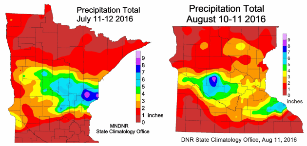
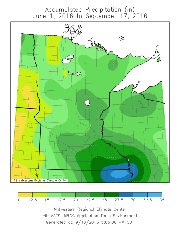
Heavy Rain Since June If there has been one story that has stuck out the past few months, it’s been the rounds of heavy rain across the region. From June 1 – September 17, the Twin Cities has received 19.97″ of rain. That is the ninth largest total...
« Older Entries

Caring For Creation Book

Recent Posts

  • Tracking Superior Refinery Fire Plume – Spotty Shower Today – Fine Weekend Brewing April 27, 2018
  • Spotty Instability Showers Next 36 Hours – Weekend Warming Trend April 26, 2018
  • An Extended Spring Fling – Wetter/Stormier Pattern Next Week? April 25, 2018

Archives

  • April 2018
  • March 2018
  • February 2018
  • January 2018
  • December 2017
  • November 2017
  • October 2017
  • September 2017
  • August 2017
  • July 2017
  • June 2017
  • May 2017
  • April 2017
  • March 2017
  • February 2017
  • January 2017
  • December 2016
  • November 2016
  • October 2016
  • September 2016
  • August 2016
  • July 2016
  • June 2016
  • May 2016
  • April 2016
  • March 2016
  • February 2016
  • January 2016
  • December 2015
  • November 2015
  • October 2015
  • September 2015
  • August 2015
  • July 2015
  • June 2015
  • May 2015
  • April 2015
  • March 2015
  • February 2015
  • January 2015
  • December 2014
  • November 2014
  • October 2014
  • September 2014
  • August 2014
  • July 2014
  • June 2014
  • May 2014
  • April 2014
  • March 2014

Latest Post

  • Tracking Superior Refinery Fire Plume – Spotty Shower Today – Fine Weekend Brewing
  • Facebook
  • Twitter
  • RSS
Website designed by Walt Kruhoeffer