Paul Douglas
  • Biography
  • Speeches
    • Testimonials
  • Entrepreneurial Approach
    • Paul’s Companies
  • Legal Storm
  • News
    • Scientific Sources
  • Contact
Select Page
From July to September in 24 Hours – Orange Cone Alert

From July to September in 24 Hours – Orange Cone Alert

by Paul Douglas | Jul 26, 2014 | Blog

81 F. high in the Twin Cities Friday. 83 F. average high on July 25. 83 F. high on July 25, 2013. .42″ rain fell at MSP International Friday morning. 2.24″ rain so far in July. 3.22″ average for July, to date. 28.07″ precipitation so far in...
Heating Up Into Saturday – Staying Safe While Camping During Severe Storms – Possible Climate Tipping Point?

Heating Up Into Saturday – Staying Safe While Camping During Severe Storms – Possible Climate Tipping Point?

by Paul Douglas | Jul 25, 2014 | Blog

82 F. high in the Twin Cities Thursday. 83 F. average high on July 24 (the average high has come down 1 degree). 78 F. high on July 24, 2013. July 24 in Minnesota Weather History. Source: MPX office of the National Weather Service: 2000: An F4 tornado hits the town of...
Perfect Midsummer Day – Implications of a Major Tornado Hitting a Major U.S. City?

Perfect Midsummer Day – Implications of a Major Tornado Hitting a Major U.S. City?

by Paul Douglas | Jul 23, 2014 | Blog

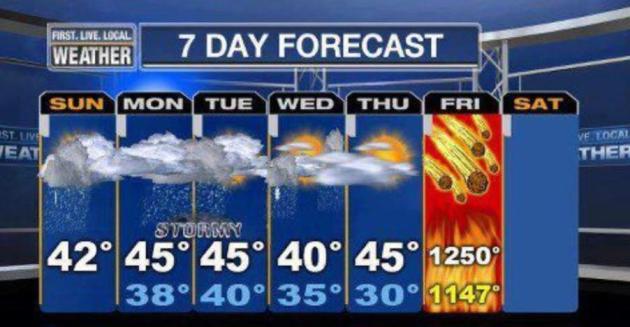
86 F. high in the Twin Cities Tuesday. 83 F. average high on July 22. 88 F. high on July 22, 2013. July 22, 1987: Greatest deluge ever in Twin Cities begins with 10 inches in six hours at the Twin City airport. A Slippery 7-Day Why do most TV stations put the weather...
Breathing Easier by Midweek. June: Warmest on Record, Worldwide

Breathing Easier by Midweek. June: Warmest on Record, Worldwide

by Paul Douglas | Jul 22, 2014 | Blog

92 F. high in the Twin Cities Monday. 76 F. peak dew point yesterday at 5:53 PM 84 F. average high on July 21. 81 F. high on July 21, 2013. July 21, 1972: A significant downpour occurs over a portion of Minnesota, with 10.84 inches of rain in 24 hours at Ft Ripley. 14...
Jungles of Minnesota: Severe Heat, then Severe T-storms

Jungles of Minnesota: Severe Heat, then Severe T-storms

by Paul Douglas | Jul 21, 2014 | Blog

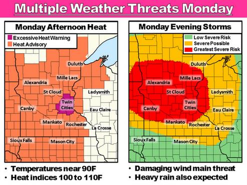
Excessive Heat Warning posted for the Twin Cities today. Moderate Risk of severe thunderstorms over much of Minnesota by this evening/tonight. 87 F. high in the Twin Cities Sunday. 84 F. average high on July 20. 82 F. high on July 20, 2013. July 20 in Minnesota...
« Older Entries
Next Entries »

Caring For Creation Book

Recent Posts

  • Tracking Superior Refinery Fire Plume – Spotty Shower Today – Fine Weekend Brewing April 27, 2018
  • Spotty Instability Showers Next 36 Hours – Weekend Warming Trend April 26, 2018
  • An Extended Spring Fling – Wetter/Stormier Pattern Next Week? April 25, 2018

Archives

  • April 2018
  • March 2018
  • February 2018
  • January 2018
  • December 2017
  • November 2017
  • October 2017
  • September 2017
  • August 2017
  • July 2017
  • June 2017
  • May 2017
  • April 2017
  • March 2017
  • February 2017
  • January 2017
  • December 2016
  • November 2016
  • October 2016
  • September 2016
  • August 2016
  • July 2016
  • June 2016
  • May 2016
  • April 2016
  • March 2016
  • February 2016
  • January 2016
  • December 2015
  • November 2015
  • October 2015
  • September 2015
  • August 2015
  • July 2015
  • June 2015
  • May 2015
  • April 2015
  • March 2015
  • February 2015
  • January 2015
  • December 2014
  • November 2014
  • October 2014
  • September 2014
  • August 2014
  • July 2014
  • June 2014
  • May 2014
  • April 2014
  • March 2014

Latest Post

  • Tracking Superior Refinery Fire Plume – Spotty Shower Today – Fine Weekend Brewing
  • Facebook
  • Twitter
  • RSS
Website designed by Walt Kruhoeffer