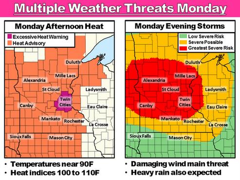
Excessive Heat Warning posted for the Twin Cities today.
Moderate Risk of severe thunderstorms over much of Minnesota by this evening/tonight.
87 F. high in the Twin Cities Sunday.
84 F. average high on July 20.
82 F. high on July 20, 2013.
July 20 in Minnesota Weather History. Source: MPX NWS:
2002: Dew points reached 84 degrees at Madison, Morris, and Olivia. This ties the all- time highest dew points seen by the State Climatology Office for Minnesota.
1934: Temperature topped out at 113 at Milan.
Heat Spike – MCS Risk
“Wow, I sure am enjoying this 100-degree heat index!” said no one, ever. Today will be a test: jungle-like heat and humidity, followed by an outbreak of potentially violent storms by tonight. Yes, something for everyone. And a far cry from last Monday, when a swirl of Canadian air had us reaching for sweatshirts and fiddling with our furnaces.
The good news, this instant-on heat wave lasts 1 day. Highs in the mid-90s, coupled with a drippy dew point rising into the upper 70s, will make it feel like 100-105F by late afternoon. The urban heat island adds a few more degrees, and there’s now an Excessive Heat Warning for the 7-country metro area.
The atmosphere becomes explosively unstable by late afternoon; a ripple of low pressure approaching from the Dakotas sparks a possible MCS by evening: a meso-convective system, which is a particularly intense, fast-moving squall line capable of 70-85 mph wind gusts.
NOAA SPC has elevated the risk to “moderate” across much of Minnesota. It may be tough getting much sleep tonight with all the crashing & banging. I could see power outages, so have flashlights & candles ready to go.
Relief arrives midweek as dew points drop into the 50s.
But today? Stay hydrated and keep an eye on the northwest sky.
* graphic above: Twin Cities National Weather Service.
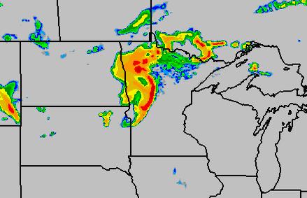
WRF: 10 PM Tonight. NOAA’s high-resolution, 4 km WRF model shows a possible MCS or derecho pushing out of the Red River Valley into northern and central Minnesota early tonight, the bow-echo appearance suggestive of strong, even violent straight-line winds impacting the Brainerd and Alexandria lakes area, as well as Little Falls, Duluth. and possibly St. Cloud and the Twin Cities. The risk of wind damage appears greatest north of MSP. Map: HAMweather.
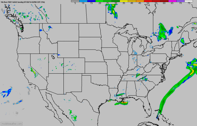
MCS Potential. NOAA’s 4 km WRF model shows a possible meso-convective system flaring up later today and tonight, pushing from the eastern Dakotas across Minnesota with potentially violent wind gusts and frequent lightning overnight. The strongest winds may pass just north of MSP, but it looks like a close call. Future radar: NOAA and HAMweather.

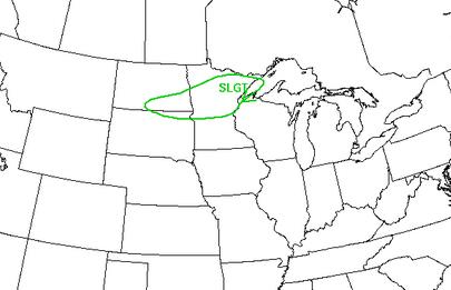
Moderate Risk = Strong Chance of Violent T-storms. NOAA SPC has much of Minnesota under a “moderate” threat of severe storms later today and tonight, with the greatest risk coming from straight-line wind gusts with a possible MCS or even a derecho. A 45% probability means a nearly 50-50 chance of severe weather within 25 miles of any city in the purple-shaded area, including St. Cloud, Brainerd and the Twin Cities.
Flash Flood Risk. NOAA WPC shows a slight chance of training T-storms with rainfall rates high enough to spark potential flash flooding from near Fargo, Little Falls and Brainerd to Duluth and the North Shore.
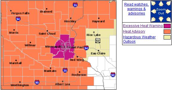
Excessive Heat Warning Twin Cities Metro – Heat Advisory for Greater Minnesota. The urban heat island will add at least 4-6F worth of additional heat later today, making it feel like 100-105. Here’s an update from the Twin Cities National Weather Service:
...DANGEROUSLY HOT AND HUMID CONDITIONS EXPECTED LATE MONDAY
MORNING THROUGH MONDAY EVENING...

AN EXCESSIVE HEAT WARNING IS IN EFFECT FOR THE TWIN CITIES
METROPOLITAN AREA...WITH A HEAT ADVISORY IN EFFECT ACROSS THE
REST OF CENTRAL AND SOUTHERN MINNESOTA AND FAR WESTERN
WISCONSIN...FROM LATE MONDAY MORNING THROUGH MONDAY EVENING. HIGH
TEMPERATURES ARE EXPECTED TO REACH THE LOWER 90S. THIS COMBINED
WITH OPPRESSIVE DEW POINTS IN THE MIDDLE TO UPPER 70S WILL RESULT
IN HEAT INDICES RANGING FROM 100 TO 110 DEGREES. THE WARMEST
CONDITIONS WILL BE FOUND IN THE MINNESOTA RIVER VALLEY.

...EXCESSIVE HEAT WARNING REMAINS IN EFFECT FROM 11 AM TO 9 PM
CDT MONDAY...

* TEMPERATURES...HIGHS IN THE LOWER 90S WITH HEAT INDICES AROUND
  105 DEGREES.

* IMPACTS...GIVEN THE COOL SUMMER THUS FAR...THESE CONDITIONS MAY
  LEAD TO A HEIGHTENED RISK OF HEAT RELATED STRESS AND
  ILLNESS... ESPECIALLY FOR THE YOUNG AND ELDERLY...AND THOSE
  WITHOUT AIR CONDITIONING.
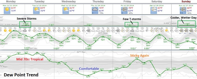
More Big Swings in Temperature and Dew Point. Long-range guidance shows dew points in the mid 70s later today, about as sticky as it ever gets. I wouldn’t be surprised to see an 80F dew point somewhere between the Twin Cities, the Quad Cities and Madison by this evening. Extreme low-level moisture and instability fuels strong to severe storms tonight, followed by a puff of cooler, more comfortable Canadian air by midweek. T-storms may form along a warm front Friday; Saturday the more tolerable day of the weekend for outdoor plans. Not sure I’m buying 60s and rain for next Sunday (yet) but you’ve been warned.
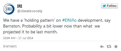
A Super-Strong El NIno Is Now Off The Table. Here’s What That Means. Meteorologist Eric Holthaus takes a look at the dwindling prospects for a major El NIno warming event in the Pacific at Slate; here’s an excerpt: “…New data released Thursday by the International Research Institute for Climate and Society—a climate forecasting partnership between Columbia University and NOAA—shows that while ocean temperatures in the tropical Pacific are still above normal, the atmospheric response has so far been sluggish. After an impressive ramp up earlier this year, that means the coming El Niño is increasingly likely to fall a bit flat…”
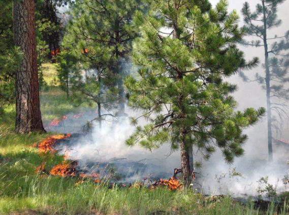
Northwest Wildfires: Situation Worsens With Five New “Large, Uncontained” Fires. Oregon Live has an update; here’s the introduction: “A dozen new wildfires have started in Oregon and six have started in Washington over the past 24 hours — covering more than 68,000 acres. That adds to an already fierce wildfire season in the Northwest, with 25 large, uncontained fires, according to the Northwest Interagency Coordination Center. The number of fires classified as “large” has increased by five since yesterday…”
Photo credit above: “Waterman Complex wildfire at Ochoco Pass.” Credit: InciWeb.
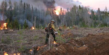
Wildfire Risk Increasing Every Year. Canada is experiencing the same trends as the western USA; here’s an excerpt from News1130 in Vancouver: “The total area affected by wildfires in British Columbia has been on an upward trend for years. While the numbers of hectares burned by wildfires goes up and down by the season, the 10-year average has been rising since 1991 according to government stats...”
File photo above: DNR.
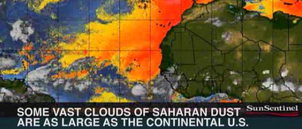
Hopeful Signs for Hurricane Season. The Sun-Sentinel in Fort Lauderdale, Florida has an interesting article focused on hurricane potential. The combination of Saharan dust, more wind shear than usual and cooler ocean water temperatures may put a brake on tropical formation in the coming weeks. Then again, all it takes is one. Here’s an excerpt: “So far, it’s looking good for Florida as the heart of the hurricane season approaches. Consider:
• Abnormally strong bursts of Saharan dust are drifting over the Atlantic — and may subdue the tropics like they did last year, experts say.
• The tropical Atlantic is cooler than normal for the moment, making it harder for storms to bulk up…”

Wedding Goes On Despite Wildfire Raging Nearby. A few weeks ago it was a tornado, now it’s wildfires burning across the Pacific Northwest. Gannett’s NWCN.com has the story; here’s a clip: “Brides often worry if it’s going to rain on their wedding day, but Jennifer Faulkner never thought to worry about the power going out and a major wildfire raging just outside her wedding venue. “You have to roll with it, right? There’s no reason to waste your time turning into bridezilla,” she said with a chuckle…”


TODAY: Excessive Heat warning, severe storms possible by evening. Winds: S 10-15. Dew point: 77. High: 93 (heat index: 100-105).
MONDAY NIGHT: Tropical humidity levels with T-storms, some severe (especially north of MSP). Low: 75
TUESDAY: Unsettled, isolated T-storm possible. Dew point: 71. High: 86
WEDNESDAY: Sunny, breathing easier. Dew point: 57. Wake-up: 64. High: 81
THURSDAY: Less sun, few storms south/west. Wake-up: 61. High: near 80
FRIDAY: Sticky, few more T-storms. Dew point: 66. Wake-up: 63. High: 80
SATURDAY: The nicer day of the weekend; T-storms up north. Wake-up: 67. High: 83
SUNDAY: Early sun, PM showers, T-showers. Wake-up: 63. High: 73
Climate Stories….

The Carbon Taxes We’re Already Paying. Here’s an excerpt of an Op-Ed at The Los Angeles Times that caught my eye yesterday. We’re already paying a tax, we just don’t realize it yet. Here’s a clip: “…The fact is that American taxpayers are paying for the costs of climate change now. These costs don’t hit us all at once but sporadically, in different places and at different times. They don’t feel like a carbon tax, though they amount to one. Every time we use fossil fuels, we increase our tax burden, a burden that unfolds like a sequence of trap doors, just like climate change itself. The costs of recovering from climate-change signposts like Superstorm Sandy, Hurricane Katrina and major drought are well documented. What’s less known are the costs — the trap doors — that have normally been accounted for in some ledger other than atmospheric chaos…”
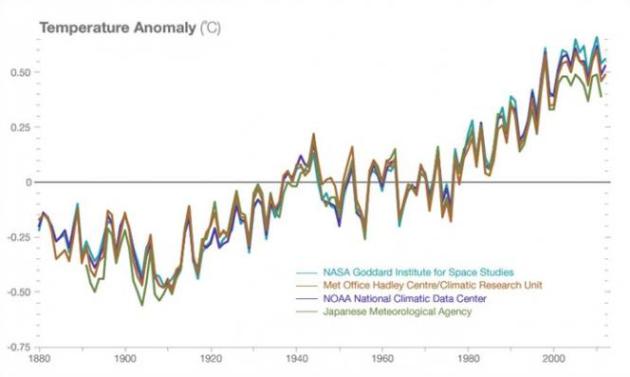
Climate Change Broke Temperature Records in 2013. Inquisitr.com has a good summary of the state of the scientific consensus around global trends; here’s an excerpt: “The Inquisitr has reported on climate change many times in the past, speculating about the long term effects of global warming. Rumors of its damaging effects range from the extinction of redheads to the vulnerability of the military. While it’s still uncertain what will happen to the planet in the long run, few experts deny the existence of climate change or humanity’s influence on it. Some are still skeptical, of course, but NASA reports that 97 percent of scientists agree on global warming and cites a long list of scientific organizations that support the theory of climate change..”
Former Treasury Secretary Paulson Calls Climate Change “Biggest Risk of Our Time”. Paulson explains that it’s not just an environmental risk, but an ongoing and accelerating business risk. Here’s an excerpt of some recent comments in an interview at Oregon Live: “…If you include this into your business decision-making framework, there will be important investments you make which increase our resilience and ability to adapt to the changes that are coming. There will be important decisions you make geared toward replacing old technologies with newer, cleaner, more efficient technologies. Investors, in my judgment, really need to insist on getting full disclosures and really need to understand the risks on certain investments. They need to understand the associated carbon emissions. They need to understand risks around stranded assets…” (File photo: NASA).

Guest Opinion: If You Eat You Care About Climate Change. Here’s a clip of an Op-Ed from a farmer in Utah at Provo’s Daily Herald: “…You don’t have to be a climate change expert to understand severe weather. Why should you care? It’s pretty simple. If you drink milk or eat beef, you depend on alfalfa growers like me, because cows and cattle eat what we grow. We have been getting hit hard, and I think it is important for people in other parts of the country to understand how. Most of us here in the West are struggling through the worst drought in a century. It’s hotter, too. When crops are hit with extreme heat, they don’t grow as fast...”

Commentary: A Local Climate Change Laboratory. The author of this Op-Ed talks about the challenges facing Texas, from drought and sea level rise; not enough water – too much water (where it’s not wanted). Here are a few excerpts at The Indiana Gazette that made my head spin: “…Numbers indicate the competing interests: Due to the current drought, the U.S. Department of Agriculture has designated 240 of Texas’ 254 counties as “primary natural disaster areas.” And the Texas Commission on Environmental Quality reports that at least 48 cities are within 180 days of water exhaustion…And while fracking in the Eagle Ford shale has been an enormous boon to the economy of south Texas, it requires enormous amounts of water, somewhere between 2 million and 8 million gallons per well...” (File photo: Earthworks).
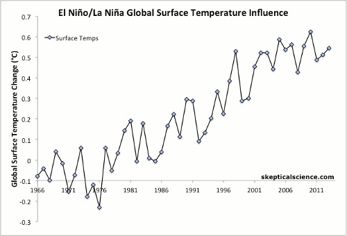
Well-Estimated Global Warming by Climate Models. Here’s another report that confirms the much-advertised “warming pause” is a myth; it’s critical to include the influences of ENSO on global trends, the El Nino – La Nina oscillation in the Pacific. Here’s an excerpt from Shaping Tomorrow’s World: “Has global warming “stopped”? Do models “over-predict” warming? There has been much recent talk in the media about those two questions. The answer to the first question is a fairly clear “no.” Global warming continues unabated. To illustrate, for the coverage-bias-corrected data published by Cowtan and Way last year, the temperature trend for the last 15 years up to and including 2013 is significant—in the same way that the trend was significant for the last 15 years in 2000 and in 1990. So from any of those vantage points, the Earth has warmed significantly during the preceding 15 years...”
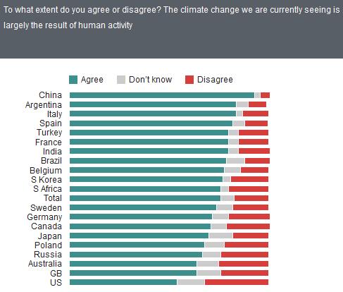
An Anglosphere Climate Skeptic Bias? The chart above highlights the ongoing climate denial campaign in the USA, Britain and Australia. The Chinese have little doubt about what’s going on, which I find breathtakingly ironic, since they are now admitting the majority of global greenhouse gases. Graphic source: Global Trends Survey.
