.gif)
.png)
.png)


__________________________________________________________________________

_______________________________________________________________________
February Temperature & Precipitation Outlook
Here’s NOAA’s February temperatures and precipitation outlook, which suggests that colder and wetter than average conditions will be found across the northern tier of the nation and especially from the Midwest to the Northeast. However, warmer and drier than average conditions look to continue across the southern and western US.


____________________________________________________________________________


____________________________________________________________________________
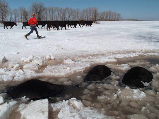
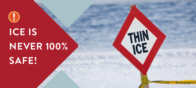
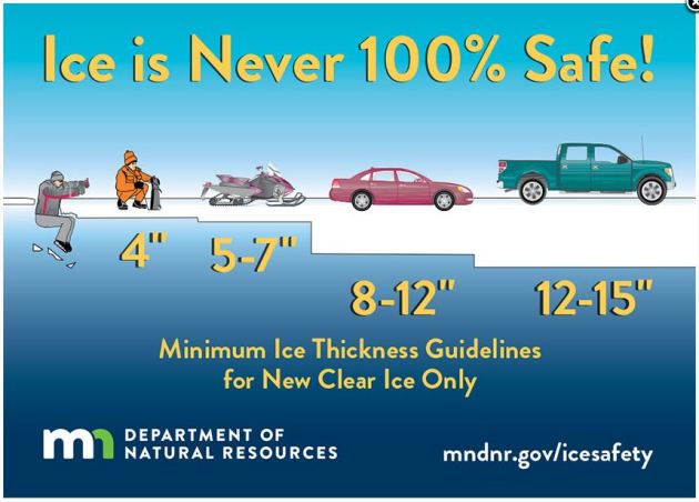
General Ice Thickness Guidelines
Under 4″ – STAY OFF
4″ – Ice fishing or other activities on foot
5″ – 7″ – Snowmobile or ATV
8″ – 12″ – Car or small pickup
12″ – 15″ – Medium truck
Many factors other than thickness can cause ice to be unsafe.
White ice or “snow ice” is only about half as strong as new clear ice. Double the above thickness guidelines when traveling on white ice.
___________________________________________________________________
.png)
.gif)
High temps across the country on Saturday will still be running a bit below average from the Lower Mississippi Valley to the Northeast, while another surge of even colder air will start making its way back into the Upper Midwest. Meanwhile, folks from the Plains to the West Coast will see temps in the +10F to +20F above average range.


Weather Outlook Ahead
.gif)
According to NOAA’s WPC, the 5-day precipitation outlook suggests areas of heavy precipitation continuing in the Northwest with several inches of precipitaiton from the Central and Northern Rockies to the northern Cascades. There will also be another batch of heavy precipitation in the Lower Mississippi Valley/Gulf Coast States through the middle part of next week. Unfortunately, much of California and the Southwest will stay dry over the next 5 to 7 days.
.gif)
Snowfall Potential Ahead
.png)
By Todd Nelson, filling in for Douglas.
Extended Forecast
SATURDAY: 1″ to 2″ of fluffy snow by late afternoon/evening. Winds: N 5-10. High: 19.
SATURDAY NIGHT: Light snow ends early. Cold. Winds: N 5-10. Low: -1 (Feels like: -15F).
SUNDAY: Cold sunshine. Fine football weather. Winds: WNW 5-10. High: 7.
MONDAY: Sub-zer start. PM snow southern MN. Winds: WSW 5. Wake-up: -2. High: 15.
TUESDAY: Mix of sun and clouds. Winds: NNW 5. Wake-up: 0. High: 15.
WEDNESDAY: Clouds thicken. Snow at night. Winds: WSW 5. Wake-up: 4. High: 16.
THURSDAY: AM flurries. Peeks of PM sun. Winds: NNE 5. Wake-up: 1. High: 15.
FRIDAY: Snowy across southern MN again. Winds: NNE 10-15. Wake-up: 2. High: 18.
_______________________________________________________
This Day in Weather History
February 3rd
1989: Bitterly cold temperatures occur across Minnesota with lows in the 40-below-zero range in the north.
1947: A strong dust storm hits Crookston with winds near 50 mph. Visibility was reduced down to 300 feet.
_______________________________________________________
Average High/Low for Minneapolis
February 3rd
Average High: 26F (Record: 51F set in 1934)
Average Low: 9F (Record: -32F set in 1996)
Record Rainfall: 0.80″ set in 1919
Record Snowfall: 8.8″ set in 2016
_________________________________________________________
Sunrise/Sunset Times for Minneapolis
February 3rd
Sunrise: 7:30am
Sunset: 5:24pm
Hours of Daylight: ~9 hours & 54 minutes
Daylight GAINED since yesterday: ~ 2 minutes & 37 seconds
Daylight GAINED since winter solstice (December 21st): 1 Hour 8 Minutes
__________________________________________________________
Moon Phase for January 30th at Midnight
3.7 Days Since Full “Snow” Moon
.gif)
_________________________
Temp Outlook For Saturday


Here’s the temperature outlook as we head into the 2nd week of February, which suggests that colder than temperatures will be in place across much of the region. While temperatures will likely be colder than average, it doesn’t appear to have as big of a bite that it had at the end of December and early January.

8 to 14 Day Temperature Outlook
As we head into the 2nd week of February, warmer than average temperatures will still be in place across the Southwestern and Southeastern US, while much of the central and northern part of the nation will still be running below average.


_________________________________________________________________________

______________________________________________________________________________

_______________________________________________________________________________

___________________________________________________________________________

_______________________________________________________________________________
“How Australian trees beat extreme heat by sweating”
“Researchers from Western Sydney University have uncovered the novel strategies Australian eucalypt trees use to survive extreme heatwaves. One remarkable process involves the tree evaporating large volumes of water through its leaves in a process is similar to sweating. The study involved the University’s novel Whole Tree Chambers, which give researchers the ability to grow trees up to a height of 9 m (29.5 ft) in fully enclosed and controllable environments that allow air temperature, soil moisture, irrigation, CO2 levels and humidity to be manipulated. Six Parramatta Gums (Eucalyptus parramattensis) were grown in the chambers for 12 months under conditions simulating an average of 3° C (5.4° F) warmer than average, while six were grown under ambient temperature conditions.”

______________________________________________________________________________
Thanks for checking in and don’t forget to follow me on Twitter @TNelsonWX