Super Bowl LII
Thanks to my good friend Lee Huffman for sharing the pictures below. Lee has been enoying the sights and festivities surrounding Super Bowl LII and says the anticipation surrounding the big game has been palpable!


Weather Outlook for Super Bowl LII

Plans for the big game on Sunday? Here’s the weather outlook for Sunday, which shows cold weather in place all day! Highs will only be in the single digits with sub-zero wind chills throughout the day. This will easily be THE coldest Super Bowl on record… Nice to know that the temp inside US Bank Stadium will be around 70F!! BRR!!


COLD Temps & Dangerous Wind Chills This Weekend
Dangerously cold temperatures and wind chills will accompany the Super Bowl festivities this weekend in the Twin Cities and for that reason, the National Weather Service has issued a “Wind Chill Advisory” from 4AM Sunday to 12PM Sunday. The image below shows the coldest wind chills possible by early Sunday morning. Note that it could feel more like -10F to -20F, which means that frostbite could happen in 30mins or less! Bundle up!! Here’s latest regarding the Wind Chill Advisory:
…WIND CHILL ADVISORY IN EFFECT FROM 4 AM TO NOON CST SUNDAY…
* WHAT…Very cold wind chills expected. The cold wind chills will cause frostbite in as little as 30 minutes to exposed skin. Expect wind chills to range from 20 below zero to 30 below zero.
* WHERE…Portions of central, east central, south central and southwest Minnesota.
* WHEN…From 4 AM to noon CST Sunday.
PRECAUTIONARY/PREPAREDNESS ACTIONS… A Wind Chill Advisory means that cold air and the wind will combine to create low wind chills. Frost bite and hypothermia can occur if precautions are not taken. Make sure you wear a hat and gloves.
“Very cold air will push in again tonight. Wind chills of 20 to 30 below zero are expected area wide tonight and Sunday morning which could lead to hypothermia or frostbite for those without sufficient clothing.”

“What Was The Coldest Super Bowl? The Temp Will Make You Feel Lucky You Aren’t Playing”
“You guys, it happened. January is finally over, and the calendar has flipped to February. Now that what felt like the longest 31 days ever have passed, you can prepare for all of the exciting events happening this month. First off, the Super Bowl. I know you probably have your snacks and game-watching plans on lock, but you might be interested in brushing up on a little football trivia before the big game. I’ve got you covered, and this weather-related factoid will totally impress your fellow football fans. So, what was the coldest Super Bowl? Before I get to the answer, there are a couple of qualifiers. First off, Super Bowl LII (which will be played on Sunday in Minnesota) is forecast to be the coldest one on record, but since it hasn’t happened yet, I’ll stick with the current record holder. Also, most of the games played in the coldest temperatures were in cities with domed stadiums, according the The Washington Post. So that means even though there were some bone-chilling temperatures outside, players and fans were warmer during the actual game thanks to stadiums with the ability to shut out the cold by closing the roof.”
 
“Super Bowl Weather & Climate 1967-2017”
Fast Snap Fun Stats:
18 of 51 Bowls Played indoors (35%)
20 of 51 Bowls had a Trace or More of Rain at nearby AP (41%)
2 Bowls had Snow on Game Day (1982,2006)
1 Bowl played during an Ice Storm (2000)
Warmest High Temperature of 82° (1973,2003)
Coldest High Temp for Dome Game 16° (1982)
Coldest High Temp for Non-Dome Game 43° (1972)
Wettest Super Bowl .92 inches (2007)
Outside Games With High Wind Gust (1980, 1984, 1989,2007, 2016)

___________________________________________________________________________

Cold Weekend Followed By Gradual Warming
Temperatures this weekend will be chilly, but Sunday will be the coldest day with highs only in the single digits! Folks taking part in Super Bowl festivities this weekend will want to be prepared for the cold. The good news is that the extended forecast shows gradual warming over the next couple of weeks. Next week, temps will warm into the 10s and 20s, but the following week could warm into the 20s and 30s. In fact, the ECMWF (European models) is suggesting highs near 40F by Valentine’s Day.
 
 
__________________________________________________________________________
“Punxsutawney Phil predicted 6 more weeks of winter weather — here’s what spring will actually be like, according to a meteorologist”
“On Friday morning, Punxsutawney Phil popped out in Pennsylvania and delivered his annual prediction for when winter will end: after seeing his shadow, he proclaimed six more frigid weeks of cold. Meanwhile, in New York City, Staten Island Chuck declared an early spring is on the way. Groundhogs, it turns out, aren’t great forecasters. Records show that Punxsutawney Phil actually performs worse than a coin toss when it comes to predicting the end of winter chill. The rodent’s guesses are only accurate about 30% of the time. (It’s probably not a shock that his shadow-checking technique doesn’t actually work.) **Punxsutawney Phil gets the spring forecast right about 30% of the time. That’s worse than flipping a coin. **Real long-range forecasters with the National Weather Service say they’re getting better at predicting long-term trends, though. Their success rate is about 70%. **This coming spring is looking warm for most of the country. 
 
_______________________________________________________________________

February Temperature & Precipitation Outlook

Here’s NOAA’s February temperatures and precipitation outlook, which suggests that colder and wetter than average conditions will be found across the northern tier of the nation and especially from the Midwest to the Northeast. However, warmer and drier than average conditions look to continue across the southern and western US.


____________________________________________________________________________
Snow Depth 2018
The snow depth map across the country for February 2nd suggests that 27.3% of the country is covered in snow, mainly across the northern half of the nation. At this time last year, 41.3% of the nation was covered in snow. As of February 3rd, the Twin Cities officially had 4″ of snow on the ground at the MSP Airport, but at this time last year, there was only a Trace on the ground. Note also that last year at this time, the Sierra Nevada Range in California had a significantly greater snow pack than what is there now.

Snow Depth 2017
At this time last year, 41.2% of the nation was covered in snow.


 ____________________________________________________________________________

“Minnesota Sees Deadliest Winter In Years”
“Minnesota has already had five ice-related deaths this winter. The state typically averages three during the whole season. Minnesota is on track to have one of its deadliest winters in years. Five people have died this season after falling through ice. The state typically averages three ice-related deaths over the course of the entire winter. The 2015-2016 winter had zero ice-related deaths, while the 2016-2017 winter had two. The last time Minnesota saw ice-related deaths in the double digits was in the 2002-2003 winter, when the state had 10 fatalities. The most recent death this year happened in northern Minnesota where a women drowned after riding an ATV on Rice Lake. Minnesota Department of Natural Resources conservation officer Hannah Mishler has already responded to multiple ice rescue calls. “Ice, especially snow covered ice, is extremely deceptive. You can’t see dangerous cracks or the thickness of the ice under the snow,” Mishler said in a statement.”


Ice Safety!!
Before you go testing the ice on area lakes and ponds, remember that “ICE IS NEVER 100% SAFE!” So when is ice safe? Here is an excerpt from the MN DNR regarding ice safety:
“There really is no sure answer. You can’t judge the strength of ice just by its appearance, age, thickness, temperature, or whether or not the ice is covered with snow. Strength is based on all these factors — plus the depth of water under the ice, size of the water body, water chemistry and currents, the distribution of the load on the ice, and local climatic conditions.”


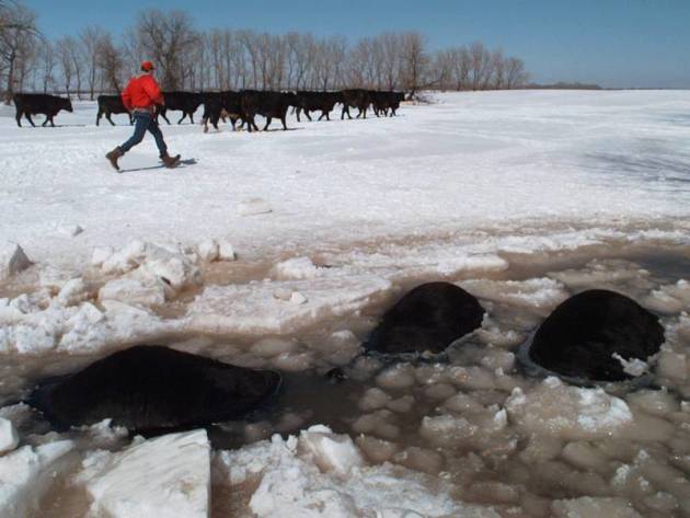
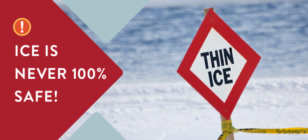
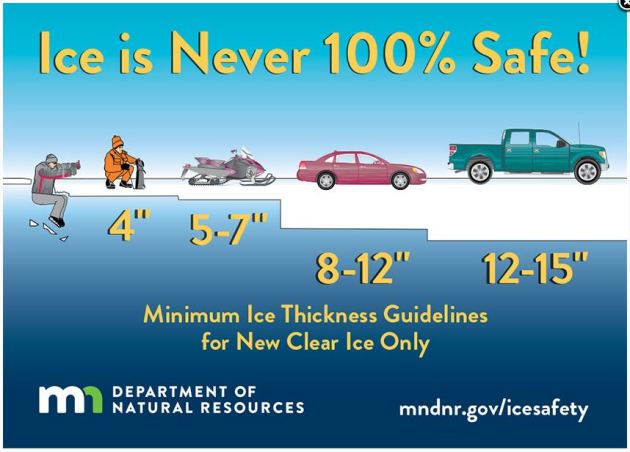
General Ice Thickness Guidelines

Here are some general ice thickness guidelines from the MN DNR:
For new, clear ice ONLY:

Under 4″ – STAY OFF
4″ – Ice fishing or other activities on foot
5″ – 7″ – Snowmobile or ATV
8″ – 12″ – Car or small pickup
12″ – 15″ – Medium truck

Many factors other than thickness can cause ice to be unsafe.
White ice or “snow ice” is only about half as strong as new clear ice. Double the above thickness guidelines when traveling on white ice.

See more from the MN DNR HERE:


___________________________________________________________________

Temperature Anomaly on Saturday
The image below shows the temperature anomaly across North America from Saturday which showed well below average temperatures across much of Canada and the eastern half of the country. However, note that the western and southwestern US was still WELL above average with temps running +10F to almost +20F above average.
 
Temperature Trend
Here’s the 850mb temperature anomaly from midday Saturday to Monday night, which suggests mild colder than average temperatures funneling south of the International border through the weekend and into early next week. However, warmer than average temperatures will continue in the Western and Southwestern US.
 
High Temps Sunday

High temps across the country on Sunday will be quite chilly again for much of the Midwest again with readings -10s to -20F below average. However, folks across Texas and the Western US will be well above average with temps running +10F to +20F above average.

_____________________________________________________________________________
Weather Outlook Ahead
Weather conditions through early Monday look fairly active across the northern tier of the nation with areas of rain and shovelable snow from the Northwest to the East Coast. Late weekend will be even more active as a larger storm develops east of the Mississippi River. Heavy rain and thunder will be possible in the Southeast, while shoveable and plowable snow will fall in the Northeast.
7 Day Precipitation Outlook

According to NOAA’s WPC, the 7-day precipitation outlook suggests areas of heavy precipitation continuing in the Northwest with several inches of precipitaiton from the Central and Northern Rockies to the northern Cascades. There will also be another batch of heavy precipitation in the Lower Mississippi Valley/Gulf Coast States through the early part of next weekend. There will also be areas of heavy precipitation across parts of the Northeast. Unfortunately, much of California and the Southwest will stay dry over the next 7 days.

Snowfall Potential Ahead

The snowfall potential through midweek suggests areas of heavy snow falling across parts of the central and northern rockies along with the northern Cascades. Lighter batches of snow will fall across parts of the Midwest, but heavier snow maybe possible across the Northeast over the next several days.
_____________________________________________________________________

Minnesota N-ICE; Coldest Super Bowl on Record
By Todd Nelson, filling in for Douglas.

I have to admit, I’ve been a little starstruck over the past few days. The amount of A-listers in town is staggering! I mean, Fallon eating hotdish in Champlin? JT at Target? How awesome is that? #Aardvark

The “Bold North” is buzzing and the culmination of Sunday’s big game will be enhanced by what will easily be THE coldest day in the 52 year Super Bowl history! Talk about Minnesota N-Ice.

Don’t adjust your TV screens, people really are turning 50 shades of blue in the Twin Cities today. Single digit temps and dangerously cold sub-zero wind chill values will test limits of this football frenzy town.

By the way, the last time Minneapolis hosted the Super Bowl was 26 years ago for Super Bowl 26! Guess what the high temp was that day… 26 degrees! Weird.

Between Saturday’s fluffy snow and Sunday’s face-numbing temperatures, I predict that it’ll be hard to leave without warm memories of “LII” in a land where an Uffda or a You Betcha is not uncommon.

Now, where’s the cheese dip and chicken wings?

BURP!  Excuse me…

________________________________________________________________________

Extended Forecast

SATURDAY NIGHT: Light snow ends early. Cold. Winds: N 5-10. Low:  -1 (Feels like: -15F to -20F).

SUNDAY: Coldest Super Bowl on record. Winds: WNW 10-15. High: 5. (Feels like: -10F to -15F)

SUNDAY NIGHT: Mostly clear and cold. Winds: WSW 5-10. Low: -2 (Feels like: -15F).

MONDAY: Sub-zero start. Snow develops late across far southern MN. Winds: WNW 5. High: 16.

TUESDAY: Sunny. Still cold. Winds: WSW 5. Wake-up: -2. High: 10.

WEDNESDAY: Another clipper. More light snow. Winds: SSW 5. Wake-up: -1. High: 16.

THURSDAY: Cold and quiet start. Snowy overnight. Winds: ENE 5-10. Wake-up: 6. High: 17.

FRIDAY: Shovelable snow? Strong PM winds develop. Winds: NW 15-30. Wake-up: 5. High: 15.

SATURDAY: Winds taper. Cold sunshine returns. Winds: SW 5-15. Wake-up: 2. High: 12.
_______________________________________________________

This Day in Weather History
February 4th

1984: The event termed the ‘Surprise Blizzard’ moves across Minnesota and parts of the Dakotas. Meteorologists were caught off guard with its rapid movement. People described it as a ‘wall of white.’ Thousands of motorists were stranded in subzero weather. Only a few inches of snow fell, but was whipped by winds up to 80 mph. 16 people died in stranded cars and outside.
_______________________________________________________

Average High/Low for Minneapolis
February 4th

Average High: 26F (Record: 51F set in 2005)
Average Low: 9F (Record: -28F set in 1886)

Record Rainfall: 0.34″ set in 1955
Record Snowfall: 4.4″ set in 1971
_________________________________________________________

Sunrise/Sunset Times for Minneapolis
February 4th

Sunrise: 7:29am
Sunset: 5:25pm

Hours of Daylight: ~9 hours & 56 minutes

Daylight GAINED since yesterday: ~ 2 minutes & 40 seconds
Daylight GAINED since winter solstice (December 21st): 1 Hour 10 Minutes
__________________________________________________________

Moon Phase for February 4th at Midnight
2.4 Days Before First Quarter Moon

_________________________

 Temp Outlook For Sunday

Temps on Sunday will be quite a bit cold across much of the region in the wake of a clipper system that dropped shovelable snow amounts in some areas on Saturday. Highs will be running a good -10F to -20F colder than average with wind chill values well into the sub-zero range. In fact, midday wind chills will still be quite dangerous for folks enjoying Super Bowl festivities in the Twin Cities.


 __________________________________________________________________________

8 to 14 Day Temperature Outlook

Here’s the temperature outlook as we head into the 2nd week of February, which suggests that warmer than average temperatures moving in across much of the Upper Midwest. It does appear that we may finally start easing out of the deep freeze by mid-month!

8 to 14 Day Temperature Outlook

As we head into the 2nd week of February, warmer than average temperatures will be in place across much of the western two-thirds of the nation. However, colder than average temperatures will still linger along the East Coast and across the Gulf Coast by mid-month.

____________________________________________________________________________
“Why You (Probably) Shouldn’t Worry About Earth’s Magnetic Poles Flipping”
“Earth’s magnetic poles, whatever they’re doing, are not going to spark chaos and kill us all — a scenario making the rounds online right now. According to the Australian news site news.com.au, a magnetic flip would not only cause massive blackouts, “even flushing the toilet could become impossible.” As reported by Undark, Daniel Baker, the director of the Laboratory for Atmospheric and Space Physics at the University of Colorado, Boulder, is suggesting a reversal would render parts of the planet uninhabitable (though Baker is not directly quoted saying this).”
 

________________________________________________________________________

“More Evidence That West Antarctica’s Glaciers Are in Terrible Shape”
“West Antarctica’s glaciers are the weakest link in the icy armor that surrounds the massive southern ice sheet. A study published in the Annals of Glaciology last month adds to the pile of crap news about how these glaciers, which extend out over water that’s being warmed by climate change, are susceptible to melting that could screw the world’s coasts. Scientists used a new technique to see how far water is intruding under West Antarctica’s Pine Island and Thwaites glaciers, two of the biggest and most vulnerable glaciers on Earth. They found signs that ocean water is pushing miles deeper under the ice than we realized in near a location where both glaciers meet, raising some uncomfortable prospects about how their futures could be intertwined.”
 

_________________________________________________________________________

“Meteorites Brought Water To Earth During the First Two Million Years”
“A new study of a rare basaltic meteorites called angrites suggests that volatiles, which are elements and molecules with relatively low boiling points such as water, could have been brought to our planet by meteorites during the first two million years of the Solar System. Since elements and molecules such as water and carbon are essential ingredients to life on Earth, researchers are keen to know when they arrived on our planet. “We’re looking at as many meteorite parent bodies as possible right now to figure out where they were in the early Solar System and how much water they had,” says Adam Sarafian, a recent doctoral graduate in the department of Earth, Atmospheric, and Planetary science at Massachusetts Institute of Technology. “We’re trying to build a map of the very early inner Solar System. Where was the water, where was it going and where did it come from?”
 

______________________________________________________________________________

“Polar Bears Wearing Cameras and Fitbits Reveal an Arctic Struggle for Survival”
“As Arctic sea ice disappears with global warming, polar bears will have a harder time catching seals. A new study shows how that puts their survival at risk. It’s not easy out there for a polar bear in the era of climate change, and according to a study released today, it’s even harder than previously thought. When scientists studied polar bears they had captured, outfitted with cameras and released, they found that the bears’ metabolism was 1.6 times higher than previously thought, making it harder for the animals to find enough food. In short: too many calories burned and not enough calories consumed.”
 

_________________________________________________________________________

“The Penguin and the Egg”
“This image of distant interacting galaxies, known collectively as Arp 142, bears an uncanny resemblance to a penguin guarding an egg. Data from NASA’s Spitzer and Hubble space telescopes have been combined to show these dramatic galaxies in light that spans the visible and infrared parts of the spectrum. This dramatic pairing shows two galaxies that couldn’t look more different as their mutual gravitational attraction slowly drags them closer together. The “penguin” part of the pair, NGC 2336, was probably once a relatively normal-looking spiral galaxy, flattened like a pancake with smoothly symmetric spiral arms. Rich with newly-formed hot stars, seen in visible light from Hubble as bluish filaments, its shape has now been twisted and distorted as it responds to the gravitational tugs of its neighbor. Strands of gas mixed with dust stand out as red filaments detected at longer wavelengths of infrared light seen by Spitzer.”
 

___________________________________________________________________________

“The West is in the middle of a serious snow drought”
“Snowpack is far below average, thanks to a combination of low precipitation and above-average temperatures.  Despite heading into the middle what is normally snow season, areas from Oregon to Nevada aren’t necessarily feeling the chill. Months of above-average temperatures and a slow start to the winter wet season have combined to leave much of the Western United States facing a snow drought, with snow levels in many places measuring less than a quarter of their historical average. Unlike its more familiar meteorological cousin, a snow drought doesn’t necessarily mean that no precipitation is falling. But in places like Oregon, warmer temperatures mean that precipitation this year has largely fallen as rain — an ominous sign for the region’s winter economy, and a worrying harbinger of a potentially water-scarce spring and summer.”

______________________________________________________________________________

“The Slick Science of Making Olympic Snow and Ice”
“One of the more crucial components -and often the most overlooked by spectators- is the ice and snow under the performing athletes. The Games cannot rely on the weather providing the required conditions for skiing, skating, and sledding. And the quality of the ice and snow is important for the fastest races and the most intricate stunts. Bumps on a bobsled run? They’ll not only ruin an Olympic race, they’re also dangerous. Tracy Seitz of Whistler Sliding Centre in Canada explains the intricacies of Olympic ice. The ice for indoor rinks is built to different standards for speed skating, figure skating, curling, and hockey. And the snow under skiers and snowboarders is engineered for speed as well, with the added difficulty of dealing with the vagaries of actual weather. Read about the different kinds of snow and ice and how they are created for the Olympics at Smithsonian.”

_______________________________________________________________________________
“Mega Cities Poised to Become the Hottest and Most Dangerous Places Under Climate Change”
“RISING TEMPERATURES It’s no secret that temperatures around the world are rising. 2017’s record temperatures, prolific hurricane season, and heavy rainfall prompted the World Economic Forum to predict that extreme weather would be the biggest threat in 2018. A team of researchers from the University of California, Irvine analyzed data from 9,000 weather stations around the world and determined the global temperature has increased by 0.19 degrees Celsius each decade for the last 50 years. They also noted that the increase was even more pronounced in the last 30 years — a 0.25 degree-increase each between 1986 and 2015.”
 

 ___________________________________________________________________________

“Understanding Diurnal Temperature Range”
“How the Atmosphere Heats and Cools During a 24-Hour Period. All things in nature have a diurnal or “daily” pattern simply because they change throughout the course of a day. In meteorology, the term “diurnal” most often refers to the change of temperature from the daytime high to the nighttime low. Why Highs Don’t Happen at High Noon The process of reaching a daily high (or low) temperature is a gradual one. It begins each morning when the Sun rises and its rays extend toward and strike the Earth’s surface. Solar radiation directly heats the ground, but because of land’s high heat capacity (ability to store heat), the ground doesn’t immediately warm. Just as a pot of cold water must first warm before coming to a boil, so must the land absorb a certain amount of heat before its temperature rises. As the ground’s temperature warms, it heats a shallow layer of air directly above it by conduction. This thin layer of air, in turn, heats the column of cool air above it.”
 

 _______________________________________________________________________________

“How Australian trees beat extreme heat by sweating”

“Researchers from Western Sydney University have uncovered the novel strategies Australian eucalypt trees use to survive extreme heatwaves. One remarkable process involves the tree evaporating large volumes of water through its leaves in a process is similar to sweating. The study involved the University’s novel Whole Tree Chambers, which give researchers the ability to grow trees up to a height of 9 m (29.5 ft) in fully enclosed and controllable environments that allow air temperature, soil moisture, irrigation, CO2 levels and humidity to be manipulated. Six Parramatta Gums (Eucalyptus parramattensis) were grown in the chambers for 12 months under conditions simulating an average of 3° C (5.4° F) warmer than average, while six were grown under ambient temperature conditions.”

See more from New Atlas HERE:


 ______________________________________________________________________________

Thanks for checking in and don’t forget to follow me on Twitter @TNelsonWX