The Weather Blog
Daily weather updates
Grinding Through A Frigid Start to February

___________________________________________________________________________
.gif)
.png)


__________________________________________________________________________

February Temperature & Precipitation Outlook
Here’s NOAA’s February temperatures and precipitation outlook, which suggests that colder and wetter than average conditions will be found across the northern tier of the nation and especially from the Midwest to the Northeast. However, warmer and drier than average conditions look to continue across the southern and western US.


____________________________________________________________________________


____________________________________________________________________________
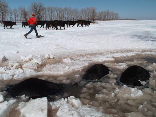
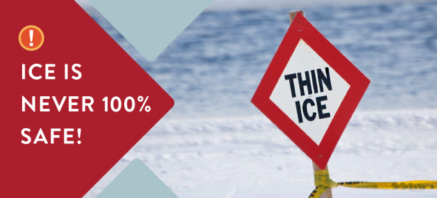
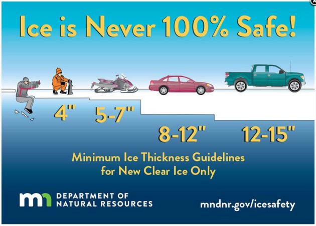
General Ice Thickness Guidelines
Under 4″ – STAY OFF
4″ – Ice fishing or other activities on foot
5″ – 7″ – Snowmobile or ATV
8″ – 12″ – Car or small pickup
12″ – 15″ – Medium truck
Many factors other than thickness can cause ice to be unsafe.
White ice or “snow ice” is only about half as strong as new clear ice. Double the above thickness guidelines when traveling on white ice.
___________________________________________________________________
.png)

High temps across the country on Monday will be quite chilly again for much of the Midwest again with readings -10s to -20F below average. However, folks across the Western US will be well above average with temps running +10F to +20F above average.


.gif)
According to NOAA’s WPC, the 7-day precipitation outlook suggests areas of heavy precipitation continuing in the Northwest with several inches of precipitaiton from the Central and Northern Rockies to the northern Cascades. There will also be another batch of heavy precipitation in the Lower Mississippi Valley/Gulf Coast States through next weekend. There will also be areas of heavy precipitation across parts of the Northeast. Unfortunately, much of California and the Southwest will stay dry over the next 7 days.
.gif)
Snowfall Potential Ahead
.png)
Grinding Through A Frigid Start to February
By Todd Nelson, filling in for Douglas.
OK, be honest. As a Minnesotan, raise your hand if you told any of your visiting friends that yesterday’s cold weather was a typical winter day here in the “Bold North”? I don’t know about you, but I enjoyed the Arctic air a lot more while staring at it inside through a window.
Super Bowl Sunday’s weather was easily THE coldest on record in its 52 year history. The high temperature? Just above zero degrees! Feels like temps stayed in the teens and twenties below zero, which made for an extremely painful “LII” celebration. Sub-zero sunshine is a sensation. Equivalent to getting a cavity filled while staring into the bright light from a dentist chair… Think about it!
Minnesota really is the Super Bowl of weather. From blizzards to tornadoes and just shy of hurricanes, we get it all. Come visit in July when our heat index surges into the triple digits. Really!
It’ll be another chilly week with highs in the teens and sub-zero wind chills. Light snow sails across far southern MN twice this week. We finally thaw out mid-Feb.
________________________________________________________________________
Extended Forecast
MONDAY: Sub-zero start. Snow develops late across far southern MN. Winds: WNW 5. High: 16.
MONDAY NIGHT: Mostly clear and cold. Winds: NW 5. Low: -6. (Feels like: -15F to -20F)
TUESDAY: Cold sun. Light snow overnight. Winds: SSW 5-10 High: 8.
WEDNESDAY: Slightly warmer. Yea, still cold. Winds: WNW 5. Wake-up: 2. High: 17.
THURSDAY: Clouds thicken. Snow late in southern MN. Winds: NNE 5. Wake-up: -1. High: 12.
FRIDAY: Chance of light snow, mainly south. Winds: NE 5-10. Wake-up: 1. High: 13.
SATURDAY: Light snow. Light snow accumulations? Winds: NNE 5-15. Wake-up: -2. High: 14.
SUNDAY: Brighter blue sky. Winds: WNW 5-10. Wake-up: 4. High: 16.
_______________________________________________________
This Day in Weather History
February 5th
1834: Unseasonably mild temperatures are felt at Ft. Snelling with a high of 51.
_______________________________________________________
Average High/Low for Minneapolis
February 5th
Average High: 26F (Record: 51F set in 2005)
Average Low: 10F (Record: -27F set in 1979)
Record Rainfall: 0.52″ set in 1908
Record Snowfall: 7.5″ set in 1908
_________________________________________________________
Sunrise/Sunset Times for Minneapolis
February 5th
Sunrise: 7:27am
Sunset: 5:27pm
Hours of Daylight: ~9 hours & 59 minutes
Daylight GAINED since yesterday: ~ 2 minutes & 42 seconds
Daylight GAINED since winter solstice (December 21st): 1 Hour 13 Minutes
__________________________________________________________
Moon Phase for February 5th at Midnight
1.4 Days Before First Quarter Moon
.gif)
_________________________
Temp Outlook For Monday


__________________________________________________________________________
Here’s the temperature outlook as we head into the 2nd week of February, which suggests that warmer than average temperatures moving in across much of the Upper Midwest. It does appear that we may finally start easing out of the deep freeze by mid-month!

8 to 14 Day Temperature Outlook
As we head into the 2nd week of February, warmer than average temperatures will be in place across much of the Western US and into the Upper Midwest. However, colder than average temperatures will be in place across the Southern US.


_______________________________________________________________________________

_____________________________________________________________________________

___________________________________________________________________________

_____________________________________________________________________________

_____________________________________________________________________________

________________________________________________________________________

_________________________________________________________________________

_________________________________________________________________________

___________________________________________________________________________
Thanks for checking in and don’t forget to follow me on Twitter @TNelsonWX

Read Paul’s New Book
Caring for Creation: The Evangelical’s Guide to Climate Change and a Healthy Environment