The Weather Blog
Daily weather updates
At Least We Don’t Get Hurricanes – Thaw Shaping Up for Next Week

Take a bow. Whether you realize it or not YOU are a weather warrior. Most Super Bowl fans were exuberant about the warm welcome they got in Minnesota, but a few poor souls were traumatized by our single-digit highs.

Super Bowl of Cold. A story at The Chicago Tribune made me laugh; here’s an excerpt: “…The cold was just brutal,” said Philadelphia Eagles fan Terry Laufer of Carrollton, Virginia. His wife, Rhonda, said: “I would never be able to bring children here. It would be too risky.” The pair said they’d return with their grandkids in September, when it’s warmer. “You could have had the Arctic Circle and it would have been a great experience,” said Jody Haggerty of Milford, Pennsylvania. “Minneapolis made it work. … It’s not about the location. It’s about the experience, the atmosphere and the game.”


The degree to which Arctic air penetrates into middle latitudes is related to the AO index, which is defined by surface atmospheric pressure patterns. When the AO index is positive, surface pressure is low in the polar region. This helps the middle latitude jet stream to blow strongly and consistently from west to east, thus keeping cold Arctic air locked in the polar region. When the AO index is negative, there tends to be high pressure in the polar region, weaker zonal winds, and greater movement of frigid polar air into middle latitudes.” [3]


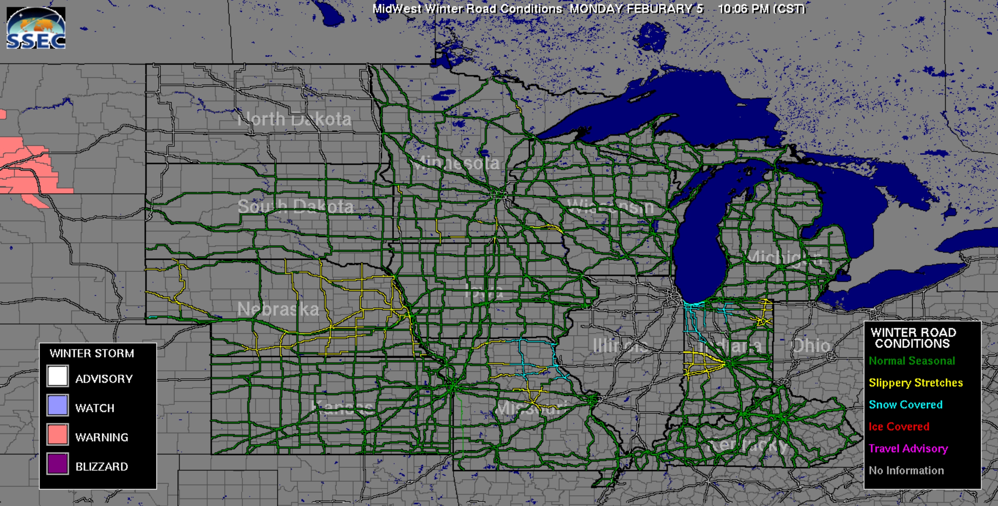
Public Domain Source of Road Conditions. If you’re interested in latest road conditions check out the SSEC site, courtesy of the University of Wisconsin.
Praedictix Briefing: Issued Tuesday night, February 6th, 2018:
-Ice Storm Warnings are in effect for northern Arkansas and southeastern Missouri through 6 AM Wednesday. Up to a third of an inch of ice will be possible.
-Widespread freezing rain will impact the Ozarks, the Ohio Valley and extend into the Mid Atlantic. Some locations are expected to receive over a quarter inch of freezing rain, especially along the Ohio Valley and Central Appalachia.
-Winter Storm Warnings are in effect in the interior northeast as heavy snow is projected for the area Wednesday. Snowfall rates up to 2” an hour will be possible with widespread amounts between 5 and 10 inches.

Credit: AerisWeather
Winter Weather Alerts. Ice Storm Warnings, Winter Weather Advisories and Winter Storm Warnings have been issued from the Central US into the Northeast. A significant icing event is expected from the Central Mississippi Valley through the Ohio Valley and the Central Appalachians. Heavy snow is expected for the interior Northeast with 5 to 10 inches of snow possible through Wednesday night/early Thursday.


Freezing Rain Threat. A southern track storm with generous amounts of moisture will interact with cold Canadian air. In many cases, temperature profiles are not cold enough for all snow and show a significant sleet/freezing potential. Those along the Ohio Valley and Central Appalachians have the greatest risk of seeing up to a quarter inch of ice. Not only will dangerous travel conditions unfold overnight, but power outages will also be a possibility. A light coating of ice will also be possible into the Northeast. In combination with snow accumulations, this will be a high-impact event for road travel in the affected areas.


Heavy Snow Expected. While some snow is forecast to fall north of the storm’s frontal boundaries, the heaviest snow is projected for the interior Northeast with total accumulations likely ranging between 5 and 10 inches. Snow rates up to 2 inches an hour will be possible, reducing visibility. Weather conditions will rapidly deteriorate in the Northeast throughout the day Wednesday. Rain is mainly expected along the I-95 corridor to NYC, which cuts down on the snow amounts for the larger metropolises. However, a wintry mix might be possible in Philadelphia and the D.C. metro area Wednesday morning.


Precipitation Timing. Conditions are deteriorating tonight for the Ozarks and the Ohio Valley. By early Wednesday morning, ice will have been accumulating to up to a tenth or more for part of the Ohio Valley impacting cities like Louisville and Cincinnati. The storm will continue to track into the northeast. Heavy snow will begin to push into the interior Northeast by early Wednesday and will continue to spread throughout the region as the day progresses. Precipitation will push out of the region by Wednesday night as the storm accelerates into the Canadian maritimes.
Summary. A high-impact winter weather event is unfolding tonight with significant icing projected from the Ozarks, the Ohio Valley and Central Appalachia, where up to a quarter inch of ice will be possible. Not only will travel become dangerous, power outages will also be a possibility. Snow will also accumulate for these locations, but Midwestern snow totals are modest. The interior Northeast is where we expect more impressive totals. Heavy snow will spread throughout the Northeast dumping up to 10 inches of snow. Major Northeast cities such as NYC and DC look to be spared of the worse, though a wintry mix in the morning and a light coating of snow will be possible. Boston may see up to 5 inches or so.
Susie Martin, Meteorologist, Praedictix.

Quietest Winter for Severe Weather in 14 Years. Here’s an excerpt from Weather Underground: “Severe thunderstorms and tornadoes usually take a back seat in winter in most of the United States, but it has been more than a decade since we’ve seen such a lack of severe weather, even in the Deep South during the winter months, according to data from NOAA. The December-through-January two-month stretch generated only 154 reports of severe weather, including 29 reports of tornadoes, 20 reports of large hail and 105 reports of damaging or high thunderstorm winds in the U.S., according to preliminary data provided by Dr. Patrick Marsh, warning coordination meteorologist at NOAA’s Storm Prediction Center. That seems like a lot of severe weather for winter, but according to the SPC data, it’s the least amount of U.S. severe weather in any December-through-January period in 14 years, when December 2003 through January 2004 featured a paltry 96 reports…”

IMPACTS: Headlines and links courtesy of Climate Nexus: “Floods are getting worse, and 2,500 chemical sites lie in the water’s path (New York Times $), California bakes as winter temperatures set new records across the state (LA Times $), after deadly mudslides in California, residents are trying to plan for next time (NPR), the hurricane hit Puerto Rico’s paradise of hotels and resorts hard — and workers are facing an uncertain future (Buzzfeed), how Florida plans to fix hurricane evacuation routes.” (Miami Herald).
File image: U.S. Coast Guard.


Despite Polar Progress, Ozone Layer Continues to Deteriorate. Here’s an excerpt from Cosmos Magazine: “Pointing to the recovery of the ozone layer as humanity’s one great triumph of environmental remediation may have been premature, a new report warns. A team led by Joanna Haigh of the Grantham Institute at Imperial College London, UK, has discovered that while ozone density is indeed improving at the poles, it is not doing so at lower latitudes, roughly between 60 degrees north and 60 degrees south. That encompasses everywhere on the planet between the Shetland Islands off the north coast of Scotland to south of Tierra del Fuego at the foot of South America. The researchers found that although the decrease in ozone concentration is not as great as that seen at the poles before the banning of ozone-depleting chlorofluorocarbons (CFCs) in 1987, the effects may be worse, because ultraviolet radiation is stronger in the region, and it contains most of the world’s population…”
Image credit: “A colored satellite map of atmospheric ozone in the southern hemisphere between mid-August and early October 1998. An ozone “hole” is seen over Antarctica.” NASA/SCIENCE PHOTO LIBRARY.

Hot Tea Linked to Esophageal Cancer in Smokers, Drinkers. Here’s an excerpt from CNN: “If you smoke cigarettes or drink alcohol daily, you may want to consider letting your tea cool before you enjoy it. Drinking tea while it’s too hot could increase your risk of esophageal cancer, a new study suggests. In the study, published Monday in the Annals of Internal Medicine, drinking “hot” or “burning hot” tea was associated with a two- to fivefold increase in esophageal cancer, but only in people who also smoked or drank alcohol. Esophageal cancer is the eighth most common cancer in the world and is often fatal, killing approximately 400,000 people every year, according to the International Agency for Research on Cancer. It is usually caused by repeated injury to the esophagus due to smoke, alcohol, acid reflux and — maybe — hot liquids…”

Test Alert of Tsunami Warning for Houston Accidently Sent as Push Notification. Another glitch in the matrix, it seems, according to The Houston Chronicle: “Houstonians who were warned about a tsunami coming for the Gulf coast Tuesday have no reason to panic. The National Weather Service for Houston and Galveston acknowledged Tuesday that a tsunami threat was sent out around 7:30 a.m. CDT. That warning was a test however, and wasn’t meant to be sent out to people. People along the Gulf weren’t the only ones to get the alert. NOAA sent the same warning to the east coast, leaving other NWS posts to dismiss the tsunami threat…”
5″ snow on the ground at Twin Cities International Airport.
10 F. high on Tuesday.
26 F. average high in the Twin Cities on February 6.
33 F. high on February 6, 2017.
February 7, 1857: A snowstorm dumps around 9 inches of snow at Fort Snelling.


WEDNESDAY: Icy start, then clearing skies. Winds: NW 5-10. High: 15
WEDNESDAY NIGHT: Partly cloudy. Low: 3
THURSDAY: Sunny start, light snow late PM hours. Winds: N 3-8. High: 16
FRIDAY: Slick early, then the sun comes out. Winds: N 5-10. Wake-up: 2. High: 10
SATURDAY: Patchy clouds, chance of flurries. Winds: E 5-10. Wake-up: 0. High: 13
SUNDAY: Partly sunny, still brisk. Winds: NW 7-12. Wake-up: 2. High: 15
MONDAY: Clouds increase, not as harsh. Winds: SE 10-15. Wake-up: 8. High: 25
TUESDAY: Some sun. Happy to see average temperatures. Winds: NW 5-10. Wake-up: 14. High: 27
Climate Stories…

Permafrost Could Unlock Enormous Levels of Mercury: From Climate Nexus: “Enormous levels of mercury could be released into the atmosphere if Arctic permafrost thaws, new research shows. A study published Monday in the journal Geophysical Research Letters analyzes mercury cores drilled from permafrost in northern Alaska and finds that the permafrost holds twice the amount of mercury as is stored in all other soils, the atmosphere and the world’s oceans combined. “As permafrost thaws in the future, some portion of this mercury will get released into the environment, with unknown impact to people and our food supplies,” study co-author Kevin Schaefer told the Washington Post.” (Washington Post $, UPI, Alaska Native News)
File image: USGS.

A Trip to a Museum for Convincing Americans About Climate Change. Here’s a clip from a story at The Atlantic: “…The exhibition is the inaugural show of the country’s first climate museum. Housed at the Parsons School of Design, the museum—for now—only consists of the gallery on the corner of 13th Street and Fifth Avenue. After garnering a lot of attention when its founding director Miranda Massie announced the museum’s incorporation in 2015, its first public offering has opened with little fanfare. This is in part because Massie is testing the potential audience for the museum, but also because she’s experimenting with the delicate balance of its content. When she was introduced to Weil through a friend and saw images of 88 Cores, she thought it would not only complement the airy confines of the Parsons gallery, but would also, more importantly, affect people emotionally…”
Photo credit: “‘Whale Bay, Antarctica No.4,’ soft pastel on paper.” Zaria Forman.

Polar Vortex: How the Jet Stream and Climate Change Bring on Cold Snaps. Because what happens in the arctic doesn’t stay in the arctic. A story at InsideClimate News explains how a rapidly warming arctic may be altering the jet stream: “…Rutgers University climate scientist Jennifer Francis has found “robust relationships” between Arctic warming and a wavier jet stream. Melting sea ice speeds up the warming of the Arctic because open water absorbs more heat. And that, in turn, leads to even more sea ice melting. In that vicious cycle, Arctic temperatures are rising twice as fast as the global average. And that’s reducing the temperature contrast that’s one of the jet stream’s main engines, Francis said. More extreme and persistent swings in the jet stream may also be shaping a North American winter weather pattern that’s been common the past few years—a warm and dry West, especially California, and cold waves in the Eastern U.S…”

ExxonMobil Issues Climate Report: From Climate Nexus: “World demand for oil could dip substantially by 2040 if policies to curb warming are aggressively implemented, ExxonMobil said in a climate-impact analysis released Friday. The oil giant’s shareholders, including financial giants BlackRock and Vanguard, backed a proposal last year requiring Exxon to provide analysis of how climate policies will impact its bottom line in an increasingly warming world. The analysis paints a mostly rosy future for the oil and gas industry, saying that even aggressive climate policy poses “little risk” to the company. However, the report does not address the multiple lawsuits facing Exxon and other fossil fuel giants, while some of the company’s analysis–including its predictions for the number of electric vehicles on the road by 2040 and the assumption that carbon capture technologies will allow the continued use of fossil fuels–has been challenged by experts.” (New York Times $, FT $, Reuters, AP, Axios, Quartz, The Hill)

Study Confirms Carbon Pollution Has Ended the Era of Stable Climate. ThinkProgress reports: “Recent temperatures experienced across Europe and North America are unprecedented in the past 11,000 years, a new study in the journal Nature finds. Significantly, the new study found that the average temperature of the last decade (between 2007 and 2016) exceeded the warmest centuries of the last 11,000 years by more than 0.5°F — which is much larger than century-scale changes have been over the pre-industrial era. This research confirms findings from 2013 that human-caused carbon pollution has ended the stable climate that enabled the development of modern civilization, global agriculture, and a world that could sustain a vast population…”
Chart credit above: “Temperature change over past 11,000 years (in blue) plus projected warming over the next century on humanity’s current emissions path.”

Record Number of Scientists Running for Office in 2018. Here’s a clip from TheHill: “At least 200 individuals with backgrounds in science, math, engineering and technology have launched bids for state House seats across the country, according to HuffPost. The number marks the largest number of scientists to run for office in modern history. The PAC 314 Action told the outlet that the candidates were running in elections for 7,000 state legislature seats. “The sheer number is really astonishing,” the group’s founder, Shaughnessy Naughton, told the outlet. The PAC’s membership expanded from 4,000 to 400,000 in 2017…”
Read Paul’s New Book
Caring for Creation: The Evangelical’s Guide to Climate Change and a Healthy Environment