The Weather Blog
Daily weather updates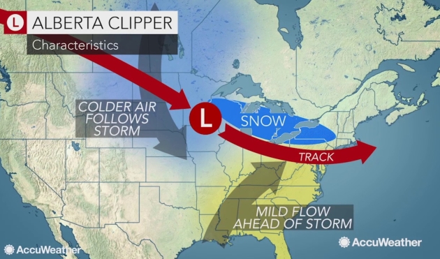
Clipped by a Clipper – Hints of March in Extended Outlook

What’s an Alberta Clipper and Why Should I Care?
“Paul, why are you doing commercials for a barber in Edmonton?” Huh. “All this talk of Alberta Clippers – is this a chain or a franchise?” Let me explain.
Alberta Clippers are small, fast-moving storms that approach from the direction of Alberta, Canada. They’re called clippers because they can move as fast as 30 mph, similar to the clipper ships of the 1800s, the fastest vessels on the seas at that time.
Our biggest storms approach from the southwest, brimming with moisture from the Gulf of Mexico. That’s how 12.4 inches fell on January 22. Oh happy day. Clippers tend to whip up a few inches of powder, prone to blowing and drifting. They are cold storms, so even an inch at 5F can be problematic, since salt doesn’t melt ice when it gets that cold.
One such clipper brushes southern Minnesota with a couple inches of fluff tonight – closer to 3-6 inches near Chicago. No big, sloppy, southern headline-worthy storms are brewing here anytime soon.
We’ve picked up 79 minutes of daylight since December 21. A thaw is now likely next week; maybe 40F the weekend of February 17-18.

Beefier Clipper. The next surge of low pressure sideswipes southern Minnesota with a few inches of snow; a little over 1″ predicted for the Twin Cities metro. If you’re traveling toward Milwaukee, Chicago or Detroit you may encounter more significant amounts, and delays by tonight and early Friday. 12km NAM guidance: NOAA and tropicaltidbits.com.


Not as Cold. There’s still a fair amount of back and forth with GFS guidance at 500mb. Then again we’re looking out nearly 2 weeks – strong jet stream winds unstable and hard to pin down with a high confidence level this far out. Latest models hint at a milder, somewhat more Pacific flow for the USA with a longwave trough dragging a stormy front front into the Upper Midwest by the evening of February 21.


Praedictix Briefing: More Heavy Snow for Chicago Area. Briefing issued Wednesday, February 7th, 2018:
* Snow and ice is falling across parts of the Ohio Valley and the Northeast this morning, with significant ice and heavy snow accumulations already reported in parts of Ohio and Pennsylvania.
* Numerous Winter Weather Advisories and Winter Storm Warnings continue from the Ohio Valley to New England this morning for the potential of ice and snow. Additional ice accumulations of 0.05″-0.25″ are possible, especially across southeastern Ohio, southern Pennsylvania, northern Maryland and northern Virginia, which will make travel difficult. The heaviest snow will fall across the interior Northeast with accumulations of up to a foot expected.
* Another system will impact Chicagoland late Thursday into Friday, bringing the potential of 5-9″ of snow. Winter Storm Watches are already in effect for this snow potential.

Morning Radar. Snow and ice continues to fall from the Ohio Valley into parts of the Northeast as of early Wednesday morning. Already freezing rain amounts of up to 0.30″ have been reported across parts of Ohio, with freezing rain reported as far east as Philadelphia. Snow totals across Ohio and Pennsylvania have also totaled up to around 5″, with isolated 7″ amounts in western Pennsylvania.
Local Department of Transportation Websites:
Missouri: http://traveler.modot.org/
Illinois: https://www.gettingaroundillinois.com/WinterConditions/index.html
Indiana: http://indot.carsprogram.org/
Kentucky: http://goky.ky.gov
Ohio: http://www.ohgo.com
Pennsylvania: http://www.511pa.com

Winter Weather Alerts. Numerous Winter Weather Advisories and Winter Storm Warnings continue this morning from the Ohio Valley to the Northeast. A mixture of ice and snow is expected from the Ohio Valley across parts of the Northeast and New England, with between 0.05″-0.20″ of ice possible. Heavy snow is expected across the interior Northeast with the potential of 5-12″ of snow through tonight. Winter Storm Watches are in effect across the Chicagoland area for late Thursday into Friday for the potential of 5-9″ of heavy snow.

Ice Potential. We’ll continue to watch temperature profiles that won’t be cold enough for all snow at times, bringing the potential of freezing rain and sleet from the Ohio Valley to parts of the Northeast. The heaviest ice today is expected to fall across southeastern Ohio, southern Pennsylvania, northern Maryland and into northern Virginia, where additional ice accumulations of 0.10″-0.25″ are expected. This would bring difficult travel conditions, and even the potential of power outages.

Snow Expected. The heaviest snow is expected across the interior Northeast, where snowfall amounts of up to a foot are expected. Snowfall rates of up to 2″ per hour can be expected in the heaviest snow, greatly reducing visibility and making travel hazardous across the region. The heaviest snow is expected to mainly fall outside the large metropolitan areas, with only 2-4” of additional snow expected for Pittsburgh and Boston.

Precipitation Timing. The storm will continue to spread across the Northeast today, bringing the potential of rain, snow and ice with it. This system will push out of the region tonight, with most areas seeing no precipitation by the Thursday morning commute.

A Second System To Impact Chicago Thursday–Friday. Another system is expected to impact the Chicago area later this week with heavy snow. Snow is expected to start Thursday Night across the region, lasting into Friday, with the heaviest snow falling between Midnight Thursday Night and Noon Friday. Overall snow totals of 5-9″ are expected across the region. Due to the potential of heavy snow, Winter Storm Watches are in effect. This snow will have major impacts on both the morning and evening commutes Friday across Chicagoland.
Summary. Snow and ice will continue to fall from the Ohio Valley to the Northeast today, with ice accumulations of up to a quarter inch and snow across the interior Northeast of up to a foot possible. This will cause travel disruptions across the region today into tonight. The precipitation will be offshore by the Thursday morning commute. Numerous Winter Weather Advisories and Winter Storm Warnings are in effect for this system. A second system will impact the Chicagoland area late Thursday into Friday, bringing the potential of 5-9″ of snow. Winter Storm Watches have been put in place due to this late week snow threat.
D.J. Kayser, Meteorologist, Praedictix

Super Bowl of Cold. A story at The Chicago Tribune made me laugh; here’s an excerpt: “…The cold was just brutal,” said Philadelphia Eagles fan Terry Laufer of Carrollton, Virginia. His wife, Rhonda, said: “I would never be able to bring children here. It would be too risky.” The pair said they’d return with their grandkids in September, when it’s warmer. “You could have had the Arctic Circle and it would have been a great experience,” said Jody Haggerty of Milford, Pennsylvania. “Minneapolis made it work. … It’s not about the location. It’s about the experience, the atmosphere and the game.”


Quietest Winter for Severe Weather in 14 Years. Here’s an excerpt from Weather Underground: “Severe thunderstorms and tornadoes usually take a back seat in winter in most of the United States, but it has been more than a decade since we’ve seen such a lack of severe weather, even in the Deep South during the winter months, according to data from NOAA. The December-through-January two-month stretch generated only 154 reports of severe weather, including 29 reports of tornadoes, 20 reports of large hail and 105 reports of damaging or high thunderstorm winds in the U.S., according to preliminary data provided by Dr. Patrick Marsh, warning coordination meteorologist at NOAA’s Storm Prediction Center. That seems like a lot of severe weather for winter, but according to the SPC data, it’s the least amount of U.S. severe weather in any December-through-January period in 14 years, when December 2003 through January 2004 featured a paltry 96 reports…”
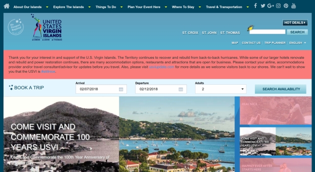
US Virgin Islands Facing Daunting Recovery: From Climate Nexus: “A lackluster disaster relief response from Congress could decimate a developing middle class in the hurricane-ravaged US Virgin Islands, the Washington Post reported Tuesday. Virgin Islands residents, many of whom profited from a tourism boom beginning in the ’90s, say that Hurricanes Maria and Irma wiped out their homes and livelihoods, while a slow recovery and largely underinsured assets have made it nearly impossible to rebuild their lives over four months later. The Post reports that the territory’s lack of voting representation in Congress “[reinforces] disconnect from the mainland” during recovery and worries officials who say the island needs $7.5 billion in aid from the federal government. NPR reported last week that even as tourists begin to return, hospitals and health services on the islands remain in a “critical state.” (Rebuilding: Washington Post $. Healthcare: NPR)
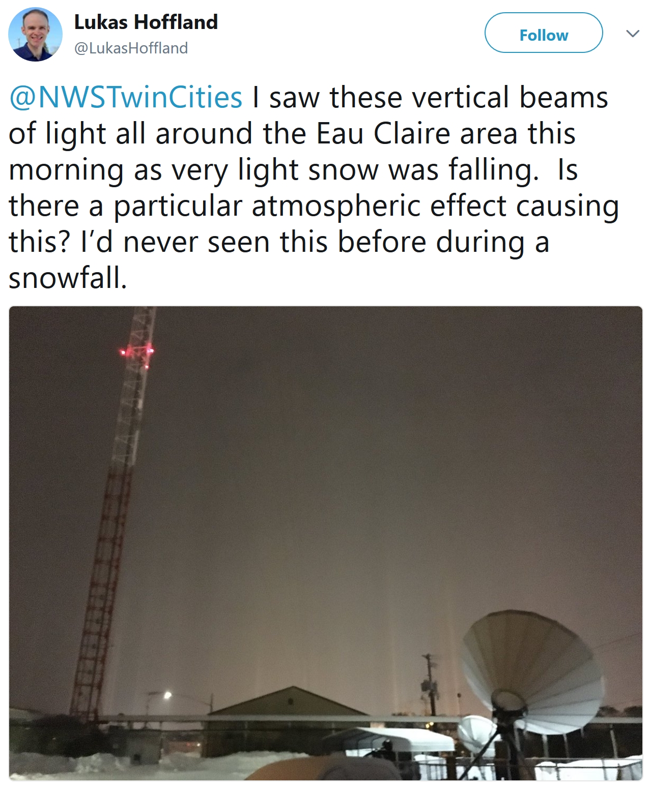
Light Pillars. Here’s a good explanation from NOAA: “Long pillars of multicolored light streaking the sky seem like the perfect backdrop for impending alien invasion, but in reality, light pillars are a common effect that can be found all over the world. They do come from above — not extraterrestrials, but tiny crystals of ice hanging in the atmosphere. Ice is very thin, shaped like plates with hexagonal faces. When ice drifts down through the air, it falls close to horizontally. At the top and bottom are the faces with more area. Ice is very reflective, so when light hits those wider faces, it bounces around and reflects off more ice crystals. That means we get these vertically stacked mirrors floating in the atmosphere. The light hitting it gets reflected up and up (or down and down, depending on the source), and becomes a radiant column in the sky. Light can come from the sun, moon, cities, street lights — any strong light source.”

Despite Polar Progress, Ozone Layer Continues to Deteriorate. Here’s an excerpt from Cosmos Magazine: “Pointing to the recovery of the ozone layer as humanity’s one great triumph of environmental remediation may have been premature, a new report warns. A team led by Joanna Haigh of the Grantham Institute at Imperial College London, UK, has discovered that while ozone density is indeed improving at the poles, it is not doing so at lower latitudes, roughly between 60 degrees north and 60 degrees south. That encompasses everywhere on the planet between the Shetland Islands off the north coast of Scotland to south of Tierra del Fuego at the foot of South America. The researchers found that although the decrease in ozone concentration is not as great as that seen at the poles before the banning of ozone-depleting chlorofluorocarbons (CFCs) in 1987, the effects may be worse, because ultraviolet radiation is stronger in the region, and it contains most of the world’s population…”
Image credit: “A colored satellite map of atmospheric ozone in the southern hemisphere between mid-August and early October 1998. An ozone “hole” is seen over Antarctica.” NASA/SCIENCE PHOTO LIBRARY.

In 2017 U.S. Lost Nearly 10,000 Solar Jobs. Here’s an excerpt from The Atlantic: “Since the end of the Great Recession, two things have been true of the American solar industry: It was growing like gangbusters, and basically everyone liked it. From 2010 to 2016, the number of solar jobs in the United States nearly tripled, roaring from about 93,000 to more than 260,000. In 2016 alone, the solar industry grew 17 times faster than the U.S. economy. By the end of that year, there weren’t only more solar workers than coal miners; there were more people working in the solar industry than were employed by every oil, gas, and coal-burning power plant put together…”
Photo credit: Bruno Kelly / Reuters.
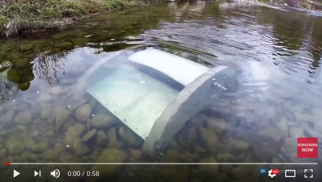
What the Heck is a “Waterrotor”? Energy from flowing streams? Why now. Check out the details: “Accessible and affordable electricity is a major global issue. 1.3 billion people are without electricity, and over 800 million people depend on high cost, polluting fossil fuel generators for their power. However, over 71% of the planet is covered with slowly moving water in rivers, canals, and ocean currents. A huge, untouched global market exists to provide electricity where it is unavailable, and also to replace the millions of fuel-burning generators currently supplying power at very high cost...”
YouTube has a video of how the Waterrotor works here.


Job Automation Will Hurt Women First But Will Ultimately Hurt Men More. The long-range forecast calls for disruption, according to a story at Quartz: “…Across all age groups, women could be displaced first due to the larger numbers of women in clerical positions in different industries. But at a broader level, women are more concentrated in sectors such as education and health, which require more personal and social skills that are less easily automated (for now). All this being said, PwC’s estimates are based on the technical feasibility of automation. In reality, economic, legal, regulatory, or organizational constraints could limit the true impact. Because public policy will likely be needed to offset the inequitable impact of automation, with less-educated people hurt the most, this could also slow the technological progress…”
Photo credit: “Looks innocent.” (Reuters/Jason Lee)

Hot Tea Linked to Esophageal Cancer in Smokers, Drinkers. Here’s an excerpt from CNN: “If you smoke cigarettes or drink alcohol daily, you may want to consider letting your tea cool before you enjoy it. Drinking tea while it’s too hot could increase your risk of esophageal cancer, a new study suggests. In the study, published Monday in the Annals of Internal Medicine, drinking “hot” or “burning hot” tea was associated with a two- to fivefold increase in esophageal cancer, but only in people who also smoked or drank alcohol. Esophageal cancer is the eighth most common cancer in the world and is often fatal, killing approximately 400,000 people every year, according to the International Agency for Research on Cancer. It is usually caused by repeated injury to the esophagus due to smoke, alcohol, acid reflux and — maybe — hot liquids…”

Test Alert of Tsunami Warning for Houston Accidently Sent as Push Notification. Another glitch in the matrix, it seems, according to The Houston Chronicle: “Houstonians who were warned about a tsunami coming for the Gulf coast Tuesday have no reason to panic. The National Weather Service for Houston and Galveston acknowledged Tuesday that a tsunami threat was sent out around 7:30 a.m. CDT. That warning was a test however, and wasn’t meant to be sent out to people. People along the Gulf weren’t the only ones to get the alert. NOAA sent the same warning to the east coast, leaving other NWS posts to dismiss the tsunami threat…”

LA Has World’s Worst Traffic Conditions. The Twin Cities did not show up on the list! USA TODAY has more details: “U.S. cities dominate the world’s top 10 most-traffic-congested urban areas, with Los Angeles leading in mind-numbing and costly gridlock, according to a new report issued Tuesday. La La Land, with its jam-packed freeways and driving culture despite billions being poured into rail transit, emerged from the 1,360 other cities in 38 countries to claim the worst-congestion title for the sixth consecutive year in the 2017 traffic scorecard by INRIX, a leader in transportation analytics and connected car services...”
15 F. maximum temperature in the Twin Cities on Wednesday.
27 F. average high on February 7.
32 F. high on February 7, 2017.
February 8, 1996: Showers and thunderstorms bring a mix of freezing rain and rain across the eastern portion of Minnesota. In Edina, lightning damaged a house.
February 8, 1933: Arctic air remains entrenched across Minnesota with a morning low of -55 at Warroad.


THURSDAY: Sunny start, then clouds increase. Winds: NW 5-10. High: 16
THURSDAY NIGHT: Light snow, maybe an inch or so (more south). Low: 1
FRIDAY: Plenty of sunshine, still brisk. Winds: N 5-10. High: 10
SATURDAY: Plenty of chilled sunlight. Winds: W 5-10. Wake-up: -4. High: 12
SUNDAY: More clouds, you’ll need a coat. Winds: NW 7-12. Wake-up: 0. High: 18
MONDAY: Trending milder, more wind. Winds: SE 10-15. Wake-up: 7. High: 31
TUESDAY: Mix of clouds and sun, “average”. Winds: NW 7-12.Wake-up: 24. High: 27
WEDNESDAY: Blue sky, chilly start. Winds: SW 7-12. Wake-up: 6. High: 23
Climate Stories…
My 1975 “Cooling World” Story Doesn’t Make Today’s Climate Scientists Wrong. InsideClimate Science provides some perspective: ““The central fact is that, after three quarters of a century of extraordinarily mild conditions, the Earth seems to be cooling down. Meteorologists disagree about the cause and extent of the cooling trend, as well as over its specific impact on local weather conditions. But they are almost unanimous in the view that the trend will reduce agricultural productivity for the rest of the century.” – Newsweek: April 28, 1975
That’s an excerpt from a story I wrote about climate science that appeared almost 40 years ago. Titled “The Cooling World,” it was remarkably popular; in fact it might be the only decades-old magazine story about science ever carried onto the set of a late-night TV talk show. Now, as the author of that story, after decades of scientific advances, let me say this: while the hypotheses described in that original story seemed right at the time, climate scientists now know that they were seriously incomplete. Our climate is warming — not cooling, as the original story suggested...”
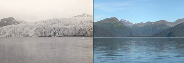
Image credits: McCarty Glacier, Alaska. Left: July 30, 1909. Right: August 11, 2004.1909 picture taken by Ulysses Sherman Grant. 2004 picture taken by Bruce F. Molnia. Glacier Photograph Collection, National Snow and Ice Data Center/World Data Center for Glaciology.
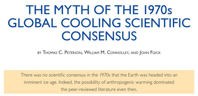
The Myth of the 1970s Global Cooling Scientific Consensus. Click here for the 13 page PDF from The American Meteorological Society.
Climate Change Could Turn Military Bases Into Foreign Policy Problems. Here’s a clip from a story at Futurity: “A new study digs into the impact climate change may have on US military bases around the world, using an abandoned Army base located under the ice in Greenland. Greenland’s vast ice sheet has long been home to the base, originally used for Project Iceworm, a US Army initiative designed to deploy ballistic missiles with nuclear warheads against the Soviet Union. When the project was shuttered in 1967, military planners expected that any materials left on site would be safely frozen in ice and snow in perpetuity. Now, melting ice in a changing Arctic has remobilized some toxic waste at one Project Iceworm site and threatens to do the same at others…”
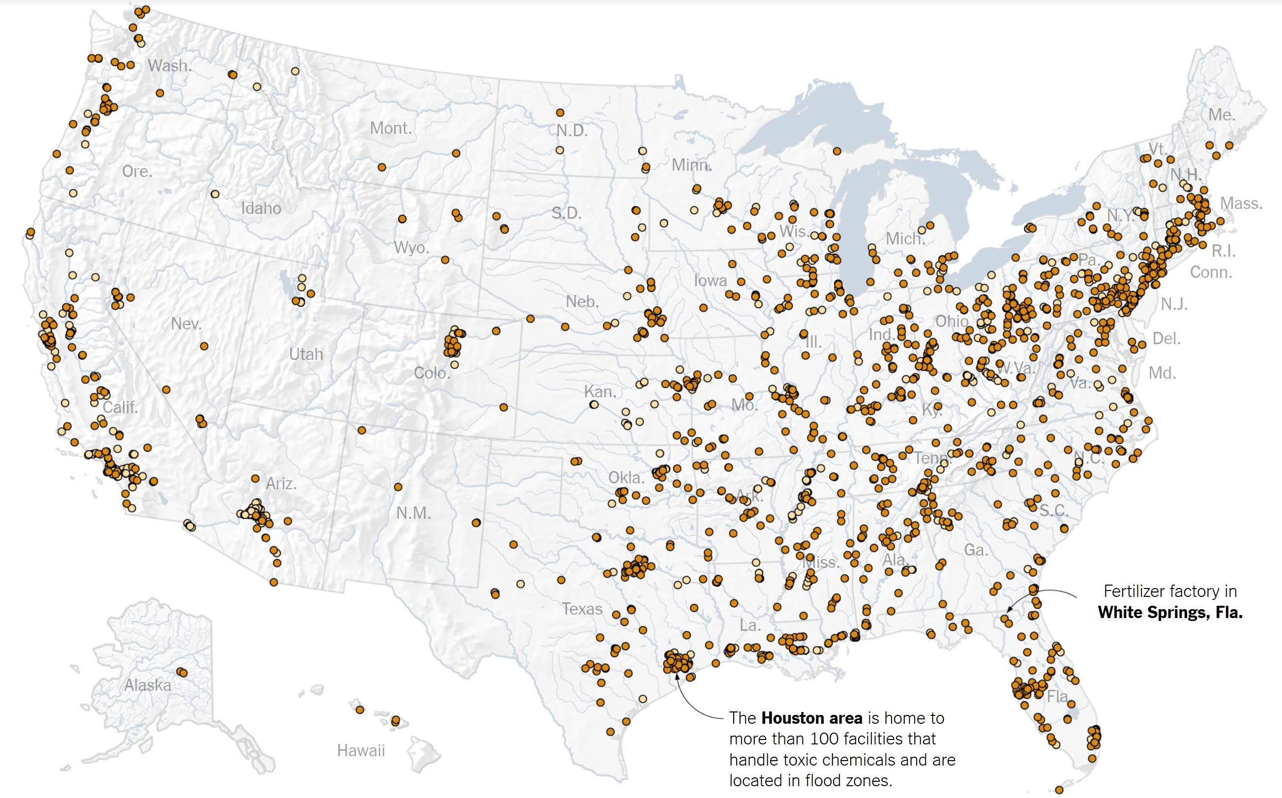
Floods Are Getting Worse, and 2,500 Chemical Sites Lie in the Water’s Path. Here’s the intro to a story at The New York Times: “Anchored in flood-prone areas in every American state are more than 2,500 sites that handle toxic chemicals, a New York Times analysis of federal floodplain and industrial data shows. About 1,400 are located in areas at highest risk of flooding. As flood danger grows – the consequence of a warming climate – the risk is that there will be more toxic spills like the one that struck Baytown, Tex., where Hurricane Harvey swamped a chemicals plant, releasing lye. Or like the ones at a Florida fertilizer plant that leaked phosphoric acid and an Ohio refinery that released benzene…”

Permafrost Could Unlock Enormous Levels of Mercury: From Climate Nexus: “Enormous levels of mercury could be released into the atmosphere if Arctic permafrost thaws, new research shows. A study published Monday in the journal Geophysical Research Letters analyzes mercury cores drilled from permafrost in northern Alaska and finds that the permafrost holds twice the amount of mercury as is stored in all other soils, the atmosphere and the world’s oceans combined. “As permafrost thaws in the future, some portion of this mercury will get released into the environment, with unknown impact to people and our food supplies,” study co-author Kevin Schaefer told the Washington Post.” (Washington Post $, UPI, Alaska Native News)
File image: USGS.

A Trip to a Museum for Convincing Americans About Climate Change. Here’s a clip from a story at The Atlantic: “…The exhibition is the inaugural show of the country’s first climate museum. Housed at the Parsons School of Design, the museum—for now—only consists of the gallery on the corner of 13th Street and Fifth Avenue. After garnering a lot of attention when its founding director Miranda Massie announced the museum’s incorporation in 2015, its first public offering has opened with little fanfare. This is in part because Massie is testing the potential audience for the museum, but also because she’s experimenting with the delicate balance of its content. When she was introduced to Weil through a friend and saw images of 88 Cores, she thought it would not only complement the airy confines of the Parsons gallery, but would also, more importantly, affect people emotionally…”
Photo credit: “‘Whale Bay, Antarctica No.4,’ soft pastel on paper.” Zaria Forman.

Polar Vortex: How the Jet Stream and Climate Change Bring on Cold Snaps. Because what happens in the arctic doesn’t stay in the arctic. A story at InsideClimate News explains how a rapidly warming arctic may be altering the jet stream: “…Rutgers University climate scientist Jennifer Francis has found “robust relationships” between Arctic warming and a wavier jet stream. Melting sea ice speeds up the warming of the Arctic because open water absorbs more heat. And that, in turn, leads to even more sea ice melting. In that vicious cycle, Arctic temperatures are rising twice as fast as the global average. And that’s reducing the temperature contrast that’s one of the jet stream’s main engines, Francis said. More extreme and persistent swings in the jet stream may also be shaping a North American winter weather pattern that’s been common the past few years—a warm and dry West, especially California, and cold waves in the Eastern U.S…”
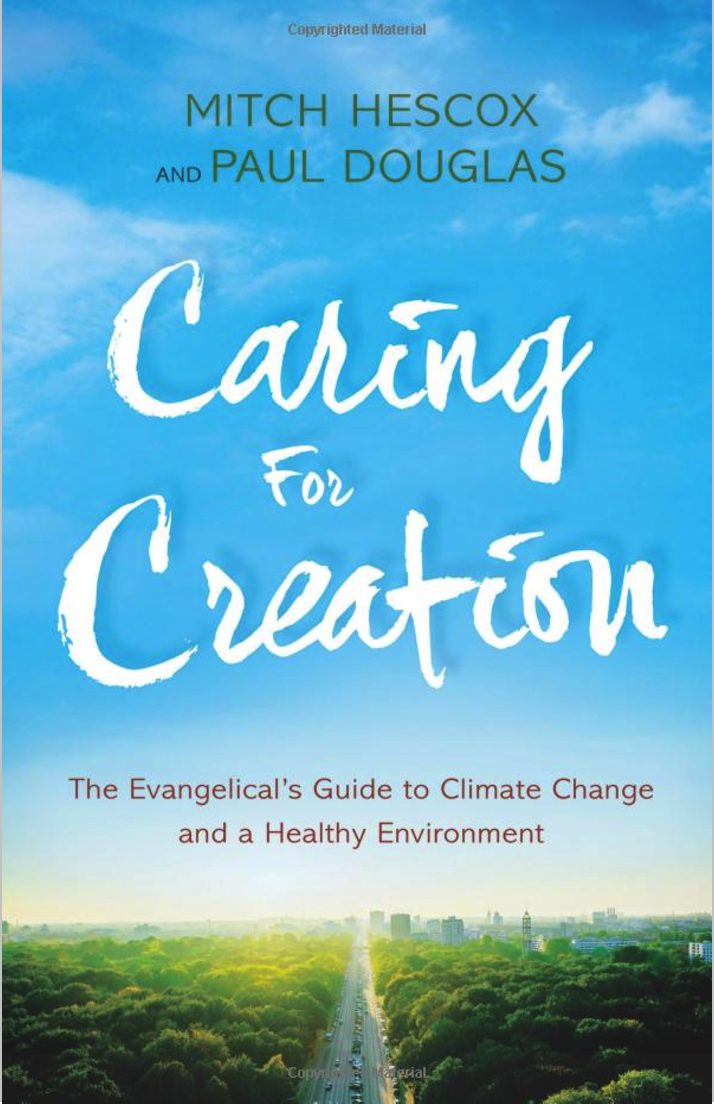
Read Paul’s New Book
Caring for Creation: The Evangelical’s Guide to Climate Change and a Healthy Environment