Paul Douglas
  • Biography
  • Speeches
    • Testimonials
  • Entrepreneurial Approach
    • Paul’s Companies
  • Legal Storm
  • News
    • Scientific Sources
  • Contact
Select Page

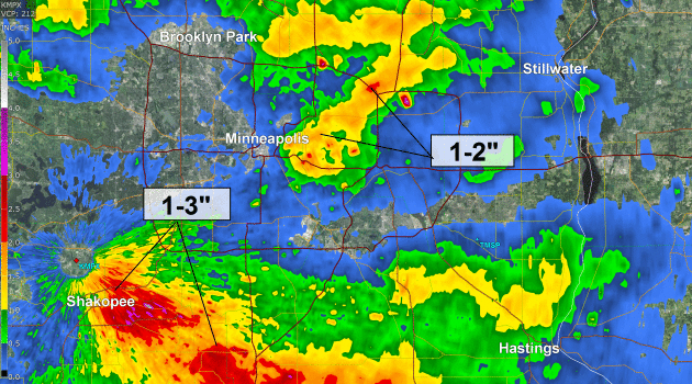
Like 3 Junes in a Row: Another 1-3″ Rain by Saturday Night – Touch of Early October Coming?

by Paul Douglas | Aug 19, 2016 | Blog

85 F. high in the Twin Cities Thursday. 80 F. average high on August 18. 67 F. high on August 18, 2015. August 19, 2007: Record 24-hour maximum rainfall of 15.10 inches set in Hokah, MN (Houston county). This 24-hour total contributed to the record monthly maximum...
Maps Look Like June: Severe Threat Today – Heavy Rain Potential Friday into Saturday – Touch of Autumn This Weekend

Maps Look Like June: Severe Threat Today – Heavy Rain Potential Friday into Saturday – Touch of Autumn This Weekend

by Paul Douglas | Aug 18, 2016 | Blog

86 F. high temperature at MSP International Airport Wednesday. 81 F. average high on August 17. 74 F. high on August 17, 2015. August 18, 1953: Four heifers near St. Martin were lucky; a tornado picked them up and set them back down again, unharmed. Winter is Coming...
Monsoon Season Lingers – Fingerprints of Climate Change in Louisiana’s 1000-year Duluge

Monsoon Season Lingers – Fingerprints of Climate Change in Louisiana’s 1000-year Duluge

by Paul Douglas | Aug 17, 2016 | Blog

86 F. high in the Twin Cities Tuesday. 81 F. average high on August 16. 82 F. high temperature on August 16, 2015. .14″ rain fell at KMSP as of 7pm yesterday. August 17, 1946: A tornado kills 11 people in the Mankato area around 6:52PM. A 27-ton road grader is...

Touch of Dog Days – Autumn Preview Next Weekend – Beware Bolts from the Blue

Touch of Dog Days – Autumn Preview Next Weekend – Beware Bolts from the Blue

by Paul Douglas | Aug 15, 2016 | Blog

83 F. high in the Twin Cities Sunday. 81 F. average high on August 14. 94 F. high on August 14, 2015. August 15, 1936: St. Paul swelters with a high of 108. Beware of Bewildering Bolts from the Blue For 40 years I’ve been preaching the perils of lightning, and...
Not as Hot or Wet as Last Week – Historic, 500-Year Flood Grips Louisiana

Not as Hot or Wet as Last Week – Historic, 500-Year Flood Grips Louisiana

by Paul Douglas | Aug 14, 2016 | Blog

81 F. high temperature yesterday at KMSP 81 F. average high on August 13. 85 F. high in the Twin Cities on August 13, 2015. 4.1″ rain so far in August. 1.9″ average rainfall as of August 13. .79″ rainfall during the first 13 days of August, 2015....
« Older Entries
Next Entries »

Caring For Creation Book

Recent Posts

  • Tracking Superior Refinery Fire Plume – Spotty Shower Today – Fine Weekend Brewing April 27, 2018
  • Spotty Instability Showers Next 36 Hours – Weekend Warming Trend April 26, 2018
  • An Extended Spring Fling – Wetter/Stormier Pattern Next Week? April 25, 2018

Archives

  • April 2018
  • March 2018
  • February 2018
  • January 2018
  • December 2017
  • November 2017
  • October 2017
  • September 2017
  • August 2017
  • July 2017
  • June 2017
  • May 2017
  • April 2017
  • March 2017
  • February 2017
  • January 2017
  • December 2016
  • November 2016
  • October 2016
  • September 2016
  • August 2016
  • July 2016
  • June 2016
  • May 2016
  • April 2016
  • March 2016
  • February 2016
  • January 2016
  • December 2015
  • November 2015
  • October 2015
  • September 2015
  • August 2015
  • July 2015
  • June 2015
  • May 2015
  • April 2015
  • March 2015
  • February 2015
  • January 2015
  • December 2014
  • November 2014
  • October 2014
  • September 2014
  • August 2014
  • July 2014
  • June 2014
  • May 2014
  • April 2014
  • March 2014

Latest Post

  • Tracking Superior Refinery Fire Plume – Spotty Shower Today – Fine Weekend Brewing
  • Facebook
  • Twitter
  • RSS
Website designed by Walt Kruhoeffer