Paul Douglas
  • Biography
  • Speeches
    • Testimonials
  • Entrepreneurial Approach
    • Paul’s Companies
  • Legal Storm
  • News
    • Scientific Sources
  • Contact
Select Page
Strong to Severe T-storms Into Wednesday – Extended Heat Spell in Late June?

Strong to Severe T-storms Into Wednesday – Extended Heat Spell in Late June?

by Paul Douglas | Jun 13, 2017 | Blog

.20″ rain fell yesterday at Twin Cities International Airport. 83 F. maximum temperature in the Twin Cities Monday. 78 F. average high on June 12. 78 F. high on June 12, 2016. June 13, 1991: One fatality and 5 injuries occur when lightning strikes a tree at...
Details on Sunday’s Rare Derecho – How Long Will Sticky Weather Hang On?

Details on Sunday’s Rare Derecho – How Long Will Sticky Weather Hang On?

by Paul Douglas | Jun 12, 2017 | Blog

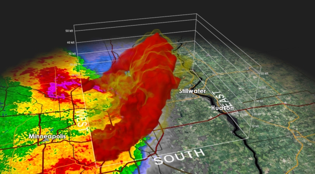
1.82″ rain fell yesterday in the Twin Cities. 69 mph peak wind gust from yesterday’s severe storms (MSP International Airport). 79 F. maximum temperature in the Twin Cities yesterday, shortly after midnight. 78 F. average high on June 11. 93 F. high on...
Severe Storms and Flash Flooding Today – Breathing Easier by Late Week

Severe Storms and Flash Flooding Today – Breathing Easier by Late Week

by Paul Douglas | Jun 11, 2017 | Blog

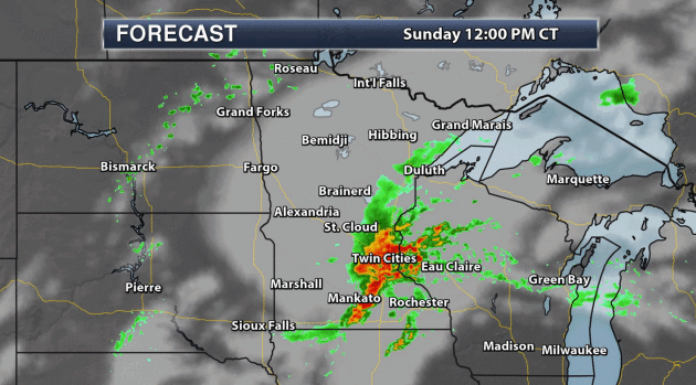
96 F. maximum temperature in the Twin Cities Saturday. 77 F. average high on June 10. 91 F. high on June 10, 2016. June 11, 2011: Severe thunderstorms bring extremely strong wind to central Minnesota. An unofficial wind gust of 119 mph is reported at a seed farm 1...
Heat Advisory – Fun Mix of Arizona and Florida Today;  Strong T-storms Sunday

Heat Advisory – Fun Mix of Arizona and Florida Today; Strong T-storms Sunday

by Paul Douglas | Jun 10, 2017 | Blog

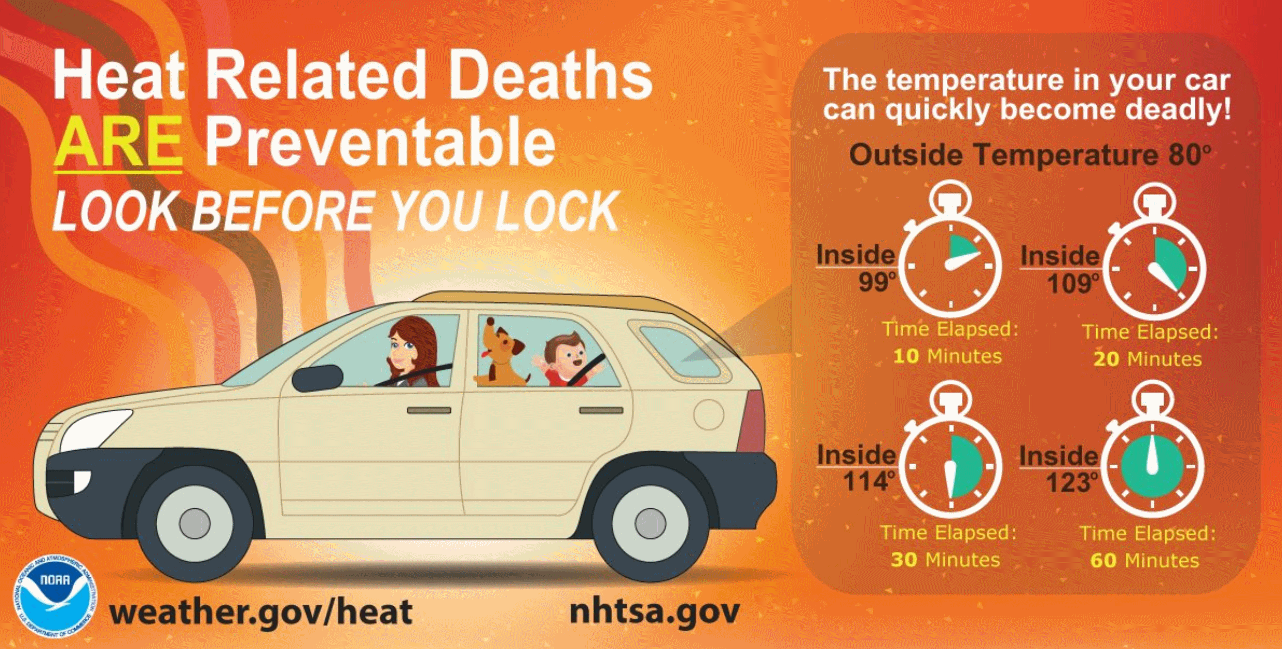
86 F. Twin Cities maximum temperature yesterday. 77 F. average high on June 9. 84 F. high on June 9, 2016. June 10, 1926: An intense downpour falls on Mahoning. 3.05 inches fell in 45 minutes.   If Anyone Asks: “Yes, It’s Hot Enough For Me” At...
Heat Spike Brewing – Steamy Next 6 Days. Military Preparing for Climate Change

Heat Spike Brewing – Steamy Next 6 Days. Military Preparing for Climate Change

by Paul Douglas | Jun 9, 2017 | Blog

85 F. high temperature in the Twin Cities Thursday. 77 F. average high on June 8. 79 F. maximum temperature on June 8, 2016. June 9, 2002: Extensive flash flood begins across northwest Minnesota. 14.55 inches would fall over the next 48 hours near Lake of the Woods....
« Older Entries
Next Entries »

Caring For Creation Book

Recent Posts

  • Tracking Superior Refinery Fire Plume – Spotty Shower Today – Fine Weekend Brewing April 27, 2018
  • Spotty Instability Showers Next 36 Hours – Weekend Warming Trend April 26, 2018
  • An Extended Spring Fling – Wetter/Stormier Pattern Next Week? April 25, 2018

Archives

  • April 2018
  • March 2018
  • February 2018
  • January 2018
  • December 2017
  • November 2017
  • October 2017
  • September 2017
  • August 2017
  • July 2017
  • June 2017
  • May 2017
  • April 2017
  • March 2017
  • February 2017
  • January 2017
  • December 2016
  • November 2016
  • October 2016
  • September 2016
  • August 2016
  • July 2016
  • June 2016
  • May 2016
  • April 2016
  • March 2016
  • February 2016
  • January 2016
  • December 2015
  • November 2015
  • October 2015
  • September 2015
  • August 2015
  • July 2015
  • June 2015
  • May 2015
  • April 2015
  • March 2015
  • February 2015
  • January 2015
  • December 2014
  • November 2014
  • October 2014
  • September 2014
  • August 2014
  • July 2014
  • June 2014
  • May 2014
  • April 2014
  • March 2014

Latest Post

  • Tracking Superior Refinery Fire Plume – Spotty Shower Today – Fine Weekend Brewing
  • Facebook
  • Twitter
  • RSS
Website designed by Walt Kruhoeffer