Paul Douglas
  • Biography
  • Speeches
    • Testimonials
  • Entrepreneurial Approach
    • Paul’s Companies
  • Legal Storm
  • News
    • Scientific Sources
  • Contact
Select Page
Enjoy the Free A/C – Holiday Thunderstorms – A Real Heat Wave in July?

Enjoy the Free A/C – Holiday Thunderstorms – A Real Heat Wave in July?

by Paul Douglas | Jun 26, 2017 | Blog

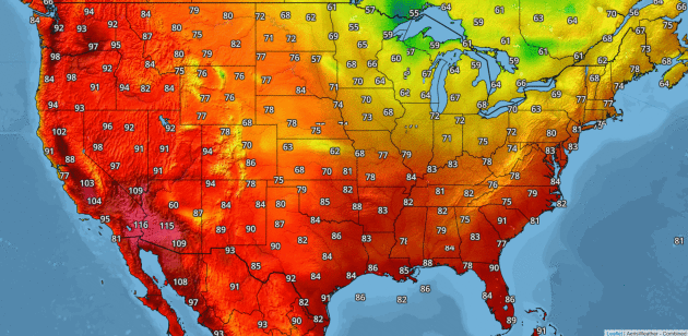
69 F. Twin Cities maximum temperature on Sunday. 82 F. average high on June 25. 96 F. high on June 25, 2016. June 26, 1982: Cold air moves into northern Minnesota. Kulger Township dips to 31 degrees. Duluth registers 36. Enjoy the Free A/C – July Heat Wave...
Canadian Breeze – Low Weather Expectations for 4th of July Weekend

Canadian Breeze – Low Weather Expectations for 4th of July Weekend

by Paul Douglas | Jun 25, 2017 | Blog

66 F. maximum temperature yesterday in the Twin Cities. 82 F. average high on June 24. 82 F. high on June 24, 2016. June 25, 2003: Heavy rain falls across central Minnesota. Elk River picks up 8.19 inches. 4.36 inches fall in 4 hours in Maplewood, and there are...
Vague Hints of October This Weekend – Milder for 4th of July – Climate Hot Spots

Vague Hints of October This Weekend – Milder for 4th of July – Climate Hot Spots

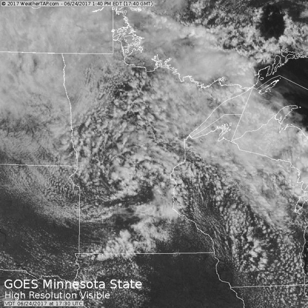
by Paul Douglas | Jun 24, 2017 | Blog

74 F. high temperature in the Twin Cities on Friday. 81 F. average high on June 23. 77 F. high on June 23, 2016. June 24, 2002: Heavy rains fall on already saturated ground, leading to flooding. 5.50 inches fall at Delano, and half of a mobile home park at Howard Lake...
Extended Intermission From Heat & Humidity – Cool Bias Into 4th of July

Extended Intermission From Heat & Humidity – Cool Bias Into 4th of July

by Paul Douglas | Jun 23, 2017 | Blog

.49″ rain fell in the Twin Cities yesterday. 72 F. Thursday high temperature. 81 F. average Twin Cities high on June 22. 83 F. high on June 22, 2016. June 23, 2002: Just a few weeks after torrential rains hit the area, another round of heavy rain hits northern...
Welcome Summer Solstice – Cool Bias – Major Flood Risk Gulf Coast

Welcome Summer Solstice – Cool Bias – Major Flood Risk Gulf Coast

by Paul Douglas | Jun 20, 2017 | Blog

74 F. maximum temperature yesterday in the Twin Cities. 80 F. average high on June 19. 93 F. high on June 19, 2016. June 20, 1992: Abnormally cold conditions occur across the north. Temperatures drop to 26 at Embarrass, MN and Hayward, WI, but the cold spot is 24 at...
« Older Entries
Next Entries »

Caring For Creation Book

Recent Posts

  • Tracking Superior Refinery Fire Plume – Spotty Shower Today – Fine Weekend Brewing April 27, 2018
  • Spotty Instability Showers Next 36 Hours – Weekend Warming Trend April 26, 2018
  • An Extended Spring Fling – Wetter/Stormier Pattern Next Week? April 25, 2018

Archives

  • April 2018
  • March 2018
  • February 2018
  • January 2018
  • December 2017
  • November 2017
  • October 2017
  • September 2017
  • August 2017
  • July 2017
  • June 2017
  • May 2017
  • April 2017
  • March 2017
  • February 2017
  • January 2017
  • December 2016
  • November 2016
  • October 2016
  • September 2016
  • August 2016
  • July 2016
  • June 2016
  • May 2016
  • April 2016
  • March 2016
  • February 2016
  • January 2016
  • December 2015
  • November 2015
  • October 2015
  • September 2015
  • August 2015
  • July 2015
  • June 2015
  • May 2015
  • April 2015
  • March 2015
  • February 2015
  • January 2015
  • December 2014
  • November 2014
  • October 2014
  • September 2014
  • August 2014
  • July 2014
  • June 2014
  • May 2014
  • April 2014
  • March 2014

Latest Post

  • Tracking Superior Refinery Fire Plume – Spotty Shower Today – Fine Weekend Brewing
  • Facebook
  • Twitter
  • RSS
Website designed by Walt Kruhoeffer