Paul Douglas
  • Biography
  • Speeches
    • Testimonials
  • Entrepreneurial Approach
    • Paul’s Companies
  • Legal Storm
  • News
    • Scientific Sources
  • Contact
Select Page
Nearly 8″ Rain in August – NASA Says Earth Warming at “Unprecedented” Rate

Nearly 8″ Rain in August – NASA Says Earth Warming at “Unprecedented” Rate

by Paul Douglas | Aug 31, 2016 | Blog

81 F. high temperature at KMSP Tuesday. 78 F. average high on August 30. 81 F. high on August 30, 2015. 7.82″ rain in the Twin Cities in August. 4.93″ wetter than average since June 1. Comfortably Cool and Dry Weather Into Saturday The proliferation of...
Flash Flooding Overnight – Cooling Trend – Tropical Storm Landfall North of Tampa by Thursday?

Flash Flooding Overnight – Cooling Trend – Tropical Storm Landfall North of Tampa by Thursday?

by Paul Douglas | Aug 30, 2016 | Blog

86 F. high in the Twin Cities Monday. 78 F. average high on August 29. 74 F. high on August 29, 2015. August 30, 1977: Flooding occurs on the southwest side of the Twin Cities, with MSP Airport getting 7.28 inches of rain in 4 1/2 hours. Slight Cooling – Tropics...
Hanging Onto Summer – Growing Potential for Trouble in the Tropics

Hanging Onto Summer – Growing Potential for Trouble in the Tropics

by Paul Douglas | Aug 29, 2016 | Blog

85 F. maximum temperature in the Twin Cities Sunday. 78 F. average high on August 28. 76 F. high on August 28, 2015. August 29, 1948: An airliner crashes during a thunderstorm near Winona, killing 37 people on board. August 29, 1863: A devastating killing frost...
Summer Warmth Hangs On Into Labor Day – Potential for Gulf of Mexico Hurricane Increases

Summer Warmth Hangs On Into Labor Day – Potential for Gulf of Mexico Hurricane Increases

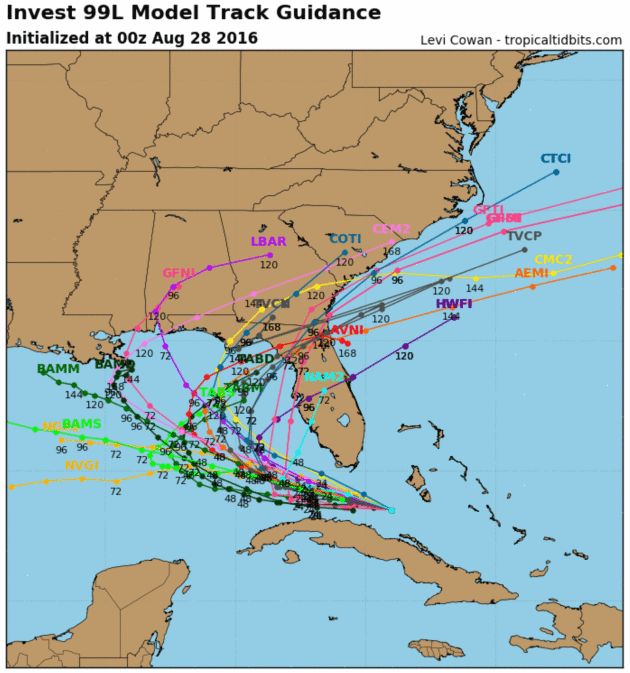
by Paul Douglas | Aug 28, 2016 | Blog

68 F. high temperature in the Twin Cities Saturday. 79 F. average high on August 27. 76 F. high on August 27, 2015. August 28, 1989: Baseball-sized hail pummels Pequot Lakes. Warming Trend – Growing Threat of “Hermine” “Hurricane season brings...
Thundery Warm Front  – Lingering Tropical Storm Uncertainty and Risk

Thundery Warm Front – Lingering Tropical Storm Uncertainty and Risk

by Paul Douglas | Aug 27, 2016 | Blog

72 F. high in the Twin Cities Friday. 79 F. average high on August 26. 75 F. high on August 26, 2015. August 27, 1992: A chilly night in Embarrass, where the temperature dips to 28 degrees. Weather Maps Looks Summery Into Early September Welcome armchair...
« Older Entries

Caring For Creation Book

Recent Posts

  • Tracking Superior Refinery Fire Plume – Spotty Shower Today – Fine Weekend Brewing April 27, 2018
  • Spotty Instability Showers Next 36 Hours – Weekend Warming Trend April 26, 2018
  • An Extended Spring Fling – Wetter/Stormier Pattern Next Week? April 25, 2018

Archives

  • April 2018
  • March 2018
  • February 2018
  • January 2018
  • December 2017
  • November 2017
  • October 2017
  • September 2017
  • August 2017
  • July 2017
  • June 2017
  • May 2017
  • April 2017
  • March 2017
  • February 2017
  • January 2017
  • December 2016
  • November 2016
  • October 2016
  • September 2016
  • August 2016
  • July 2016
  • June 2016
  • May 2016
  • April 2016
  • March 2016
  • February 2016
  • January 2016
  • December 2015
  • November 2015
  • October 2015
  • September 2015
  • August 2015
  • July 2015
  • June 2015
  • May 2015
  • April 2015
  • March 2015
  • February 2015
  • January 2015
  • December 2014
  • November 2014
  • October 2014
  • September 2014
  • August 2014
  • July 2014
  • June 2014
  • May 2014
  • April 2014
  • March 2014

Latest Post

  • Tracking Superior Refinery Fire Plume – Spotty Shower Today – Fine Weekend Brewing
  • Facebook
  • Twitter
  • RSS
Website designed by Walt Kruhoeffer