Paul Douglas
  • Biography
  • Speeches
    • Testimonials
  • Entrepreneurial Approach
    • Paul’s Companies
  • Legal Storm
  • News
    • Scientific Sources
  • Contact
Select Page
Spring Officially Returns – Highs In The 70s To End The Week – Tornado Sirens To Sound Thursday

Spring Officially Returns – Highs In The 70s To End The Week – Tornado Sirens To Sound Thursday

by Paul Douglas | Apr 14, 2016 | Blog

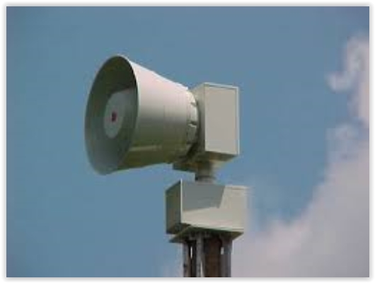
Tornado Drill Day Is Thursday! Unlike the technical malfunction that allowed the tornado sirens to sound Tuesday morning in Hennepin County, when you hear the sirens go off late today (Thursday) they are actually supposed to! As part of Severe Weather Awareness Week...
Flurries Yesterday – 70s Thursday.  Welcome to Spring in Minnesota

Flurries Yesterday – 70s Thursday. Welcome to Spring in Minnesota

by Paul Douglas | Apr 13, 2016 | Blog

49 F. high in the Twin Cities Tuesday. 56 F. average high on April 12. 75 F. high on April 12, 2015. Trace of rain yesterday at KMSP. Trace of snow reported. April 13, 1949: A late-season snowstorm dumps over 9 inches in parts of the Twin Cities metro area. Tell Me a...
Increasingly Springy This Week – This is Severe Weather Awareness Week in Minnesota

Increasingly Springy This Week – This is Severe Weather Awareness Week in Minnesota

by Paul Douglas | Apr 11, 2016 | Blog

59 F. high in the Twin Cities Sunday. 55 F. average high on April 10. 56 F. high temperature on April 10, 2015. April 11, 1929: An intense downpour occurs in Lynd, Minnesota (near Marshall), where 5.27 inches of rain would fall in 24 hours. This is Severe Weather...
50s Return Sunday Before A Quick Cool Down To Begin The Work Week

50s Return Sunday Before A Quick Cool Down To Begin The Work Week

by Paul Douglas | Apr 10, 2016 | Blog

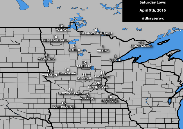
Record Cold Start In Parts Of The State Saturday Many of you probably reached for your jacket Saturday morning as you were heading out the door to some pretty chilly conditions for this time of year. The low got down to 20 in the Twin Cities, which was five degrees...
Calmer Saturday With A Mix Of Clouds And Sun – Highs In The 60s By Late Next Week

Calmer Saturday With A Mix Of Clouds And Sun – Highs In The 60s By Late Next Week

by Paul Douglas | Apr 9, 2016 | Blog

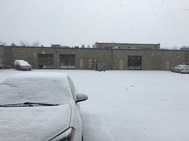
Snowy Friday Across The Twin Cities A heavy burst of snow moved through the metro Friday morning, sliding south and east during the commute and causing a number of accidents, particularly in the northwest metro. This was just one of many bottlenecks that occurred due...
« Older Entries
Next Entries »

Caring For Creation Book

Recent Posts

  • Tracking Superior Refinery Fire Plume – Spotty Shower Today – Fine Weekend Brewing April 27, 2018
  • Spotty Instability Showers Next 36 Hours – Weekend Warming Trend April 26, 2018
  • An Extended Spring Fling – Wetter/Stormier Pattern Next Week? April 25, 2018

Archives

  • April 2018
  • March 2018
  • February 2018
  • January 2018
  • December 2017
  • November 2017
  • October 2017
  • September 2017
  • August 2017
  • July 2017
  • June 2017
  • May 2017
  • April 2017
  • March 2017
  • February 2017
  • January 2017
  • December 2016
  • November 2016
  • October 2016
  • September 2016
  • August 2016
  • July 2016
  • June 2016
  • May 2016
  • April 2016
  • March 2016
  • February 2016
  • January 2016
  • December 2015
  • November 2015
  • October 2015
  • September 2015
  • August 2015
  • July 2015
  • June 2015
  • May 2015
  • April 2015
  • March 2015
  • February 2015
  • January 2015
  • December 2014
  • November 2014
  • October 2014
  • September 2014
  • August 2014
  • July 2014
  • June 2014
  • May 2014
  • April 2014
  • March 2014

Latest Post

  • Tracking Superior Refinery Fire Plume – Spotty Shower Today – Fine Weekend Brewing
  • Facebook
  • Twitter
  • RSS
Website designed by Walt Kruhoeffer