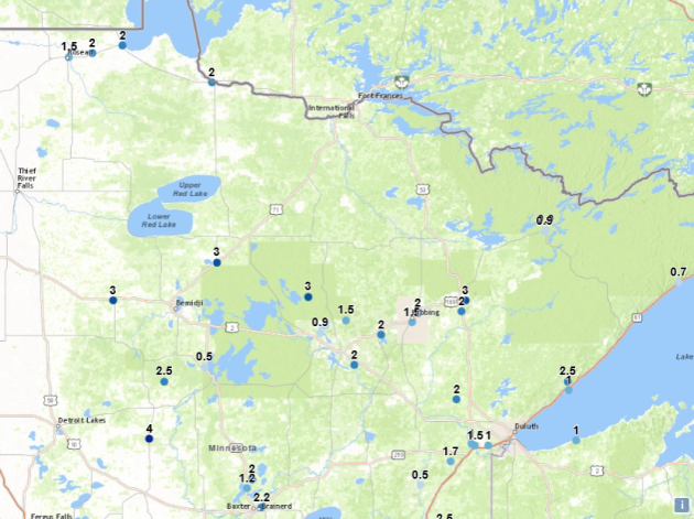
Snowfall Reports Through 5 PM Sunday


_______________________________________________
Wind Chill Advisories And Warnings

We’re in for another couple nights of Wind Chill Advisories and Warnings across most of the state of Minnesota. Timing is different on some of these alerts: some are tonight through midday Monday, some are tonight through Tuesday morning, others (including the advisory including the Twin Cities) are from midday Monday to Tuesday morning. Here’s the warning text for the advisory that includes the Twin Cities:


The coldest wind chills as you wake up Monday morning will be across northwestern Minnesota, where they could dip below -40. Across southern Minnesota, wind chills will be between -20 and -40 throughout the night.

Much of the same is expected as you wake up Tuesday morning, with wind chills even dipping to around -40 as far south as Alexandria.
_______________________________________________
Welcome to One of the Coldest Days of Winter
By Paul Douglas
Man is it cold out there. “How cold is it, Paul?” It’s so cold lawyers have their hands in their own pockets. It’s so cold I welcomed my hot flashes. It’s so cold cows are now dispensing ice cream.
Welcome to one of the 3 coldest days of winter; daytime highs hovering below zero even in the Twin Cities metro, in spite of an urban heat island. Morning wind chills dip to -25F at MSP, as cold as -45 in western counties. A good day to hunker down and hibernate.
Nanook air won’t linger long: 20s return by Wednesday with a shot at 40F by Friday. Saturday should be a good travel day, but models suggest a close encounter with wet snow Sunday, especially far eastern Minnesota and Wisconsin.
I see a persistent low pressure trough forming out west, a storm-incubator, which could mean frequent
storms later in January. By then the question may be: all snow or a mix of rain, ice and snow?
Figures. Either it’s hella-cold or meteorologists are babbling about a “sloppy mix”. Now is the winter of our discontent. By tomorrow the coldest days may be behind us. Just a gut call. Could be nausea.
_______________________________________________
Extended Twin Cities Forecast
MONDAY: Nanook. Feels like -25F. High 0. Low -9. Chance of precipitation 20%. Wind NW 10-20 mph.
TUESDAY: Partly sunny, numb and number. High 7. Low -2. Chance of precipitation 10%. Wind NW 7-12 mph.
WEDNESDAY: Intervals of sun, nice to be average. High 23. Low 16. Chance of precipitation 10%. Wind SW 7-12 mph.
THURSDAY: Patchy clouds, welcome thaw. High 34. Low 24. Chance of precipitation 10%. Wind W 5-10 mph.
FRIDAY: Overcast, feels like February. High 38. Low 27. Chance of precipitation 10%. Wind S 10-15 mph.
SATURDAY: Gray, better travel day of weekend. High 36. Low 25. Chance of precipitation 20%. Wind W 5-10 mph.
SUNDAY: Chance of wet snow developing. High 30. Low 18. Chance of precipitation 70%. Wind N 8-13 mph.
_______________________________________________
This Day in Weather History
January 15th
1981: Over 24,000 Canada Geese are present at Silver Lake in Rochester.
1952: A sleet and freezing rain storm develops across Minnesota from St Cloud south into Iowa. 1,100 Northwestern Bell telephone wires are knocked down. The Buffalo Ridge in the Pipestone area is the hardest hit with ¾ inches of solid ice on Northern State Power wires with icicles to 3 inches. Northwestern Bell reported ice up to 1 ½ inches on their wires in the same area. Thunder and a shower of ice pellets accompanied the storm in New Ulm and Mankato. Minneapolis General Hospital treated 81 people, victims of falls on icy streets.
_______________________________________________
Average Temperatures & Precipitation for Minneapolis
January 15th
Average High: 23F (Record: 43F set in 1990)
Average Low: 7F (Record: -37F set in 1888)
Average Precipitation: 0.03″ (Record: 0.45″ set in 1969)
Average Snow: 0.4″ (Record: 3.2″ set in 1953)
_______________________________________________
Sunrise/Sunset Times for Minneapolis
January 15th
Sunrise: 7:47 AM
Sunset: 4:57 PM
*Length Of Day: 9 hours, 10 minutes and 21 seconds
*Daylight Gained Since Yesterday: ~1 minutes and 49 seconds
*Next Sunrise at/before 7:30 AM: February 3rd (7:30 AM)
*Next Sunset at/after 5 PM: January 17th (5:00 PM)
_______________________________________________
Minnesota Weather Outlook

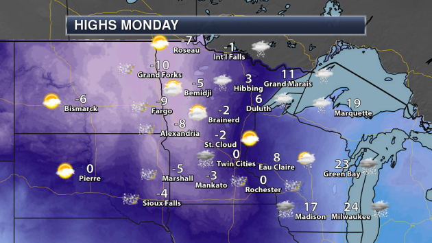
A cold M.L.K. Day is expected Monday, with highs barely making it to 0 in the Twin Cities. Highs will be coldest across the western half of Minnesota, where they will remain below zero. Highs will actually be the warmest in the Arrowhead, where Grand Marais is expected to reach 11. Blowing snow will be an issue as winds will be gusty, and a little bit more snow will be possible across parts of the state.

What a way to start off (another) week across the state, with highs that will be 10 to 30 degrees below average for this time of year.

It will continue to feel much colder than those highs throughout Monday, however, as wind gusts will be in the 20 mph range across much of the state.

We’ll start to rebound temperature-wise on Tuesday, with only parts of west-central and northwestern Minnesota seeing highs slightly below zero. Most of the rest of the state will see highs in the single digits above zero.

Warmer air really starts to move in Wednesday, with highs in the teens and 20s across the state under a mix of clouds and sun.
But then we see the return of 30s as we head into the end of the week and beginning of the weekend here in the Twin Cities – a much needed warm up, I will say. Unfortunately another blast of cold air looks to move in Sunday into the beginning of the next week behind a storm system moving through the central portion of the country.

We will have to watch that system for next weekend closely, as some models are indicating the potential of accumulating snow across the region. Again, just like the past few storms, we won’t know for certain until a couple of days ahead of the storm where exactly the path could be, which will determine the amount of snow received. As I have said before: keep an eye on it, but no need to panic just yet. Let’s get toward the middle and end of the week, then we’ll have a better idea of what could happen.
_______________________________________________
National Weather Forecast

A cold front will continue to sag south and east Monday, with the potential of snow throughout the day from the Great Lakes to the mid-Mississippi Valley. A wintry mix – even ice – will be possible across parts of Arkansas into Texas, especially into Monday night. Strong high pressure will be working in behind that cold front, with another blast of cold, Canadian air. Elsewhere, a cold front will be approaching the west coast, bringing the potential of rain (and higher elevation snow) from the Pacific Northwest south to the Bay Area.

You can see that cold air expanding south and east on the departure from average highs map for Monday, with the coldest air centered over the Northern Plains (a good 20-30 degrees below average for this time of year). The eastern United States will remain below average as well Monday, with warmer than average weather found mainly east of the Rockies.

Precipitation totals through Friday morning will be heaviest across parts of the Northwest into northern California, where 3-6″ of liquid will be possible. Elsewhere, precipitation values will generally be under an inch this week.
_______________________________________________
Self-Driving Cars In Bad Weather
Driving in snowy weather is tough (look at all the accidents that happen every time it snows here in the Twin Cities). That’s no different for self-driving cars. More from Marketplace Tech: “It’s hard for humans to drive in bad weather, and it’s hard for self-driving cars to drive in it, too. Many of the cars started their lives in sunny California and haven’t experienced much of the world. So automakers are sending them out into more snowy climes. Marketplace Tech host Molly Wood talks about it with Chris Gerdes, director of the Center for Automotive Research at Stanford.”
Low Reservoirs In New Jersey
Before the rain to end last week, the Northeast was dealing with a very dry winter so far. It was so dry that water reservoirs were watching serious drops. More from the Daily Record: “The biting, two-week cold snap we just survived overshadowed another weather phenomenon quietly playing out that could have dire consequences in the spring: We’ve had a dearth of rain or snow over the past 60 to 90 days. As a result, North Jersey’s drinking water reservoirs are quite low for this time of year. Normally, they are replenishing now, so they are full when warm weather triggers peak water demand.” (Image: The Passaic River is running at 6 percent of normal flow. The shore of the river in Woodland Park along McBride Avenue is clearly visible on Wednesday, Jan. 10.(Photo: Amy Newman/NorthJersey.com))
Drought Affecting Ski Area In New Mexico

The Enhanced Forest ski area in New Mexico is having issues due to very little snow so far this winter. More from the Albuquerque Journal: “The Enchanted Forest cross-country ski and snowshoe area in northern New Mexico remains closed due to a lack of snow and the operator is seeking financial donations to help stay afloat until next year. Ellen Miller-Goins “This is unprecedented; there’s just no snow and we weren’t prepared for this,” says Ellen Miller-Goins of Red River, owner of the outdoor resort.” (Image: A photo from a past winter shows the Enchanted Forest cross-country ski and snowshoeing area as it is normally seen – with snow – at this time of year. (Courtesy of Enchanted Forest))
Warm Weather Helped Ice Fishing In Iowa Last Week
After recent cold weather, Iowans were out ice fishing early last week when it finally warmed up. More from the Sioux City Journal: “Zach Mankle lit a cigarette while sitting on a 5-gallon bucket at the apex of a Monday afternoon in Okoboji. “This is my first time out here this season,” Mankle said. “It’s been way too cold before. Today feels like fall.” As temperatures in the Iowa Great Lakes inched past 40 degrees, hundreds of anglers joined Mankle on the ice, thickened to a foot or so, according to most, thanks to a couple of weeks of single-digit and below-zero readings.”
________________________________________________
Thanks for checking in and have a great Monday! Don’t forget to follow me on Twitter (@dkayserwx) and like me on Facebook (Meteorologist D.J. Kayser)!
– D.J. Kayser


