Snow Continues Saturday Night
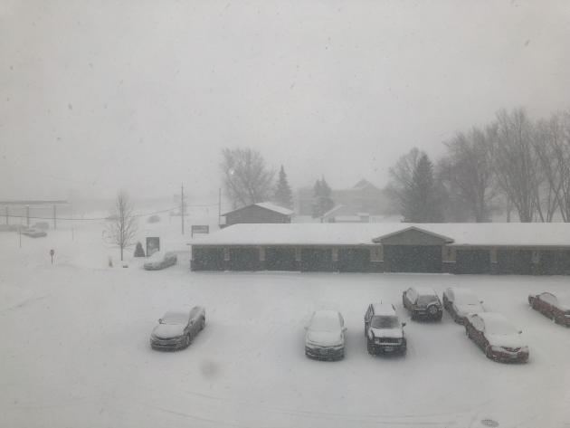
Snow was already falling across the Twin Cities during the late afternoon hours Saturday, quite heavily at times. And I noticed the title games for high school girls hockey were Saturday… so we can officially call this a tournament snow storm, right? This is what the falling snow looked like Saturday afternoon in the St. Cloud area.
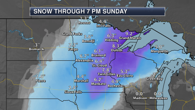
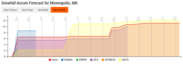
Overall, here are the snow totals we are expecting from this system. We could see a swath of 6-10”+ from southern Minnesota to the Arrowhead by the time the snow moves out Saturday Night into early Sunday.
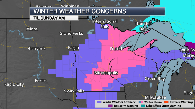
(Advisory map as of 4:30 PM Saturday) Due to the snow, Winter Storm Warnings and Winter Weather Advisories remains in effect into early Sunday. Winds will also pick up behind the snow, causing some blowing and potentially drifting issues.
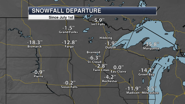
This snow is good news for at least one category: the season departure from average. Through Friday, we were 2.8” below average in the Twin Cities since the snow season began. This system should push us into the positive range.
_______________________________________________
We Go From The Big Dig to The Big Melt This Week
By Paul Douglas
The 7-Day Outlook calls for slush, mush, Blue Juice (windshield washer solution) and second-string shoes. A word to the wise: if you like snow, take full advantage of today. It won’t get any better than this.
I like snow. For a fleeting, frozen moment in time the landscape is white-washed, sun-scrubbed and pristine; worthy of a postcard. It’s nature’s do-over. In the twinkle of an eye, we are children again.
A mid-October sun angle will help to melt all that new snow in your yard in the coming days. Models show highs near 40F by midweek, so the Big Melt is inevitable. Borrow a friend’s shoes, because it’s going to be a slop-fest out there the next couple of weeks.
After nearly an inch of liquid water from two snowstorms two days apart there’s no more weather-drama – the maps look quiet into mid-March. Future storms will probably be a mix of rain and snow; the days of all-snow are winding down.
So here we are, enjoying an average winter – snowfall and temperatures very close to normal. Last winter was mild with little snow, so an average winter almost feels like punishment!
_______________________________________________
Extended Twin Cities Forecast
SUNDAY: Partly sunny, breezy. High 30. Low 18. Chance of precipitation 10%. Wind NW 10-20 mph.
MONDAY: Clouds increase, trending milder. High 37. Low 27. Chance of precipitation 10%. Wind SW 5-10 mph.
TUESDAY: Patchy fog and clouds. High 40. Low 28. Chance of precipitation 10%. Wind SE 3-8 mph.
WEDNESDAY: Clouds linger, sloppy out there. High 39. Low 24. Chance of precipitation 10%. Wind SE 3-8 mph.
THURSDAY: Peeks of sun, still quiet. High 37. Low 21. Chance of precipitation 10%. Wind NW 7-12 mph.
FRIDAY: Bright sun, light winds. High 39. Low 25. Chance of precipitation 0%. Wind NW 3-8 mph.
SATURDAY: Clouds and winds increase. High 43. Low 31. Chance of precipitation 20%. Wind SE 10-20 mph.
_______________________________________________
This Day in Weather History
February 25th
1934: A late season cold snap produces a bitterly cold low of -46 at Big Falls.
_______________________________________________
Average Temperatures & Precipitation for Minneapolis
February 25th
Average High: 32F (Record: 58F set in 1976)
Average Low: 17F (Record: -23F set in 1967)
Average Precipitation: 0.03″ (Record: 0.63″ set in 1944)
Average Snow: 0.3″ (Record: 4.8″ set in 2001)
_______________________________________________
Sunrise/Sunset Times for Minneapolis
February 25th
Sunrise: 6:57 AM
Sunset: 5:55 PM
*Length Of Day: 10 hours, 57 minutes and 31 seconds
*Daylight Gained Since Yesterday: ~3 minutes and 4 seconds
*Sunrises After 7 AM Begin Again March 11th (7:32 AM) Due To Daylight Saving Time
*Next Sunset at/after 6 PM: March 1st (6:00 PM)
_______________________________________________
Minnesota Weather Outlook
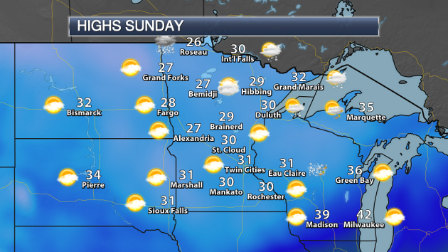
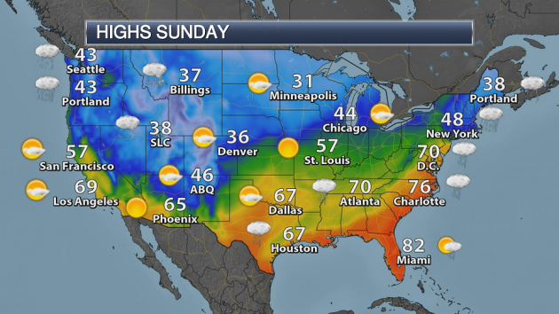
Saturday Night’s snow will have pushed out of the region for the most part by the morning hours Sunday, with only a few lingering snowflakes across northern Minnesota early on in the day. Highs will be in the 20s and 30s across the state with a mix of clouds and sun.
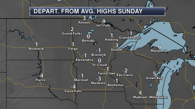
Highs on Sunday will be around average for the most part around the state – enjoy!
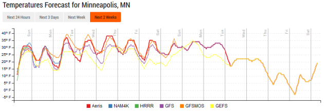
Highs will be in the 30s – and even potentially 40s – each of the next seven days. Fairly quiet weather in the temperature department, but this will allow our fresh, new snow to quickly start melting away.
After snow Saturday night into early Sunday, we will see quiet weather for the first half of the week as the next chance of precipitation (which will be in the form of rain and snow) doesn’t move in until Wednesday Night and moves in Thursday. A few more light snow chances appear in the long term, but it is certainly too early to really focus on any of them at the moment.
_______________________________________________
National Weather Forecast
Snow will be departing the upper Midwest during the morning hours Sunday. A cold front moving across the country will finally kick some of the heavy rain impacting the Southern Plains to Ohio Valley off to the south and east Sunday, with some snow possible across parts of Maine. Rain and mountain snow will continue in the Northwest.
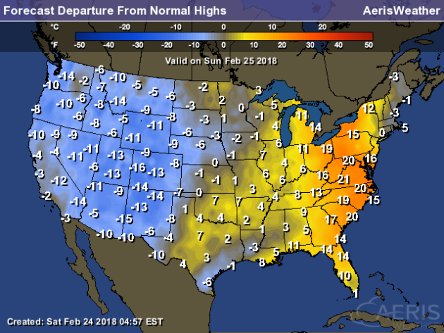
Warmth will be found out east ahead of the cold front Sunday, with highs a good 10-25 degrees above average from western New York into northern Florida. Cooler than average weather will be found in the western half of the United States, with highs that are up to 15-20 degrees below average across the Rockies.
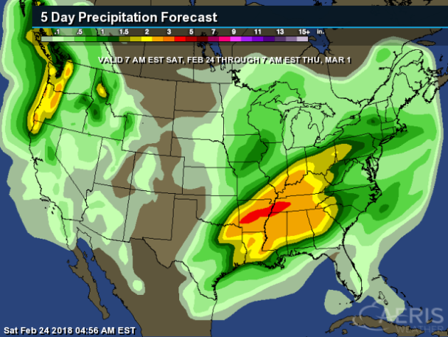
While the heavy rain that has been ongoing the past few days from the Southern Plains to the Ohio Valley will shift south heading into Sunday, another round of rain is likely toward the middle of the week that could continue flooding issues. Heavy precipitation – especially in the form of snow at higher elevations – will also be possible through Thursday morning in the Northwest.
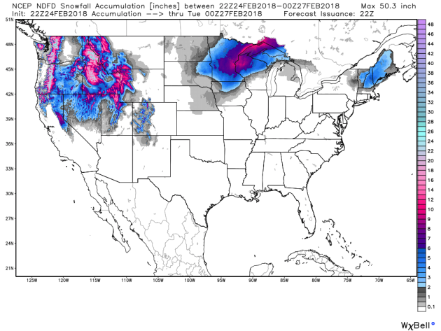
Heavy snow will continue though the end of the weekend and into early next week across the higher elevations in the Northwest, with feet of snow possible. Snow will continue through Sunday morning across the upper Midwest. Some light snow is expected Sunday in parts of New England, potentially totaling to a few inches.
_______________________________________________
Hurricanes Chance Coastal Sounds From Critters

Scientists this hurricane season noticed a chance in sounds from coastal critters after Maria and Irma passed over Puerto Rico. More from Science Daily: “Audio recordings of Hurricanes Irma and Maria’s passage over Puerto Rico document how the calls of coastal critters changed in response to the deadly storms. The hurricanes caused a major disruption in the acoustic activity of snapping shrimp, a reduction in insect and bird sounds, and potentially an intensification of fish choruses, according to new research presented at the Ocean Sciences Meeting Friday.” (Image: Hurricane Maria near peak intensity, moving north towards Puerto Rico, on September 19, 2017. New research shows Hurricanes Maria and Irma caused a major disruption in the acoustic activity of snapping shrimp and a reduction in insect and bird sounds in southwestern Puerto Rico. Credit: Naval Research Laboratory/NOAA.)
Where Is The Snow Out West?
That is the question many ski and snow lovers are asking out west this year. More from Earther: “Outside of the Northern Rockies and Washington State, the U.S. is desperately seeking snow. Hot, dry weather has been the norm for much of this winter in the West, setting the region up for a summer of water woes. The snow drought is most severe in California and the Southwest. California’s Sierra Nevada are averaging just 19 percent of their normal snowpack, trending in record-low territory. At the start of the water year, which began Oct. 1, there was nary a hint of drought to be seen in the Southwest. Now, nearly the entire region is in drought. The epicenter is right at the Four Corners, where extreme drought expanded this week to engulf 10 percent of the region, according to the U.S. Drought Monitor.”
Record February Warmth This Year
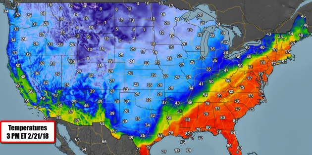
Numerous record highs – even all-time February highs – were broken in the eastern United States this week. Bad news: February’s will continue to get warmer. More from Popular Science: “Summer came early to New York City on Wednesday, as temperatures soared to a record 76 degrees Fahrenheit — more than 30 degrees warmer than the average February high. Up and down the the East Coast, from Atlanta to Baltimore to Cleveland to Boston, an unusual warm spell broke temperature records. While everyone enjoys t-shirt weather in February, this week’s mild weather is an ominous sign of global climate change. When heat makes history, it tends to bear a human fingerprint. Carbon pollution from cars, trucks, factories, farms, and power plants is trapping heat, driving up temperatures around the world. The result is more days of extreme heat and fewer days of extreme cold. Over the last year, the continental United States saw more than twice as many record highs as record lows.” (Image: 3 PM ET Temperatures Wednesday, February 21st, 2017 from AerisWeather)
_______________________________________________
Thanks for checking in and have a great Sunday! Don’t forget to follow me on Twitter (@dkayserwx) and like me on Facebook (Meteorologist D.J. Kayser)!
– D.J. Kayser

