62 F. high in the Twin Cities Saturday.
63 F. average high on April 25.
64 F. high on April 25, 2014.
April 25, 1996: Heavy snow over northern Minnesota. 10 inches of snow at Baudette. The International Falls airport closed for only the second time in history.

Slightly Windblown
April is, historically, the windiest month of the year for most Minnesota communities. According to climate historian Mark Seeley April 2015 has been particularly breezy: at least 9 days in the Twin Cities with winds gusting over 30 mph.
What does it mean? I’m not convinced we can read too much into this. Evidence of climate volatility or weather whiplash? Not necessarily.
The greater the swings in temperature the faster winds have to blow to keep the atmosphere in a state of equilibrium. We’ve seen sharp frontal passages, thus the uptick in wind speed.
The transition from winter to summer is always awkward, sometimes violent. As eager as we are for 80s and sticky, lake-worthy humidity levels, I’m not looking forward to curling up with a hot Doppler and tracking severe storms.
This is the calm before the (inevitable) storm.
Our big weather story: a warming trend is imminent. 60s give way to late-week 70s. The mercury may brush 80F next weekend before a cooler front sparks heavier rain early next week. A shower is possible Tuesday; heavier T-storms Friday & Saturday as warm, sticky air surges north. The atmosphere is shifting gears. Spring is finally here. No, really!
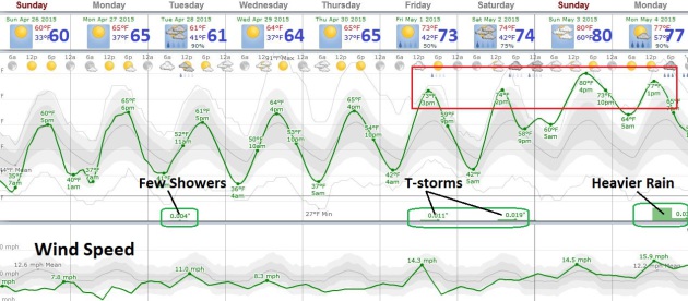
Progress. The fact that I’m now highlighting 70s and 80s means temperatures are (finally) lurching in the right direction. A good-looking week is shaping up as temperatures mellow; a few showers Tuesday with a better chance of T-storms Friday and Saturday as a surge of warmth pushes north. European guidance suggests heavier rain and strong T-storms early next week. Source: Weatherspark.
Jet Stream Buckles Into A Warm Ridge. Longer-range GFS guidance from NOAA shows a tongue of warm air pushing north as the week goes on, the best chance of 70s and even low 80s next weekend. Meanwhile unusually chilly weather lingers over New England. Source: AerisWeather.
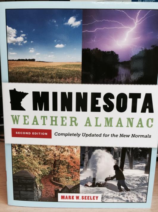
Windy April. Here’s an excerpt from this week’s edition of Minnesota WeatherTalk, courtesy of Mark Seeley (who has a new book out on Minnesota weather and climate). “As we have reported before, April is generally the windiest month of the year based on climate history from most Minnesota communities. But, April of this year has been particularly windy, with average wind speeds above the historical average, as well as a high frequency of wind gusts over 30 mph. Here is a list of average wind speeds and frequency of gusts over 30 mph for selected cities across the state:
Location Ave Wind Speed for April 2015 Number of days wind has gusted above 30mph
MSP 12.3 mph 9 days (peak of 46 mph on the 2nd)
Rochester 14.4 mph 14 days (peak of 47 mph on the 1st)
St Cloud 11.5 mph 8 days (peak of 49 mph on the 2nd)
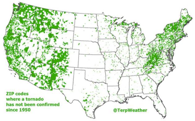
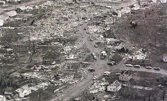
Tornado-Free U.S. Zip Codes Since 1950 On One Cool Map. Here’s an excerpt of an interesting article at weather.com, although as financial planners like to say, past performance is not an indicator of future returns: “Jordan Tessler, a geographer/amateur meteorologist in the Baltimore/Washington, D.C. area, tweeted the interesting map you see above, showing the U.S. ZIP codes without a confirmed tornado from 1950-2013, using data from NOAA’s Storm Prediction Center. There are a couple of caveats. The map does not imply the areas in green above have never seen a tornado, since it dates to only 1950. In decades past, some tornadoes in areas of lower population have gone undetected. Today, advanced radar technology, smartphones, social media and dense spotter networks make it increasingly rare a tornado is not documented...”
Map credit above: “Zip codes in the Lower 48 states without a confirmed tornado from 1950-2013, shaded in green.” (Jordan Tessler/@TerpWeather).
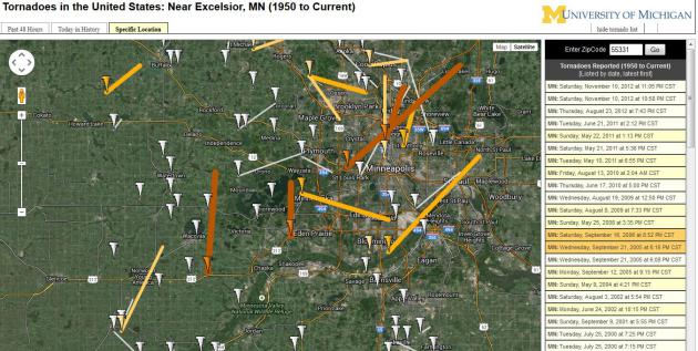
Tornadoes By Zip Code. The University of Michigan has a pretty cool tool that allows you to plug in a zip code to find all the tornadoes that have passed nearby. Worth a look.

How Alabama Made Tornado Helmets a Standard for Protection. My first choice is a form-fitted concrete-reinforced, form-fitted body cast that’s bolted to the floor. My second choice would be a helmet, for a variety of good reasons. AL.com is doing some terrific reporting on what is considered state of the art; here’s an excerpt: “…Earlier, AL.com, using the analysis of the UAB Injury Control Research Center that the best helmets for protection would be those that offer head, neck and face protection, listed the top helmets for protection:
1) An American Motorcycle Association-approved helmet with a full face shield providing head and neck protection is the top helmet and is easily accessible. But a good motorcycle helmet can cost many hundreds of dollars.
2) Football helmet. A football helmet is designed to protect the head and face, including the sides of the head. It should be one approved for full contact. A good football helmet can cost more than $200…”
Photo credit above: “Motorcycle helmets with face guards offer best protection like this one. Mike Culberson credits this helmet with preventing injury, if not saving his life, when his home roof collapsed during tornado in Fultondale, Ala., on April 27, 2011.” (Special/Michael Culberson).
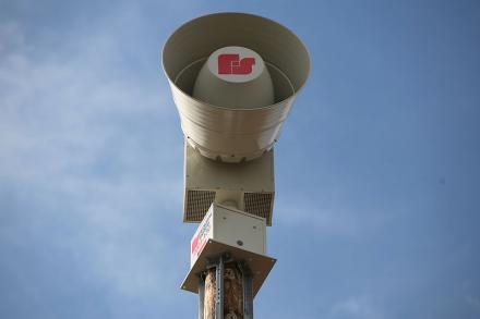
Special Report: Are Tornado Sirens Outdated Technology? The short answer is yes. Here’s a snippet from a story at wsaw.com: “…And the Langlade County Emergency Manager, Brad Henricks agrees. Because he said tornado sirens are not as reliable as you may think. “To mention if you can even hear it at 2 a.m. in the morning when severe weather approaches. Second problem, the sirens don’t tell you exactly what the threat is, there are better ways to get informed,” said Henricks. He said a new technology called a “Wireless Alert System” on your cell phone could be even more effective. That system sends important messages through your cell phone. It’s geographic specific. So if you are from Las Vegas visiting Wisconsin and if the activity is in range of your phone, you’ll get a text message…”
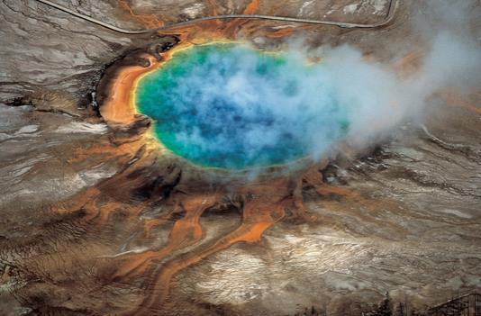
Scientists Find Missing Link in Yellowstone Plumbing: This Giant Volcano Is Very Much Alive. To paraphrase George Carlin, don’t sweat the thundershowers. And forget warming, if this baby goes of we’re talking nuclear winter for an extended stretch. Pray we don’t start issuing updates on Yellowstone anytime soon. Here’s a clip from The Washington Post: “Yellowstone National Park is the home of one of the world’s largest volcanoes, one that is quiescent for the moment but is capable of erupting with catastrophic violence at a scale never before witnessed by human beings. In a big eruption, Yellowstone would eject 1,000 times as much material as the 1980 Mount St. Helens eruption. This would be a disaster felt on a global scale, which is why scientists are looking at this thing closely…”
Photo credit above: “The gorgeous colors of Yellowstone’s Grand Prismatic hot spring are among the national park’s myriad hydrothermal features created by the Yellowstone super-volcano. A new University of Utah study reports discovery of a huge magma reservoir beneath Yellowstone’s previously known magma chamber.” (“Windows into the Earth,” Robert B. Smith and Lee J. Siegel).
The Army Is Testing Handheld Ray Guns. What was once science fiction is now scientific reality. Pretty amazing, and this new breakthrough makes your Taser look like a toy. Here’s an excerpt from DefenseOne: “…The military, too, has been experimenting with so-called energy weapons for decades, including lasers. “Most of these are vehicle-towed and require a huge power system,” Burke noted. “The antennas are sometimes seven feet.” The Burke Pulser, meanwhile, fits onto an M4 rifle like a standard suppressor. Burke estimates that the cost to mass-produce them would be less than $1,000 each. What do you do with an energy gun? You don’t shoot people. The gun is intended for use against electronics, potentially giving dismounted soldiers an edge against the ever-wider range electronic and cyber threats that they might face on patrol…”
Photo credit above: U.S. Army photo by Army Staff Sgt. Scott Griffin.

Bentleys Don’t Float: Exhibit A. Greg Hardy of the Cowboys got a weather lesson on Friday; here’s an excerpt from USA TODAY Sports: “Dallas Cowboys defensive end Greg Hardy was suspended 10 games by the NFL, and his week keeps getting worse. Hardy was involved in a “verbal altercation” with a teammate Friday at a Cowboys facility, and also ran into trouble while trying to drive along a flooded road. Severe storms in the area left thousands without power, and many roads and highways were covered in several inches of water. Hardy left his Bentley near Interstate 35 in Dallas, and it was later towed away...”
TODAY: Sunny and spectacular. Winds: NE 5-10. High: 61
SUNDAY NIGHT: Clear and cool. Low: 40
MONDAY: Partly sunny and mild. High: 65
TUESDAY: More clouds, passing shower possible. Wake-up: 44. High: 63
WEDNESDAY: Lukewarm sunshine. Wake-up: 47. High: near 70
THURSDAY: Warm sun. Too nice to work. Wake-up: 52. High: 75
FRIDAY: Clouds increase, late T-storm. Wake-up: 57. High: 74
SATURDAY: Mild sun, nighttime T-storms? Wake-up: 54. High: 76
Climate Stories…
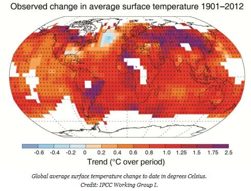
Warming Hiatus Will Not Stop Long-Term Global Climate Change. Factoring additional heat going into the oceans there hasn’t been a true hiatus in warming; here’s a clip from Sydney Morning Herald: “A recent hiatus in global temperature rises will not temper the ultimate impact of climate change by the end of the century, research by Australian climate scientists has found. In a study published in the journal Nature Climate Change on Thursday, the researchers compared different climate models – complex computer simulations used by scientists to project the impact of rising atmospheric concentrations of greenhouse gas...”
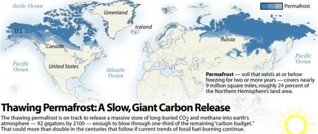
Thawing Permafrost: A Slow, Giant Carbon Release. InsideClimate News takes a look at what may wind up being the biggest climate tipping point: “…Kevin Schaefer, a permafrost scientist with the National Snow and Ice Data Center at the University of Colorado in Boulder and an author of the article, calls the thawing of the permafrost a “true climatic tipping point.” Scientists are still trying to pinpoint when it will happen, but Schaefer said that a likely point is around the middle of this century, when the Arctic changes from a carbon sink to a carbon source. When that happens, it will trigger a centuries-long, unstoppable feedback system, in which warming will release carbon, which will trigger more warming, which will release more carbon…”

Bob Inglis: Show Courage on Climate Change. Yes, finding ways to grow the economy and put more people to work, tapping more energy without relying on fossil fuels is America’s Energy Moonshot for the 21st century. Here’s an excerpt of an Op-Ed from former South Carolina (Republican) Congressman Bob Inglis at GreenvilleOnline: “America has an exceptional opportunity to prove that accountable free enterprise can solve climate change. The Great Recession dealt a blow to our confidence, but we’re coming back. If we boldly end all subsidies for all fuels and attach all costs to all fuels, liberty and transparent markets will spark consumer-driven innovation. In order for America to lead on climate change, the unconvinced need to be persuaded that achievable solutions can be found that fit with their values. Climate doomsayers have incanted a future full of fear. Climate naysayers have counseled a clutch of the fuels that have worked for us in the past…” (File photo above: Richard Shiro, AP).
