Windy November
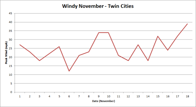
Even though spring is on average the windiest time of the year in the Twin Cities (with April the windiest month), we’ve been dealing with some quite windy conditions so far this month. Above is a plot of the top wind speed/gust recorded each day so far in November through Saturday, and almost every day has observed at least one wind report of over 15 mph. Fourteen of the eighteen days (through Saturday) this month have had a peak wind gust of at least 20 mph! The strongest wind gust so far this November – 39 mph – occurred Saturday at 1:09 pm.
_______________________________________________
Twin Cities Thanksgiving Climatology
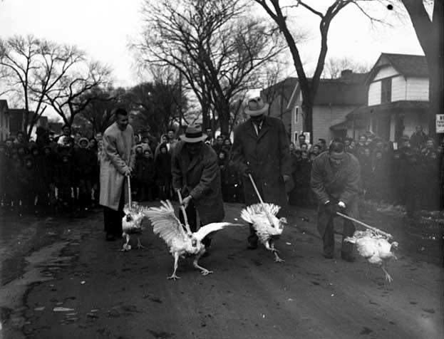
(Image: Turkey Race – 1955. Courtesy: Minnesota Historical Society)
The Minnesota State Climatology Office has put together some Thanksgiving climatology as we approach the holiday on Thursday. The warmest Thanksgiving on record was 62 back in 1914 and 1922, and we have only had a high of 50+ in the Twin Cities on Thanksgiving Day eleven times. Meanwhile, about one in five Thanksgiving have measurable snow that falls during the day, and about one in three have at least an inch of snow on the ground.
_______________________________________________
Almost Balmy Today – Good News for Travel Plans
By Paul Douglas
I talked to the Minnesota Farmers Union on Saturday. I’ve noticed a tangible change in attitude over our changing climate. In a decade the conversation has shifted from “I’m skeptical, prove it” to “I’m now seeing it in my fields – what do we do about it?”
The biggest risk for Ag in the Upper Midwest is more flooding rain event, extremes that wash away topsoil and nutrients. That said, we will be better off than much of the southern USA.
What a year it’s been: 8 percent of the U.S. population was impacted by floods, hurricanes and wildfires. 4.7 million Americans have registered for aid. Last year that number was 480,000 people.
The mercury may brush 50F today before tumbling back into the 30s for Tuesday, but any cold fronts into next week will be garden variety. Nothing yelp-worthy is brewing in the boreal wastelands of the Yukon, destined to punch our ticket. Flurries are possible Wednesday, but no storms capable of travel headaches into next weekend. I know, too good to be true.
NOAA models still hint at a mild December here. A white Christmas this year? Stay tuned.
_______________________________________________
Extended Twin Cities Forecast
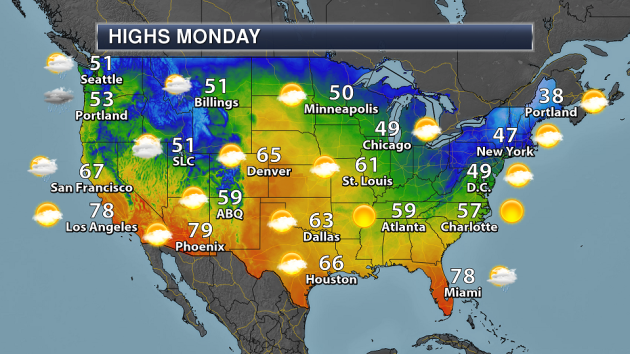
MONDAY: Mild sun, just fine. High 50. Low 25. Chance of precipitation 10%. Wind SW 8-13 mph.
TUESDAY: Gusty and colder, scrappy clouds. High 33. Low 18. Chance of precipitation 20%. Wind NW 15-30 mph.
WEDNESDAY: Clouds increase, flurries north? High 35. Low 26. Chance of precipitation 30%. Wind SW 7-12 mph.
THURSDAY: Giving thanks for 40F. Say what? High 41. Low 32. Chance of precipitation 10%. Wind E 5-10 mph.
FRIDAY: Milder, few PM rain showers. High 52. Low 32. Chance of precipitation 50%. Wind SW 8-13 mph.
SATURDAY: Mix of clouds and sun, cooler breeze. High 39. Low 22. Chance of precipitation 20%. Wind NW 8-13 mph.
SUNDAY: Dry roads, heaping serving of sun. High 34. Low 27. Chance of precipitation 10%. Wind SW 5-10 mph.
_______________________________________________
This Day in Weather History
November 20th
1996: Heavy snowfall accumulations of four to eight inches blanket much of Central Minnesota. Some of the heavier amounts included 8 inches at Montevideo and Gaylord, along with 7 inches at St. James, Mankato, Madison and Stewart. Six inches was reported in the Twin Cities and Glenwood.
1953: Freezing rain hits parts of Minnesota. 3 inches of ice accumulates on wires at telephone wires at Lake Benton.
_______________________________________________
Average Temperatures & Precipitation for Minneapolis
November 20th
Average High: 38F (Record: 63F set in 1925)
Average Low: 24F (Record: -3F set in 1921)
Average Precipitation: 0.06″ (Record: 2.01″ set in 1975)
Average Snow: 0.4″ (Record: 8.0″ set in 1975)
________________________________________________
Sunrise/Sunset Times for Minneapolis
November 20th
Sunrise: 7:17 AM
Sunset: 4:39 PM
*Length Of Day: 9 hours, 21 minutes and 41 seconds
*Daylight Lost Since Yesterday: ~2 minute and 8 seconds
*Latest Sunrise At/After 7:30 AM: November 30th (7:30 AM)
*Earliest Sunset: December 5th-13th (4:31 PM)
________________________________________________
Minnesota Weather Outlook
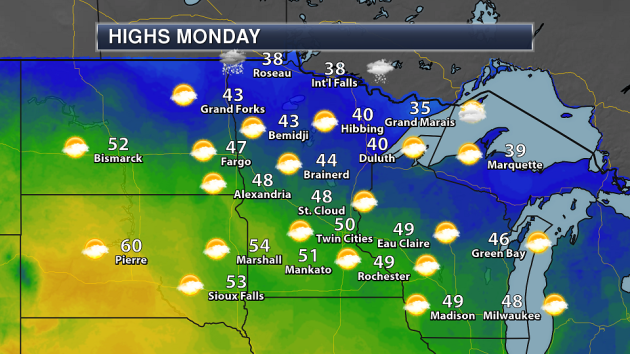
Most of the state will see nice weather as we head through Monday, with highs topping 50 across parts of southern Minnesota and a mix of clouds and sun. A few snow showers will be possible across far northern Minnesota as an Alberta clipper moves across southern Canada mainly late in the day. This will help bring in a push of colder air into the region Tuesday.
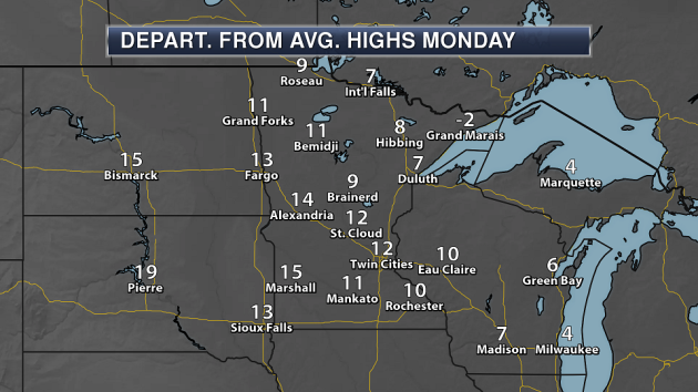
Highs across most of the state will be above average Monday – between 5-15 degrees above average for many locations.
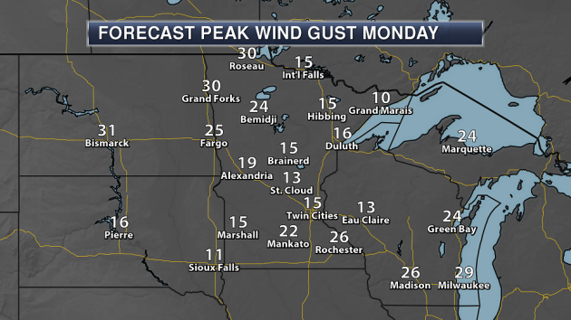
Winds will increase a little Monday, but the strongest winds will be across northwestern Minnesota, where gusts could top 30 mph.
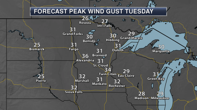
Blustery weather returns across the state Tuesday with the colder air in place. Wind gusts up to and above 30 mph will be common, making highs in the upper 20s in the Twin Cities feel even cooler.
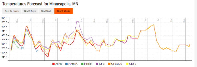
After highs around 50 Monday in the Twin Cities, we’ll be much cooler heading into the middle of the week – only reaching the 20s and 30s for afternoon temperatures. The push of warm air we had been monitoring for Thanksgiving Day looks to move in a little slower now – more in time for Black Friday shoppers. Highs Friday will climb into the mid/upper 40s, with some models hinting at the potential of 50s. We’ll see temperatures crash once again heading into next weekend.
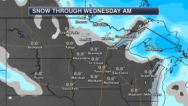
With that clipper system moving across southern Canada Monday, some light snow is expected across northern Minnesota. Snowfall totals are expected to remain under an inch.
While there is a few precipitation chances this week (one late Wednesday, another Friday and Friday Night), there isn’t too much moisture to work with for the Wednesday system, limiting the amount of precipitation that could fall (though if any does fall, it will be in the form of snow). A front moves through Friday and Friday Night, bringing a chance of rain into the region. Other than those currently slight chances, it looks like a fairly dry Thanksgiving week in the Twin Cities – one that will be perfect for travel.
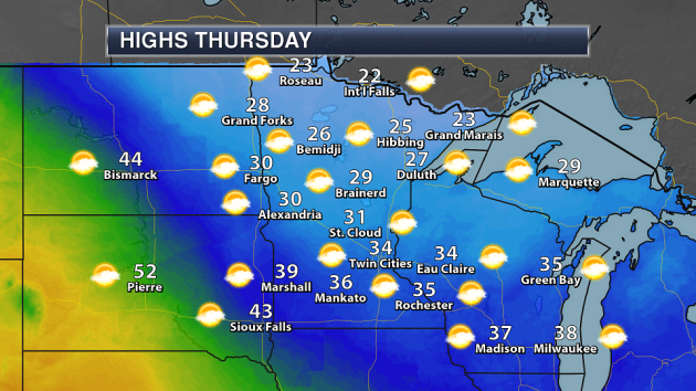
For Thanksgiving, temperatures will be in the 20s and 30s across the state with a mix of clouds and sun – not much to complain about, maybe even something to be thankful for!
________________________________________________
National Forecast
Rain and high elevation snow will continue across the Northwest Monday as a frontal system moves in and stalls out across the region. Some lake effect snow will be possible mainly early in the day down wind from Lakes Erie and Ontario. Meanwhile, a clipper system moving across southern Canada could bring parts of northern Minnesota some light snow by Monday night.
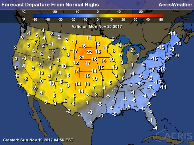
Temperatures Monday will be below average from southern Texas to the east coast – in some areas up to 15 degrees below average. Meanwhile, a warm bubble will be over parts of the Northern and central Plains, with highs over 20 degrees above average across parts of South Dakota.
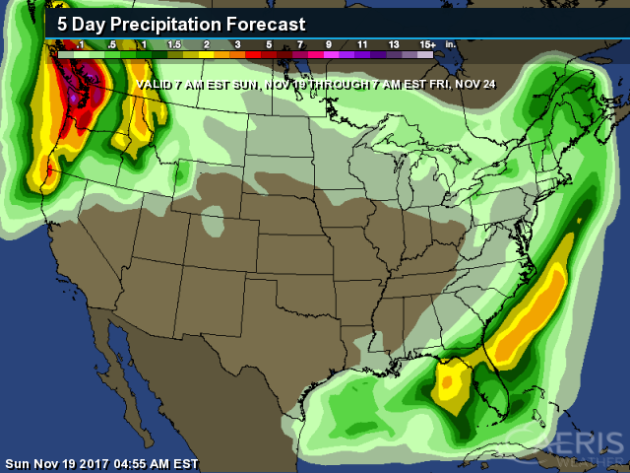
Rain will continue this week across the Pacific Northwest with multiple frontal systems bringing those chances to the region. We could see the potential of at least 3″+ of rain through Black Friday morning across this region.
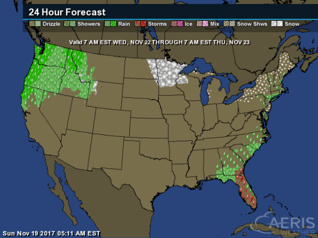
Taking a look to travel across the country for Wednesday, rain – heavy at times – will be likely across the Northwest as a cold front approaches. A few light snow showers will be possible in the upper Midwest, meanwhile a cold front will be moving off the east coast, bringing the chance of rain along the coast and into the Southeast, with some snow across New England.
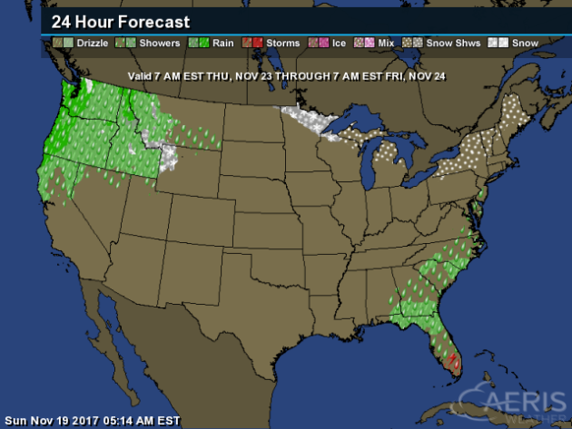
On Thanksgiving, that cold front will be pushing onshore in the Northwest, allowing for more showers across the region. Showers and storms will be possible across Florida with a stalled out front, with some snow possible across the northern Great Lakes and into parts of New England.
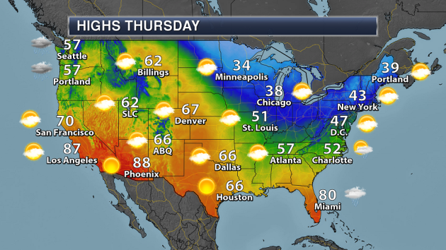
Cool weather will be likely from the upper Midwest to the Northeast for Thanksgiving, as highs will only be in the 30s and 40s. Meanwhile, temperatures will approach records in the Southwest.
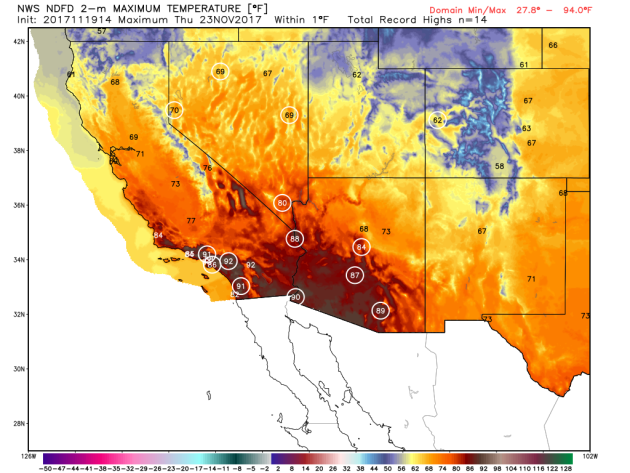
Numerous records across the Southwest can be expected on Thanksgiving, including Las Vegas, Phoenix and Tucson.
________________________________________________
The Weatherman Umbrella
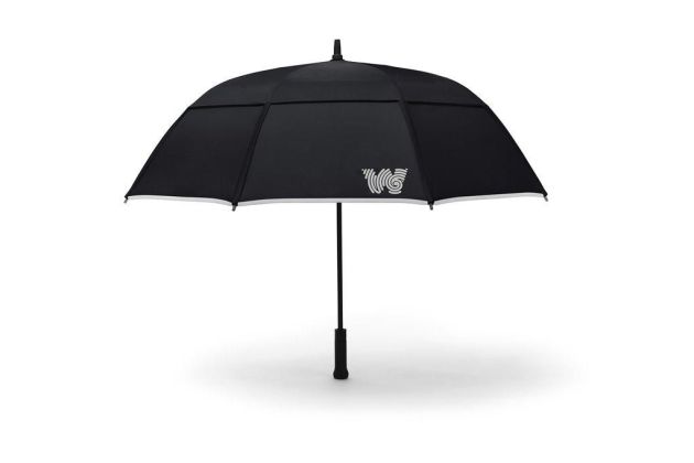
Don’t worry, this isn’t an umbrella just for meteorologists. It pairs up with an app to alert you when you should bring your umbrella with you (and locate it if you’ve lost it in your closet). It is also made so it isn’t easy to break. More from CNET: “The umbrella is made with 14mm gauge fiberglass ribs help prevent breaking and inverting inside out during strong winds, up to 55 mph. The umbrella fabric is coated with Teflon to repel the rain. The smart umbrella is backed by meteorologist Rick Reichmuth (hence the umbrella’s name Weatherman) who appears on “Fox and Friends” and “Fox News Sunday.””
Alaskan Ice Cellars
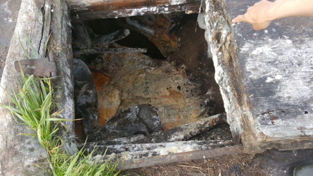
Native Alaskans have used ice cellars for centuries to help keep meat frozen. Climate change is complicating that, but modern technology is starting to be used to help monitor those cellars for changes in temperature. More from Earther: “The frozen soils on the North Slope have served Native Alaskans as natural freezer for centuries. Beneath the monotonous surface of the tundra, they’ve dug out chambers known as ice cellars that stay cold enough to keep whale and caribou meat frozen year round. Outstream Video “Its a cultural way of life for time immemorial,” Arnold Brower, head of the Alaska Eskimo Whaling Commission, told Earther. “We want to protect our harvested resources. That’s our lifeline.” But climate change is untethering that lifeline and a cultural connection that spans eons. Temperatures in the region are rising twice as fast as the rest of the world and it’s really screwing up life in Alaska. That includes ice cellars. While the great thaw won’t stop anytime soon, one young community member is working on a solution that will give people living across the North Slope a tool to make it more manageable.” (Image: The entrance to an ice cellar that flooded in Point Hope. Photo: Ianjon Brower)
Cleaner Air Might Start With Dirt
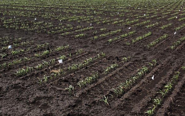
Sounds weird, right? More from Scientific American: “Soil management doesn’t sound snazzy, but scientists say it offers huge potential for keeping carbon emissions in the ground—and out of the atmosphere. A paper published this week in the journal Scientific Reports estimates that improved land-use practices could increase the amount of carbon stored in the top layer of soils worldwide by between 0.9 and 1.85 billion metric tons each year.” (Photo: PETROSS, TERRA-MEPP & WEST Flickr (CC BY 2.0))
______________________________________________
Thanks for checking in and have a great Monday! Don’t forget to follow me on Twitter (@dkayserwx) and like me on Facebook (Meteorologist D.J. Kayser)!
– D.J. Kayser

