Latest 100 In Twin Cities History
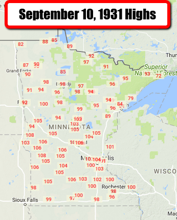
Sunday (September 10th) marks the latest 100 in Twin Cities history, when the thermometer reach 104 back in 1931. Highs reached 100 as far north as Detroit Lakes and Brainerd. Even places into the Arrowhead made it into the 90s, including 91 in Orr, 93 in Sawbill and 96 in Virginia.
_______________________________________________
Irma May Deliver Catastrophic Blow to Florida Gulf
By Paul Douglas
Here is what I hope to tell Brian Williams this morning during MSNBC coverage of Irma: every year we play the Weather Lotto. Most years we win (no big hurricanes). But hubris can be staggering when there’s a buck to be made. People want to live by water – and the market caters to that desire, even when it’s not sustainable. More people, building in risky flood zones, rising seas and a Category 4-5 hurricane? A toxic combination. I have a bad feeling about wind and storm surge damage from Naples and Ft. Myers to Sarasota and Tampa Bay, the most flood-prone metro area in the USA.
And I also think this might be the wrong time to be chopping NOAA’s budget by 17 percent. We need to be excelling at hurricane research & ensuring America’s weather models are the best in the world. Just saying.
Minnesota’s weather remains a happy afterthought, with a lazy high pressure bubble treating us to dry weather into next Wednesday. Storms late next week mark the arrival of another inevitable cool front.
Don’t whine. The ECMWF brings another hurricane close to the Carolinas in about 7-8 days.
_______________________________________________
Twin Cities Extended Forecast
SUNDAY: Warm sun, very nice. High 80. Low 62. Chance of precipitation 10%. Wind SE 10-15 mph.
MONDAY: Partly sunny, summer rerun. High 82. Low 63. Chance of precipitation 10%. Wind SW 7-12 mph.
TUESDAY: Warm sunshine, break out the shorts. High 84. Low 64. Chance of precipitation 10%. Wind SE 7-12 mph.
WEDNESDAY: Plenty of hazy sun, wander outside. High 84. Low 63. Chance of precipitation 10%. Wind S 5-10 mph.
THURSDAY: Warm sun, T-storms possible north. High 82. Low 62. Chance of precipitation 30%. Wind S 5-10 mph.
FRIDAY: Wettest day, showers and T-storms. High 78. Low 63. Chance of precipitation 70%. Wind SW 8-13 mph.
SATURDAY: Drier, few PM pop-up showers? High 73. Low 55. Chance of precipitation 40%. Wind NW 8-13 mph.
_______________________________________________
This Day in Weather History
September 10th
2002: A late-season tornado strikes Albertville just after midnight .According to a damage survey conducted by NWS personnel, it touched down on the eastern edge of Cedar Creek Golf Course, then it moved straight east and dissipated in a city park just west of the railroad tracks. It completely tore the roof off of one home. Roofs were partially off a number of other homes, many attached garages collapsed, and a couple of houses were rotated on their foundation. About 20 homes were damaged, nine of which sustained significant damage.
1986: 3 inch hail falls in Watonwan County.
1947: Downpours fall across the Iron Range. Hibbing receives 8.6 inches in three hours.
1931: St Cloud experiences a record high of 106 degrees, and it reaches 104 degrees in Minneapolis.
1910: The shortest growing season on record in Duluth ends, with frost free days from June 14 to September 10 (87 days). Normally the frost-free season is 143 days.
_______________________________________________
Average Temperatures & Precipitation for Minneapolis
September 10th
Average High: 74F (Record: 104F set in 1931)
Average Low: 55F (Record: 37F set in 1917)
Average Precipitation: 0.11″ (Record: 2.08″ set in 1913)
________________________________________________
Sunrise/Sunset Times for Minneapolis
September 10th
Sunrise: 6:46 AM
Sunset: 7:32 PM
*Length Of Day: 12 hours, 49 minutes and 41 seconds
*Daylight Lost Since Yesterday: ~3 minute and 4 seconds
*Next Sunrise At/After 7 AM: September 22nd (7:00 AM)
*Next Sunset At/Before 7:30 PM: September 11th (7:30 PM)
_______________________________________________
Minnesota Extended Forecast
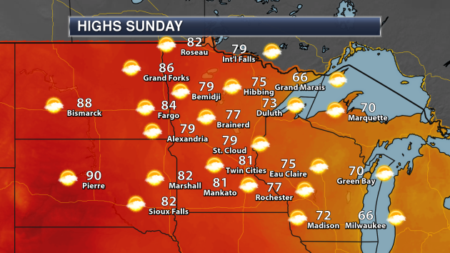
Sunday will be another gorgeous day across the state of Minnesota, with mainly sunny skies expected. Highs will be in the 70s to low 80s in many locations across the state. The cooler spots will be found near the North Shore of Lake Superior.
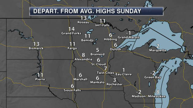
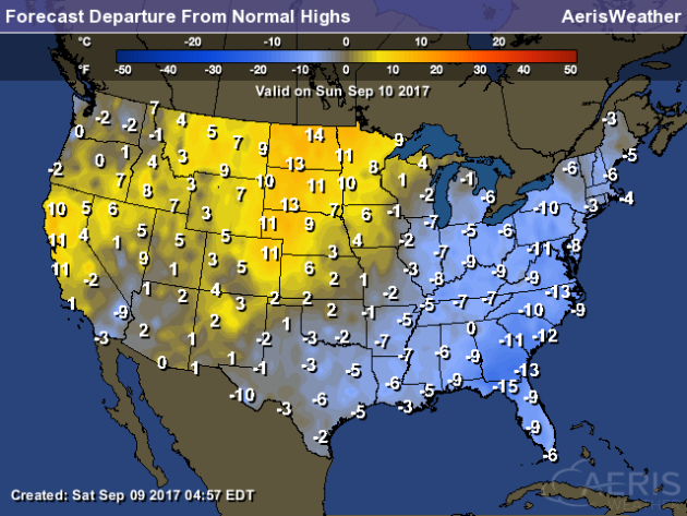
Highs across the state Sunday will be above average in most locations, with highs about 5-10 degrees above average across southern and central Minnesota, and approaching 15 degrees above average in parts of northwestern Minnesota.
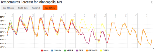
Temperatures will stay warm over the next several days, with highs in the low to mid 80s into the middle of the week. Highs will then back off a little (into the 70s) heading into next weekend.

We aren’t expecting any rain chances in the Twin Cities until the end of the week into next weekend with a front passing through.
_______________________________________________
Excerpt From Praedictix Briefing On Hurricane Irma
Here’s an excerpt from the Praedictix briefing that was sent to its corporate clients Saturday morning on Irma:

Graphic: AerisWeather
NAM Solution. The latest forecast from the American NAM model shows the eye of Irma passing over the western Florida Keys tomorrow morning (with hurricane conditions expected tonight across the region), then moving along the southwestern coast of Florida during the day. This will place the center of the system near Tampa early Monday morning, similar to the official forecast from the National Hurricane Center. Irma will produce hurricane-force winds across most of the Florida peninsula as the system moves to the north-northwest, with the strongest of winds focused in areas of the Florida Keys as well as southwestern and western Florida. In those areas where the strongest winds are expected, we could see gusts over 120 mph.
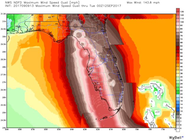
Potential Peak Wind Gusts. Most areas of the Florida peninsula are expected to see hurricane-force winds (74+ mph) Sunday into Monday. The strongest wind gusts from Irma are expected across western Florida, with wind gusts of 110-140+ mph possible from the Florida Keys to Tampa. Areas like Orlando and Miami are expected to see peak winds around hurricane-force.
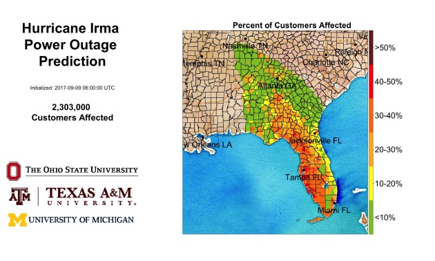
Power Outages Likely. Forecasting power outages can be tricky, but a joint effort from three universities shows the potential that over 2 million power customers could lose power from Florida into Tennessee from Irma. Widespread outages will be possible across Florida, especially across western Florida (including the Tampa area) due to the potential of 100+ mph winds.
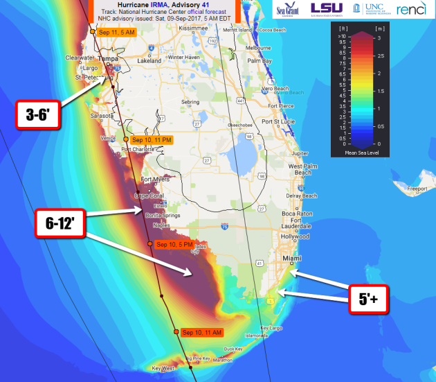
Storm Surge Potential For Southern Florida. With the westward track of Irma, the worst storm surge will impact parts of southwestern Florida, where a 6-12 foot rise is possible, especially if it coincides with high tide. We could see widespread coastal damage due to this flooding, as well as winds in excess of 100 mph. Storm Surge Warnings are in effect from the Volusia/Brevard county line southward around the Florida peninsula to Chassahowitzka, including the Keys and Tampa Bay. Water rises in the Tampa Bay area are currently expected to be in the 3-5 foot range, which would flood low-lying areas.
_______________________________________________
More On Irma
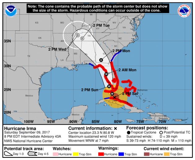
Irma is expected to strengthen some as it moves over the Florida Straits Saturday Night into Sunday, moving along the western Florida coast as a major hurricane on Sunday, capable of destructive winds, storm surge, heavy rain and tornadoes. It’ll be around the Tampa Bay area by early Monday morning and move into southern Georgia still as a hurricane (although a weaker one) by Monday afternoon.
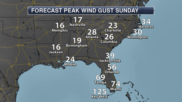
Winds will gust over 120 mph in Key West Sunday as Irma moves across the western Florida Keys. Winds will also be picking up in Miami (to hurricane-force) and across the rest of Florida. The strongest winds for Tampa won’t occur until Sunday Night.

Winds could gust over 120 mph at times in Tampa Sunday Night as the eye moves close to the city. Winds in Orlando and Jacksonville will pick up as well, gusting over 60 mph at times.
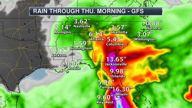
Parts of Florida will receive over a foot of rain across Florida in association with Irma as the system moves across the state. Heavy rain will continue to be possible along the path of the system into Georgia and Tennessee, with over 6″ of rain possible in Atlanta and 2-4″ across parts of Tennessee.
Irma And GOES-16
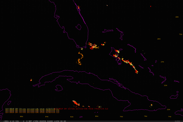
Irma was impacting the Cuba coast Saturday morning, and GOES-16 satellite imagery caught the system. Read and see more images from CIMSS. Image above: “The latest Geostationary Lightning Mapper data over the storm as the sun rises (Saturday), shows little lightning over the center of Irma.”
Debunking Irma Rumors

FEMA is trying to help debunk rumors about Hurricane Irma. More from Gizmodo: “Accurate information can be the difference between life and death during a hurricane. So FEMA has launched a new webpage in an effort to debunk rumors that people might be hearing about Hurricane Irma as the historic storm barrels down on the US mainland.” (Image: More than 150 cots sit in a gymnasium for FEMA and first responders who will be assisting Hurricane Irma relief efforts, Sept. 8, 2017, at Moody Air Force Base, Ga. (U.S Air Force photo by Airman Eugene Oliver))
Cell Networks And Irma
Will cell networks survive Irma? That’s a question that some are asking right now with the very strong wind gusts expected. But the nations wireless carriers are preparing. More from CNET: “Just two weeks after Hurricane Harvey barreled into the Gulf Coast of Texas, residents in Florida are bracing for Hurricane Irma, the biggest storm the state has faced in more than 20 years. Cellular service held up better during Harvey than in past storms, which is surprising given the scope and size of the disaster. But it’s unclear if the networks will be able to stand up to the larger, and potentially more destructive, Irma.”
_______________________________________________
National Weather Outlook
Sunday Forecast
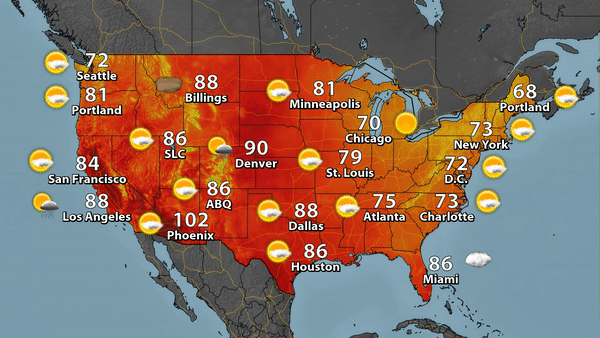
While Irma dominates the headlines, we are watching an upper-level low off the California coast. That will help bring in some moisture that could produce few showers and storms across the Southwest Sunday. Most of the rest of the country will see a mix of clouds and sun, with some smoke possible out west. Highs will only be in the 60s for parts of Maine.
The Northern Plains to the California coast will see above average highs on Sunday, ranging from 5-15 degrees above average. Areas from Texas to the Northeast will see cooler than average temperatures, including in Florida.
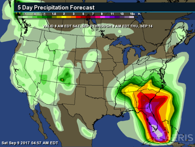
Through Thursday morning, the heaviest rain across the country will be in the Southeast, courtesy of Hurricane Irma. Not much rain is expected to fall in other areas, with most receiving less than an inch. The heaviest totals outside the Southeast/Mid-Atlantic will be in the mountains of Colorado, where isolated 2″ amounts are possible.
_______________________________________________
Hurricanes Good For Dolphins

While hurricanes are certainly not good for humans, there is one mammal that they are apparently good for: dolphins. That’s at least according to a study that showed there were more baby dolphins in the Gulf of Mexico in the years after Katrina. Part of it is nature-related, but it was also partly because there were less fishing vessels. More from Scientific American: “Biologist Lance Miller noticed something odd while conducting dolphin surveys in the Gulf of Mexico in 2007: baby dolphins. Lots of them, and lots more than he expected given the results of surveys in 2005 and 2006. The reason? Hurricane Katrina. Hurricanes like Harvey, the one that devastated Houston and other parts of Texas last week, and like Irma, the one currently threatening Florida, are typically associated with loss of life, loss of property, and other economic losses, the effects of which can be felt for years. That’s not only true for humans. It’s true for wildlife too.” (Image: NASA)
Numerous Record River Levels From Harvey In Texas
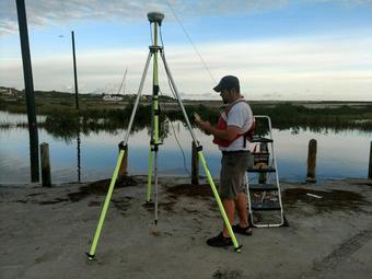
Want to know how historic the flooding from Harvey was in Texas? About 40 streamgages set new record peaks. More from the USGS: “Rivers and streams reached record levels as a result of Hurricane Harvey’s rainfall, with about 40 U.S. Geological Survey streamgages measuring record peaks. “During the peak period of flooding, about 81 streamgages in east and southeast Texas recorded water levels at National Weather Service flood stage,” said Jeff East with the USGS Texas Water Science Center. “All Texas rivers have already crested and have reached their highest levels.”” (Image: USGS scientist Alec McDonald surveying high water marks from storm surge from Hurricane Harvey at Packery Channel near Corpus Christi, Texas.(Credit: Vidal Mendoza, USGS. Public domain.))
Trying To Get Drought Aid For North Dakota

Governor Doug Burgam of North Dakota is trying to get money for drought relief from the U.S. government. More from the Bismarck Tribune: “Gov. Doug Burgum says he has met with federal officials to advocate for drought relief for North Dakota. Burgum says he met Thursday with U.S. Secretary of Agriculture Sonny Perdue and U.S. Secretary of the Interior Ryan Zinke. Burgum made a request on Aug. 8 for a presidential major disaster declaration for drought. That request is still pending.”
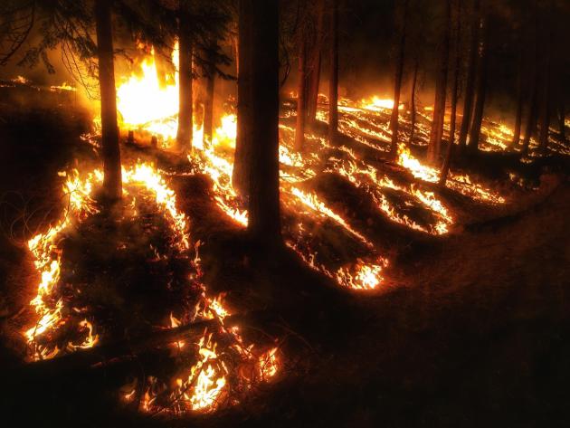
An Extreme Fire Season In Montana
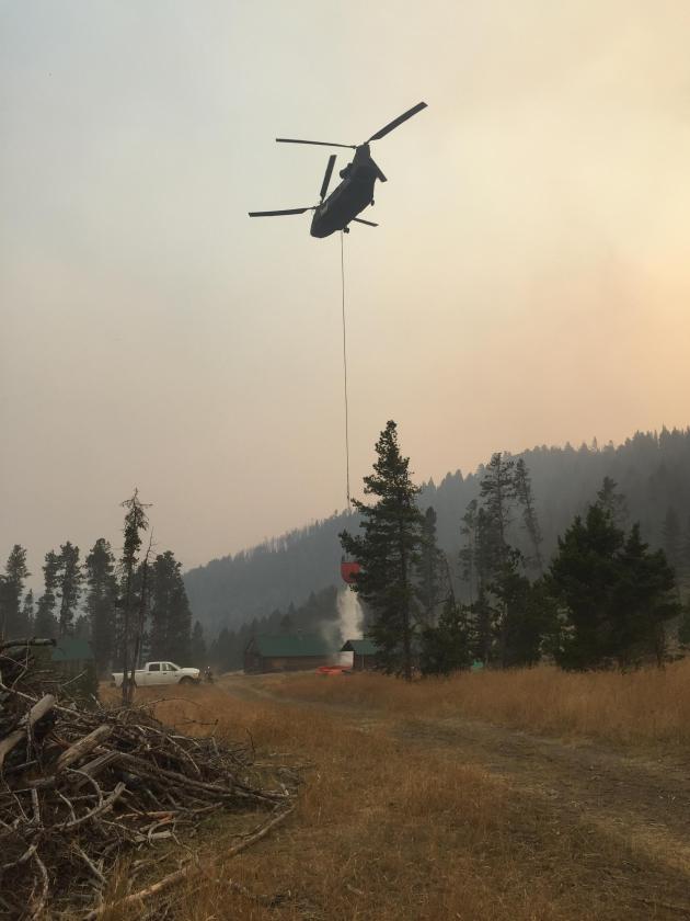
Over a million acres of Montana have burned in wildfires so far this year. More from the Great Falls Tribune: “In summing up the 2017 fire season, John Tubbs gets right to it: “There’s a lot of fire out there.” More than a million acres burned, to be clear. Tubbs, director of the Montana Department of Natural Resources and Conservation, isn’t wrong. Fires are burning across the entire state, the price tag is growing steeper, well-placed faith has been placed on rural fire departments in the east, suppression looks impossible in the west and the looming threat of wind is ever-present.” Image: Alice Creek Fire (Inciweb)
Dead Trees Pose Issues Out West
Dead trees out west are causing issues for firefighters trying to tackle wildfires. More from the Seattle PI (via the AP): “Vast stands of dead timber in the Western U.S. have forced firefighters to shift tactics, trying to stay out of the shadow of lifeless, unstable trees that could come crashing down with deadly force. About 6.3 billion dead trees are still standing in 11 Western states, up from 5.8 billion five years ago, according to U.S. Forest Service statistics compiled for The Associated Press.” Image: High Cascades Complex in Oregon (Inciweb)
_______________________________________________
Thanks for checking in and have a great Sunday! Don’t forget to follow me on Twitter (@dkayserwx) and like me on Facebook (Meteorologist D.J. Kayser)!
– D.J. Kayser

