
____________________________________________________________
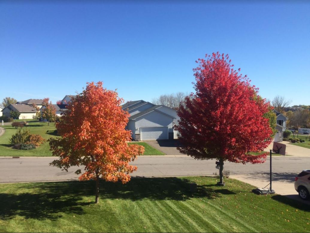
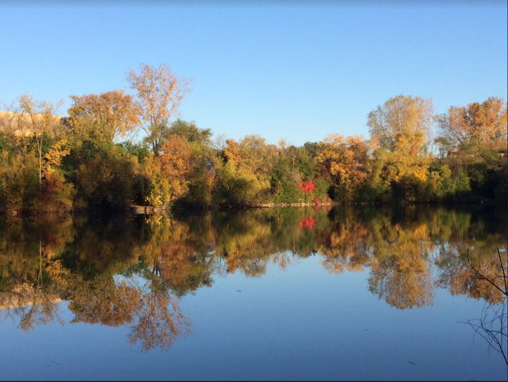
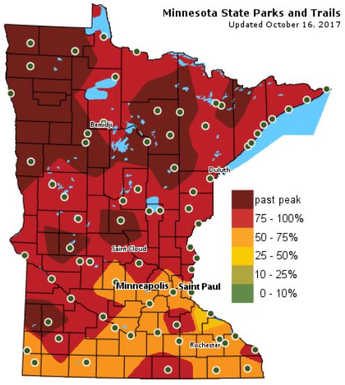
According the MN DNR, much of the state is seeing peak color right now with some spots across western and northern Minnesota already past peak!
Follow along as the fall colors change with the MN DNR map HERE:
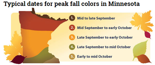
Typical Fall Color Peak in Minnesota
Here are the typical fall color peak times across the state of Minnesota and note that areas along the northern tier of the state usually see their peak toward the 2nd half of September. However, peak color usually doesn’t arrive in central Minnesota until October, but we’re getting close.
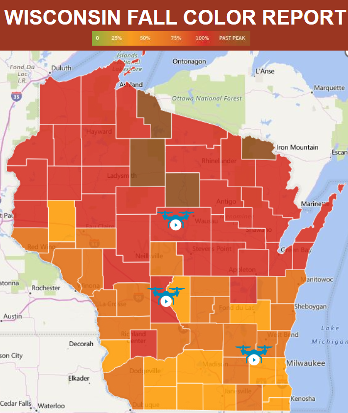
Wisconsin Fall Color Update
Colors are popping in Wisconsin too! In fact, much of the state is seeing peak color right now!
See more from Travel Wisconsin HERE:
_________________________________________________________________
Praedictix Briefing: Monday, October 16th, 2017
* Progress continues to be made on wildfires burning across California. While we will continue to see offshore winds the next couple days which will bring lower humidity values, winds are expected to be lighter. Temperatures will continue to remain warm, however.
* High pressure over the region will start to weaken Tuesday, bringing cooler temperatures and onshore flow. This will help to increase humidity values. A chance of rain also exists Thursday into Friday across the Bay Area.
* These weather conditions will help firefighters help contain at least 15 major wildfires across the state which have burned almost 220,000 acres and 5,700 structures.
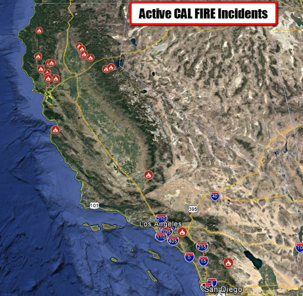
Map: CAL FIRE
Numerous Fires Continue Across California. While progress continues to be made on wildfires across the state, at least 15 major fires continue to burn (mainly across northern California). Some evacuation orders are being lifted across the region. You can view an interactive map of the active wildfires from CAL FIRE and view more information on individual fires.
Map: CAL FIRE
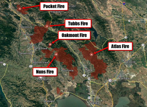
Central And Southern LNU Complex Fires. Some of the fires in the Central and Southern LNU Complexes are seeing containment being made, while fires like the Oakmont and Nuns continue to spread. Here’s the latest acres burned and containment from CAL FIRE as of last night:
- Central LNU Complex
- Tubbs Fire: 44,881 acres – 60% contained
- Pocket Fire: 11,889 acres – 30% contained
- Oakmont Fire: 575 – 15% contained
- Southern LNU Complex:
- Atlas Fire: 51,057 acres – 65% contained
- Nuns Fire (consisting of the Norbbom, Adobe, Pressley and Partrick fires as well): 48,627 acres – 40% contained
As of last night, here is the current situation on the fires according to CAL FIRE:
Tubbs Fire: The most active portion of the fire is still the north-eastern portion around Red Hill and Mount Saint Helena. The fire continues to make short uphill runs around to the north side of the peaks.
Pocket Fire: The fire continues to the east. Crews continue to make progress and increase containment.
Nuns Fire: Fire is progressing to north, spreading at a moderate rate. The fire is being driven by steep slopes and dry fuel.
Oakmont Fire: Fire was very active today, and is progressing in a northerly direction with moderate rate of spread.
Map: CAL FIRE
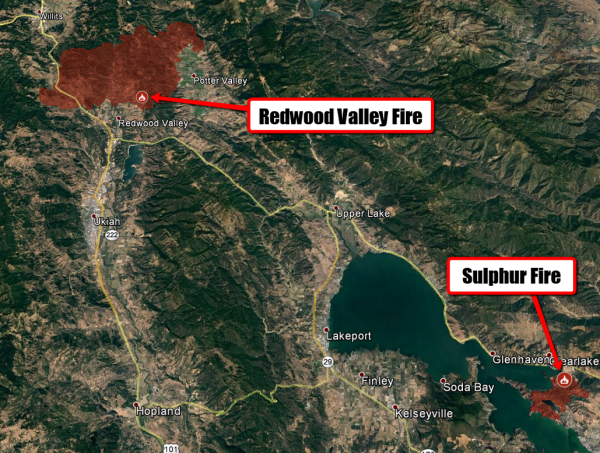
Mendocino-Lake Complex. Significant progress continues to be made on the fires in the Mendocino-Lake Complex, which contains both the Redwood Valley and Sulphur Fires. Approximately 900 people are still under evacuation orders due to the Redwood Valley Fire. Here’s the latest acres burned and containment from CAL FIRE as of last night:
- Redwood Valley Fire: 35,800 acres – 45% contained
- Sulphur Fire: 2,207 – 80% contained
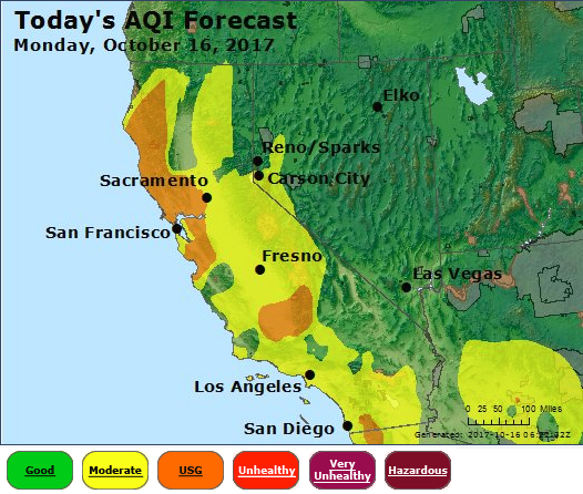
Image: AirNow
Air Quality Forecast Today. Air Quality will continue to be unhealthy, especially for sensitive groups, around the Bay Area today due to the smoke from wildfires. The Bay Area Air Quality Management District has once again issued a Spare the Air Alert for today. AirNow will have the latest current air quality readings as well as forecasts over the next several days.
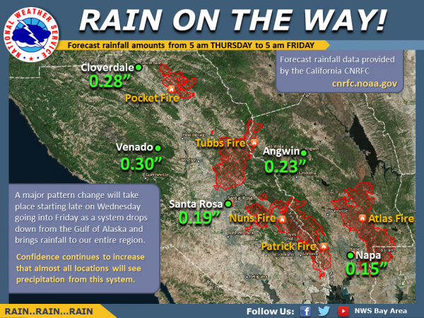
Late Week Rain. It appears likely that rain will spread over the Bay Area Thursday as a system drops out of the Gulf of Alaska. Rainfall totals could top a quarter inch in spots. This should help firefighters continue to battle fires across the region. However, be aware that there will likely be some slippery roads as well as this will be the first rain event of the season.
Meteorologist DJ Kayser
____________________________________________________________________
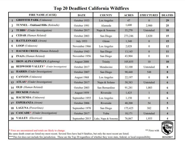
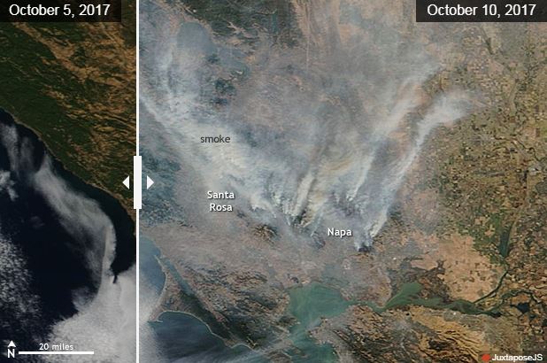
Top 20 Deadliest California Wildfires
According to CAL Fire, some of the ongoing wildfires have sadly become some of the deadliest wildfires in the states history. Note the TUBBS Fire has reportedly killed 18, which is considered to the be 3rd most deadly fire in the states history.
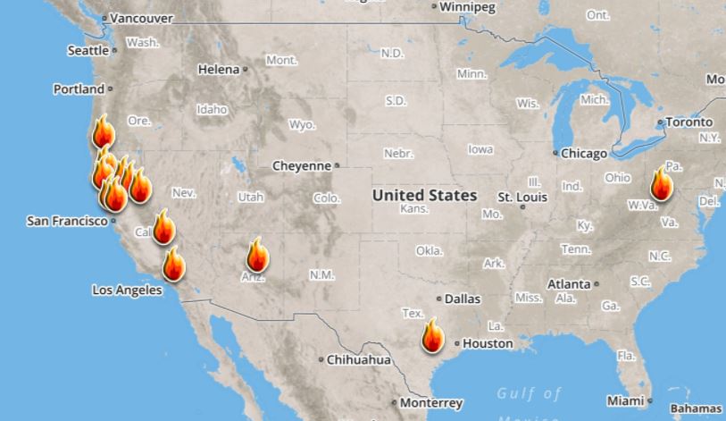
Here’s a look at the current wildfire map across the country. While several fires are still ongoing, recent cool and somewhat wet weather has been helping curb the wildfire threat, especially in the Western US.
Here’s a list of all the current large wildfires from Inciweb:
Atlantic Outlook Next 5 Days
.png)
___________________________________________________________
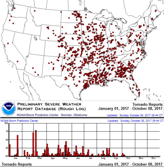
It certainly has been a fairly active first half of 2017 with 1,433 preliminary tornado reports through October 6th. Note that this is the most tornadoes through that date since 2011, when there were 1,815 reports. The map below shows the distribution of the tornadoes so far this year.
PRELIMINARY 2017 Tornado Count
According to NOAA’s SPC, the PRELIMINARY 2017 tornado count is 1,433 (through October 15th). Note that is the most active year for tornadoes since 2011, when there were 1,815 tornadoes. Keep in mind there was a major tornado outbreak in the Gulf Coast region from April 25-28, 2011 that spawned nearly 500 tornadoes, some of which were deadly. That outbreak is known as the Super Outbreak of 2011 and has gone down in history as one of the biggest, costliest and one of the deadliest tornado outbreaks in history.
.png)
_____________________________________________________________________
National Weather Hazards Ahead…
1.) High winds for coastal sections of Washington and Oregon, Wed-Thu, Oct 18-19.
2.) Heavy rain for the coastal Pacific Northwest and northern California, Tue-Fri, Oct 17-20.
3.) Heavy snow for the higher elevations of the Cascades, Wed-Fri, Oct 18-20.
4.) Heavy snow for parts of the Northern Rockies, Bitterroots, and Columbia Plateau Thu-Fri, Oct 19-20.
5.) Heavy rain for parts of western Washington and western Oregon, Sat-Sun, Oct 21-22.
6.) Heavy snow for parts of the Cascades, Bitterroots, Columbia Plateau, and Northern Rockies, Sat-Sun, Oct 21-22.
7.) Flooding occurring along the St. Johns and Withlacoochee Rivers across central Florida.
Flooding possible for part of southern Texas.
8.) Severe drought across parts of the northern Rockies, northern and central Great Plains, Midwest, and Hawaii.
.png)
_________________________________________________________
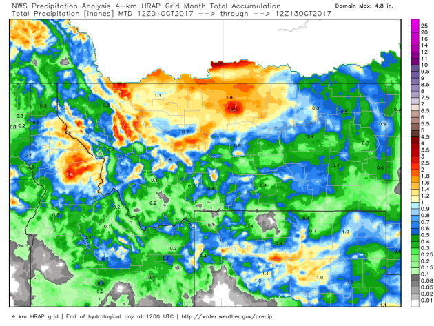
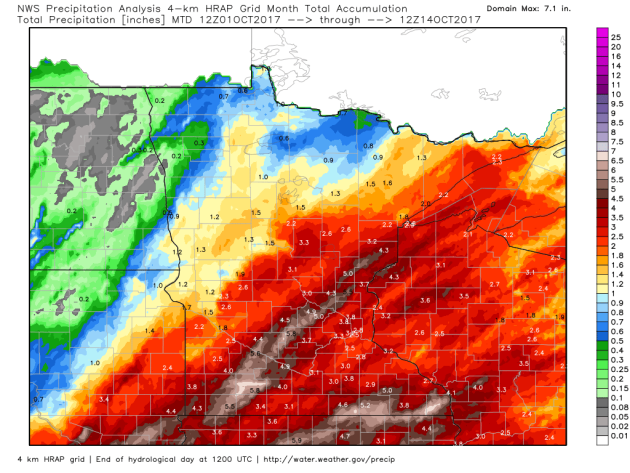
October Moisture in Montana
Thanks to a number of storm system, parts of Montana continue to pick up much needed moisture. Here’s a look at the estimated precipitation since the beginning of October, which suggests some 1″ to near 2″ tallies for some! While it’s not drought busting rain, it is drought denting… keep it coming!
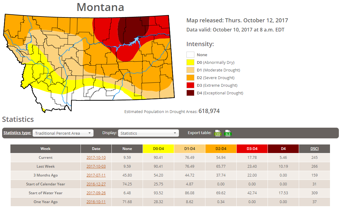
Latest Drought Monitor
Here’s the latest drought update from the US Drought Monitor, which shows EXCEPTIONAL drought conditions continuing across parts of Montana. Note that nearly 90% of the state is considered to be abnormally dry, but the EXCEPTIONAL drought covers nearly 5% of the state, which is down from nearly 10% from last week. We’re also seeing some improvement in the EXTREME drought, which is nearly 18% this week, down from near 23% last week.
 ____________________________________________________________________
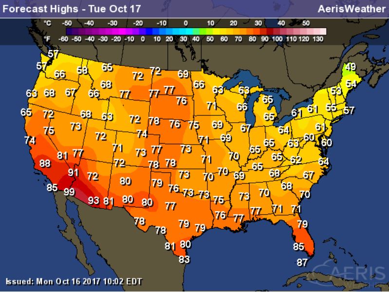
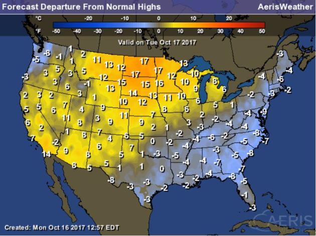
High Temps Tuesday
Here’s a look at high temperatures across the nation on Monday, which suggests that temperatures from the Northeast to Southern US will still be a little cooler than average with temps running 5F to 10F below average. However, temps from the Western US to the Great Lakes will be warmer than average, especially in the Midwest where temps could be 15F to almost 20F above average!
National Weather Outlook
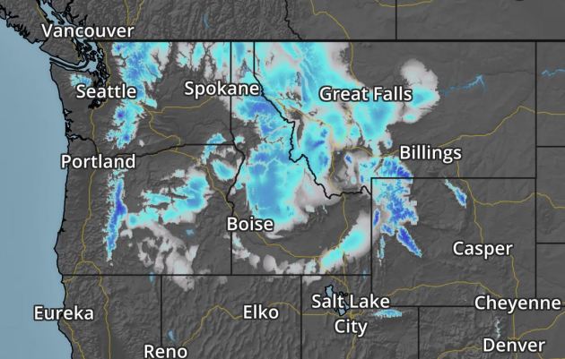
Here’s the weather outlook through the middle part of the week, which shows a cold front stalled across Florida with scattered showers and a few storms. Much of the nation remains quiet and dry with the exception of the Pacific Northwest where Pacfic moisture will begin to move into the region.
.gif)
According to NOAA’s WPC, areas of heavy rain will continue across parts of Florida, where a few inches of rain could fall through the end of the week. The heaviest precipitation over the next 5 day looks to be found in the Pacific Northwest, where several inches of liquid could fall across the high elevations there. The good news is that there appears to be some much needed precipitation across northern California, where wildfires continue.
.gif)
Snowfall Potential
.gif)
Snowfall Potential
.png)
By Paul Douglas
WEDNESDAY: Breezy with lukewarm sunshine. Winds: W 10-15. High: 70
THURSDAY: Blue sky. Hard to stay indoors. Winds: SW 7-12. Wake-up: 44. High: 68.
FRIDAY: Partly sunny. Feels like September. Winds: S 10-15. Wake-up: 53. High: 73.
_______________________________________________________
This Day in Weather History
October 17th
1971: Heavy rain falls in NW Minnesota. 4.02 inches is recorded at Georgetown (20 miles N of Moorhead).
1952: Record lows between 10 to 15 degrees are reported across central Minnesota, including a low of 10 at St. Cloud, 12 at Glenwood, and 14 at Alexandria, Litchfield, and Mora.
________________________________________________________
Average High/Low for Minneapolis
October 17th
Average High: 58F (Record: 84F set in 1910)
Average Low: 39F (Record: 22F set in 1952)
Record Rainfall: 1.24″ set in 1879
Record Snowfall: Trace set in 2004
_________________________________________________________
Sunrise/Sunset Times for Minneapolis
October 17th
Sunrise: 7:31am
Sunset: 6:24pm
Hours of Daylight: ~10 hours 52 mins
Daylight LOST since yesterday: ~3 minutes and 00 seconds
Daylight LOST since summer solstice (June 20th): 4 hours & 45 minutes
__________________________________________________________
Moon Phase for October 17th at Midnight
1.5 Days Before New Moon

_________________________
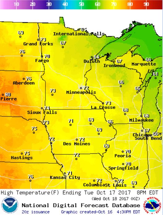
Highs on Tuesday will be VERY mild for mid October as highs warm into the 60s and 70s across the state. Note that 10F to almost 20F above average.
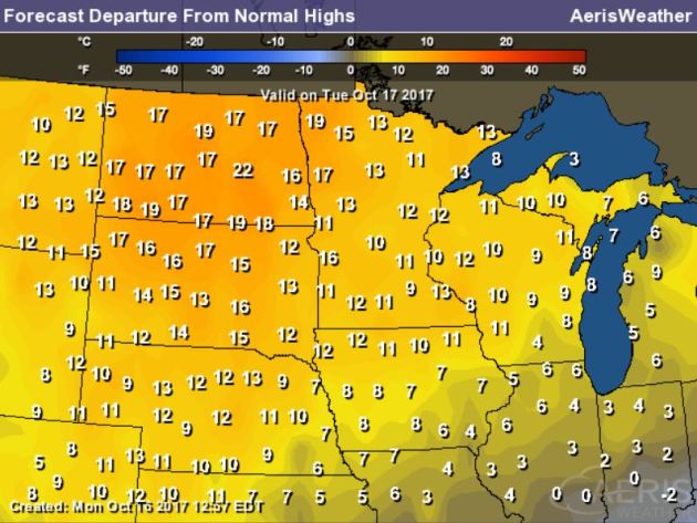
.gif)
Here’s the temperature outlook through October 31st, which shows very mild temps moving in through the 3rd full week of October. Temps could warm into the 60s and 70s, which 10F to almost 15F above average! Enjoy it because the extended forecast suggests MUCH cooler temperatures potential moving in by the end of the month. Stay tuned.
.png)
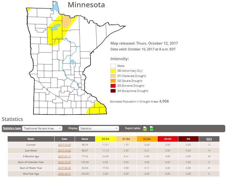
Minnesota Drought
According to the US Drought Monitor, much of the state is drought free, but nearly 11% of the state is considered to be abnormally dry with 1.3% in a Moderate drought, which is down from nearly 2.5% last week.
__________________________________________________________________
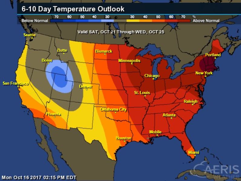
6 to 10 Day Temperature Outlook
According to NOAA CPC, there is a very good chance of well above average temperatures from October 21st to October 25th across much of the Midwest
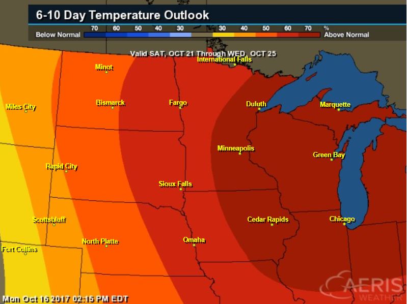
6 to 10 Day Temperature Outlook
According to NOAA’s CPC – much of the nation will remain above average with the exception of the Intermountain West, where cooler than average temps will be found
__________________________________________________________________
“President Donald Trump will nominate a climate change skeptic with ties to the fossil fuel industry to serve as a top environmental adviser. The White House on Thursday announced the selection of Kathleen Hartnett White of Texas to serve as chair of the Council on Environmental Quality. White served under former Texas Gov. Rick Perry, now Trump’s energy secretary, for six years on a commission overseeing the state environmental agency. White was fiercely critical of what she called the Obama administration’s “imperial EPA” and pushed back against stricter limits on air and water pollution. She is a senior fellow at the Texas Public Policy Foundation, a conservative think tank that has received funding from fossil-fuel companies that include Koch Industries, ExxonMobil and Chevron. In a 2014 policy paper titled “Fossil Fuels: The Moral Case,” White praised the burning of coal and petroleum for “vastly improved living conditions across the world” and credited fossil fuels with ending slavery. She also likened the work of mainstream climate scientists to “the dogmatic claims of ideologues and clerics.” White is a member of the CO2 Coalition, a group that seeks to educate “thought leaders, policy makers, and the public about the important contribution made by carbon dioxide to our lives and the economy.”

________________________________________________________
“Continued climate change will likely slash the Southwest’s summer monsoon rains, a new study says. The strong possibility that annual monsoon rainfall totals will drop 30 to 40 percent in this region by the end of the century if major steps aren’t taken to reduce greenhouse gas emissions is the take-home message of the study, written by researchers from Princeton and a federal weather agency among others. “If you think about our children, the next generation, the monsoon in general and where our water comes from will be fundamentally different for our children than it was for us,” said one of the study’s eight co-authors, Sarah Kapnick, a federal researcher who says that Western water issues are “what keeps me up at night. ”Southern Arizona monsoons are critical for the region’s water supply, producing more than half the Tucson area’s normal annual rainfall of about 11.5 inches. This past summer’s monsoon totaled 8.57 inches, well above the normal monsoon of about 6 inches. If the monsoon were to be slashed 40 percent, that would cut our total annual rainfall by about 20 percent. “It would have significant impact” on the Sonoran Desert, said Thomas Meixner, a University of Arizona hydrologist who was not involved in the study. “There would be less plant production, less food for animals, less water for them to drink.””
See more from Tucson.com HERE:
(Mike Christy / Arizona Daily Star VIA Tucson.com)
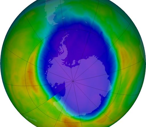
__________________________________________________________________“A NEW THREAT TO THE OZONE LAYER”
“High above Earth, more than 20 miles above sea level, a diaphanous layer of ozone surrounds our planet, absorbing energetic ultraviolet rays from the sun. It is, essentially, sunscreen for planet Earth. Without the ozone layer, we would be bathed in dangerous radiation on a daily basis. For more than 30 years, the Montreal Protocol has regulated ozone-destroying chemicals, allowing Earth’s ozone holes to heal and shrink. But there’s trouble on the horizon. An international team of researchers led by David Oram of the University of East Anglia has found an unexpected, growing danger to the ozone layer from substances not regulated by the treaty. The danger comes from a class of chemicals known as “chlorocarbons.” Dichloromethane is an example. It is used in paint stripping, agricultural fumigation, and the production of pharmaceuticals. Over the past decade dichloromethane became approximately 60% more abundant. “This was a major surprise to the scientific community and we were keen to discover the cause of this sudden increase,” says Oram. Developing economies in East Asia appear to be the source. “Our estimates suggest that China may be responsible for around 50-60% of current global emissions [of dichloromethane], with other Asian countries, including India, likely to be significant emitters as well,” says Oram.”
See more from SpaceWeather HERE:
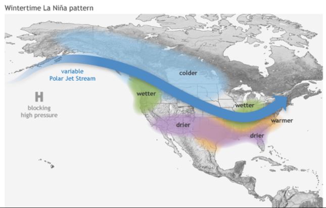
_________________________________________________________________“La Niña is expected this winter. What will that mean for our weather?”
_____________________________________________________________________
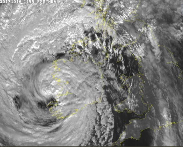
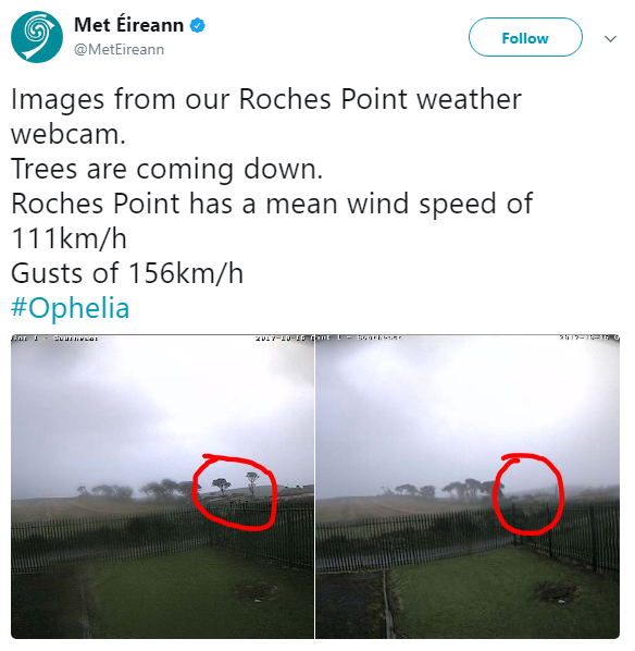
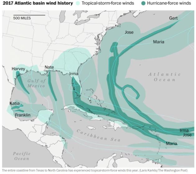
“The extreme 2017 hurricane season adds another remarkable record to its long list”
“Hurricane season still has 48 days left but it’s already one of the most terrible on record, which will be remembered for generations. Like other famous seasons — 1995, 2004 and 2005 to name a few — 2017 has had many storms and many significant landfalls. Impressive records keeping falling this year, the latest occurring this week when Ophelia became a hurricane in the eastern Atlantic. From Franklin to Ophelia, ten hurricanes have developed in the last 10 weeks, consecutively, tying a record for most hurricanes in a row. The last time this happened was way back in 1893. In an average season, we would typically have seen only five hurricanes by Oct. 13, along with five additional named storms of lesser intensity. This year — far from average — there have been 15 named storms from Arlene in April to Ophelia in early October.”
See more from WashingtonPost HERE:
__________________________________________________________________
______________________________________________________________________

