81 F. high in the Twin Cities Sunday.
81 F. average high on August 17.
82 F. high on August 17, 2013.
.22″ rain fell at MSP International Airport as of 7 PM Sunday
.
August 17, 1953: Four heifers near St. Martin were lucky; a tornado picked them up and set them back down again, unharmed.
Perpetual Thanksgiving
“I just want to celebrate – another day of living” sang Rare Earth in 1971. The older I get the less I take for granted. Like a wife who hasn’t kicked me to the curb in 30 years, great friends, and a father who just turned 84 – still able to travel & recall stories that leave me shaking my head in wonder.
With the daily challenges and setbacks of life it’s easy to lose sight of a simple truth: we were all very lucky to have been born in this time and place. Most of the planet would love to have our problems.
America is also home to the most severe weather on Earth. Why? No east-west mountain range like the Alps in Europe – nothing to block the movement of cold and hot; setting up a recipe ripe for meaty, momentous storms.
That temperature tango plays out overhead this week, sparking a Conga Line of storms. The NAM prints out 1-2 inches rain today; 90s and even a few 100-degree highs to our south over Iowa later this week. No blast-furnace heat here, but expect a muggy start to the State Fair with a few thundery lumps, especially Saturday. Canada flushes cooler, drier air south of the border by Sunday with a dew point in the 40s.
I wonder if Canadians complain about “American Air”?
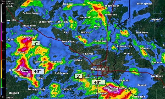
Sunday Soakers. As much as 4-5″ of rain was reported near Welch, far southeast metro, triggering flash flooding, even a few roads washed out from the sudden deluge. 1-2″ amounts were common over the far southern and southwest suburbs, with 4-5″ reported near Montevideo, nearly 4″ at Glenwood, from slow-moving thunderstorms. Doppler radar rainfall estimates courtesy of the MPX National Weather Service.
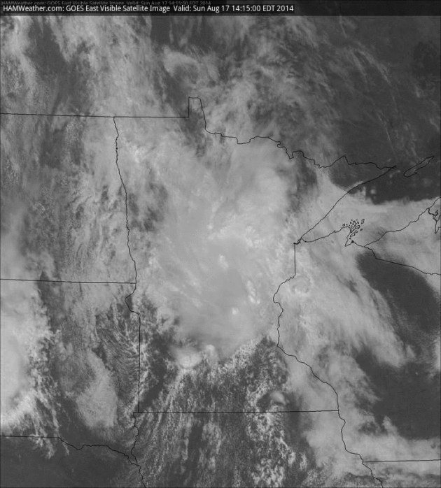
A Volatile Atmosphere. Drier air pushing southward (dew points in the 50s over northern Minnesota) created a sharp frontal boundary Sunday; dew points in the low 70s over much of southern Minnesota – truly tropical air. A cold twist of air aloft helped to ignite thunderstorms, and although they were below severe criteria, relatively slow forward motion created significant rainfall amounts south and west of the Twin Cities. More storms fire along that same boundary again today. Sunday afternoon visible loop: NOAA and HAMweather.
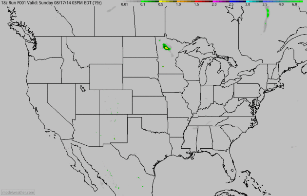
A Fleeting June Flashback. No, this won’t be a rerun of June, historically the wettest month on record, statewide, for Minnesota. But slow-moving storms will drop another 1-3″ of rain today, with the heaviest amounts south of the Minnesota River. Heavy showers and storms push into the Great Lakes, another swarm spreading from the Ohio Valley and Mid South into the Carolinas. 4 KM NAM accumulated rainfall: NOAA and HAMweather.
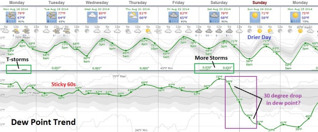
A Sticky Week – September Breeze by Sunday? Long-range guidance shows the best chance of showers and T-storms today; again Saturday. Expect a sticky week with dew point consistently in the 60s to near 70 thru Saturday, highs pushing well into the 80s again later in the week (probably warmer than displayed above, especially Thursday and Friday when mid and upper 80s are possible). European guidance suggests a sharp cool frontal passage late Saturday with dew points tumbling into the 40s, even some 30s by Sunday and Monday. Right now Sunday looks like the better/drier/sunnier, more comfortable day to troll the Minnesota State Fair.

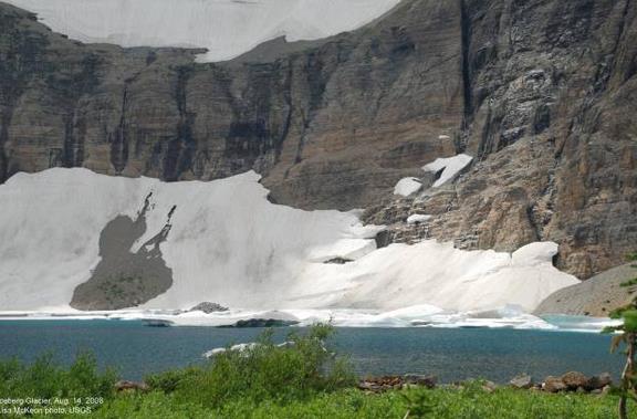
An End To The Midsummer Dry Spell over Southern Minnesota? Farmers were beginning to worry a bit, fearing another “flash drought” similar to August of 2013. Sunday’s rains helped alleviate some of those fears, and more heavy showers and storms today should put a dent in the recent dry spell. The Minnesota DNR explains that between June 15 and August 12 rainfall amounts over parts of southern MN were 2-5″ below average: “…As of August 12, the Drought Monitor shows that a small area of south central Minnesota has been categorized as “Abnormally Dry”. So why has the drought been slow to return to Minnesota? There are two main reasons. One is that this summer dry spell came on the heels of the wettest June on record for the state, and secondly it hasn’t been too warm. The preliminary statewide average temperature departure for July 2014 was the same as the Twin Cities at 2.3 degrees below normal. August so far has had a pattern of near normal temperatures, with a lack of extreme heat. So far for the Twin Cities, there have only been two days of 90 degrees or more. By this time in 2013 there were nine by August 14…”
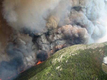
U.S. Forest Service Chief Talks Wildfires, Funding. Here’s some information I didn’t know, an excerpt of a story at The Desert Sun: “…We have 31 uncontained large fires in Idaho, California, Washington, Oregon and Montana. The number of fires compared to the past 10 years is a little bit lower. However, when you look at last year, where we had a very active fire season, we had fewer fires (at) this time than we have today. We’re seeing very large fires. Washington is having the largest wildfire in the history of the state. This tracks with what we’ve been seeing almost every year. There’s a new state record. Last year, (it) was California. The year before that it was New Mexico. Arizona two or three years ago set a record…”
File photo above: Reuters.

The Internet’s Original Sin. The inventor of (hated) pop-up ads talks about the transition from advertising to surveillance to monetize (free) web use. Or as I remind people if the service is free you’re the product. No, the NSA has nothing on Facebook and Google. Here’s an excerpt from a fascinating article at The Atlantic: “…The fiasco I want to talk about is the World Wide Web, specifically, the advertising-supported, “free as in beer” constellation of social networks, services, and content that represents so much of the present day web industry. I’ve been thinking of this world, one I’ve worked in for over 20 years, as a fiasco since reading a lecture by Maciej Cegłowski, delivered at the Beyond Tellerrand web design conference. Ceglowski is an important and influential programmer and an enviably talented writer. His talk is a patient explanation of how we’ve ended up with surveillance as the default, if not sole, internet business model…”
Image credit above: “Hendrik Goltzius’ “The Fall of Man” (1616)” (Wikimedia Commons).

TODAY: T-storms likely, locally heavy rain. Dew point: 70. Winds: SW 10. High: 81
MONDAY NIGHT: More T-storms, some heavy. Low: 66.
TUESDAY: More clouds than sun. Lingering storms, mainly over Wisconsin. High: 79
WEDNESDAY: Fading sun. Late night storms? Wake-up: 63. High: 81
THURSDAY: Steamy sun, almost hot. Dew point: 67. Wake-up: 66. High: 88
FRIDAY: Sticky sun, isolated storm. Dew point: 68. Wake-up: 69. High: 87
SATURDAY: Drippy humidity levels. More numerous T-storms. Dew point: 70. Wake-up: 70. High: 83
SUNDAY: Better Fair day. Cool sun, fresh breeze. Dew point: 42. Wake-up: 57. High: 73
Climate Stories…

Why Global Warming Leaves Most Of Us Cold. Confirmation bias, resorting to the Internet Echo Chamber and trying to please our peers; all compelling reasons to sit on our hands, in spite of compelling scientific evidence. So argues a story at Canada’s Maclean’s, a look at how our brains are wired to ignore climate change; here’s an excerpt that caught my eye: “…Most importantly, humans have evolved to deal with short-term dangers, where our rational and emotional brains work in tandem. But climate catastrophe is a long way off—in terms of human danger signals—and every specialist Marshall spoke to agreed that we have still not found a way to effectively involve our emotional brains in it. Deniers and believers are fully engaged, but most people are still in wait-and-see mode, with their rational brains aware there is a problem and their emotional brains looking about them to see how to respond. But “both of their brains are sufficiently detached that they do not have to deal with the problem unless actively compelled to do so...”
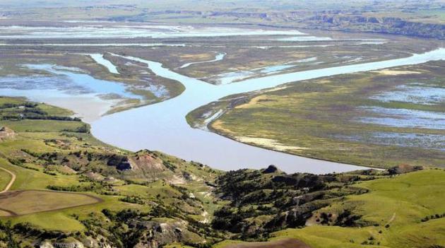
Climate Change Reflected in Altered Missouri River Flow, USGS Report Says. Here’s an excerpt from a story at The Los Angeles Times: “…Climate shifts may be causing the disparate changes in the Missouri River Basin, the USGS report says. The scientists noted that higher stream flow in the Dakotas had occurred even as water use increased. In addition, they said, lower stream flow in some areas could be related in part to groundwater pumping. “Understanding stream flow throughout the watershed can help guide management of these critical water resources,” said USGS hydrologist Parker Norton, lead author of the report that focuses on stream flow. The study is part of his doctoral research, which will analyze precipitation patterns, temperatures and their effects…”
Photo credit: “The Missouri River winds through the countryside near Williston, N.D. The river’s streamflow has changed significantly over the last 50 years.” (Charles Rex Arbogast / Associated Press).
