77 F. high in the Twin Cities Saturday.
80 F. average high on August 23.
88 F. high on August 23, 2013.
Trace of drizzle yesterday at MSP International Airport.
August 23 in Minnesota Weather History:
2006: Tornadoes and large hail strike southern Minnesota. One person died and 37 were injured when a strong tornado began 4 miles west-southwest of Nicollet in Nicollet County and move almost due east for 33 miles to near Waterville in Le Sueur County. Many storm chasers captured the tornado on video. The largest hail reported was grapefruit-sized at New Prague in Scott County.
1934: Early arctic blast across Minnesota. Rochester and Fairmont have lows of 34 degrees.

Fair Factoids
As bad as you think it is, it can always be worse. You think today will be hot? Not even close to what visitors to the Minnesota State Fair endured on September 10, 1931, when the mercury hit a blistering 104F. 2013 was the third hottest fair on record; 6 days above 90F. A few T-storms sprout later today, but it won’t rain nearly as hard as it did in 1977, when 9.5 inches soaked the fair.
According to the Minnesota DNR there have been chilly spells too. On September 13, 1890 the mercury dipped to a brisk 33F.
Big extremes, which makes sense. The State Fair captures the essence of Minnesota, including it’s head-shaking weather.
Avoid dressing in layers today: highs surge into the low 90s – the heat index later today may approach 100F. Strong storms mushroom by the dinner hour, marking the leading edge of cool, Canadian relief. But this fresh front stalls just to our south, sparking waves of showers Tuesday into Thursday. Highs may hold in the 60s and low 70s by midweek.
No worries. 80s return by next Sunday – a warmer than average September is expected.Summer came late, so will autumn.
And today a hot, vinyl car seat warning and small cooler advisory remains in effect.
Minnesota State Fair Weather. I thought this was an interesting overview of not only weather at the fair, but reasons why the Minnesota State Fair has been canceled in years gone by. Good reasons. Here’s an excerpt from the Minnesota DNR: “…The Minnesota State Fair has been held at its current site since 1885. There were some years when the fair was not held because of war, disease or logistical reasons. These years are: 1861 (Civil War) 1862 (Civil and Indian War) 1893 (Columbian Exposition) 1945 (fuel shortage because of WWII) and the last time the fair was not held was in 1946 due to an outbreak of Polio. Beginning in 1975, the fair has a 12 day run each year ending with Labor Day. Thus since 1975, the fair begins on a Thursday in August. Before 1975 the fair was held for shorter durations (eleven days from 1972 to 1974, ten days from 1939 to 1971, eight days from 1919 to 1938 and six days from 1885 to 1918)…”
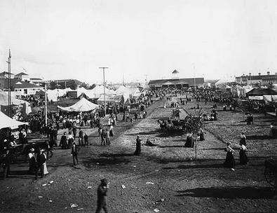
Photo credit above: “A Minnesota State Fair Scene around 1900.” Courtesy: Minnesota Historical Society.

Grounded. My wife is a Navy Blue Angels groupie (with a son who flies helicopters in the Navy I could see this coming). So yesterday we schlepped up to Duluth, enjoying the free MnDOT road repair entertainment (one guy with a shovel – creating a 5 mile back-up on I-35). Thank you! We got to Duluth late for the Air Show, only to discover fog, mist, drizzle and a cloud deck 400 feet above the airport. To fly safely a 1,000 foot cloud ceiling was required, and that just didn’t happen. We snapped a few photos, checked out the planes and exhibits, geeked out on Cirrus’s upcoming new personal jet aircraft (Vision SF50), and had a lovely steak sandwich. Note to self: as much as I love Duluth, it’s proximity next to a vast, chilled, fog-generating lake makes it a less than ideal venue for an air show. Just saying.
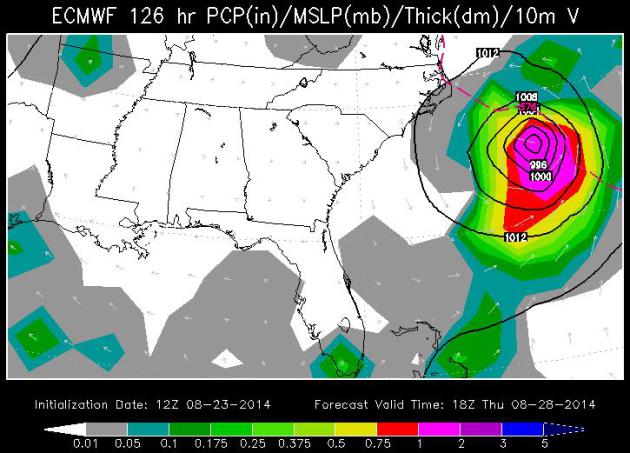
Hurricane Cristobal? Models are fairly consistent now spinning up a depression over the Caribbean into a tropical storm over the Bahamas, reaching Category 1 hurricane strength off the North Carolina coast late Wednesday and Thursday. Right now models (including the ECMWF/European above) keep the center of the storm out to sea; no landfall predicted – but serious rip currents and some beach erosion can’t be ruled out, especially Charleston and Wilmington to the Outer Banks. Forecast valid midday Thursday: WSI.
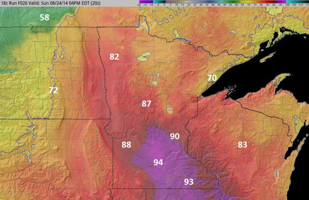
4 PM Today. Stratus clouds have been very persistent in recent days, the sun not high enough in the sky any longer to burn away the fog and low cloud cover, keeping temperatures 5-15F cooler than they would be otherwise. I expect a stiff south wind and T-storms sweeping across central and northern Minnesota to increase the potential for sunshine today, luring the mercury near or even above 90 from the Twin Cities on south by late afternoon. 4 KM NAM model guidance above: NOAA and HAMweather.
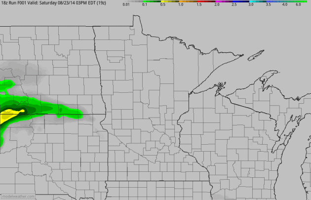
Will Storms Skip Over MSP? Future radar and derived accumulated rainfall tallies show heavy storms pushing across western and central Minnesota early today, another, second squall line developing this evening south and east of the Twin Cities. I wouldn’t bet the farm on this actually verifying. Stay tuned. 60-hour accumulated rainfall amounts: NOAA and HAMweather.
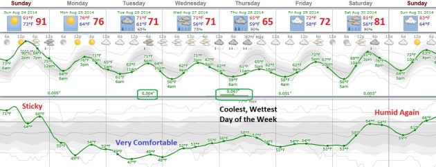
European Guidance. After sweating it out today models continue to show an influx of Canadian air much of this week, highs in the 70s and lows dipping into the 50s by midweek. Right now Thursday looks like the coolest, wettest day of the week; heaviest rains staying over far southern Minnesota and Iowa Tuesday into Thursday. Temperatures mellow into the 80s again next weekend, models hinting at mid-80s and sunshine on Labor Day. Feeling lucky? Me neither. MSP Meteogram: Weatherspark.
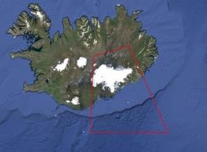
Iceland Volcano Experts: No Eruption Yet. As they say, the “situation is fluid”. As in magma-fluid, and at some point that lava may reach the surface, like an enormous, angry pimple. The impact to trans-Atlantic flights is still unclear, but if history is a guide there could be serious implications in the coming weeks. Here’s an excerpt of an update from a good source of local information, RUV: “…The most likely scenario is that an eruption has not begun. This morning we saw a large increase in seismic activity and tremors, so it was perfectly rational to assume that an eruption had begun. A subglacial eruption melts the ice and causes floods. We surveyed the glacier for three hours today. I can of course not assert that nothing has happened, but it is clear that there are no signs of abnormal melting or other signs that normally appear during a subglacial eruption…”
* The Icelandic Civil Protection Agency has continuous updates in a live-blogging format here.
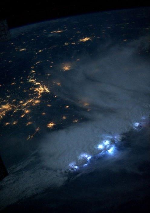
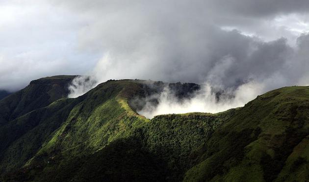
Spotty, Fickle Rains So Far in August. Dr. Mark Seeley has another good weather and climate-related time capsule and summary, proving perspective to our ongoing pattern. Here’s an excerpt of this week’s edition of WeatherTalk: “…As opposed to the widespread wetter than normal pattern that prevailed across the state during the first half of summer, August rainfall has been very spotty. The US Drought Monitor expanded the geographic designation for an abnormally dry landscape in Minnesota. Last week the designated area was Freeborn and Faribault Counties and this week the Drought Monitor designation for abnormally dry includes portions of Winona, Fillmore, Mower, Blue Earth, Waseca, and Le Sueur Counties. Heavier than normal rainfall for much of Minnesota is in the outlook for the remainder of August, so most areas should see some significant rainfall amounts before the end of the month…”
Image credit above: International Space Station, NASA.
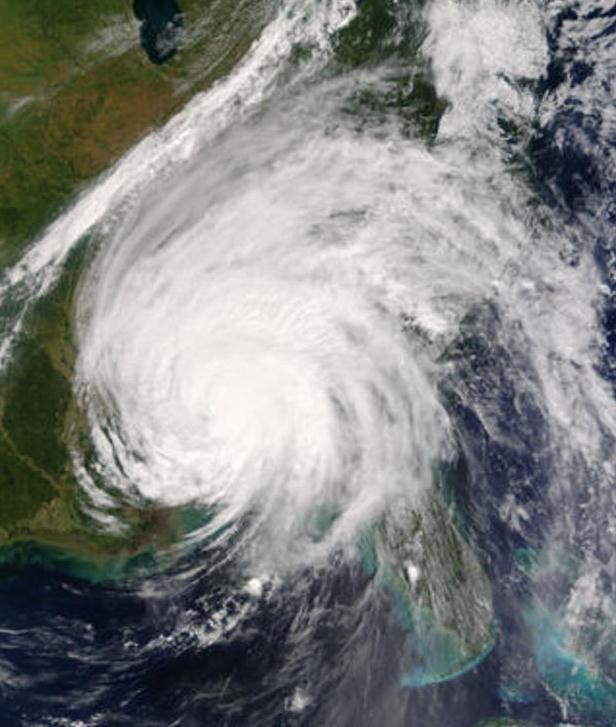
Hurricane Season Peaks, Guard Against Complacency. Hurricane season actually peaks September 10, the day hurricanes are most likely to strike the USA. Here’s an interesting nugget about tornado formation and fatalities triggered by tropical cyclones, courtesy of The Marine Corp Logistic Base in Albany, Georgia: “…Another hazard associated with tropical cyclones is straight-line winds and tornadoes. According to the National Hurricane Center, Hurricane Ivan in 2004 produced 127 tornadoes with 25 touching down in Georgia. Hurricane Beulah in 1967 spawned 115 tornadoes while Hurricane Frances in 2004 spawned 106 tornadoes. In 2005, Hurricane Katrina made landfall in Southeast Louisiana, 280 miles from Georgia, it spawned 20 tornadoes in the state, which is the highest recorded number in history for the month of August, according to the National Weather Service. The National Hurricane Center also reported about 10 percent of the tropical cyclone-related fatalities are caused by tornadoes…”
Image credit: Hurricane Ivan in 2004, courtesy of NASA.
Meghalaya: The Wettest Place on Earth. The Atlantic takes us to a place with perpetual monsoons. Somehow locals have found a way to adapt, even thrive. Here’s an excerpt: “Photographer Amos Chapple returns to our site once once again, bringing amazing images from the state of Meghalaya, India, reportedly the rainiest spot on Earth. The village of Mawsynram in Meghalaya receives 467 inches of rain per year. Laborers who work outdoors often wear full-body umbrellas made from bamboo and banana leaf. One of the most fascinating and beautiful features in the region are the “living bridges” spanning rain-soaked valleys. For centuries, locals have been training the roots of rubber trees to grow into natural bridges, far outlasting man-made wooden structures that rot in just a few years...” (Photo: Wikipedia).

What It Feels Like To Be The Last Generation To Remember Life Before The Internet. Are you old enough to remember a time before Netscape Mozilla’s crude web browser and AOL “You’ve Got Mail”? Me too. I miss those simpler days when people used rotary phones and there was a place where you could gather to talk to your friends. It was called a “bar”. That’s why this story at Quartz caught my eye; here’s a clip: “Technology has a lot to answer for: killing old businesses, destroying the middle class, Buzzfeed. Technology in the form of the internet is especially villainous, having been accused of everything from making us dumber (paywall) to aiding dictatorships. But Michael Harris, riffing on the observations of Melvin Kranzberg, argues that “technology is neither good nor evil. The most we can say about it is this: It has come...”
Photo credit above: “Michael Harris, the author of “The End of Absence.” Hudson Hayden.

What Does Depression Physically Feel Like? Here’s a snippet of a story from Huffington Post that caught my eye: “For people with depression, it can be a truly difficult task to explain their condition. Because it is a disease that is more commonly associated with mental symptoms — not outward, physical ones –those on the outside are often curious about what depression feels like. And it certainly feels like something: “In general, the worse the painful physical symptoms, the more severe the depression,” researchers wrote in an overview of depression and physical symptoms in the Journal of Clinical Psychology. “Symptoms have been found to increase the duration of depressed mood…”

The 25 Most Popular Mobile Apps in America. No games in the Top 25? I guess that’s progress. Or is it? Playing Tetris is probably safer than updating my Faceplant account; here’s an excerpt from Quartz: “In its latest mobile app report, comScore tracks the 25 most popular apps in the US. This is an interesting slice of the App Store, as it highlights active usage, not just one-time downloads or recent popularity…”
Graphic credit: Quartz and comScore.
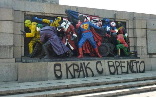
Russia Wants Bulgaria to Stop Vandalizing Sovient Monuments. It sounds like a bad joke, until you consider that maybe Russia is looking for another pretext to interfere in a former Soviet-block nation. Here’s a clip from The Moscow Times: “Russia is demanding that Bulgaria try harder to prevent vandalism of Soviet monuments, after yet another monument to Soviet troops in Sofia was spray-painted, ITAR-Tass reported. The Russian Embassy in Bulgaria has issued a note demanding that its former Soviet-era ally clean up the monument in Sofia’s Lozenets district, identify and punish those responsible, and take “exhaustive measures” to prevent similar attacks in the future, the news agency reported Monday…”
Photo credit above: Figures of Soviet soldiers at the base of a Soviet Army monument were previously transformed into superheroes in Sofia, Bulgaria.”


TODAY: Sizzling sun, high humidity. T-storms late. Dew point: 71 Winds: S 15. High: 91
SUNDAY NIGHT: More numerous T-storms, some heavy. Low: 63
MONDAY: Partly sunny, less humid. Dew point: 53. High: 80
TUESDAY: Cooler with showers likely. Wake-up: 61. High: 69
WEDNESDAY: Instant autumn. More showery rain. Wake-up: 58. High: near 70
THURSDAY: Showers, few T-storms. Wake-up: 60. High: 68
FRIDAY: Damp start, then peeks of sun. Wake-up: 61. High: 73
SATURDAY: Plenty of sun, milder. DP: 60. Wake-up: 60. High: 76
Climate Stories…
Climate Change and Implications for National Security. Here’s an excerpt of a story at International Policy Digest: “…Over the 250 years carbon fuels have enabled tremendous technological advances including a population growth from about 800 million then to 7.5 billion today and the consequent demand to extract even more carbon. This has occurred during a handful of generations, which is hardly noticeable on our imaginary one-year calendar. The release of this carbon – however – is changing our climate at such a rapid rate that it threatens our survival and presence on earth. It defies imagination that so much damage has been done in such a relatively short time. The implications of climate change are the single most significant threat to life on earth and, put simply, we are not doing enough to rectify the damage…”
Photo credit above: Department of Defense photo. “If you wait until you have 100 percent certainty, something bad is going to happen…” – General Gordon R. Sullivan, Retired, former U.S. Army Chief of Staff.

Kansas’ Climate Change Debate Settled in Europe. While Americans debate the science much of Europe is moving forward with plans to scale back the use of fossil fuels. What’s missing here? Environmentally-minded Americans who care about this issue have yet to band together and exert political pressure. That will change in the years ahead (with our kids and grandkids out in front). Here’s an excerpt from CJOnline.com: “…One of the key differences, King said, is the influence of Green parties within European nations. To get action on climate change, he said, environmentally-minded Americans must increase their influence in the political sphere. In Germany, the Greens hold about 10 percent of the seats in a 631-member parliament made up of five parties. Oliver Krischer, vice chairman of the German Green Party’s parliamentary group, said he hasn’t heard members of other parties say they believe human-caused climate change is a myth. “There might be some colleagues in the Bundestag that think so,” Krischer said. “You cannot look in their heads. But there is at least nobody that says climate change is an invention of some scientists...”
Photo credit above: Andy Marso, The Capital-Journal. “Jon Möller, a researcher with the Stockholm city government’s climate and energy division, shows a map that includes the city’s Royal Seaport, which citizens intend to make free of fossil fuels by 2030.”

Portraits of Scared Scientists Seek to Drive Home the Critical State of Climate Change. The most frightening thing about climate change is that we continue to ignore it. Here’s a clip from a story at PetaPixel: “Photographer Nick Bowers, Art Director Celine Faledam and Copy Writer Rachel Guest have teamed up to bring attention to the issue of climate change in a completely novel and frankly terrifying way with their portrait/interview project Scared Scientists. The title, in a way, says it all. Rather than bombarding you with obscure facts and figures or showing you photographs of receding glaciers, they focus on the scientists themselves...”
Dangerous Climate Change: Myths and Reality. Predicting the future is tenuous. Are we underestimating or overestimating the impacts of AGW? One thing is certain: the last time there was this much carbon, methane and other greenhouse gases floating overhead humans weren’t on the planet. Here’s an excerpt of an article at Climate Code Red focused on the myth (?) that climate change is “not yet dangerous”: “…From this perspective, tipping points have already been passed, at less than 1°C of warming, for:
- The loss of the Amundsen Sea West Antarctic glaciers, and 1–4 metres of sea level rise (Rignot, Mouginot et al., 2014; Joughin, Smith et al., 2014). Dr Malte Meinshausen, advisor to the German government and one of the architects of the IPCC’s Representative Concentration Pathways, calls the evidence published this year of “unstoppable” (Rignot, 2014) deglaciation in West Antarctica “a game changer”, and a “tipping point that none of us thought would pass so quickly”, noting now we are “committed already to a change in coastlines that is unprecedented for us humans” (Breakthrough, 2014).
- The loss of Arctic sea-ice in summer (Duarte, Lenton et al., 2012; Maslowski, Kinney et al., 2012), which will hasten regional warming, the mobilization of frozen carbon stores, and the deglaciation of Greenland...”
Photo credit above: Jenna Dorsey.
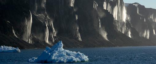
World’s Largest Ice Sheets Melting At Fastest Rate Ever Recorded. Huffington Post confirms what climate scientists have known for some time: the melting is happening even faster than most climate models predicted. Here’s a clip from Huffington Post: “…Using the European Space Agency’s CryoSat 2 satellite, the Alfred Wegener Institute from Germany has found that western Antarctica and Greenland are losing massive amounts of ice. “Combined, the two ice sheets are thinning at a rate of 500 cubic kilometres per year,” said glaciologist Dr. Angelika Humbert, one of the authors of the AWI study, in a press release. “That is the highest speed observed since altimetry satellite records began about 20 years ago…”
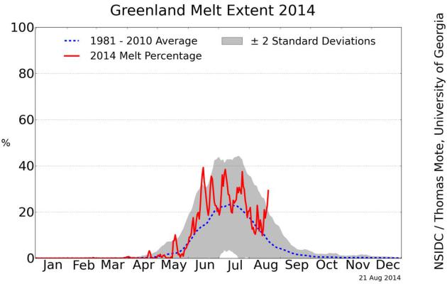
Greenland Ice Melt: 2014. Here’s an excerpt of an update on the extent of ice melt in Greenland (more than 2 standard deviations for much of June and July) from the National Snow and Ice Data Center: “Melting on the surface of the Greenland Ice Sheet in June and July 2014 has been well above the 1981 to 2010 average in most areas, but after a fast start in May, the southern region and the southeastern coast have seen lower-than-average melt. Mid-summer surface melting did not reach higher elevations (above 2000 meters) as often as in the reference period 1981 to 2010. Short bursts of extensive melting were related to periods of high air pressure over the ice sheet favoring sunny conditions, and promoting increased melting in darker areas of the ice sheet (wet snow, bare ice, or dirty snow)...”
