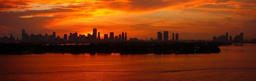
Blah March? Winter Storm Watch for Slushy Snow Friday Night & Saturday AM
Look at the bright side: you won’t need to wear bug repellent anytime soon. No need to mow the lawn or dirty up your knees with aerobic weeding. Severe thunderstorms will not muck up your outdoor plans anytime soon. No lounging by the lake, so I don’t have to cut my caloric intake and go on a hunger strike to fit into my swim trunks. Great news, right?
In reality the average high now is in the mid-40s, and we won’t be too far off the mark in the coming days. March is running about 1F milder than average, to date; a sun angle similar to mid-September will lower the risk of arctic blasts into April.
Many towns from Philly to New York are digging out from a foot or more of snow, while Minnesota enjoys some blue sky and mid-40s today. Rain late Friday changes to wet snow Friday night and a few inches may accumulate before it tapers off by midday Saturday. Plowable? It’s quite possible, especially south and west of the Twin Cities Friday night. The joys of March.
Weather systems are slowing down again; models hint at (rain) showers from Monday into Thursday of next week with nighttime lows generally above 32F.
Our slow meltdown continues, and I’d think twice before testing the ice on area lakes.
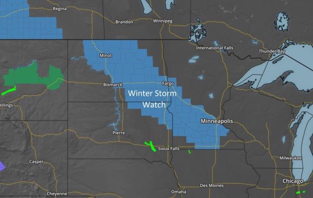
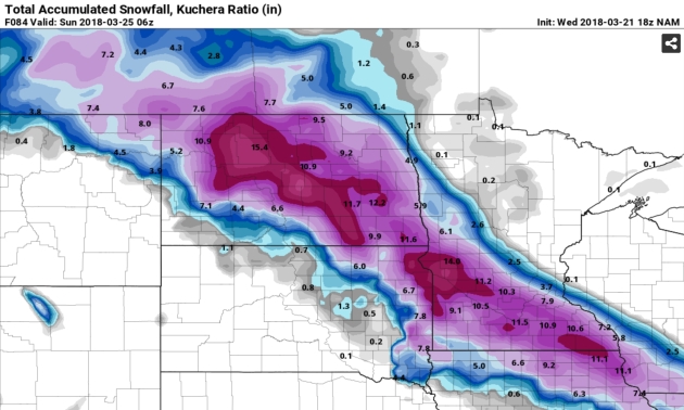
Winter Storm Watch. Not much of a shock in March, an authentic Tournament Storm may be shaping up for late Friday into Saturday; starting as rain Friday PM, but changing over to wet snow Friday night before tapering off Saturday morning. Enough to shovel, scrape and plow? It’s early to be throwing out potential amounts, but it may be enough to gum up travel plans, especially south/west of MSP Friday night. Map: AerisWeather.
Spaghetti Plot. Models show anywhere from 1-4″ of slushy snow Friday night, but it’s early with this system – and the forecast for snow amounts will change. I expect a huge gradient between Hugo and Blaine (very little accumulation) to Shakopee, Chaska and Glencoe, where amounts may be more significant. Plot: Iowa State IEM.
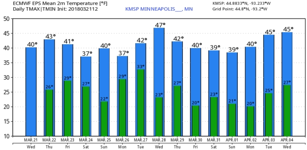
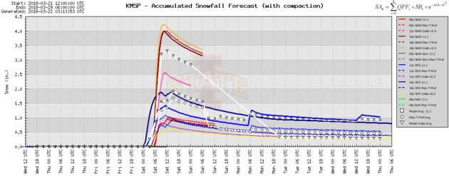
ECMWF Guidance. Whatever snow does fall Friday night and early Saturday will probably melt within 48 hours; the sun angle too high for (new) snow to linger for long. No serious warm fronts brewing, but expect more 40s than 30s over the next 1-2 weeks. Twin Cities numbers: WeatherBell.
Praedictix Briefing: Issued Wednesday, March 21st, 2018:
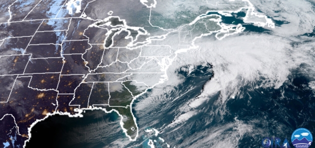
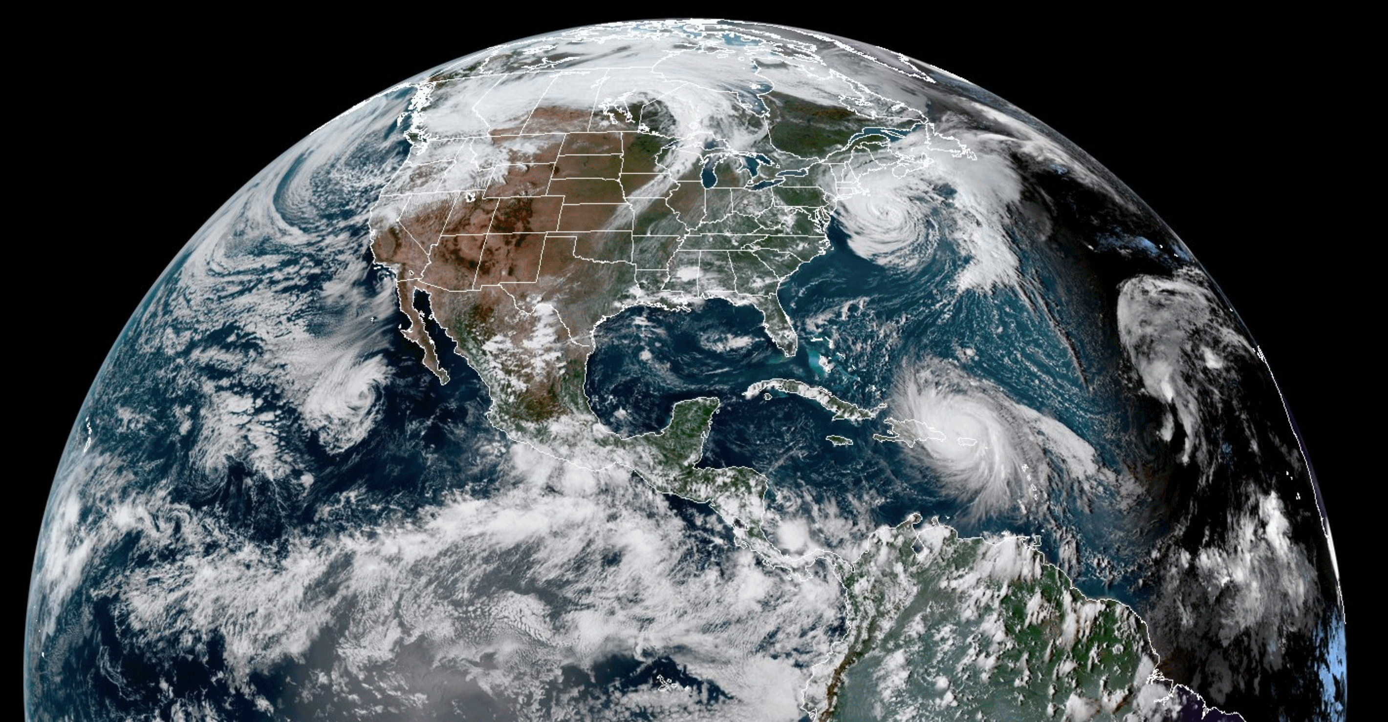
- Heavy snow is already falling across parts of the Northeast this morning with the fourth coastal storm to impact the region in the past three weeks.
- Snow will continue to fall today – heavily at times – along I-95 from Washington D.C. to Boston. Totals are expected to be the heaviest in the Philadelphia and New York City areas, where totals of 11-18” are possible by the time snow ends tonight.
- Minor to moderate coastal flooding can be expected at high tide through Thursday.
- Strong winds are also expected during this system, especially near the coast. High Wind Warnings and Wind Advisories are in effect for coastal Massachusetts and Rhode Island for wind gusts between 40-60 mph.
- The combination of heavy snow and strong winds will create significant impacts across the region, including power outages and tree/property damage, as well as difficult to impossible travel conditions.
- We’re also tracking heavy rain across California through Thursday. Parts of southern California are under a Flash Flood Watch due to the potential of flash flooding and mudslides in burn scar areas.

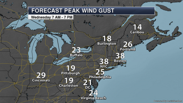
Winter Weather Concerns. Numerous Winter Storm Warnings and Winter Weather Advisories are in effect from the Ohio Valley and Appalachian Mountains into New England in association with this system. The heaviest snow will fall where Winter Storm Warnings are in effect, with snowfall totals of at least 5-6” expected. In some of these warning areas, snowfall totals could end up being over a foot by the time the snow ends. Here’s a breakdown of alerts in place for some of the larger cities in the Northeast this morning:
- Washington D.C. and Baltimore are under a Winter Storm Warning until 8 PM tonight. Total snow accumulations of 4-8” are possible.
- Philadelphia is under a Winter Storm Warning until 2 AM Thursday. Additional snow accumulations of 9-13” are expected.
- New York City is under a Winter Storm Warning until 6 AM Thursday. Total snow accumulations of 12-18” are expected.
- Boston is under a Winter Storm Warning until 8 AM Thursday. Total snow accumulations of 5-9” are expected.

Expected Snowfall. Snow totals of at least 6” are expected from Philadelphia to parts of southern New England with this system. The heaviest snow totals across the region are expected from just north of Philadelphia to parts of Long Island and southern Connecticut (including New York City). In these areas, snow totals of 12-16″ are likely. Substantial impacts to the region are possible, especially in areas where totals approach/exceed a foot. Difficult to impossible travel conditions can be expected across the region today into at least early Thursday, with reduced visibilities and snow covered roads. Power outages and tree damage is also likely due to the strong winds and heavy snow. Map: AerisWeather and Praedictix.
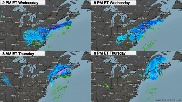
Timing The Precipitation. Snow will continue to spread across parts of the Northeast today, with heavy snow likely along the I-95 corridor from D.C. to New York City. Snow will finally start to end across these areas as we head into the overnight hours. Snow won’t start in Boston until the afternoon hours with the heaviest snow falling tonight before tapering off Thursday (and even potentially changing over to rain showers). Snow will continue across portions of northern New England Thursday.
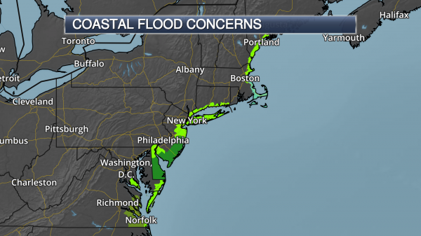
Coastal Flood Concerns. We are not only monitoring the snow potential with this system but also the threat of coastal flooding. Inundations of 1-4 feet are possible at high tide into Thursday across the region, which will cause flooding of roads and low lying property near the coast.

Minor To Moderate Coastal Flooding. A wide area of minor to moderate flooding is possible at high tide through the middle of the week at coastal flood gauges, as is shown here in this graphic from NOAA and the USGS.
Gusty Winds Expected. Strong gusty winds are also expected with this coastal low today into tonight, with wind gusts topping 20-30 mph for areas from Philadelphia to Boston. The strongest gusts with this system will be near the coast. Power outages and downed trees will be possible, especially with the heavy snow.

Wind Advisories And Warnings. Due to the potential of strong winds across parts of coastal New England, High Wind Warnings and Wind Advisories have been issued. The High Wind Warnings are in effect through Thursday morning for Block Island as well as Cape Cod and the islands due to wind gusts between 50-60 mph. Wind Advisories are in effect for the greater Boston area as well as coastal Rhode Island and Massachusetts until 8 AM Thursday morning for sustained 20-30 mph winds with gusts up to 50 mph. These winds would have the potential to cause damage to trees, powerlines and property in the region.

California Morning Radar. Heavy rain is already falling across portions of California this morning as moisture streams into the region. Over an inch of rain has been reported since midnight in Emigrant Gap and Grass Valley.
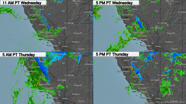
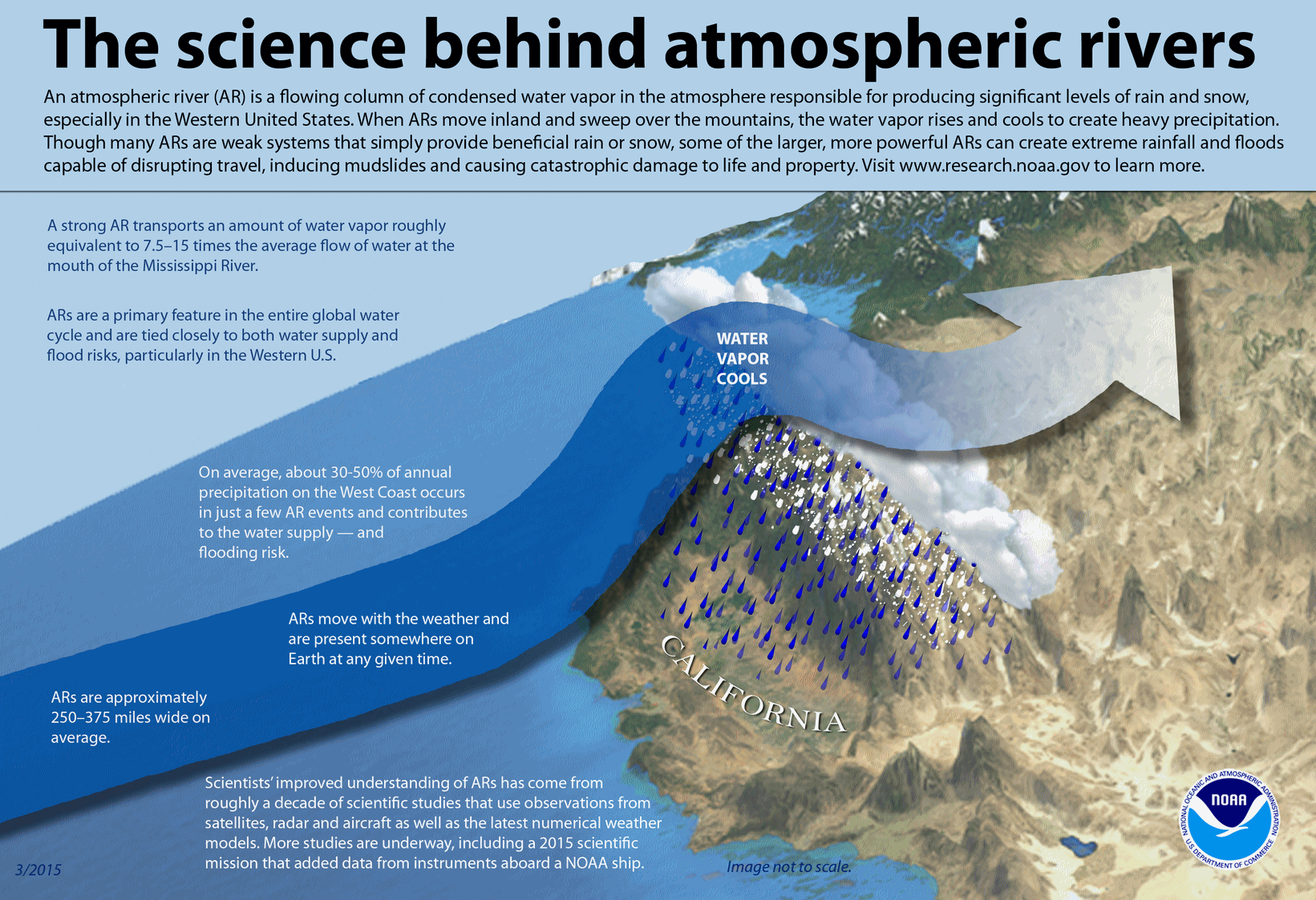
Tracking Heavy California Rain. An atmospheric river event is setting up across California, especially in southern portions of the state, through Thursday. Moderate to heavy rain is expected across the region today into Thursday before the precipitation finally starts to taper off. Some of the heaviest precipitation for the Los Angeles area is expected late tonight into early Thursday afternoon.
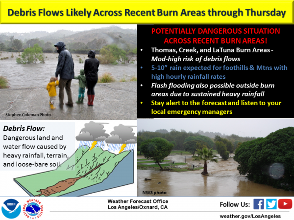
Burn Scar Concerns. This heavy rain event will impact recent burn scar areas across southern California, including around the Thomas Fire burn scar. The potential exists for 5-10” of rain in the foothills and mountains over the next 24-36 hours, which would lead to the potential of mud slides and debris flows. Other rain events so far this winter have already caused mud slides in some of these burn scars, so we can expect the same this time around. (Graphic: National Weather Service Los Angeles).
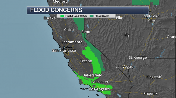
Flash Flood Watches. Flash Flood Watches continue in the Los Angeles area across recent burn scar areas. Heavy rain though Thursday, especially across burn scars in the counties of San Luis Obispo, Santa Barbara, Ventura and Los Angeles, could produce dangerous flooding, mud slides, and debris flows. Across these counties, Flash Flood Watches still have the potential to be extended to include non-burn scar areas. Further south, including Orange County and the Inland Empire, Flash Flood Watches are in effect for the heavy rain potential that could lead to urban flooding. Across central California, these watches are in effect for heavy rain and additional snow melt which could cause flash flooding as well as debris flows (mainly in burn scar areas).
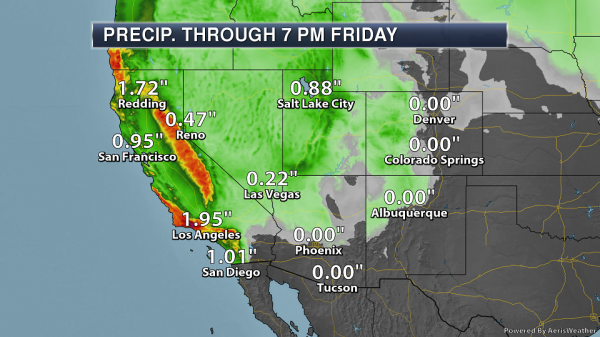
Expected California Rain. Rainfall amounts of a half an inch to three-quarters of an inch per hour are possible, especially during the heaviest period of rain from later today into Thursday. This long-duration rain event will bring the potential of up to 2-6” of rain for coastal and valley areas, with up to 10” of rain in the foothills and mountains in the Los Angeles area (especially on south facing slopes). With this amount of rain expected across the region, flash flooding and debris flows – especially in recent burn scar areas – are likely.

Expected Rain Around Los Angeles. As we take a closer look at the Los Angeles areas, we expect a widespread 1-4”+ of rain over the next couple days. Some of the heaviest rain for Los Angeles is expected to fall Thursday.
Summary. Heavy snow will continue to fall across parts of the Northeast today, with snow totals of 11-18” possible from Philadelphia to New York City. This heavy snow, along with gusty winds, will produce low visibilities and the potential of power outages and tree/property damage. Travel across the region will be difficult if not impossible throughout the day. Some minor to moderate coastal flooding is also expected at high tide through Thursday. Heavy rain is moving into California today, with the potential of up to 10” of rain in southern parts of the state through Thursday. Flash flooding and mud slides/debris flows, especially in recent burn scar areas, are possible.
D.J. Kayser, Meteorologist, Praedictix
Sirens, Alerts and Helmets: A Realistic Look at Tornado Warnings and Survival. WIBC.com shares an interview with Alabama weather legend James Spann. Here’s an excerpt that caught my eye (that I happen to agree with): “…Spann spoke emphatically about what he considers an antiquated warning system that many people believe is a definitive source for tornado warnings – sirens. “This is a product of WWI. What year is this? Last time I checked this is like 2018 and why is it most people to this day connsider this to be their primary source of tornado warning information? asked Spann. Sirens are operated by emergency managers, generally, and are not controlled by the National Weather Service. “They’re something you can never hear in a house, in a school or a business or a church.…”
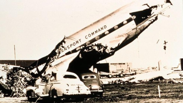
Why 2 Tornadoes 70 Years Ago This Week Are the Most Important in U.S. History. The Weather Channel explains: “…Before then, public tornado alerts were banned for fear of causing unneeded panic. When analyzing surface and upper-air data from other outbreaks, Fawbush and Miller noticed large-scale weather patterns common to each event. A few days later, on the morning of March 25, the pair noticed that a similar weather pattern was setting up that day and concluded that a tornado threat existed again in central Oklahoma that afternoon. Then it was a question of confidence. After consulting Fred Borum, commanding general of the Oklahoma City Air Material Area, a forecast for “heavy thunderstorms between 5 and 6 p.m.” was issued for the base. “You are about to set a precedent,” Gen. Borum told the men...”
File photo credit: “A large airplane destroyed by the second Tinker Air Force Base tornado on March 25, 1948, just five days after the first. This tornado was preceded by the first tornado warning ever issued.” (NOAA Photo Library)
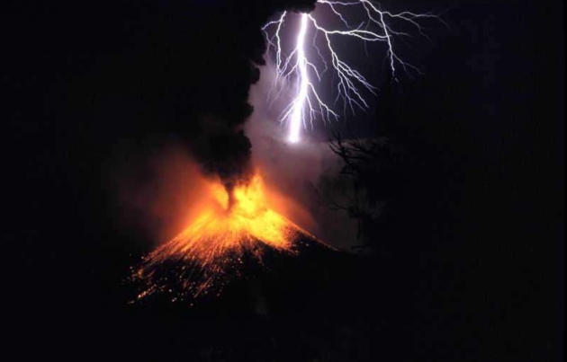
Six Freaky and Terrifying Kinds of Severe Weather. MSN.com has an interesting post, including news of volcanic lightning: “…Contrary to what you might imagine, the incandescent shot below is not part of a Swedish Viking metal album, although we would forgive you if that was your original assumption. It was shot by photographer Oliver Spaltin 1995, at a safe distance from Indonesia’s Mt. Rinjani, one of the archipelago nation’s many, many volcanoes. Volcanic eruptions are catastrophic and awe-inspiring enough, so the addition of a few bolts of lightning kind of seems like overkill, but they do happen, although the process that creates them is not 100 per cent understood. They could be a by-product of what meteorologists call ‘dirty thunderstorms.’…”
Photo credit: The Weather Network: News.
Losing Access to Weather Data Means the Next Storm Could Be a Lot More Deadly. Careful with the spectrum that may be auctioned – losing it may have unintended and potentially tragic consequences. Here’s an excerpt of an Op-Ed at TheHill: “…Nestled in the FCC’s budget proposal for fiscal years 2018 and 2019 is a plan to auction a portion of spectrum, between 1675 and 1680 MHz, which is currently allocated for weather satellites. An auction would void the government’s exclusive use of the frequencies, requiring sharing and causing interference with a mobile network operating on stronger signals. Currently, data from GOES-R is delivered to users almost instantly, because seconds matter when dealing with hazardous weather. The advanced imagers on GOES-R and GOES-S can capture evolving storms up to every 30 seconds. This succession of images is critical because volcanoes can erupt, tornadoes can form, and wildfires can spread in an instant…”
Big Improvement in Predicting Drought-Busting Atmospheric Rivers. A story at Water Deeply caught my eye; here’s a snippet: “…New research in the last few years has uncovered some of the mystery behind atmospheric river storms, helping to predict storm timing and intensity. Now a new study by scientists at Colorado State University in Fort Collins has revealed a way to predict atmospheric river storms as much as five weeks in advance. That’s well beyond what current tools allow, and it could provide enough lead time to make important decisions about water management. The method describes a new way to interpret two other large-scale weather phenomena – the Madden-Julian oscillation (MJO) and quasi-biennial oscillation (QBO) – as a signal for atmospheric river events...”

Bomb Cyclones, Nor’easters, and the Messy Relationship Between Weather and Climate. Amen to that. The New Yorker attempts (and succeeds) in connecting the dots; here’s an excerpt: “…Francis had already noted, in 2009, that the jet stream was weakening, especially after summers when Arctic sea ice was at record lows. She proposed that Arctic warming was the culprit, positing that higher temperatures decreased the pressure gradient between the North Pole and the midlatitudes, sapping the jet stream of its energy. Building on that research, Francis and Vavrus found that, in the previous three decades, as the Arctic heated up, the jet stream’s amplitude—the distance it strayed north and south in its journey around the globe—had grown in the fall and winter by about ninety miles. This increased waviness, they suggested, meant that the eastward progression of weather patterns embedded in the jet stream could also be slowing down, causing, among other things, frigid blobs of polar air to linger over the East Coast and heat spells to persist in the West….”
* Click here to see a YouTube interview with Dr. Jennifer Francis, examining the possible link between rapid arctic warming and changes in the configuration of the jet stream over time.
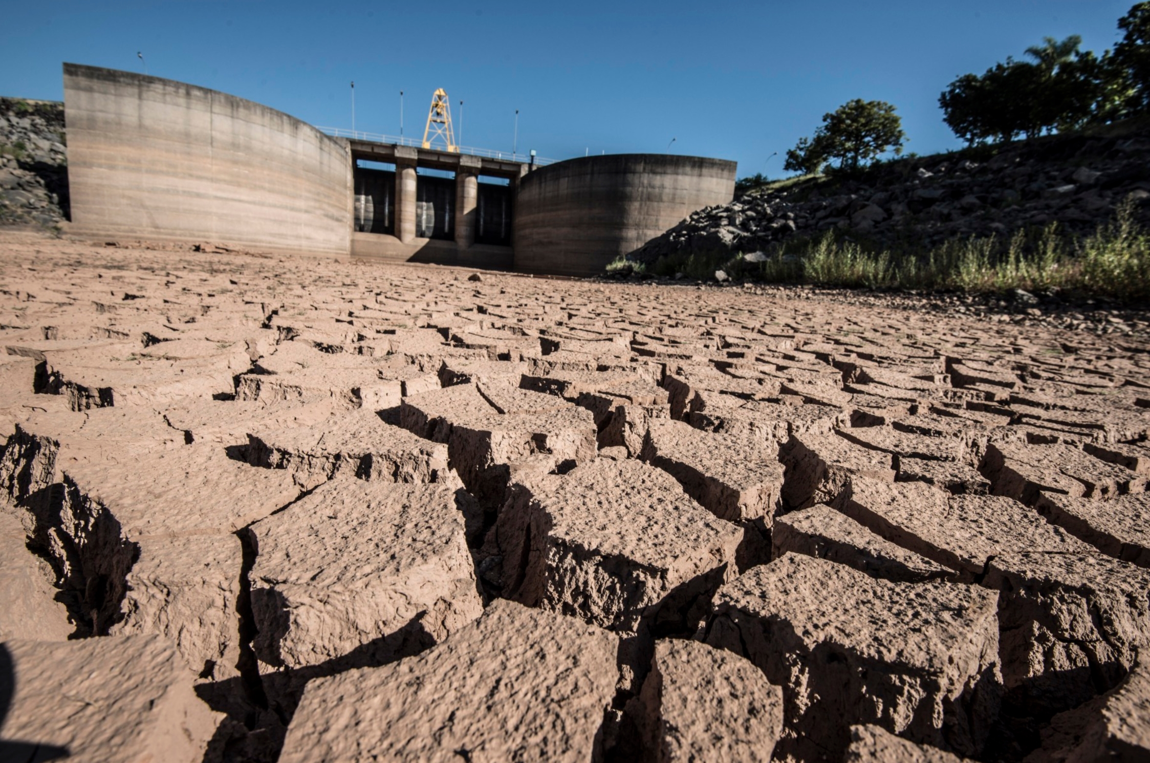
Taps Run Dry in Water Summit City in World’s Wettest Nation. Bloomberg reports: “Delegates to the World Water Forum that kicked off in Brasilia on Monday are unlikely to suffer from water shortages during their stay, unlike many of the city’s residents who’ve endured rationing for up to 2 days a week for over a year. And the rationing isn’t restricted to the nation’s capital. Last year at least a quarter of Brazilian municipalities faced water shortages. Even in Belem, a city nestled on the greater Amazon river system, water service is frequently interrupted, due in part to poor infrastructure. Brazil has the largest fresh water reserves in the world, including the massive underground Guarani aquifer it shares with Paraguay and Argentina. Yet a combination of droughts, population growth, and mismanagement have drained water reservoirs more frequently in recent years. In Sao Paulo in 2014 those reservoirs dwindled to little more than pools of mud. Brazil’s situation, which mirrors crises such as that in Cape Town only on a much bigger scale, is a warning to other countries that putting off water resource management means a massive bill down the line…”
Photo credit: “Jaguari Dam in Sao Paulo in 2014.” Photographer: Paulo Fridman/Bloomberg.

Weather Behind Headaches, Sufferers Say. Weather may be just one of multiple factors that affect the onset and intensity of migraines, according to a story at MedicineNet.com: “...About 28 million Americans suffer from migraine headaches, with 25% of women and 8% of men experiencing one or more migraines over the course of a lifetime. In the survey of nearly 200 frequent headache sufferers, about one out of three reported limited travel because of headaches. Seventy-four percent said their ability to participate in outdoor activities had been restricted because of changes in weather, altitude, high winds, or bright lights. Atlanta-based neurologist Leslie Kelman, MD, tells WebMD that it is not clear how weather changes might trigger headaches, but some research suggests that they do. In one study reported in 2004, researchers compared headache calendars kept by patients who believed weather played a major role in their headaches to weather data from the National Weather Service…”

A Super-Sized Allergy Season? CBS News reports on new research showing that a longer growing season is leaving more Americans sneezing and wheezing: “…According to the Centers for Disease Control and Prevention, more than 50 million Americans suffer from allergies each year. While allergies are more common in children, they can occur for the first time at any age. With allergy seasons growing longer and more intense, experts say many people are developing seasonal allergies for the first time well into their adulthood. Shapiro said many of his patients’ symptoms are more severe than in the past, and he expects the trend to continue, as well…”
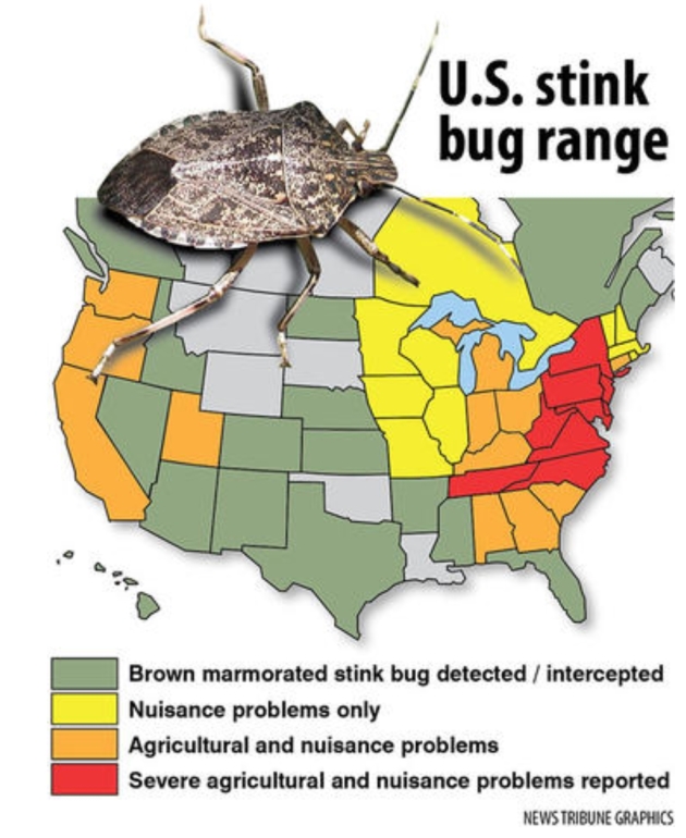
This Next Insect Invasion Is Going to Stink. Duluth News Tribune gives us all something to look forward to: “Asian lady beetles congregate en masse in our homes each autumn. Emerald ash borers are eating their way across neighborhoods and forests. Gypsy moths are munching across the state from east to west on their way across North America. But beware, Minnesota, you haven’t smelled anything yet. Roll out the welcome mat for the next alien invader from afar, another unwelcome guest that arrived from Asia in packaging, probably in about 1996 near Allentown, Penn., and has been expanding across the continent ever since. Meet the brown marmorated stink bug, a creature so foul that it will eat its way across fields of farm crops, orchards, gardens and vineyards and then congregate by the hundreds in your home to spend the winter…”

Golden Arches Go Green: From Climate Nexus: “McDonald’s will aim to cut its greenhouse gas emissions at its restaurants and offices by one-third by 2030, the fast food giant announced Tuesday. The company also pledged to work to cut 31 percent of emissions from its supply chain, saying it would “prioritize action” on reducing emissions from beef production. The company’s plan includes working with franchises and suppliers to install energy-efficient kitchen equipment and LED lights, promoting sustainable packaging and supporting sustainable beef grazing and agricultural practices.” (Bloomberg, Reuters, USA Today, Fast Company, Fortune)

New IBM Report Predicts 5 New Technologies That Will Change the World in the Next 5 Years. Here’s a clip from a story at BGR.com: “…AI-powered robot microscopes — networked in the cloud and deployed worldwide — will be robust enough to monitor in real time the health of water sources like oceans around the globe. Though artificial intelligence systems are only as good as the data they’re trained on, we’ll see an explosion in “biased” AI. Quantum computing is going mainstream. In five years’ time, it will be a critical piece, for example, of a computer engineering degree. It will move beyond the research lab and new categories of professionals, developers and students will emerge. So-called lattice cryptography will be used to fight cyberattackers. That cryptography method, according to IBM, is built on an underlying architecture “that hides data inside complex algebraic structures called lattices…”
File image credit: Future of Life Institute.
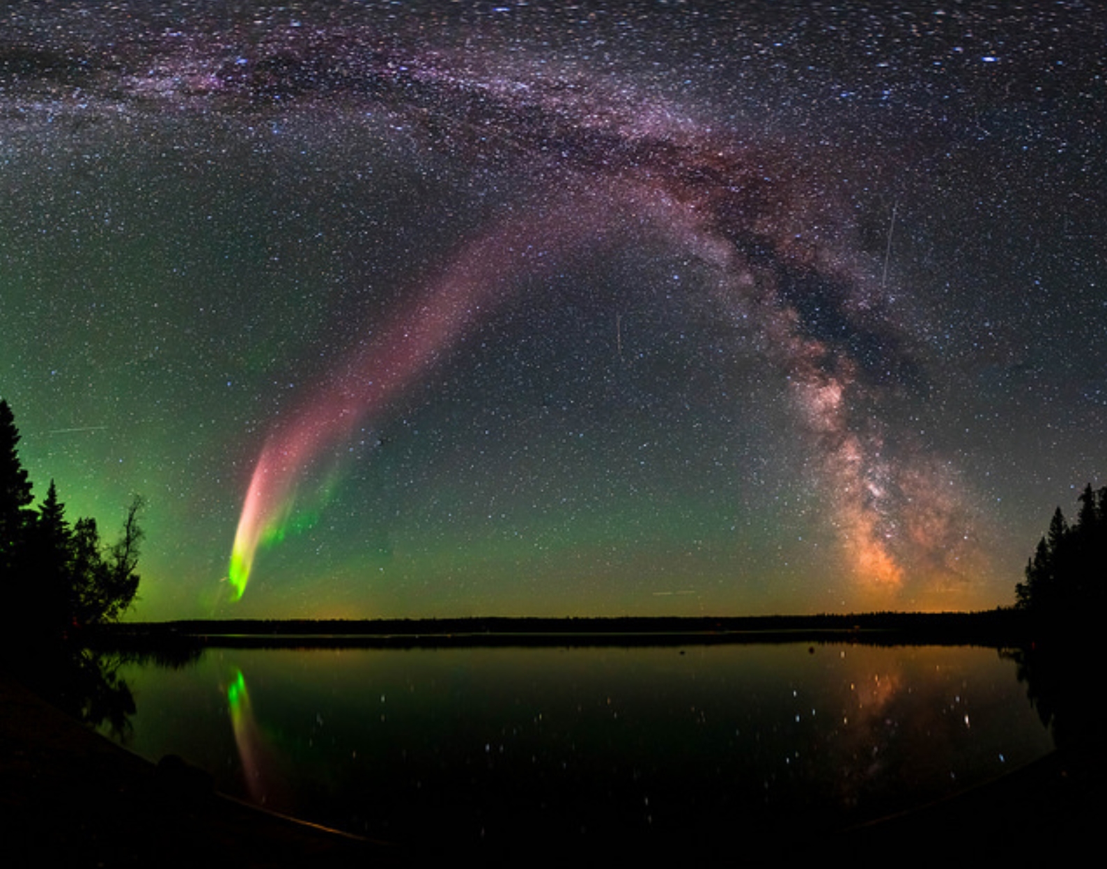
What’s Up With “Steve”? A New Kind of Aurora Demystifed by Scientists. Aurora-chasing? Who knew? Here’s an excerpt of a very good explainer at ZME Science: “…A band of dedicated Canadian aurora chasers was among the first who took pictures of Steve. The aurora feature was first posted on the Facebook group Alberta Aurora Chasers in 2016 and, initially, most thought they were looking at a ‘proton arc’ — another rare type of aurora, which isn’t caused by electrons hitting Earth’s magnetic field but by more massive protons following a solar flare. Eric Donovan from the University of Calgary was one of the first scientists who probed Steve, a 25 to 30 kilometer (15 to 18 miles) wide arc that aligns east-west and can extend over hundreds of miles. He recognized that this wasn’t a proton arc for a number of reasons, including the fact that a proton aurora is hardly visible...”
Photo credit: NASA Goddard Space Flight Center.
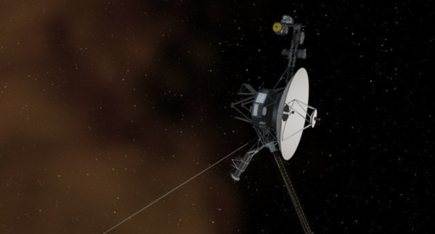
NASA Gets Response from Spacecraft 13 Billion Years Away. Pretty amazing, when you think about the distances involved. Science Vibe has details: “NASA has just received a response from the void, and believers everywhere are losing their collective minds. After 37 years of inactivity, the NASA spacecraft Voyager 1 fired up its thrusters for the first time in nearly four decades all the way over in interstellar space. This incredible – and unsuspected – triumph means Voyager 1 can once again communicate with Earth, from 13 billion miles away. Voyager 1, NASA’s farthest and fastest spacecraft, is the only human-made object in interstellar space, the environment between the stars...”
38 F. high temperature in the Twin Cities on Wednesday.
44 F. average high on March 21.
40 F. high on March 21, 2017.
March 22, 1991: A historic ice storm begins during the afternoon and ends as heavy, wet snow on the 23rd. This event coated the city of Duluth with as much as 6 inches of ice. The 850-foot WDIO-TV tower was toppled. 4 million pine trees were damaged or destroyed with the heaviest damage at G.C. Andrews State Forest near Moose Lake in Pine County.
March 22, 1952: A snowstorm dumps 13.2 inches on the Twin Cities.
THURSDAY: Peeks of sunshine. Winds: E 5-10. High: 46
THURSDAY NIGHT: Partly cloudy. Low: 30
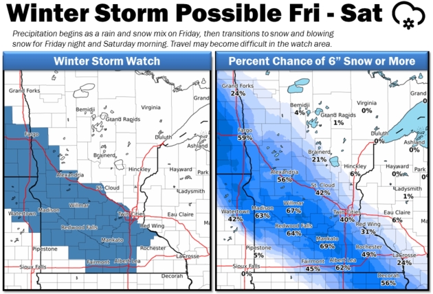
FRIDAY: Winter Storm Watch. Clouds increase, rain arrives – changing to snow Friday night. Winds: SE 10-20. High: 43
SATURDAY: Winter Storm Watch. Few inches AM hours, PM clearing. Winds: E 8-13. Wake-up: 32. High: 40
SUNDAY: Mostly cloudy, a drier day. Winds: SE 7-12. Wake-up: 29. High: 48
MONDAY: Few spring (rain) showers. Winds: SE 7-12. Wake-up: 32. High: 44
TUESDAY: Mostly cloudy, drying out a little. Winds: N 5-10. Wake-up: 33. High: 45
WEDNESDAY: Cool and unsettled, few showers. Winds: NW 7-12. Wake-up: 32. High: 43
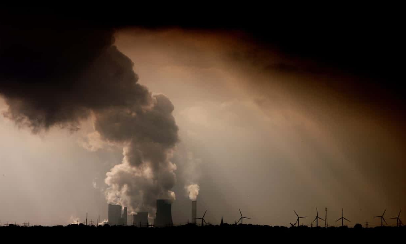
Climate Stories…
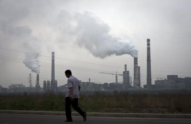
Tougher Climate Policies Could Save 150 Million Lives, Researchers Find. The Washington Post explains: “There is an overlooked benefit to greatly lowering carbon emissions worldwide, a new study says. In addition to preserving Arctic sea ice, reducing sea-level rise and alleviating other effects of global warming, it would probably save more than 150 million human lives. According to the study, premature deaths would fall on nearly every continent if the world’s governments agree to cut emissions of carbon and other harmful gases enough to limit global temperature rise to less than 3 degrees Fahrenheit by the end of the century. That is about a degree lower than the target set by the Paris climate agreement. The benefit would be felt mostly in Asian countries with dirty air — 13 million lives would be saved in large cities in India alone, including the metropolitan areas of Kolkata, Delhi, Patna and Kanpur…”
File photo: Andy Wong, AP.
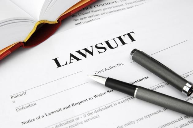
LAWSUITS: Headlines and links from Climate Nexus: “The judge in a federal climate change lawsuit wants a science tutorial (Vox), on trial for causing climate change, oil companies don’t plan to deny it’s happening (Sacramento Bee), Chevron says climate change lawsuit `not viable’ as it prepares to educate judge on science (Forbes), a judge asks basic questions about climate change–we answer them (The Guardian), climate denial arguments make way to science tutorial by federal judge.” (Climate Liability News).
Should Oil Companies Pay for Climate Change? Yes, There is Evidence. San Francisco Chronicle has the story: “On Wednesday, a federal judge will hold a “climate science tutorial” as part of San Francisco’s and Oakland’s nuisance cases against five oil giants for damages related to sea level rise. He has invited plaintiffs and defendants to present the history of climate science and “the best science now available on global warming, glacier melt, sea rise and coastal flooding.” Last week another federal court rejected oil companies’ efforts to get nuisance cases filed against them by Imperial Beach (San Diego County) and Marin and San Mateo counties moved from state courts into the federal system. The decision dealt the companies a huge blow, given favorable California law. At the heart of both cases are these central questions: What did fossil fuel producers know about climate change and its causes and effects, when did they know it, and how did their public statements square with what they knew? The answers could help determine whether these companies should pay for some of the billions of dollars needed to protect Californians from rising seas and damage from drought, wildfire and other extreme events worsened by climate change…”
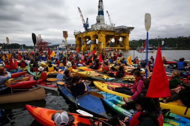
Photo credit: DANIELLA BECCARIA, SEATTLEPI.COM. “People in kayaks protest against the Port of Seattle being used as a port for Shell Oil’s Arctic drilling rig Polar Pioneer in May 2015.”
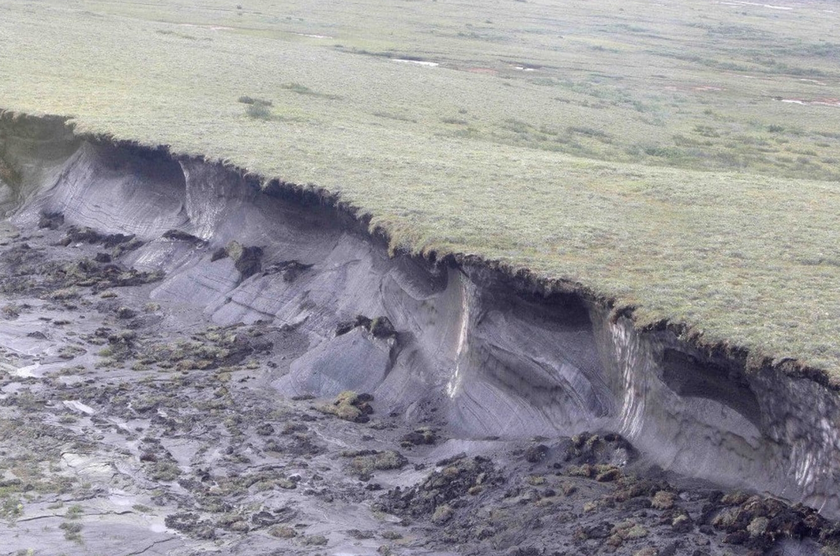
The Arctic’s Carbon Bomb Might Be Even More Potent Than We Thought. Chris Mooney reports for The Washington Post; here’s an excerpt: “For some time, scientists fearing the mass release of greenhouse gases from the carbon-rich, frozen soils of the Arctic have had at least one morsel of good news in their forecasts: They predicted most of the gas released would be carbon dioxide, which, though a greenhouse gas, drives warming more slowly than some other gases. Scientists obviously weren’t excited about more carbon dioxide emissions, but it was better than the alternative: methane, a shorter-lived but far harder-hitting gas that could cause faster bursts of warming. Now even that silver lining is in doubt. Research released Monday suggests that methane releases could be considerably more prevalent as Arctic permafrost thaws. The research finds that in waterlogged wetland soils, where oxygen is not prevalent, tiny microorganisms will produce a considerable volume of methane, a gas that doesn’t last in the air much more than a decade but has a warming effect many times that of carbon dioxide over a period of 100 years…”
Photo credit: “In this 2009 photo, a hill of permafrost “slumps” from global warming near the remote, boggy fringe of North America in Canada’s Northwest Territories, 1,400 miles from the North Pole.” (Rick Bowmer/AP).
The Future May Hold Twice as Many Heat Waves. Miami Herald has a summary of new research: “…In 1995, a heat wave killed more than 1,000 people in Chicago. In 2010, more than 55,000 died when a heat wave sparked devastating wildfires in Russia. New research led by scientists at the University of Miami Rosenstiel School of Marine and Atmospheric Science and NOAA shows that the future holds more heat waves in the U.S., thanks to human-caused climate change. Without humans and their fossil-fuel-burning habits, the future would hold half as many heat waves, the research shows. And certain parts of the country could start seeing heat waves largely caused by human climate change as soon as 2027…”
File image: Climate Nexus.
.jpg)
A New Era of Extreme Heat Waves May Be Just a Few Years Away. With more perspective on the research referenced above here’s an excerpt from a story at Forbes: “…The research used climate models to look at four U.S. regions and assess when we can likely say that climate change will become the leading driver of heat waves over the natural variability of the climate. In other words, when we will be able to say “humans caused this heat wave” and have a better than fifty percent chance of that being an accurate statement. For much of California, Nevada and the arid parts of Oregon, Utah, Arizona and Idaho, that will be the case in just a few years, according to the study. The same could be true for the Great Lakes region in the 2030s, while the Great Plains have 30-50 years before they’re hit as hard with human-caused heat…”
Image credit: AFP.
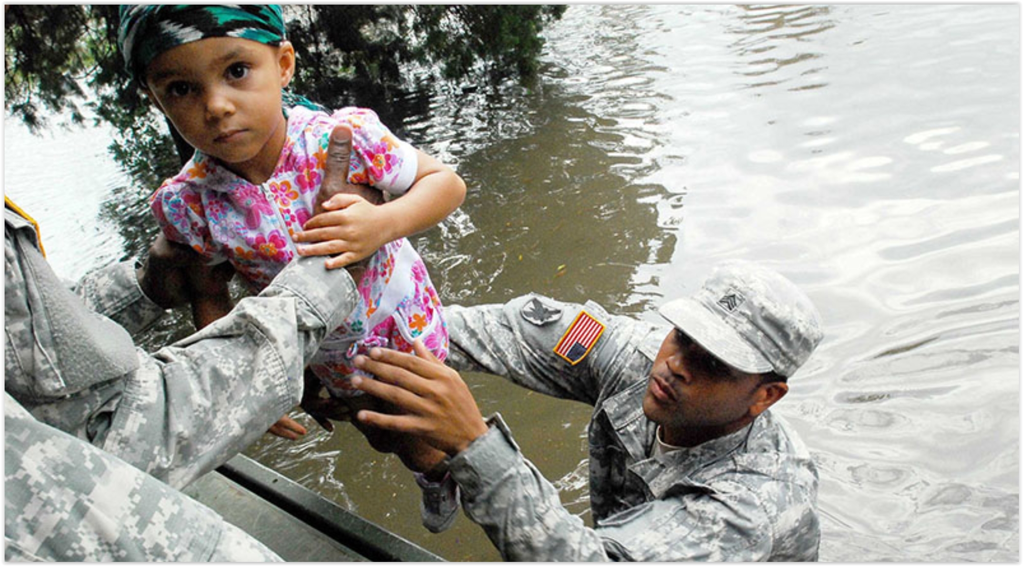
Climate Change Could Displace 140+ Million: From Climate Nexus: “Climate change could cause as many as 143 million people in three regions of the world to be displaced by 2050, according to the World Bank. In a new report, the World Bank estimates that 2.8 percent of the population of Sub-Saharan Africa, South Asia, and Latin America could be forced to move if emissions continue unchecked. However, researchers stress that curbing emissions now could help migration stay in check, estimating that keeping limits set by Paris Agreement targets could lower the number of migrants in these three regions to 40 million people in the same timeframe. The report comes as Donald Trump’s nominee to head the UN migration agency defended past controversial social media posts, including posts denying climate change, to reporters Monday.” (World Bank: The Guardian, Reuters, Time, Mashable. Trump nominee: AP).
File image: U.S. Army.
Can Climate Litigation Save the World? Yes, the lawyers will be paid. Here’s an excerpt from The Guardian: “Global moves to tackle climate change through lawsuits are poised to break new ground this week, as groups and individuals seek to hold governments and companies accountable for the damage they are causing. On Tuesday, action by 12 UK citizens reaches the high court for the first time, while on Wednesday in San Francisco, the science of climate change will effectively be on trial at a key moment in a lawsuit. The litigation represents a new front of climate action, with citizens aiming to force stronger moves to cut carbon emissions, and win damages to pay the costs of dealing with the impacts of warming…”
Photo credit: “Those bringing climate litigation hope to force governments to act and companies to pay damages for their role in causing global warming.” Photograph: Oliver Berg/EPA.
