Tornado Drill Day Is Thursday!
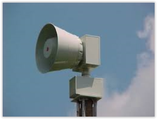
Unlike the technical malfunction that allowed the tornado sirens to sound Tuesday morning in Hennepin County, when you hear the sirens go off late today (Thursday) they are actually supposed to! As part of Severe Weather Awareness Week in the state, two statewide tornado drills will occur. More information on when they will be sounded from the Twin Cities NWS office:
1:00 PM: The National Weather Service will issue a simulated tornado watch for Minnesota and Wisconsin.
1:45 PM: The National Weather Service will issue a simulated tornado warning all of Wisconsin. Note that most cities and counties will activate outdoor warning siren systems.
1:45 PM: The National Weather Service will issue a simulated tornado warning for Minnesota counties. Note that most cities and counties will activate outdoor warning siren systems.
2:00 PM: The National Weather Service will issue an “End of Test” message using the Severe Weather Statement product. It should be stated that outdoor warning sirens will not be sounded again for this all clear, nor will there be any warning tone on NOAA Weather Radio.
6:55 PM: Another simulated tornado warning will be issued for Minnesota and Wisconsin counties.
Today is a good day to remind yourself what you would do if a Tornado Warning is issued for your area. Click this link for some safety tips from the Minnesota Department of Homeland Security and Emergency Management, including what to do if you are in a house, outdoors, in a vehicle or in a shopping mall.
_______________________________________________
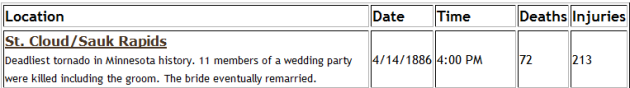
130-Year Anniversary. Not only is Thursday statewide tornado drill day, but it is also the 130-year anniversary of the deadliest tornado in Minnesota history. The tornado struck the St. Cloud and Sauk Rapids area late in the afternoon, killing 72 and destroying 80% of the building in Sauk Rapids. (Screenshot from the MNDNR’s Tornado History page.)
_______________________________________________
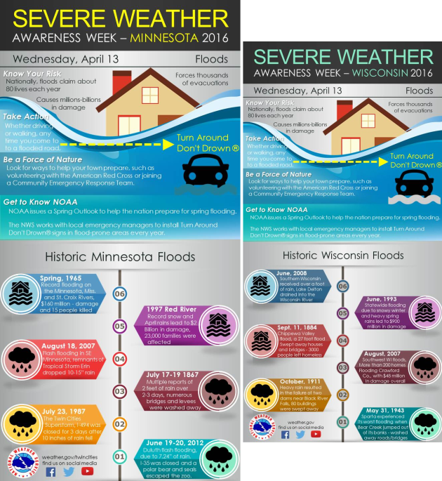
Severe Weather Awareness Week: Flooding. The topic of Severe Weather Awareness week in Minnesota and Wisconsin Wednesday was flooding. Here are some graphics NWS Twin Cities posted on twitter that focused on the topic and included some historic floods from both states.
_______________________________________________
Hazy Wednesday
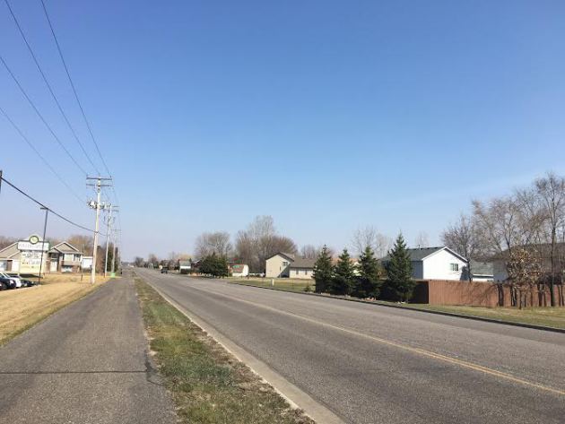
Did you notice some haze in the sky Wednesday across southern Minnesota? You wouldn’t be the only one. I took this photo in the St. Cloud area in the late afternoon hours.
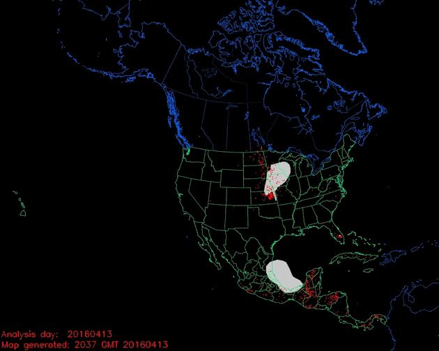
Smoke and Fire Analysis courtesy of NOAA Satellite and Information Service
All that haze was due to smoke from wildfires across Kansas and Nebraska drifting northward as well as some spot fires across southern Minnesota throughout the day. This did cause air quality values to rise into the moderate range due to the fine particles in the air.
_______________________________________________
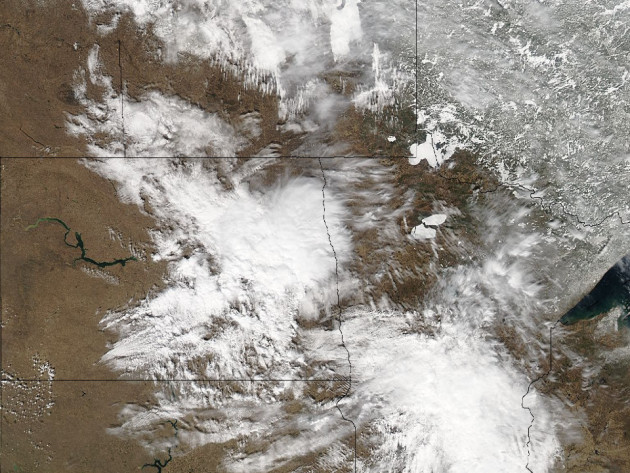
MODIS satellite image from Tuesday.
Ice Still Across Some Northern Minnesota Lakes. While numerous lakes across southern Minnesota saw early ice outs, there are still some lakes across northern Minnesota with ice on them, including Red Lake (which sees an average ice out date of April 29) and Lake of the Woods (average ice out date: May 2). This high resolution satellite image, however, shows a crack in lower Red Lake Tuesday.
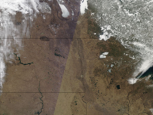
MODIS satellite image from Wednesday.
Since it was a clear day across the region Wednesday, you could easily tell which lakes still had ice on them across northern Minnesota. You could also see what is left of the snow across portions of the Arrowhead. For the latest ice out information from the Minnesota DNR, click here.
_______________________________________________
Spring Fever Warning – Atmospheric Euphoria
By: Paul Douglas
Flurries on a Tuesday, 70s on Thursday? Welcome to spring on the prairie. A light-switch spring. Flip a switch – cue the oohs & aahs. I predict precious little will get done today. Job productivity and test scores will suffer. That stuff on your to-do list? Forget about it.
Winter was fairly tame (thank you El Nino!) but the arrival of sustained 70s is always cause for celebration. I got so excited I set off the sirens Wednesday morning. My bad.
NOAA data shows more deaths from flash flooding than tornadoes in Minnesota over the last 30 years. A foot of rapidly moving water can sweep a small car downstream; 2 feet can float an SUV or truck. “Turn around – don’t drown” is good advice indeed.
Nothing severe is brewing, but a few instability T-showers may bubble up over the weekend. 70s are likely into Saturday, cooling into the 60s next week. No more wintry slaps looking out 2-3 weeks; no slush or windchill-babble lurking over the horizon.
Americans living in the south and west take 70s for granted. Not Minnesotans. Soak it up now – before bugs & humidity crash the party!
_______________________________________________
Extended Twin Cities Forecast
THURSDAY: Lukewarm sunshine. High 72. Low 52. Chance of Precipitation: 0%. Wind S 15-25 mph.
FRIDAY: Partly sunny, a balmy breeze. High 73. Low 55. Chance of Precipitation: 10%. Wind S 15-25 mph.
SATURDAY: More humid, stray T-shower. High 72. Low 57. Chance of Precipitation: 50%. Wind S 10-20 mph.
SUNDAY: Morning shower, then slow clearing. High 63. Low 45. Chance of Precipitation: 60%. Wind N 8-13 mph.
MONDAY: Intervals of sun, light winds. High 63. Low 43. Chance of Precipitation: 10%. Wind E 5-10 mph.
TUESDAY: Mix of clouds and sun, pleasant. High 67. Low 46. Chance of Precipitation: 10%. Wind E 5-10 mph.
WEDNESDAY: Fair weather holding pattern, dry. High 70. Low 49. Chance of Precipitation: 10%. Wind NE 5-10 mph.
_______________________________________________
This Day in Weather History
April 14th
1983: A ‘surprise’ snowstorm covers east central Minnesota. The Twin Cities receives 13.6 inches, the all-time record for April. Brilliant blue skies and bright sun appear the next morning.
1886: The deadliest tornado in Minnesota’s history rips through St. Cloud and Sauk Rapids, leaving 72 people dead. 80 percent of all buildings in Sauk Rapids would be leveled as the tornado’s width expanded to 800 yards. As it crossed the Mississippi it knocked down two iron spans of a wagon bridge and local witnesses said the river was ‘swept dry’ during the tornado crossing. 300,000 dollars damage would occur in Sauk Rapids, only 4,000 dollars of which was insured. The forecast for that day was for local rains and slightly warmer with highs in the 50’s.
_______________________________________________
Average Temperatures & Precipitation for Minneapolis
April 14th
Average High: 57F (Record: 89F set in 2003)
Average Low: 37F (Record: 18F set in 1928)
Average Precipitation: 0.09″ (Record: 1.56″ set in 1983)
Average Snowfall: 0.1″ (Record: 13.6″ in 1983)
________________________________________________
Sunrise/Sunset Times for Minneapolis
April 14th
Sunrise: 6:29 AM
Sunset: 7:58 PM
*Length Of Day: 13 hours, 28 minutes and 42 seconds
*Daylight Gained Since Yesterday: ~3 minutes & 0 seconds
*Next Sunrise That Is Before 6 AM: May 3rd (5:59 am)
*Next Sunset That Is After 8 PM: April 16th (8:01 pm)
Thursday Minnesota Weather Outlook
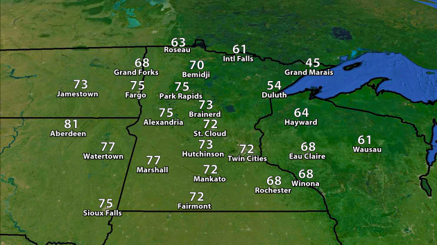
On the back of strong southerly winds (gusting up to 30 mph at times) highs will soar into the upper 60s and 70s across the southern two-thirds of the state Thursday. I’m expecting 72 in the Twin Cities Thursday, which would be the warmest we’ve been so far this year. The coolest temperatures across the state will be along Lake Superior with a breeze off the lake.
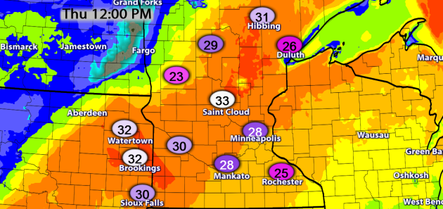
Winds will pick up as we head through the morning hours, and most of the state could see wind gusts in the 20-35 mph range during the midday and in the afternoon.
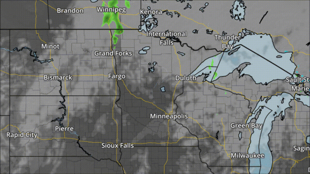
Forecast cloud cover and precipitation every three hours between 7 AM Thursday and 7 AM Friday. Graphic: AerisWeather’s Mapping Platform.
It’s looking like a fairly nice day across much of southern Minnesota Thursday, with the only thing to worry about being a few passing clouds and breezy conditions. The possibility exists for a few more clouds across northern Minnesota during the day along with an isolated storm or two possible.
________________________________________________
National Weather
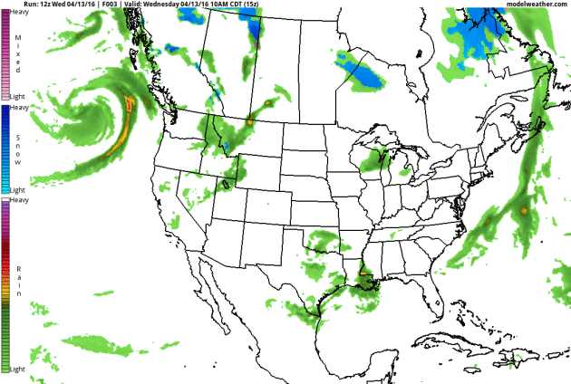
Taking a look nationally – first, a storm diving into the Pacific Northwest will bring parts of that region a couple inches of rain Thursday. We’ll be watching heavy rain and severe weather in the central part of the nation to end the week as an upper level low cuts off and very slowly moves east – potentially not moving out of the region until next Tuesday. Meanwhile, a stationary front near the Gulf Coast will lead to heavy rain (in excess of two inches) and potentially flooding through Thursday.
Severe Weather Outlook for Thursday.
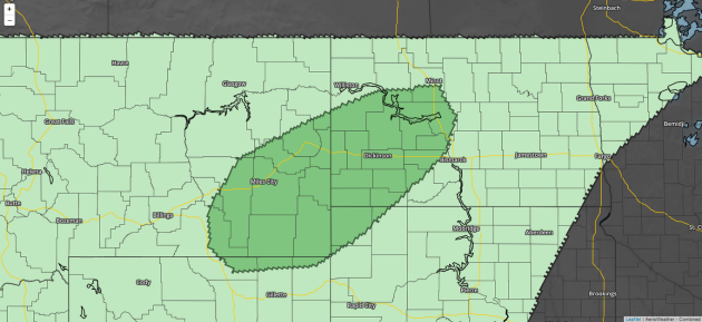
Severe weather will be possible across parts of the northern High Plains Thursday, with the threats being hail and wind.
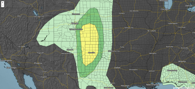
Severe Weather Outlook for Friday.
A larger severe threat exists Friday across the central and southern High Plains. The main threats will be large hail and isolated tornadoes.
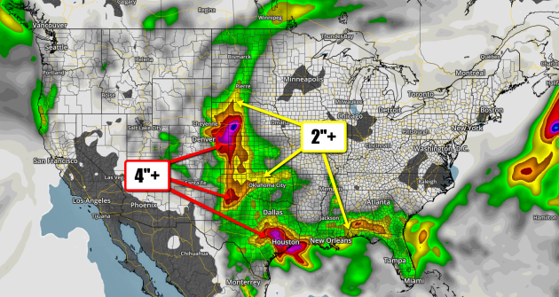
Forecast rain through Tuesday
Heavy rain is possible in the High Plains and along the Gulf Coast over the next few days. The best chance along the Gulf Coast will be through the end of the week, while the heaviest rain in the central U.S. will come Friday through the weekend and into early next week.
________________________________________________
Thanks for checking in and have a great Thursday! Don’t forget you can follow me on Twitter (@dkayserwx) or on Facebook (Meteorologist D.J. Kayser)!
– D.J. Kayser

