Snowstorm On The Way
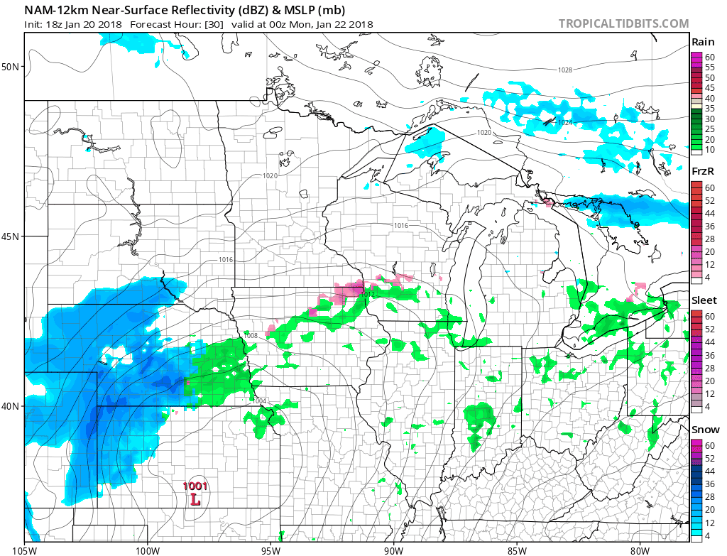
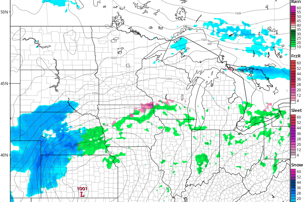
Ready for the next snowstorm of the winter? Well, it’s on the way as we head into Sunday Night and especially Monday. While light snow will start in southwestern Minnesota Sunday Night, the greatest impacts on the Twin Cities will be during the day Monday with moderate to heavy snow for a number of hours across southern Minnesota. This will easily impact both the morning and evening commutes in the Twin Cities. This simulated radar GIF shows 6 PM Sunday through 6 AM Monday.
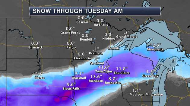
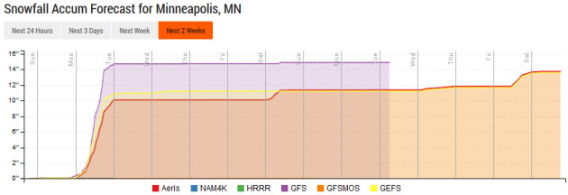
Looking at expected snow totals (as of Saturday night), the greatest potential of 6-12″ of snow will be across parts of southern Minnesota, potentially including the Twin Cities.
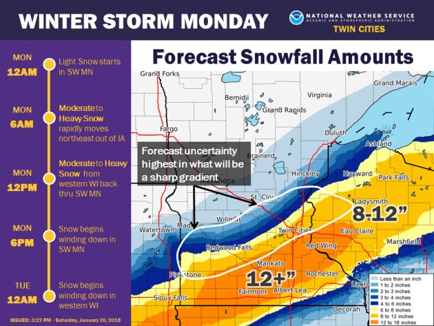
This graphic from NWS Twin Cities shows not only the timeline of snow across the region, but where there is uncertainty in snow totals. That uncertainty is on the northern side of the system as we typically see in systems like these, and unfortunately does include a good portion of the Twin Cities. We’ll have a better idea as we head throughout Sunday where that sharp gradient may occur.
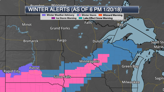
As of Saturday Night, Winter Storm Warnings have been issued for southern Minnesota and western Wisconsin across areas that have the highest potential of seeing 6″+ of snow late Sunday into Monday.
_______________________________________________
Snow Deficit Continues Across The State
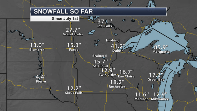
The good news with the potential snowstorm? We could use the snow. We have only received just over a foot of snow in the Twin Cities so far this winter, with just under 16 inches in St. Cloud. Larger snow totals have been observed to the north, with over 37″ in the Ice Box of the Nation and over 41″ in Duluth.
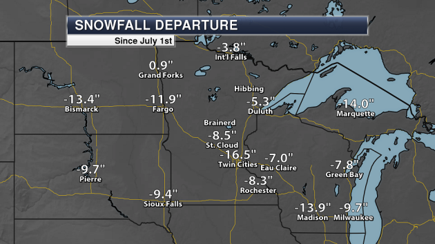
We are over 16″ below average so far this winter snowfall-wise in the Twin Cities, making any outdoor snow activities hard across the region. And even though parts of northern Minnesota have seen over three feet of snow, both International Falls and Duluth are still below average by a few inches.
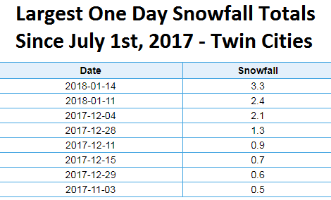
We have only observed four days so far this winter with over one inch of snow falling in the Twin Cities – the largest occurring last Sunday with 3.3″ of snow fell for the Minnesota Miracle game.
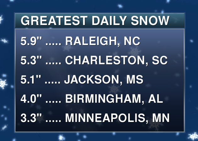
Sadly, that means parts of the Southeast have received more snow in one day so far this winter than the Twin Cities! Maybe our luck will change over the next couple days.
_______________________________________________
Record Highs Friday Across Northern Minnesota
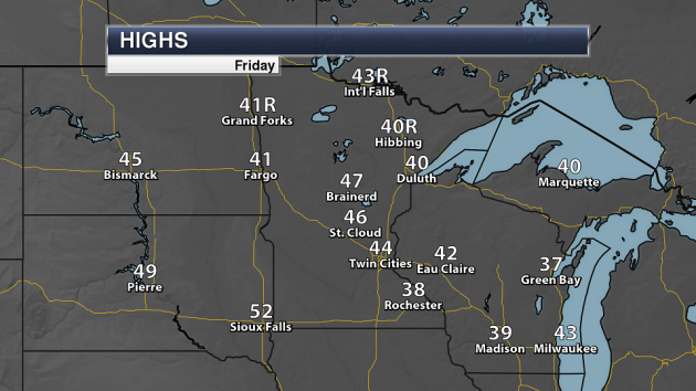
But the top of this blog isn’t all just snowy news – we actually saw record highs in International Falls and Hibbing Friday as temperatures climbed into the 40s!
_______________________________________________
Southern Third of State to See a Plowable Snowfall
By Paul Douglas
“Snowstorm. Noun. A heavy fall of snow, especially with a high wind.” Wait, I vaguely remember these things from my youth. Big, thick, snowy quilts of white that would come up to my chin. Granted, I was only 2 feet tall at the time. Whatever.
Suspend your disbelief, set aside perpetual skepticism. A big, meaty, respectable snowfall is increasingly likely tomorrow. Models are now in rough agreement, including ECMWF (European) guidance, showing a band of 5-10 inches over roughly the southern third of Minnesota.
At this point in our chat you’re thinking: “Paul, what can go wrong, and what time?” A storm track 50-100 miles farther south could leave MSP with only a couple inches. There’s a 1 in 4 chance of this unfolding, but odds favor enough snow to shovel, plow, and turn your PM commute Monday into a holy terror.
No worries today getting to your Vikings party. Snow arrives later tonight; falling at 1-2 inches/hour at times Monday. Leave plenty of extra time to get around.
Skeptical? Me too. But at some point the law of averages catches up with you. Let it snow. Please.
_______________________________________________
Extended Twin Cities Forecast
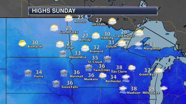
SUNDAY: Gray, wet roads. High 38. Low 29. Chance of precipitation 20%. Wind NE 5-10 mph.
MONDAY: Heavy snow, potential for 5-10″. High 31. Low 15. Chance of precipitation 100%. Wind NE 15-30 mph.
TUESDAY: Peeks of sun, better travel conditions. High 25. Low 11. Chance of precipitation 10%. Wind NW 7-12 mph.
WEDNESDAY: Mostly cloudy, probably dry. High 28. Low 13. Chance of precipitation 20%. Wind SE 5-10 mph.
THURSDAY: Patchy clouds, thawing out late. High 32. Low 28. Chance of precipitation 20%. Wind SE 8-13 mph.
FRIDAY: Cloudy, milder breeze kicks in. High 42. Low 27. Chance of precipitation 20%. Wind S 10-20 mph.
SATURDAY: Mostly cloudy, few flurries. High 33. Low 14. Chance of precipitation 30%. Wind NW 10-15 mph.
_______________________________________________
This Day in Weather History
January 21st
1936: Warroad drops to a bone-chilling 55 below zero.
1922: The barometer at Collegeville hits 31.11 inches, a record high pressure reading for the state.
_______________________________________________
Average Temperatures & Precipitation for Minneapolis
January 21st
Average High: 24F (Record: 48F set in 1900)
Average Low: 7F (Record: -41F set in 1888)
Average Precipitation: 0.03″ (Record: 0.81″ set in 1917)
Average Snow: 0.4″ (Record: 15.8″ set in 1917)
_______________________________________________
Sunrise/Sunset Times for Minneapolis
January 21st
Sunrise: 7:43 AM
Sunset: 5:05 PM
*Length Of Day: 9 hours, 22 minutes and 17 seconds
*Daylight Gained Since Yesterday: ~2 minutes and 7 seconds
*Next Sunrise at/before 7:30 AM: February 3rd (7:30 AM)
*Next Sunset at/after 5:30 PM: February 8th (5:31 PM)
_______________________________________________
Minnesota Weather Outlook
Snow will be rolling into southern Minnesota as we head into the overnight hours Sunday Night, otherwise mainly cloudy skies can be expected across most of the state Sunday. Highs will be in the 20s to 30s.
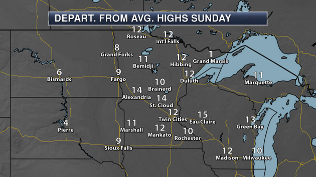
Even with the cloud cover expected, highs will be a good 10-15 degrees above average for this time of year on Sunday.
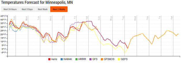
While we do see a dip in temperatures behind this system, it won’t be as drastic as it has been behind some previous storms. Highs will remain in the 20s and 30s through much of next week.
After our snowstorm over the next couple days, we will see a break in the snow department for a few days again, with the long range models not hinting at another snow chance until next weekend.
_______________________________________________
National Weather Forecast
A forming storm system will cause rain and snow across the central third of the nation on Sunday, with heavy snow likely for the upper Midwest by Sunday Night. Rain and snow will also spread into parts of the Northeast with this system. A frontal system will approach the west coast, bringing another round of rain and mountain snow from Washington into parts of California.
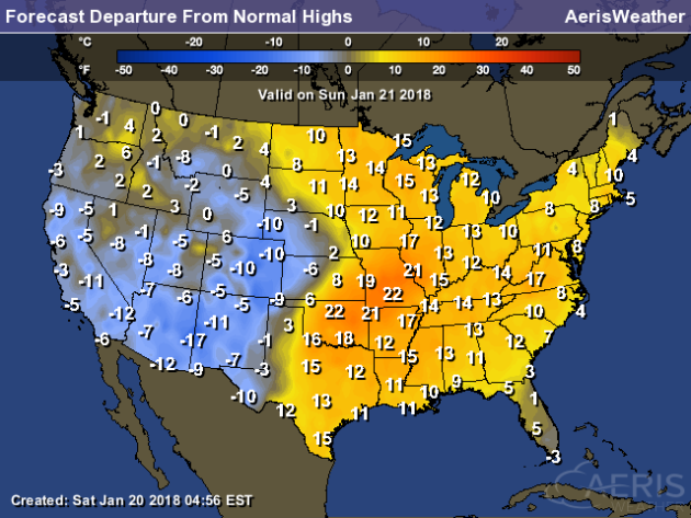
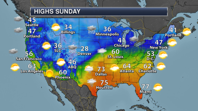
The eastern two-thirds of the nation will see mainly above average highs Sunday, which in some parts of the central Plains will be a good 20-25 degrees above average. The western United States will see mainly below average highs.
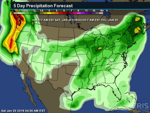
We’ll see heavy precipitation across both the Pacific Northwest and the eastern United States through next Thursday morning. The precipitation across the eastern U.S. is in association with the storm system that brings the upper Midwest snow Sunday into Monday. Meanwhile, two frontal systems will approach the west coast over the next five days – one Sunday, and another on Wednesday.
You can see the path of the snowstorm Sunday into the beginning of the week from the Rockies into the upper Midwest, with the potential of 6-12″+ along the axis of heaviest snow. Heavy snow will also be possible across the higher elevations in the west with that front moving ashore to end the weekend.
_______________________________________________
Increasing Fire Danger In Arizona
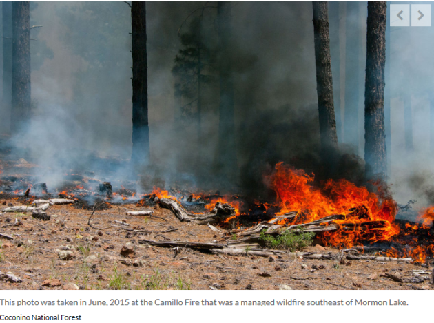
Dry weather the past few months could make firefighters needed earlier than normal across parts of Arizona. More from the Arizona Daily Sun: “A fall and winter defined by record or near-record dryness has skyrocketed the measures of fire risk around Flagstaff for much of the past several months, though the season’s first storm Jan. 10 did provide some respite. The dry conditions already have local forest managers looking at bringing on seasonal firefighting resources up to a month earlier than normal, said Duane Tewa, Coconino National Forest fire staff officer.”
Snow Drought In The Western U.S. Could Impact Water Supplies
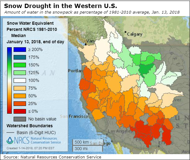
More from Inside Climate News: “Months of exceptionally warm weather and an early winter snow drought across big swaths of the West have left the snowpack at record-low levels in parts of the Central and Southern Rockies, raising concerns about water shortages and economic damage. Drought spread across large parts of the Western United States this month, and storms that moved across the region in early January made up only a small part of the deficit. Runoff from melting snow is now projected to be less than 50 percent of average in key river basins in the central and southern Rockies.”
________________________________________________
Thanks for checking in and have a great Sunday! Don’t forget to follow me on Twitter (@dkayserwx) and like me on Facebook (Meteorologist D.J. Kayser)!
– D.J. Kayser

