A Snowy Disconnect
Storm. noun: a violent disturbance of the atmosphere with strong winds and usually rain, thunder, lightning, or snow.
Oh, I remember those! Vaguely. A faded memory, right up there with prom dates and fax machines.
During a typical winter (ha!) MSP picks up 9 or 10 plowable snowfalls of 2 inches or more. So far this winter: 4 plowable snows, 2 of them in November. Our biggest “storm”? An awe-inspiring 3.4 inches on December 27.
It seems a bit surreal to be staring out at subzero temperatures with a paltry 1 inch of snow on the ground.
February in Wichita.
And just like last winter the jet stream has gotten stuck in a rut, a groove; relatively dry, harmless clippers sailing over Minnesota, intensifying into coastal monsters capable of burying Boston under 100″ of snow in the better part of 30 days. I still believe this is linked to rapid warming of the Arctic – we’ll see.
We’re making up for a milder than average December and January – and it now looks as if a prolonged thaw may not arrive until the second week of March. We struggle to top 0F Sunday; 2-3 more subzero mornings between now and next Thursday. If anyone asks (doubtful) we’ve enjoyed 21 mornings of negative fun. Last winter we endured 50 subzero lows. Feeling any better?
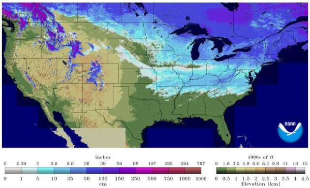
* 36.5% of the Lower 48 states are snow-covered, according to NOAA. That’s up from 25% on January 20.
Some Notes On Cold Temperatures. Some of the coldest mid-February temperatures over far northern Minnesota since 1966? Here’s an excerpt from Dr. Mark Seeley at Minnesota WeatherTalk: “…Seagull Lake set a new record low with -38F; Brimson and Embarrass set new record lows with a reading of -41F; Ely and Tower set new record lows with -37F; Orr reported a new record low of -36F; and Littlefork reported a record low of -34F. It is interesting to note that the places in the state that set new cold temperature records this week were areas that also have the deepest snow cover (a foot up to 30 inches). From a historical perspective these are the coldest mid-February low temperatures since those of 1966…”
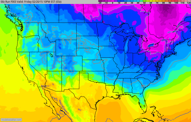
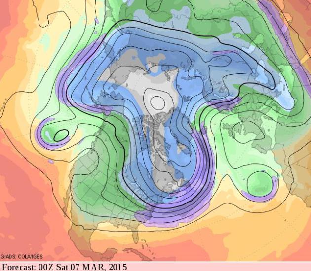
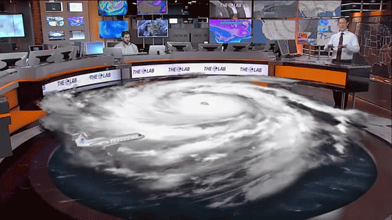
Respect The Purple. Purple, as in purple-pain. Everything shaded in light purple is subzero; dark purple is seriously cold air. 2-meter NOAA temperature forecast into early Tuesday from the 12km NAM. Animation: Ham Weather.
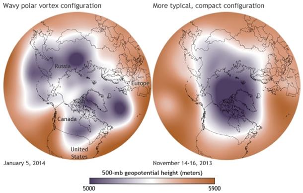
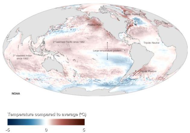
Weird Winter Weather Plot Thickens As Arctic Swiftly Warms. For a few years now I’ve been describing what I perceive as changes in the configuration of the jet stream over North America. At first I thought I was hallucinating, but recent research seems to suggest that rapid warming of the Arctic may, in fact, be impacting the shape and persistence of upper level steering winds. Here’s an excerpt of a post at The Conversation and Scientific American: “…Other studies suggest that Arctic warming in summer leads to a split jet stream—or two separated rivers of wind—which tends to trap the waves. Those stationary waves cause weather conditions to remain “stuck” for long periods, increasing the likelihood of extreme heat waves, droughts and flooding events in Eurasia and North America. Our own new work, published last month in Environmental Research Letters, uses a variety of new metrics to show that the jet stream is becoming wavier and that rapid Arctic warming is playing a role. If these results are confirmed, then we’ll see our weather patterns become more persistent…” (Image credit: NOAA).
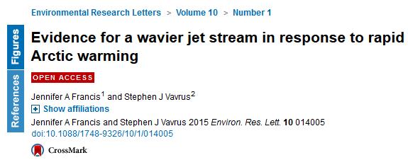
Evidence For A Wavier Jet Stream. A summary of Jennifer Francis’s latest research is here.
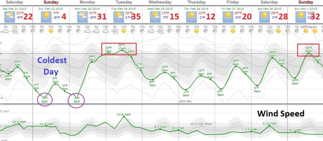
Numbing Sunday. Tomorrow will bring back memories of the January we never really had. Under a cobalt-blue sky the mercury struggles to blip above zero as the wind chill dips to -20 or colder. It’s unusually cold for late February, but hardly unprecedented. And the cold wave won’t last long with a thaw Monday night into Tuesday before a (weaker) push of Canadian air arrives by midweek.
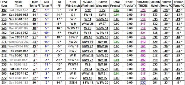
A Delayed Thaw? Yesterday guidance was suggesting 30s by the first week of March. The latest GFS model runs prolong the chill from the Upper Midwest and Great Lakes into New England into March 6-8, but milder Pacific air pushing into western Canada and the USA will eventually sweep in, probably second week of the month. Map: GrADS:COLA/IGES.
In Like A Caribou. Maybe I’m coffee-deprived, but March coming in like a lion just doesn’t cut it. I still don’t see any significant storm risk/opportunity for the next 2 weeks as prevailing jet stream winds blow from the west/northwest; any big storms sailing well south of Minnesota. Which has been the pattern for much of the winter, come to think of it.
Meteorology Professor Explains Extreme Weather Pattern. Speaking of a “stuck” jet stream, WGRZ.com in Buffalo has a story explaining how another unusually persistent jet stream configuration is resulting in either record warmth + drought, or mega-blizzards and polar cold; here’s an excerpt: “…Professor Stephen Vermette coordinates the Meteorology and Climatology Program at SUNY Buffalo State. He says we can blame these extreme weather patterns on the jet stream. “It’s been stuck in place and that’s week after week after week, especially February we’ve been getting some very cold temperatures while places like Montana and Idaho and California, even Alaska, are getting much warmer temperatures,” he says. Vermette says more than four-thousand warm temperature records have been set out west just this month alone. But on our side of the map, there have been about 250 cold temperature records set…”
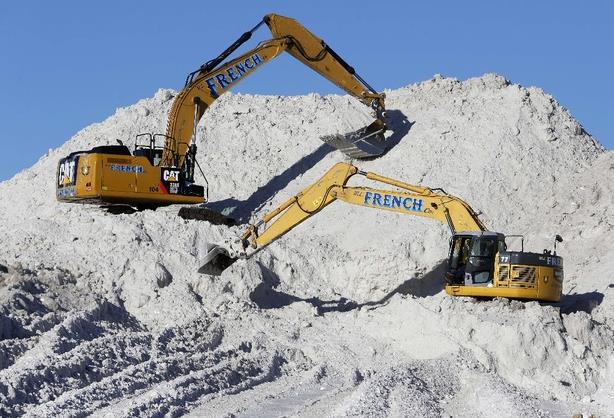
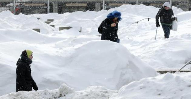
What Boston’s Snow Crisis Can Teach Us About Solving Problems in New Ways. CityLab has a fascinating article, including a few jaw-dropping statistics: “…It’s like a math problem you got on a test as a kid, or a puzzle game for your iPhone: Imagine you’re the mayor of Boston. In the last 30 days, your city has seen a whopping 6 feet of snow. How many cubic feet of snow have actually fallen on your city, and where do you put it all? Answer: A little over 8 billion cubic feet of snow, and no darn idea...”
Photo credit above: “Heavy equipment works on a mound of snow that has been cleared from city streets at a “snow farm” in Boston, Monday, Feb. 16, 2015.” (AP Photo/Michael Dwyer).
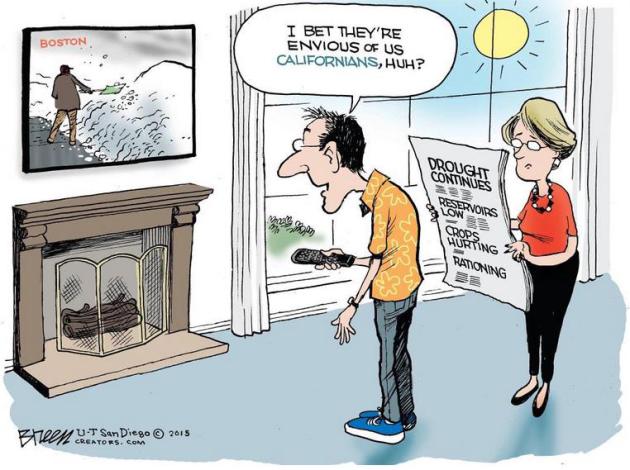
Ironic Captions Encouraged. Thanks to Steve Breen at U-T San Diego for summarizing another all-or-nothing weather proposition.
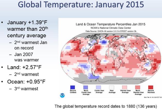
Second Warmest January On Record, Worldwide. NOAA NCDC has an interesting PDF with highlights of January, and the winter, to date. Only January 2007 was warmer than last month.
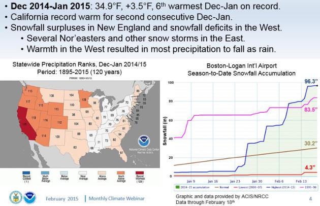
A Tale of Extremes. California has been experiencing record warmth, while Boston is digging out from a near-record winter of snow, a parade of coastal storms since late January. I still suspect Minnesota’s winter will be close to average overall, colder than average weather in November and February compensating for milder than normal weather in December and January.
2015 Picks Up Where 2014 Record Heat Left Off. Here’s a snippet from a post at Climate Central: “…All three agencies ranked 2014 as the warmest year on record by a slim margin, driven by the accumulation of heat-trapping greenhouse gases in the atmosphere. Nine of the 10 hottest years on record have all occurred in the 21st century, with the exception of the blockbuster El Nino year of 1998. There hasn’t been a record cold year set since 1911, while during the same period there have been 19 record-warm years, according to a Climate Central analysis…”
Boston’s Billion Dollar Blizzard. Wait, people don’t shop when there’s 7-9 feet of snow on the ground? I had no idea. The impact on America’s economy probably won’t be as severe as last winter. Here’s an excerpt of a post at PYMNTS.com: “…As further evidence to those who want to make the case of how bad this winter is, economic data suggest that this winter could cost the economy nearly $2 billion in lost GDP, according to research firm Planalytics — and winter has about a month more to go officially. This would be largely caused by retail losses from having to close because of weather conditions, re-routed travel patterns, public transportation that might not be running at full capacity until Easter, as well as other business headaches...”
Photo credit above: “As snow flurries begin to fall again, pedestrians walk through Boston City Hall Plaza in Boston, Tuesday, Feb. 17, 2015. Nearly 8 feet of snowfall this winter has paralyzed greater Boston’s transit system, infuriating commuters on and off the rails who may not see a return to normal for at least a month.” (AP Photo/Charles Krupa)
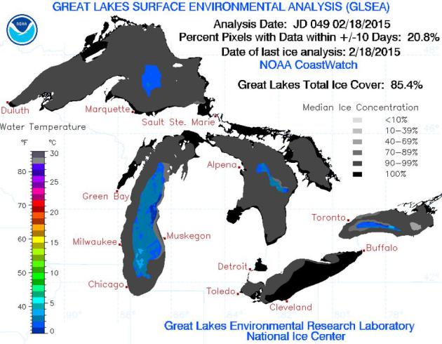
Second Greatest Great Lakes Ice Cover Since 1996. Number one was last year, with 92.5% coverage on March 6, 2014. According to NOAA’s Great Lakes Environmental Research Laboratory the current number stands at 85.4% ice covered, and with cold weather lingering into the end of next week I expect it to rise into the upper 80s, but probably not break the all-time record set in 1979.
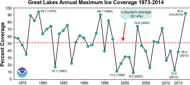
Icy Perspective. Great Lakes ice is a good proxy for the overall severity of a winter, since it factors duration of bitter cold necessary to form thick lake ice. Other cold years include 1979, 1994 and 2014. Source: NOAA.
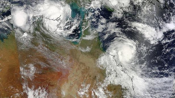
Cyclone Lam and Cyclone Marcia: Twin Severe Storms A First For Australia. Dueling cyclones – a bit unusual down under; here’s a snippet from Sydney Morning Herald: “Australia’s northern coasts are being battered by two severe tropical cyclones on Friday, the first time meteorologists have seen twin storms of such intensity making near-simultaneous landfall. Cyclone Lam crossed the Northern Territory coast about 20 kilometres east of the town of Milingimbi as a category 4 cyclone overnight, knocking out two wind monitors in the process. It has been downgraded to a category 3 as the storm moves inland…” (NASA).
Why Can You Fly Into A Hurricane, But Not A Thunderstorm? Hurricane winds gradually build over time, but violent updrafts and downdrafts, along with severe icing and hail over a short distance can increase the stress – and risk – to aircraft. Here’s an excerpt of a good explanation at Huffington Post: “…In short, it all boils down to the type of wind pilots face in either scenario. In the case of a hurricane, a pilot navigates through a “stratified area of horizontal winds,” which allows for a relatively smooth ride. Pilots flying in a thunderstorm, on the other hand, are faced with “strong vertical winds,” going upward and downward, which can cause turbulence and other issues. Just check out a new video (above) from The Weather Channel, which explains the difference between flying in the two weather conditions….”
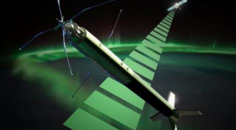
Rocket Flown Through Northern Lights To Help Unlock Space Weather Mysteries. Gizmag has the story; here’s the introduction: “The northern lights are more than one of nature’s most awe inspiring sights, they are an electromagnetic phenomena that can adversely affect power grids and communications and navigation systems. Researchers from the University of Oslo have flown a rocket through the phenomena to take a closer look with the aim of gathering data that will help in predicting space weather…”
Image credit above: “Artist’s depiction of the ICI-4 rocket which launched today.” (Image: Trond Abrahamsen, Andøya Space Center).

Apple Wants To Start Producing Cars As Soon As 2020. Will they buy Tesla to jump-start their development efforts? It’s no longer about digital devices, soon it will be a digital lifestyle, including new transportation options. Here’s a clip from a story at Bloomberg Business: “…Tesla’s success in creating a startup car company has shown that the traditional barriers of entry into the auto industry aren’t as difficult to overcome as originally thought, said one person, who asked not to be identified because the matter is private. At the same time, automakers have struggled to bring technical leaps to car development, something that Silicon Valley is also seeking to accomplish. For example, Google Inc. has invested in developing an autonomous vehicle since 2010…” (Image courtesy of iJailbreak).

Coffee’s Good For You! No, really. And if you don’t believe the headline check out the story at Bloomberg; here’s an excerpt: “A couple of grandes a day may keep the doctor away, according to a panel of government-appointed scientists charged with proposing changes to U.S. dietary guidelines. Just go easy on the sugar. Three to five daily cups of coffee aren’t associated with long-term health risks, the panel said in a report Thursday, and correlate with reduced risk for heart disease and type 2 diabetes. The panel helps the U.S. government formulate dietary suggestions, guidelines that affect millions of American diets…”
TODAY: Mostly cloudy, turning colder. Winds: NW 15. High: 19
SATURDAY NIGHT: Clearing, plenty cold. Low: -8
SUNDAY: Cold blue sky. Groundhog was right. Windchill near -20. High: 3
MONDAY: Cold start. Breezy, turning milder with increasing clouds. Wake-up: -9. High: 21
TUESDAY: Mild start, cooling down late. Wake-up: 20. High: 33 (falling by afternoon)
WEDNESDAY: Partly sunny. No relief yet. Wake-up: 7. High: 15
THURSDAY: Really enjoying February! Some sun. Wake-up: -1. High: 14
FRIDAY: Sunny intervals, light winds. Wake-up: 1. High: 20
Climate Stories….
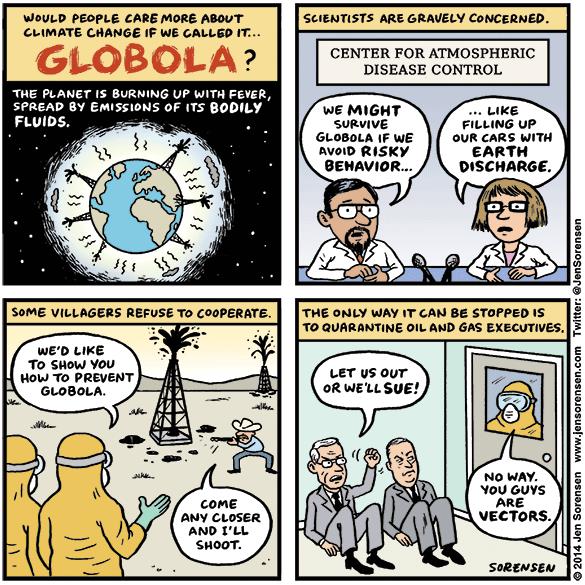
Globola. If it had a scarier name than climate change would we still be sitting on our hands and “debating” the science? Maybe not. Who knows. But Jen Sorensen nails it in this comic.
6 in 10 Americans Have Given Climate Change and Health “No Thought”. Here’s the intro to a story at weather.com: “Has climate change affected your area? You might not think it, but the answer is yes. “Every American, whether they know it or not, has been affected by climate change,” Edward Maibach, the director of George Mason University’s Center for Climate Change Communication, told weather.com. One of the most prominent ways it is already impacting the U.S. is through health. But most Americans have no concept of the complex intersection between their health and the environment, a report, “Public Perceptions of the Health Consequences of Global Warming,” published in October 2014, indicated…”

Fight Climate Change, Make Money. So says Virgin founder Richard Branson in an Op-Ed at CNN; here’s a clip: “…Codifying this goal into the international agreement that’s taking shape would send the strongest possible market signal that there’s money to be made in taking climate change seriously. A net zero position allows business leaders to take short-term action and make long-term plans to develop profitable ways to be competitive, even as they limit emissions, increase efficiency and find strategies to offset the remaining emissions that can’t be avoided…”

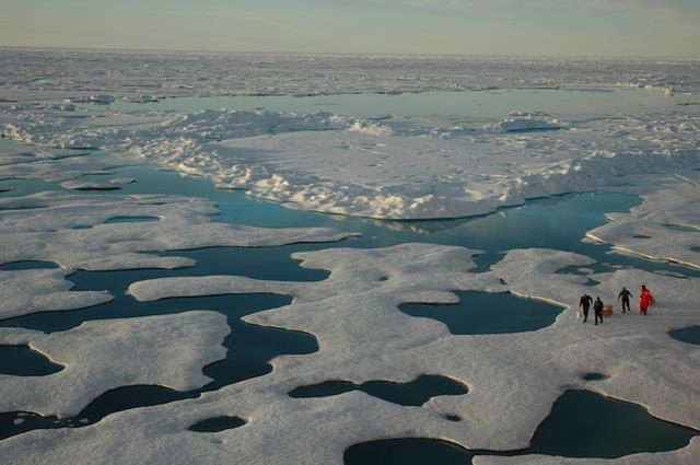
The Pentagon and Climate Change: How Deniers Put National Security At Risk. The Navy is no longer “debating” climate change – they can already see it in their installations and ports around the world. Here’s a clip of an important story at RollingStone: “…Rear Adm. Jonathan White, the Navy’s chief oceanographer and head of its climate-change task force, is one of the most knowledgeable people in the military about what’s actually happening on our rapidly heating planet. Whenever another officer or a congressperson corners White and presses him about why he spends so much time thinking about climate change, he doesn’t even try to explain thermal expansion of the oceans or ice dynamics in the Arctic. “I just take them down to Norfolk,” White says. “When you see what’s going on down there, it gives you a sense of what climate change means to the Navy — and to America. And you can see why we’re concerned…”