74 F. high in the Twin Cities Saturday.
78 F. average high on August 29.
80 F. high on August 29, 2014.
August 29, 1948: An airliner crashed during a thunderstorm near Winona, killing 37 people on board.
August 29, 1863: A devastating killing frost affected most of Minnesota, killing vines and damaging corn.

Cluttered Houses
I get my best material at the State Fair. “Paul, the weather has been TOO NICE this summer. I haven’t had any time to declutter my home!” said Marilyn from Plymouth. Yes, it has been a remarkable summer, all things considered.
Which brings up an interesting metaphysical question: can the weather be too nice? Let’s ask someone in San Diego or Honolulu. All that nice, bright, boring sunshine. How do people find the will to work out there?
No big tornadoes, no drought, no nasty rashes of 90-degree heat? It has been a perfect summer; as good as it gets. And it’s not over yet.
The bloated ridge of inflamed air that stalled over the western USA this summer pushes east this week, treating Minnesota to a streak of 85-90F degree days from Monday into Friday; one of the hotter stretches of the summer.
Expect murky sunshine again today. Smoke from western wildfires will give the sky a milky appearance – like peering up from the bottom of a dirty aquarium (which I don’t recommend).
A midweek rumble of thunder is possible but most of us won’t see T-storms until Saturday night & Sunday. A puff of cooler, drier air arrives just in time for Labor Day.
Not perfect but we’ve seen worse.

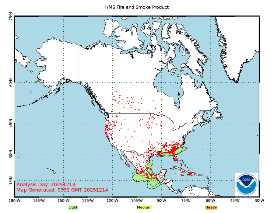
A Risk of Smoke. The map above shows the aerial extent of yesterday’s smoke plume, a massive plume of smoke from fires still burning out of control from Washington State into Idaho and Montana. Map: NOAA.

A Dirty Sky. Yesterday’s visible satellite loop showed the veil of smoke pushing in from the Dakotas and Manitoba, giving the sky a milky, almost eerie appearance. And I’m fairly convinced the smoke plume kept us cooler. Cirrus clouds can keep afternoon highs 2-4F cooler than they would be otherwise. A thick pall of smoke may have a similar or even greater ability to screen sunshine, keeping surface temperatures cooler. That may be part of the reason why the MSP metro high was only 74F. Imagery: WeatherTap.
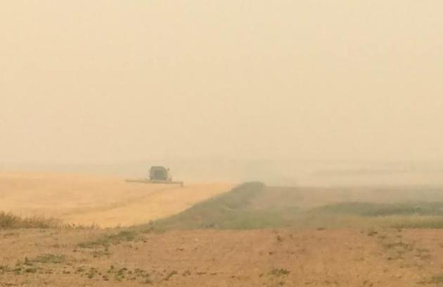
North Dakota – Or Mars? AerisWeather meteorologist Todd Nelson forwarded this image from a family member in Alamo, North Dakota, in the northwest corner of the state. They were combining yesterday, visibility greatly reduced due to smoke from western fires.

84-Hour NAM Model Output. The best chance of flooding rains from the soggy remnants of Erika will come Sunday evening into Monday night. A persistent ridge of high pressure keeps Minnesota warm, sticky and smoky through the end of the week. Meanwhile heavy showers push into the Pacific Northwest, hopefully taking the edge off the worst of the wildfires burning from Washington to Montana.
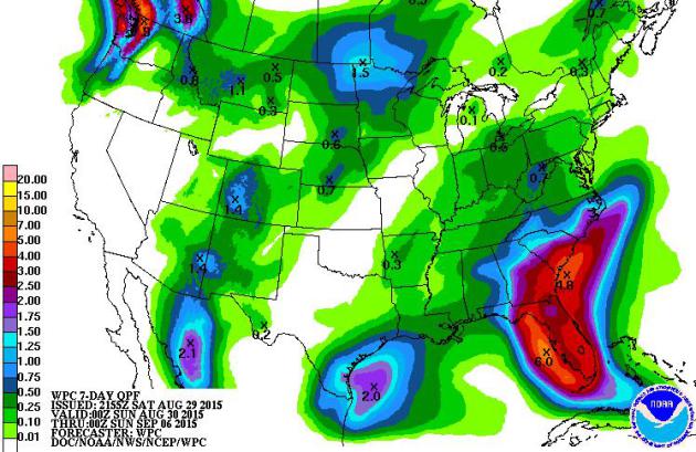
Southeastern Soaking. NOAA’s 7-Day model ensemble prints out some 4-8″ rainfall amounts from Florida into coastal Georgia and South Carolina. Just because Erika has fizzled doesn’t mean the flood risk has passed. Weak, slow-moving tropical systems are often deceptive; people let their guard down, only to be flooded out of their homes.
* Tropical Storm Erika weakens into a tropical depression over eastern Cuba. Probability of re-strengthening into a hurricane is low, but there is a small chance that this system could regenerate into a tropical storm again as it approaches Florida or the eastern Gulf of Mexico. We need to continue monitoring this system.
* Although the risk of hurricane impacts over Florida, the Gulf Coast or Southeastern USA are small, excessive rains are still likely, especially over Florida, where the risk of flash flooding will be elevated from Sunday into Tuesday.
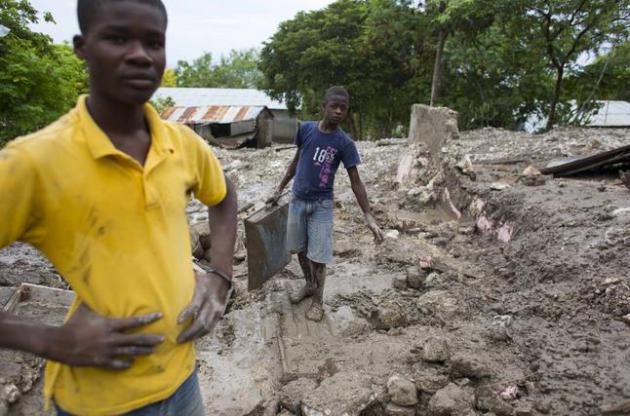
Photo credit above: “Residents work to salvage personal items from the site of a mudslide in rain-soaked Montrouis, Haiti, Saturday, August 29, 2015. Erika dissipated early Saturday, but it left devastation in its path on the small eastern Caribbean island of Dominica, authorities said. In Haiti, one person died in the mudslide just north of Port-au-Prince.” (AP Photo/Dieu Nalio Chery)
Situation Report:
* Intense rains flooded the Dominican Republic on Friday, with a personal weather station in Barahona reporting over 24 inches of rain. That station also reported an astonishing 8.80 inches of rain in one hour from 8 p.m. to 9 p.m. Friday.
* A band of torrential rain also resulted in deadly flash flooding on the island of Dominica in the Lesser Antilles, Thursday. Roads were washed out, homes were damaged and an airport flooded.
* Canefield Airport near the capital of Roseau, Dominica, picked up 12.64 inches (322.4 millimeters) of rain in a 12-hour period ending just before 2 p.m. EDT Thursday. Source: The Weather Channel.
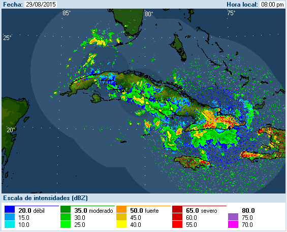
Ripe for Flash Flooding. With an additional influx of tropical moisture from the Caribbean conditions remain ripe for flash flooding across Florida over the next 72 hours. Facilities that often flood may experience drainage issues between Sunday and Tuesday of next week. Latest Cuba radar here.
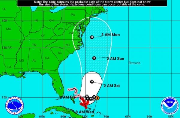
Swath of Concern. Although downgraded into a tropical wave/depression, the moisture leftover from Tropical Storm Erika will stream toward Florida and the eastern Gulf of Mexico, creating a ripe environment for flooding T-storms capable of 5″+ rainfall amounts. It’s still premature to lower your guard, especially for locations in Florida. Here is an excerpt from the latest discussion from The National Hurricane Center:
The remnants are expected to move west-northwestward near the
northern coast of central and eastern Cuba for the next 12 to 24
hours and reach the southeastern Gulf of Mexico in about 36 hours.
After that time, a more northward motion is expected over the
eastern Gulf of Mexico.

The dynamical models suggests that the current strong wind shear
could relax by the time the system reachs the Gulf of Mexico, and
there is a possibility that Erika could regenerate.  Regardless of
regeneration, locally heavy rains and gusty winds should spread
across portions of Cuba, the Bahamas, and southern Florida during
the next couple of days.
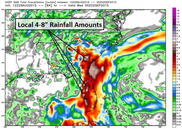
84-Hour Forecast Rainfall. NOAA’s NAM model still prints out locally excessive rainfall amounts from Florida into Georgia by midday Tuesday. It’s impossible to predict with any accuracy which cities in Florida and Georgia might experience flash flooding. Remember that flooding from slow-moving tropical systems can create more serious flooding than fast-moving hurricanes. Bottom line: stay alert and prepare for potential urban and small stream flooding from Miami and Naples to Orlando, Jacksonville and Augusta, Georgia. Map above: WeatherBell.
Summary: Erika has weakened to “depression” status, the result of wind shear, dry air and interactions with mountainous terrain over the Dominican Republic. Although the risk of a full-blown hurricane has diminished, flash flood concerns remain, especially for FLorida and coastal Georgia from Sunday into Tuesday. Facilities and operations may still be negatively impacted. Stay alert; more briefings will be issued as required.
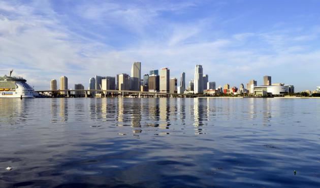
10 Years After Katrina, Miami Very Vulnerable to Hurricane Hit. Here’s a clip from a video and story at NBC News: “…Of the 20 large (global) cities that people talk about as being highly at risk for coast storms, about eight of them are on the American coast: the East Coast and the South coast,” said Greg Baecher, a professor of engineering at the University of Maryland. “If a Katrina directly hit Miami, you are talking about damages that could be several multiples of what happened in New Orleans,” Baecher told CNBC. “First, you have the size of the city, and the fact that there is nothing between the coast and the ocean...”
Photo credit: Wikipedia.
Billions Spent on Flood Barriers, But New Orleans Still a “Fishbowl”. The number I heard from PBS News Hour was $14 billion, which is a staggering sum. It doesn’t help that the city is actually situated below sea level. Will the new and improved (and wildly expensive) levees and storm barriers hold? Only time will tell. Here’s an excerpt from WUNC: “…Flood protection” is a loaded term. The Army Corps of Engineers prefers to call it a “risk reduction system.” The new system is designed to withstand a 100-year hurricane or a storm that has a 1 percent chance of occurring each year, and to significantly reduce flooding from a 500-year cyclone. “We changed that lexicon after Hurricane Katrina because we didn’t want the public to be deluded into thinking that they were protected, that they’re safe, that once we have a system that was complete they were relieved from any risk of flooding,” says Mike Park, the Corps’ chief of operations in New Orleans…”
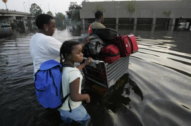
File photo above: “Nathaniel Dowl, 18, right, leads his mother Estelle Dowl and sister Cayla Dowl into the waters around the Superdome, Wednesday Aug. 31, 2005, in New Orleans, days after Hurricane Katrina hit the city.” (AP Photo/The Dallas Morning News, Michael Ainsworth)
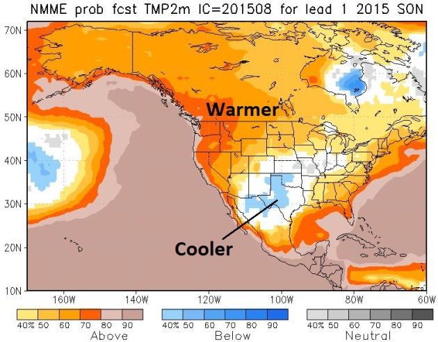
Extended Outlook: Odds Favor a Milder Fall. Thank (or blame) a Super El Nino for what appears to be a mild bias for much of the USA into November. The only exception: the southern Plains, where El Nino may energize the southern branch of the jet stream, resulting in cooler, wetter weather for parts of the southern USA. Source: NOAA Climate Prediction Center.
Hurricane Katrina In The New Yorker. Click here to see a rundown of stories from The New Yorker since Katrina struck 10 years ago; here’s an excerpt: “…A decade later, reliable information has emerged; so have many stories of endurance and survival. As a result, many of the New Yorker pieces collected here have a dual aim. They aim to tell the story of the storm as it was experienced by those caught up in it; they also try to answer, in an analytical way, the question of “societal fault.” The term “natural disaster,” Jelani Cobb wrote last week, can function as a “a linguistic diversion, one that carries a hint of absolution. Hurricanes, earthquakes, and floods are natural phenomena; disasters, however, are often the work of humankind.” In exploring Katrina and its aftermath, these writers have tried not to be diverted from the ways in which it was the most human of hurricanes...” (Katrina file image: NOAA).
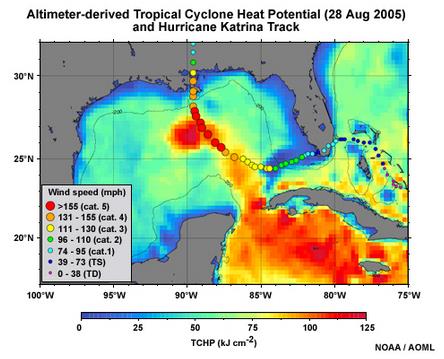
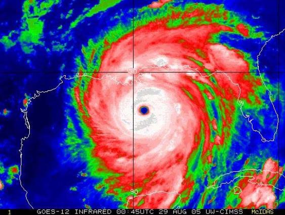
10 Years After Katrina: The Science Behind The Most Damaging Hurricane in U.S. History. Tropical weather expert Brian McNoldy has a very good explanation at Capital Weather Gang; here’s an excerpt: “…The very warm ocean eddy that Katrina tracked over in the central Gulf was associated with the Loop Current which transports warm Caribbean water northward towards the Gulf of Mexico and Florida Keys. As you can see from the track, it intensified as it passed over the high ocean heat content region, and began to weaken once it exited that region. Vertical shear was quite low throughout Katrina’s lifetime. On August 28, when Katrina was at its peak intensity, vertical shear throughout most of the Gulf of Mexico was below 12 mph (10 knots)...”

Katrina Landfall. NOAA NCDC has a great animation of the dynamics involved with Hurricane Katrina as it made landfall; here’s an explainer of the graphic above: “A 3-D animated image of downscaled Global Forecast System (GFS) model data showing Hurricane Katrina making landfall on August 29, 2005. This image was generated with the Visualization and Analysis Platform for Ocean, Atmosphere, and Solar Researchers (VAPOR) tool and ImageMagick.”
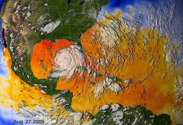
10 Years Later: Was Warming To Blame for Katrina? Water temperatures in the Gulf of Mexico were close to 90F as Katrina came ashore, adding additional fuel to the hurricane’s massive heat-engine. But was it triggered by warming? Here’s an excerpt from Climate Central: “…Unlike temperature records, which tend to extend back long enough to show how the odds of heat waves have changed over time — and whether those changes are beyond the normal chaotic ups and downs of nature — reliable hurricane records extend back at most a few decades to the beginning of satellite observations. That isn’t long enough for scientists to say with confidence that any changes to hurricane frequency or intensity over that time aren’t from natural variability alone. In fact, some work has shown that any expected trends in increased hurricane intensity may not be detectable for several decades...” (Image credit: NASA).
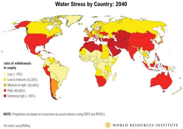
Ranking The World’s Most Water-Stressed Countries. World Resources Institute has the research referenced in the story above; more perspective and details: “…Using an ensemble of climate models and socioeconomic scenarios, WRI scored and ranked future water stress—a measure of competition and depletion of surface water—in 167 countries by 2020, 2030, and 2040. We found that 33 countries face extremely high water stress in 2040 (see the full list). We also found that Chile, Estonia, Namibia, and Botswana could face an especially significant increase in water stress by 2040. This means that businesses, farms, and communities in these countries in particular may be more vulnerable to scarcity than they are today...”

How Tesla Will Change The World. If you haven’t had a chance to read Tim Urban’s 3 part series on energy at Wait But Why carve out some extra time. It’s slightly irreverent, but information-rich with great illustrations and animations that help to explain why we are where we are; still stuck with 200-year old technology to power our vehicles and utilities. Here’s an excerpt from Chapter 2: “…If electric motors were the more advanced technology—if they were considered ideal because they were quiet, clean, and took advantage of cutting edge technology—why did the world give up on them? In 1900, neither electric nor gas cars were viable for mass adoption—both needed a few key technological breakthroughs. The key breakthroughs needed for gas cars happened first—but why was that reason for us to just settle, permanently, for the more primitive technology and the one that, over time, would make our cities smoggy and change the chemical makeup of our atmosphere? If 20th-century human invention could go from the Wright Brothers’ 12-second flight to the moon in just 66 years, surely advancing battery technology enough to bring electric car prices and charging times down while increasing range shouldn’t have been beyond our scope. Why did innovation and progress in something as important to the world as car-powering technology just stop?…”


TODAY: Murky sunshine. More smoke. Winds: S 10-15. High: 83
SUNDAY NIGHT: Partly cloudy and mild. Low: 67
MONDAY: Sticky sun, feels like July. Dew point: 70. High: 89
TUESDAY: Partly sunny, still muggy. Wake-up: 68. High: 88
WEDNESDAY: Isolated T-shower, then hot sun. Wake-up: 70. High: 87
THURSDAY: Early thunder possible, then tropical sun. Wake-up: 70. High: 88
FRIDAY: Hot sun, feels like 95-98F. Wake-up: 72. High: 91
SATURDAY: Sweaty sun, late PM T-storms. Wake-up: 73. High: near 90
SUNDAY: Showers and T-showers, turning cooler. Wake-up: 69. High: 76
LABOR DAY: Partly sunny and pleasant – big drop in humidity. Dew point: 52. Wake-up: 58. High: 74
Climate Stories….


