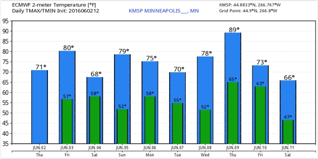
75 F. high temperature at KMSP Thursday.
74 F. average high on June 2.
76 F. high on June 2, 2015.
June 3, 1955: Seven people are killed on Lake Traverse when their boat is overturned by strong winds from a thunderstorm.
A Rarity So Far in 2016: Severe Risk Later Today
Do you feel like you’re being spammed by severe storm messages? Most meteorologists would much rather hear “you’re crying wolf!” than “there was no warning!”
We’ve come a long way since the first emergency sirens started wailing for severe weather back in the 50s. Nationwide the average lead time for tornado warnings is 13 minutes, up from 5 minutes in the 70s. Doppler radar has revolutionized the tracking and forecasting of severe local storms since the mid-90s. Fewer people than ever are being unnecessarily warned. At some point GPS-specific warnings will alert just the homes in the path of tornadoes and damaging wind and hailstorms (via smartphones and Smart TVs).
Stay tuned.
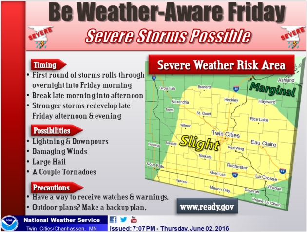
Although wind shear is marginal & low-level moisture minimal there may be just enough instability for a few severe storms later today. The primary risk is hail; a 15 percent chance of severe storms within 25 miles of any point.
Sunday looks like the nicer day of the weekend; a stray PM shower near Duluth and Spooner.
ECMWF guidance still hints at 90F next Thursday as summer returns with a vengeance.
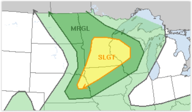
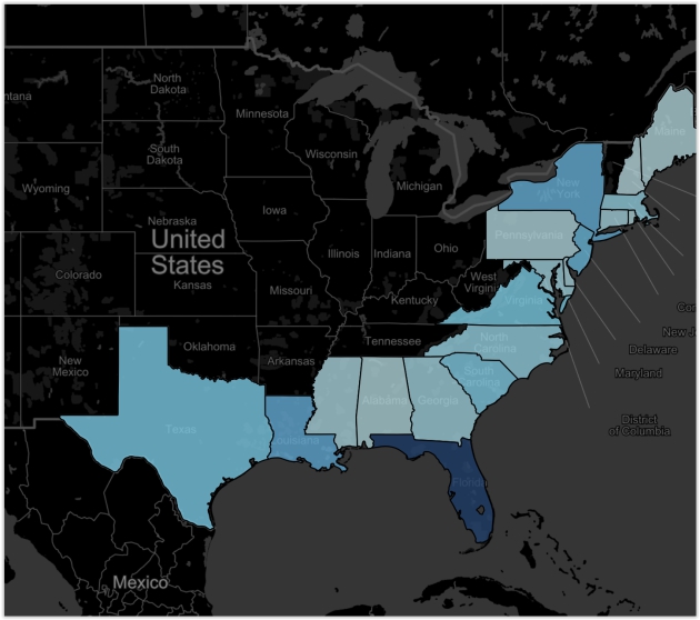
Slight Severe Storm Risk Today. NOAA SPC has a slight risk for central and southern Minnesota and most of western Wisconsin for a few storms capable of damaging hail and straight-line winds. A couple of tornadoes can’t be ruled out. The best chance of warnings: between 3 pm and 8 pm.
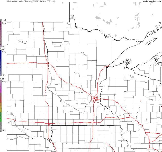
A Few Waves of Strong to Severe Storms Today. NOAA’s 4 KM NAM model pulls in light to moderate showers early this morning, a couple more bands of strong to potentially severe storms by late afternoon and evening. Guidance: AerisWeather.
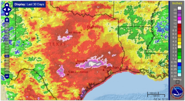
Record Flooding Continues To Mess With Texas. Once again weather has become stuck, with tragic consequences for Texas. Here’s an excerpt from WXshift: “…The big driver for this week’s round of rain has been a meandering area of low pressure in the upper atmosphere. This area of low pressure is cut off from the main jet stream flow, which has made its seasonal retreat northward toward the U.S.-Canada border. This leaves little movement in the atmosphere to push the system along, allowing it to repeatedly pour heavy rain as it draws in moisture from the western Gulf of Mexico. This system will eventually drift southward and fade away, but that will not happen until the end of the weekend, meaning that soggy conditions will linger through Sunday. Going into Thursday evening, an additional 2-4 inches of rain are forecast through the weekend in parts of central and eastern Texas…”
Map credit: “Last 30 days of rain, ending June 1.” Credit: NOAA.
Central Texas Floods: May – June 2016. Here’s an excerpt from Climate Signals: “Severe flooding from a large area of heavy rain that stalled across Texas at the end of May has taken at least six lives and caused historic river levels. The Brazos River in Richmond surged to hit 54.49 feet (16.6 meters)—its highest level in more than a century. This is the fifth major flood in the Houston area in 13 months. As the world warms, the air is able to hold and dump more water, which has led to a pronounced increase in intense rainfall events and an increase in flooding risk…”

Tropical Storm Colin Next Week? It’s still sketchy and borderline irresponsible drawing any conclusions from a 144 hour forecast, but a few runs of the GFS have spun up a possible tropical wave or even a tropical storm over the eastern Gulf of Mexico early next week with projected landfall near Tampa Tuesday morning. Something to keep an eye on. Map credit: WSI.
See How Much Florida Home Value is Threatened by Storm Surge. Here’s an excerpt from Real Time at the Palm Beach Post: “In the Miami-Fort Lauderdale-West Palm Beach metro area, CoreLogic counts 780,842 low-lying homes with a reconstruction value of $144 billion that are in danger of flooding during a storm. Of those houses, 75,903 are at “extreme” risk, meaning they could be inundated even by a Category 1 storm. One caveat: Those numbers have shifted significantly since last year, suggesting that estimating storm surge is an inexact science. In all 6.8 million homes worth $1.5 trillion are in the path of potential flooding from storms in the Atlantic and Gulf, CoreLogic says...”

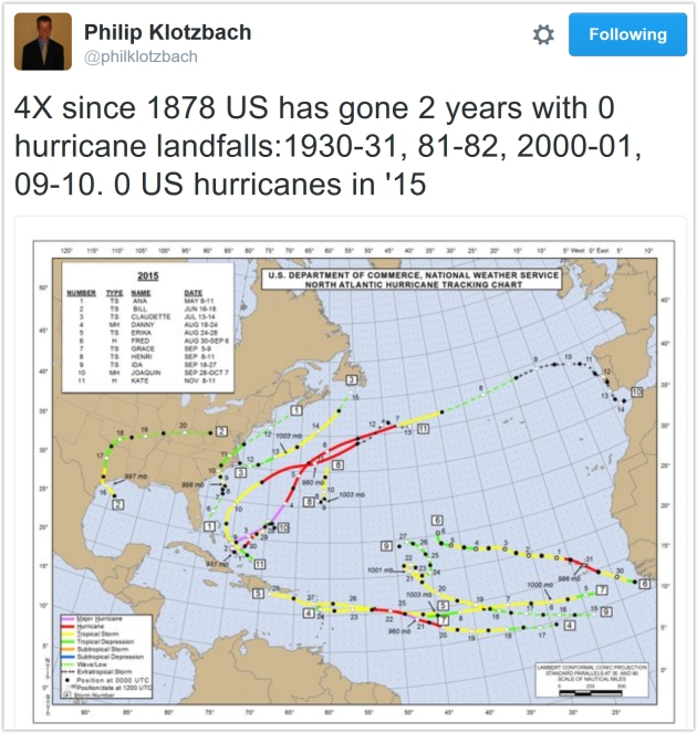
No Major U.S. Hurricane Landfalls in 9 Years: Luck? At some point the law of averages catches up with you, although I pretty sure I said something similar last year. And 2014. And 2013. Here’s an excerpt from NASA: “The United States hasn’t experienced the landfall of a Category 3 or larger hurricane in nine years – a string of years that’s likely to come along only once every 177 years, according to a new NASA study. The current nine-year “drought” is the longest period of time that has passed without a major hurricane making landfall in the U.S. since reliable records began in 1850, said Timothy Hall, a research scientist who studies hurricanes at NASA’s Goddard Institute for Space Studies, New York…”
Hurricane Ivan file image: NASA ISS.
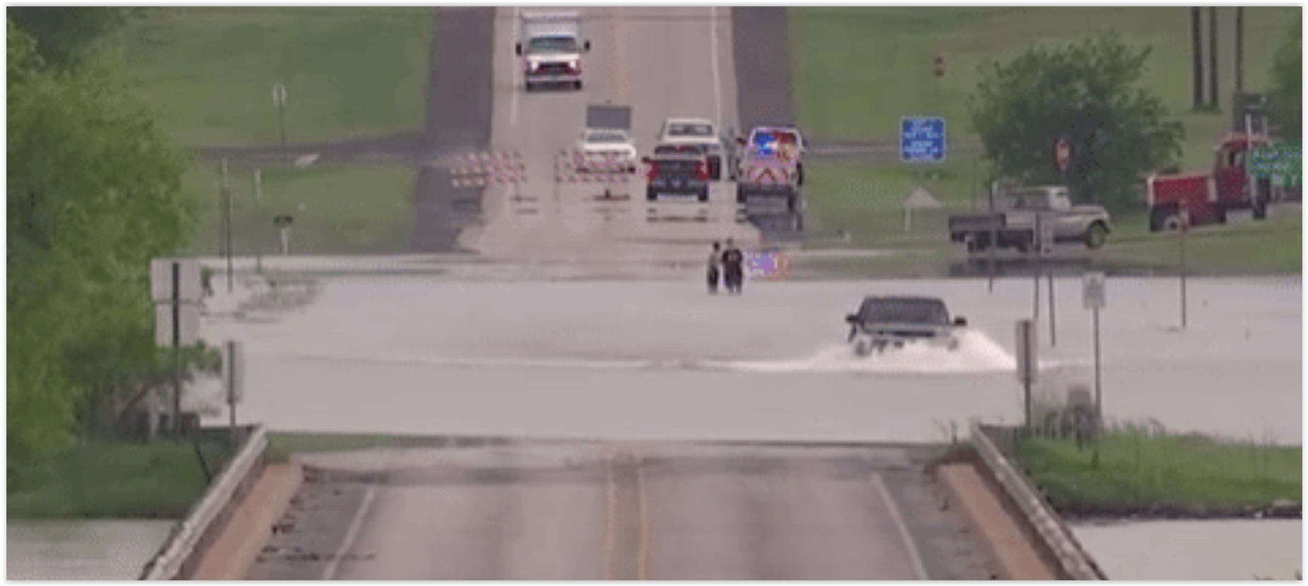
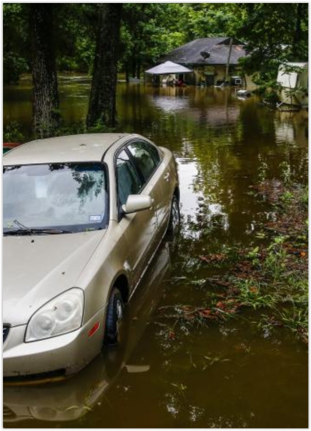
What To Do If You’re Driving And Encounter a Flash Flood. Rule #1 – don’t drive through high water – it’s impossible to estimate water depth, especially at night. Only 2 feet of moving water can turn your vehicle into a boat, with tragic consequences. NOAA has it right: “Turn around, don’t drown.” Here’s an excerpt from Popular Mechanics: “…Getting swept away while inside your vehicle is extremely dangerous. Although it sounds counterintuitive, if you’re stuck inside your car, you’ll want to roll down your windows and allow water to enter your vehicle. You can escape from your vehicle through the window or, if that’s not possible, wait until the water pressure is equal on both sides of your door so it will open...”

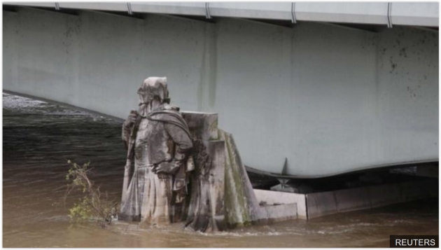
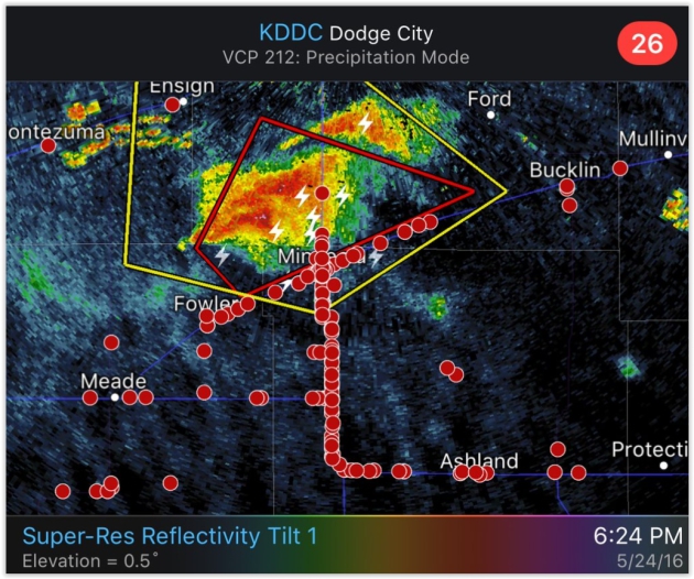
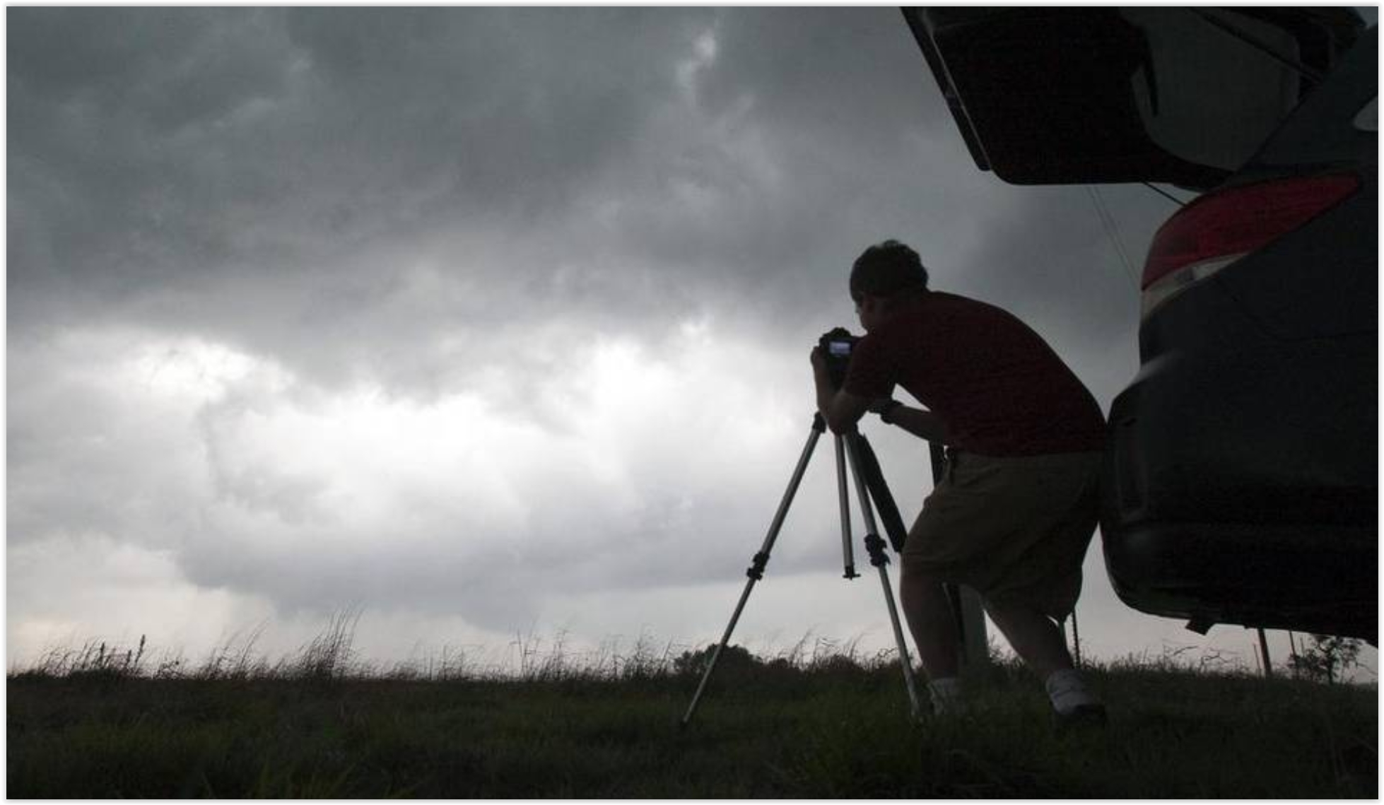
Photo credit: “A storm chaser photographs a rotating thunderstorm just east of Pretty Prairie, Kansas, April 14, 2012.” Travis Heying MCT.
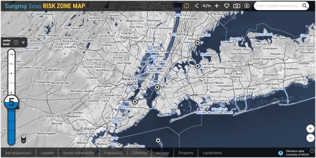
Rising Seas Could Swamp Crucial Infrastructure. Markeplace takes a look at the implications of a 2 foot rise vs. a 6 foot rise; here’s an excerpt: “…Nationwide, there is little coordinated planning or funding to deal with the threat posed to public infrastructure and private real estate by climate change and rising sea levels. “There are thousands of hazardous waste sites, chemical facilities that are on low-lying industrial land around the country,” said Ben Strauss at Climate Central. “And that is a huge concern.” Strauss is vice president for sea level and climate impacts at Climate Central, which has developed online mapping tools to show the potential effects of temperature and sea-level rise over the next century. Based on a projection of 2 feet in sea-level rise by 2100, Strauss said, “it is reasonable to imagine defending most coastal places with a couple of exceptions: some barrier islands, South Florida, parts of Louisiana. But with 6 feet, it becomes pretty much impossible to imagine—we see severe challenges to places like New York City or Boston…”
Surging Seas Risk Zone Map above courtesy of Climate Central.

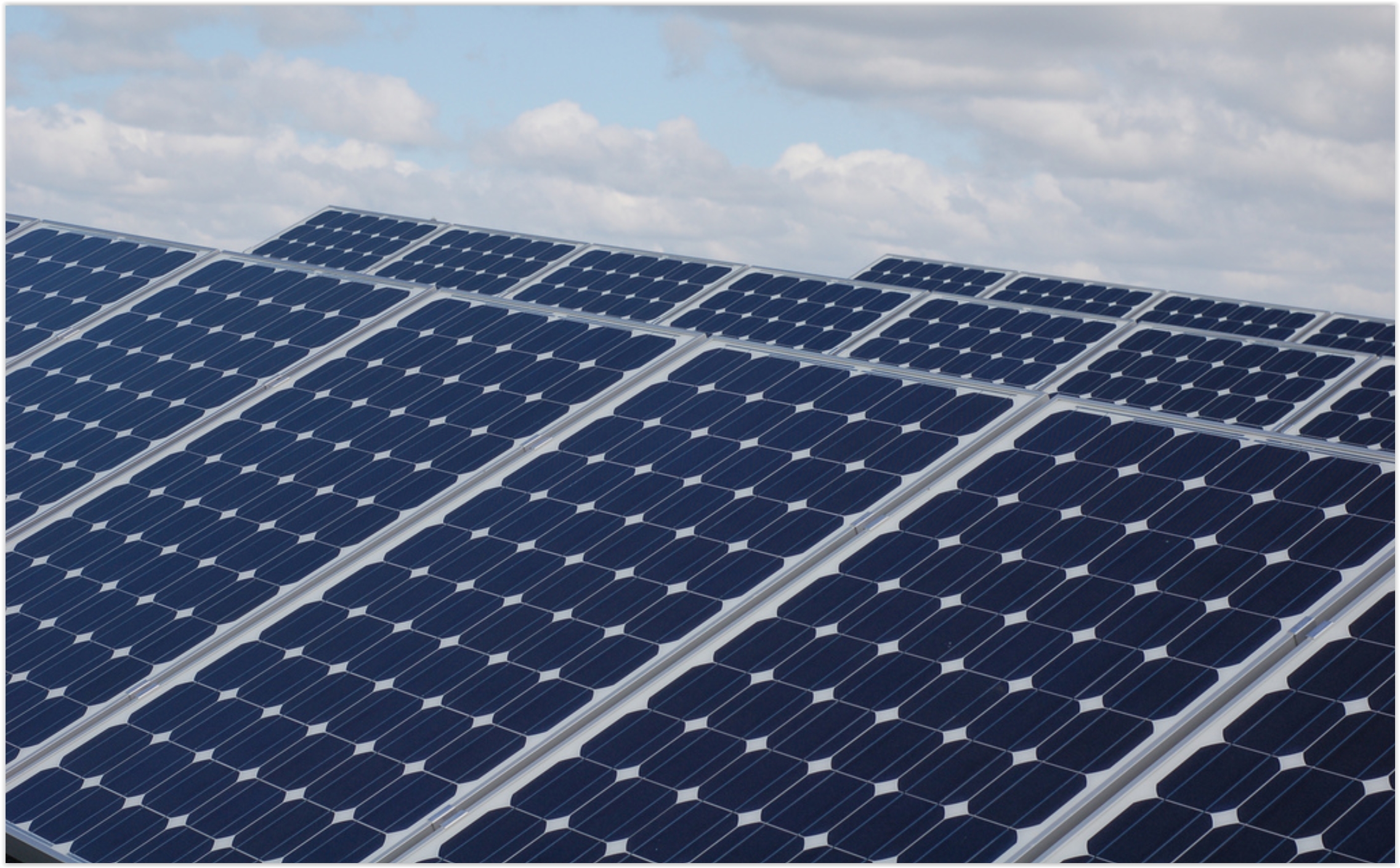
2016 Is A Breakthrough Year for Solar. TheHill has some encouraging statistics and projections: “Over the past few months, we’ve seen a rush of exciting developments in solar, some giving us insight into how distributed energy may work in the future. Thanks to tax credits (ITC) being renewed, 2016 will be a breakthrough year for U.S. solar, rising a stunning 119 percent. Sixteen gigawatts (GW) are expected to be installed, shattering last year’s record 7.3 GW, according to the Solar Energy Industries Association (SEIA) and GTM Research. In February, we passed a wonderful milestone as the millionth home was outfitted with a solar system. About 300,000 Americans will install solar this year...” (Photo: Utility Dive).
Critics: Minnesota Utility’s Solar Plan Pushes Out Competitors. Midwest Energy News has the story; here’s a clip: “…I think people are really excited about the opportunity to have more solar energy across Minnesota and in northern Minnesota,” she said. “There was a belief that community solar would add to the region’s economy.” However, if the program is owned solely by Minnesota Power, community solar may not have as great a potential as it would have in a more open process allowing other community solar developers into the mix, she argued. The group, calling itself the Northland Community Solar Coalition, includes churches, environmental organizations, clean energy groups and climate change activists such as Will Steger...”

Sun-Powered TV Opens $5 Trillion Frontier for Electronics Makers. A TV powered by solar power? Bloomberg has details: “…The Clean Energy Ministerial on Wednesday named a sun-powered TV made in Hong Kong as the top in its class after its manufacturer, Niwa Solar, more than doubled its energy savings over the 2012 competition winner. Clocking in with only 9 watts consumption, Niwa’s 15.6 inch screen needs just 2 percent of the power used by early color televisions and about a quarter of the juice that lights up a modern 20-inch flat panel.…” (Image credit: Niwa Solar).

Mary Meeker’s 2016 Internet Trends Report. Recode has a link to the full 213 slide PPT; here’s an excerpt that caught my eye: “…The home screen has acted as the de facto portal on mobile devices since the arrival of the iPhone and even before. Messaging apps, with context and time, have a chance to rival the home screen as the go-to place for interaction…”

Zen And The Art of Managing Smartphone Photos. The best camera is the one you have with you – all the time, right? But that can result in a blizzard of photos, most of them….meh. Here are some good tips at The New York Times: “…In other words, people need a photo-organization method that saves time — and that allows them to essentially throw out the need to sort and tag their enormous photo sprawl. So I tried several photo-management services and devices to determine what that method might be. Over a week, I tested three backup services with my iPhone photo library of about 8,000 images: Apple’s iCloud photo library, Dropbox and Google Photos, which automatically take your photos and store them in the cloud. I also tested two data backup devices from SanDisk and Synology…”
TODAY: Unsettled, few strong to severe T-storms. Winds: S 10-20. High: near 80
FRIDAY NIGHT: Few T-storms, locally heavy rain. Low: 60
SATURDAY: Periods of cool sunshine, stray PM shower. Winds: NW 10-20. High: 72
SUNDAY: Partly sunny, PM showers up north. Winds: NW 10-20. Wake-up: 55. High: 76
MONDAY: Fading sun, few PM showers. Winds: NW 10-15. Wake-up: 56. High: 73
TUESDAY: Brilliant sunshine, less wind. Winds: NW 8-13. Wake-up: 54. High: 72
WEDNESDAY: Partly sunny and warmer. Winds: S 10-15. Wake-up: 53. High: 79
THURSDAY: Hot, steamy sun, few T-storms. Winds: S 10-20. Wake-up: 63. High: near 90
Climate Stories…

U.S. Agriculture Secretary Thinks Farmers Can Help Solve Global Warming. Here’s the intro to a story at Scientific American: “Many large-scale farmers in the U.S. don’t care to hear much about climate change. Perhaps that is because agriculture—including livestock-rearing and forestry—is one of the largest sources of greenhouse gas pollution. Nevertheless, American farmers, ranchers and foresters have begun to adopt practices that could cut pollution, or so says a progress report from the U.S. Department of Agriculture on the “Building Blocks for Climate-Smart Agriculture and Forestry.…”
Photo credit: “From left, Secretary of Agriculture Tom Vilsack, and Sen. Jeanne Shaheen, D-N.H., holding a press conference at the Miles Smith Farm in Loudon, N.H., on Tuesday, Aug. 19, 2014.” Credit: Photo By Bill Clark/CQ Roll Call.

Risky Business Announces New Research. We have the solutions, the technology and innovators. Will we have the political will? Here’s an excerpt of an upcoming report from Risky Business: “…Ultimately, we want to know how American businesses can lead us towards an economy with lower climate risks. In conducting research for the new report, we will consider all practical solutions that contribute to lower carbon emissions. Nuclear energy, carbon-capture and storage, and a range of other commercial and near-commercial solutions are on the table alongside advanced energy storage, solar, and wind energy. Our report will synthesize recent analytical work on potential transitions to clean energy by time period, by sector, and by region. Researchers will analyze multiple investment and technical pathways across nine U.S. census regions...”
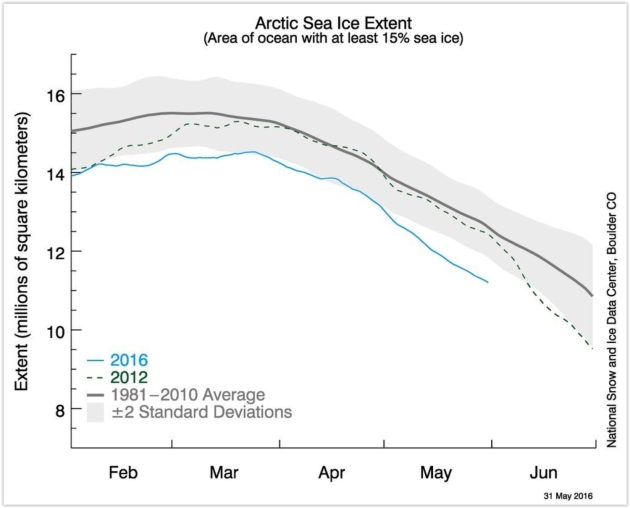
Arctic Sea Ice Set a Record Low Every Single Day in May. Here’s an excerpt of an update at Mashable: “After Arctic sea ice set a record low annual maximum in March, it was widely expected that this summer melt season would rank among the top 5 or 10 lowest melt seasons on record since the dawn of satellite observations there in 1979. However, even the most pessimistic projections have turned out to be too conservative so far, as pulses of unusually mild air and milder-than-average ocean temperatures have eroded the unusually thin sea ice cover from above and below…”
Graphic credit: “Sea ice extent through the end of May, with the blue line showing 2016.” Image: NSIDC
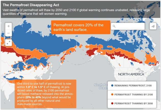
Melting Permafrost is Turbocharging Climate Change. Newsweek has the story; here’s an excerpt that caught my eye: “…Methane is an extraordinarily potent greenhouse gas, with up to 25 times the warming power of carbon dioxide.None of the permafrost thawing beneath millions of lakes across the Arctic is accounted for in global predictions about climate change—it’s “a gap in our climate modeling,” says Katey Walter Anthony, a University of Alaska Fairbanks researcher who studies permafrost thaw across Alaska and Siberia. She’s become famous in certain circles for finding methane bubbling up beneath the ice in frozen-over permafrost lakes, cutting a hole ice-fishing style and lighting the highly flammable gas on fire, sending up a column of flames 10 feet high….” (Map credit: Newsweek).


The “Temperature Spiral” Has an Update. It’s Not Pretty. This is one of the better visualizations I’ve ever seen about the warming underway – here’s an update from Climate Central: “…Like a lot of people, I found Ed Hawkins’ temperature animation very compelling because it details observed warming from 1850 to present in a novel way,” U.S. Geological Survey scientist Jay Alder said. “His graphic sets the context for looking at projections from climate models.” So Alder used climate projections and stretched the spiral to its logical conclusion in 2100 when most climate model projections end. Using our current carbon emissions trends, it shows that things could get out of hand pretty quickly...”
Animation credit: “An update to the famous temperature spiral using future climate projections.” Credit: Jay Alder/USGS.
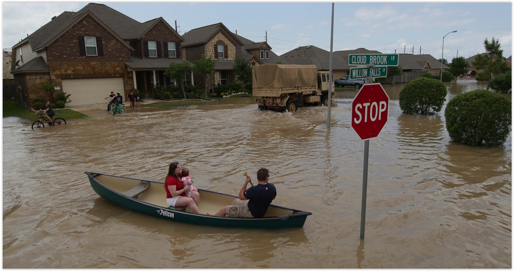
Houston Flooding is a Perfect Storm of Climate Change and Bad Urban Planning. Suddenly the “no zoning!” provisions seem like more of a bug than a feature, according to Grist: “…One likely cause,” Texas’ state climatologist John Nielsen-Gammon tells Grist, “is the increase in ocean temperatures from the Gulf of Mexico and tropical Atlantic. That determines how much moisture is in the atmosphere.” As temperatures increase, so does rainfall. But it’s not just the rainfall that is endangering Houston’s citizens — it’s also ecologically irresponsible development. Houston is the only major American city without formal zoning laws. As a result, developers have been free to pave over huge swaths of valuable wetlands that absorb runoff…”
Photo credit: U.S. Army National Guard/1st Lt. Zachary West/Handout via Reuters.

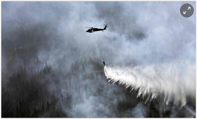
Spike in Alaska Wildfires is Worsening Global Warming, U.S. Says. Here’s the intro to a story at The Guardian: “The devastating rise in Alaska’s wildfires is making global warming even worse than scientists expected, US government researchers said on Wednesday. The sharp spike in Alaska’s wildfires, where more than 5 million acres burned last year, are destroying a main buffer against climate change: the carbon-rich boreal forests, tundra and permafrost that have served as an enormous carbon sink. Northern wildfires must now be recognised as a significant driver of climate change – and not just a side-effect, according to the report from the US Geological Survey…”
Photo credit: “A “Bambi Bucket” hanging from a helicopter releases hundreds of gallons of water on to the Stetson Creek Fire near Cooper Landing, Alaska, last year.” Photograph: Sgt Balinda O’Neal/AP.
