September 22, 1996: A brief cold air funnel touchdown results in roof damage in Washington County.
September 22, 1936: Summer-like heat continues with 101 at Ada, Beardsley and Moorhead.
Welcome Autumnal Equinox! Flash Flood Risk Lingers
August was the hottest on record, worldwide – the 16th “warmest month” in a row for the planet. That is unprecedented in 137 years of temperature observations.
Simmering warmth may push peak fall color viewing back a week or two this year. The Minnesota DNR reports vivid pockets of color from the St. Cloud area into the Red River Valley, but the North Shore is still mostly-green. Ample rains (no kidding) and a lack of drought-related tree stress should mean a very colorful October, statewide.
Autumn officially arrives today, but “Meteorological Autumn” really kicked off on September 1, marking the end of the warmest 90 days of the year.
Heavy showers and T-storms linger along a stalled frontal boundary into Friday. A Flash Flood Watch remains in effect; the best chance of gully-gushing, window-rattling storms over southern Minnesota.
The mercury may hit 80F Saturday with some sunshine before more storms flare up Saturday night. Don’t despair; skies clear on Sunday. Systems stall next week, a giant “cut-off” low pulling more rain into town by Tuesday.
Yeah, this is getting old.

Aeris Weather Briefing: Issued Wednesday, September 21st, 2016
- A slowly meandering/nearly stationary front across parts of the upper Midwest, combined with near record atmospheric moisture, will provide the set up for excessive rain across the region through Thursday.
- At least 2-5” of rain will fall across portions of Iowa, Minnesota and Wisconsin, with isolated higher amounts possible.
- This will lead to the potential of flash flooding in the region as well as rising lake and river levels. Flash Flood Watches are in place, including cities such as Sioux City and Waterloo (IA), the Twin Cities, Rochester and Mankato (MN), and Madison, Green Bay and La Crosse (WI).
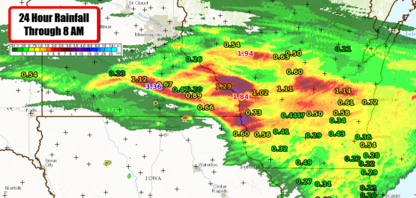
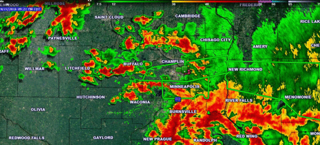
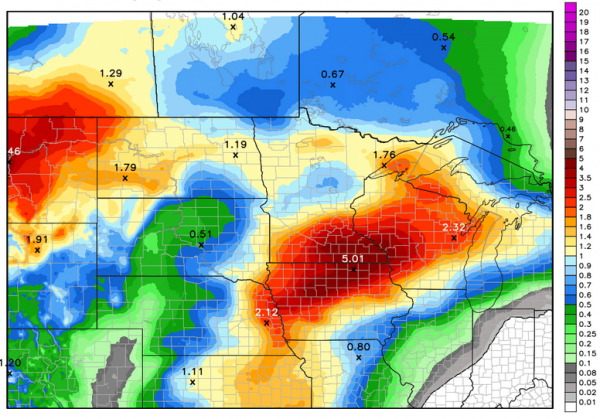
24 Hour Rainfall. The first round of storms moved across parts of southern Minnesota and Wisconsin last night, bringing many areas between 1-4” of rain. Over the last 24 hours, Waseca, MN picked up 3.36″ and La Crosse, WI received 1.84″ of rain. There were reports of water over driveways in Pickwick, MN, as well as mudslides northeast of town. Pickwick is located just southeast of Winona, MN.
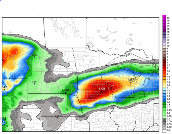
Forecast Rain Through Friday AM. While a nearly stationary boundary straddles the upper Midwest, a few waves of upper level energy will moves across the region. This will spark more rounds of showers and storms, likely leading to heavy rain totals. An additional 2-5” of rain can be expected through Friday morning across parts of southern Minnesota, western Wisconsin and northern Iowa. Some spots, especially where we get either slow moving storms or training storms (areas of heavy rain that move over the same region within a short amount of time), have the potential of picking up 7”+ of rain.
Graphic credit: WeatherBell.
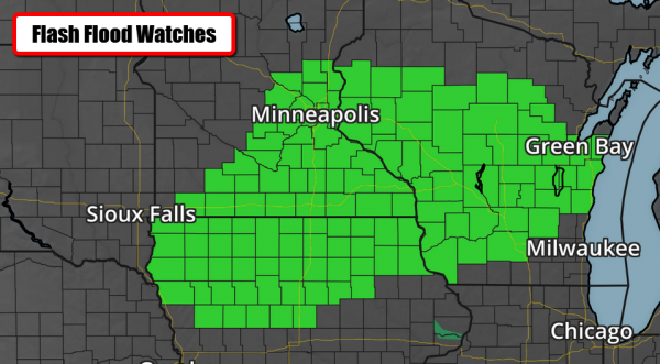
Flash Flood Watches. Flash Flood Watches are in place across parts of Iowa, Minnesota and Wisconsin due to the heavy rain threat over the next 48 hours. Again, the potential exists for at least 2-5” of rain across these areas. Graphic: Aeris Maps Platform (AMP).
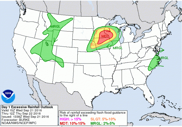
Flash Flooding Potential Today. We still expect some of the heaviest rain across the upper Midwest to fall today and tonight. Due to this, the Weather Prediction Center has outlined areas across parts of southern Minnesota, western Wisconsin, and northern Iowa under a “moderate” threat of excessive rainfall that could lead to flooding. Graphic: NOAA.
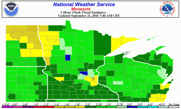
Three Hour Flash Flood Guidance. This product of the National Weather Service shows the average amount of rain that would need to fall over a certain county in a given time period for flash flooding to occur. Many areas over southern Minnesota as well as parts of southern/western Wisconsin and northern Iowa would need approximately 2” of rain within three hours for flash flooding to occur. Map: NOAA.
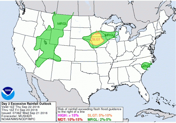
Flash Flooding Potential Thursday. The flash flood threat will continue on Thursday, with a “slight” risk of excessive rainfall that could lead to flooding across parts of Iowa and southern Minnesota.
Not The End Of The Rain. Another storm system will push out of the Rockies as we head into the weekend. This will absorb the stationary front, but bring with it another chance of 1-3” of rain across parts of the upper Midwest from Friday Night through next Monday morning, which could lead to more flooding.
Summary. The first round of heavy rain last night brought 1-4” of rain across parts of southern Minnesota and Wisconsin. More rounds of heavy rain are expected across the upper Midwest over the next couple days, with rainfall totals of at least 2-5”. Some areas of Iowa, Minnesota and Wisconsin where there are slow moving storms or training storms could pick up 7”+ of rain through Friday morning. Due to the excessive rain amounts, flash flooding can be expected across these areas, and Flash Flood Watches are in place. Facilities across these areas that normally experience problems during flash flood scenarios should be on alert for issues over the next few days.
D.J. Kayser, Meteorologist, AerisWeather
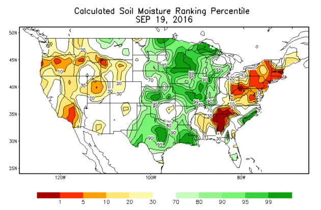
Soil Moisture: Off The Scale. Recent heavy rains have left the topsoil over much of central and southern Minnesota and western Wisconsin very wet; in the 99th percentile according to NOAA NCEP. The implications of this? Rain won’t be able to soak into the ground, but almost immediately run off into streets and streams, increasing the potential for flash flooding.
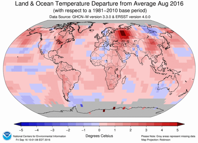
Earth Posts Hottest August on Record and 16th Straight Month of Unsurpassed Heat. Jason Samenow reports at Capital Weather Gang: “Record-breaking heat has never persisted on the planet for so long. Not only did Earth witness its hottest August on record, according to NOAA, but it also extended its streak of record-warm months to 16. Such a lengthy period of record-setting warmth is unprecedented in 137 years of temperature observation, NOAA said…“It is plausible that this summer was the warmest in thousands of years, perhaps even longer,” climate scientist Michael Mann of Penn State University told USA Today...”
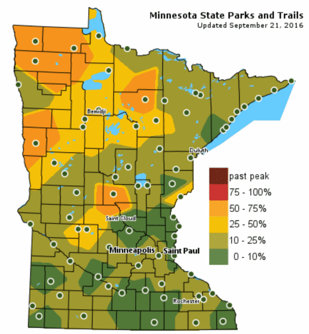
Delayed Color Up North. Is it due to our incredible wet spell or unusual warmth? Not exactly sure, but the latest Minnesota DNR Fall Color Report shows a fair amount of green lingering over the North Shore and Minnesota Arrowhead. There are pockets of intense color from the St. Cloud area into the Red River Valley.
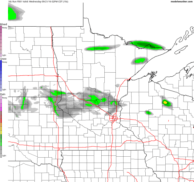
Heaviest T-storms Push South Today. We’re still in a wet pattern with a good chance of showers and a few T-showers today, but NOAA’s 4km NAM model shows last night’s troublesome frontal boundary pushing south of the metro; the greatest risk of storms across Iowa and southwestern Wisconsin. The front returns north as a warm front by Saturday, when afternoon temperatures may climb into the 80s. I know, what September? 60-hour Future Radar product: NOAA and AerisWeather.
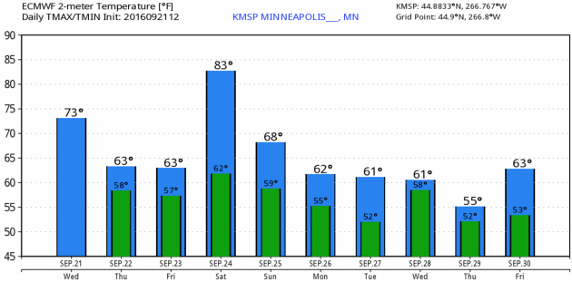
Trending Cooler (With a Few Exceptions). At some point gravity prevails, the tidal tug of shifting seasons – the fact that the sun angle is as high in the sky as it was on March 22. We’re due for a cool-down, and a transition to drier weather. I think I said something similar 2 months ago. ECMWF (European) predicted lows and highs for the Twin Cities above courtesy of WeatherBell.

Is Environmental Destruction a Crime Against Humanity? Here’s a snippet from The Washington Post: “This week, the International Criminal Court announced that it would give special consideration to pursuing crimes involving environmental destruction and land grabs. The announcement, made in a policy document released by the ICC’s prosecutor on Thursday, appeared to show a deliberate expansion in focus for The Hague-based court, which was established by the Rome Statute in 1998 to investigate war crimes and crimes against humanity when national governments were unable to do so…”
Photo credit: “Cambodian land rights activists shout slogans during a protest in front of the Phnom Penh municipal court on Aug. 22 to demand the release of two prominent activists who were sentenced to six days in jail.” (Tang Chhin Sothy/AFP).


This Harvard Professor Explains Why We Were Born to Resist Working Out. Here’s an excerpt from The Washington Post: “…But you can stop berating yourself now. You may just be giving in to humans’ evolutionary instinct to be lazy. At least that’s the theory of one Harvard professor who believes our ancestors exerted so much energy hunting and gathering that they sought rest whenever they could. We are predisposed to want to conserve energy. Daniel Lieberman, an expert in human evolutionary biology, posed in a 2015 paper, “Is Exercise Really Medicine? An Evolutionary Perspective,” that it’s not our natural inclination to exercise for health alone…”

The 20 Happiest States in the USA. Here’s an excerpt from Conde Nast Traveler: “There’s an ongoing debate about which U.S. city is friendliest: Savannah? Charleston? The saga continues. But what about the happiest states in America? The experts over at personal finance website WalletHub analyzed the 50 states and the District of Columbia across 28 key metrics of happiness, including emotional health, income level, social connectivity, and sports participation rates. Here’s what they found in terms of overall rank:
1. Utah
2. Minnesota
3. North Dakota
4. Hawaii
5. Colorado
FRIDAY: More showers, possible thunder – cool, damp breeze. Winds: E 10-15. High: 67
SATURDAY: Warm sunshine, T-storms arrive late. Winds: SE 10-20. Wake-up: 61. High: near 80
SUNDAY: Partly sunny, a drying breeze. Winds: W 8-13. Wake-up: 60. High: 71
MONDAY: Sunny start, then clouds increase. Winds: NW 7-12. Wake-up: 56. High: 66
TUESDAY: Another surge of rain moves in. Winds: N 10-20. Wake-up: 53. High: 65
WEDNESDAY: A foul sky: periods of rain and drizzle. Winds: SE 10-20. Wake-up: 54. High: 66
Climate Stories…

Here’s How Global Warming Could Trigger The Next Financial Crisis. Media hype? I sure hope so. Here’s an excerpt from Fortune: “Move over mortgages. There’s now something much, much bigger to worry about, and harder to curtail, and far more likely to cause the next financial crisis: global warming. That’s the conclusion of a new report published recently by the Bank of Canada. The report is mainly focused on the reinsurance industry, a shadowy corner of the insurance business, and the fact that what the last financial crisis showed us was that when insurance companies aren’t properly regulated or the risks they take on are poorly understood, the results can be disastrous…”

375 Top Scientists Warn of “Real, Serious, Immediate” Climate Threat. Here’s an excerpt of a Guardian article from Dr. John Abraham at St. Thomas University: “Yesterday, 375 of the world’s top scientists, including 30 Nobel Prize winners, published an open letter regarding climate change. In the letter, the scientists report that the evidence is clear: humans are causing climate change. We are now observing climate change and its affect across the globe. The seas are rising, the oceans are warming, the lower atmosphere is warming, the land is warming, ice is melting, rainfall patterns are changing and the ocean is becoming more acidic. These facts are incontrovertible. No reputable scientist disputes them. It is the truth. Despite these facts, the letter reports that the US presidential campaign has seen claims that the earth isn’t warming, or it is only a natural warming, or that climate change is a hoax…” (Image: NASA).

An Open Letter From Members of the National Academy of Science. 375 members of the NAS signed this letter yesterday; here’s an excerpt at responsiblescientists.org: “…The political system also has tipping points. Thus it is of great concern that the Republican nominee for President has advocated U.S. withdrawal from the Paris Accord. A “Parexit” would send a clear signal to the rest of the world: “The United States does not care about the global problem of human-caused climate change. You are on your own.” Such a decision would make it far more difficult to develop effective global strategies for mitigating and adapting to climate change. The consequences of opting out of the global community would be severe and long-lasting – for our planet’s climate and for the international credibility of the United States…”
Climate Disruption is Fueling Stronger Storms. Friend and colleague Jeff Masters is staring at the same weather maps I am; here’s an excerpt of an interview with PRI, Public Radio International: “I don’t recognize the climate anymore,” says Jeff Masters, the director of meteorology for Weather Underground. “I look at the weather maps in the morning, sometimes afraid of what I’m going to see. It’s just gotten so insane. The climate of the 20th century is gone. The climate I knew is not here anymore. We’re in an entirely new climate regime, and it is extremely intense.” Climate scientists have been reluctant to attribute any one storm to the effects of climate disruption, but this may soon start to change. After historic rains fell on parts of Louisiana — an estimated 7.1 trillion gallons, three times as much as Hurricane Katrina — NOAA published a report which said that climate change made the storm at least 40 percent more likely today than a hundred years ago…”
Is The Media Scaring the Public Too Much About Climate Change and Extreme Weather? Jason Samenow weighs in at Capital Weather Gang: “The media has gone overboard in calling attention to links between climate change and extreme weather, contend two scholars in the United Kingdom. They argue that journalists are oversimplifying connections between weather and global warming and are resorting to scare tactics that are distracting the society from being prepared for extreme weather. The hype is responsible for a counterproductive and paralyzing “atmosfear,” they claim. But their contention of a media-induced “atmosfear” goes too far. It’s possible to both plainly and carefully communicate how climate change is affecting extreme weather while also stressing the importance of extreme weather preparedness, irrespective of climate change…” (File image: Capital Weather Gang).
