86 F. high temperature in the Twin Cities Saturday.
83 F. average high on July 25, 2015.
81 F. high on July 25, 2014.
July 26, 1981: Chilly morning across northland with 33 degrees at Roseau and Wannaska.
An Irritating Smudge
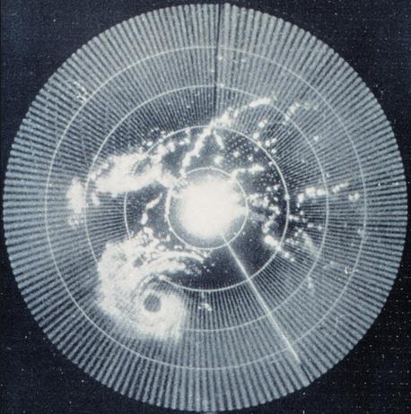
Radar technology gave the allied powers a distinct advantage during World War II. Tracking enemy planes and ships in real time provided a military edge. Around 1941 British radar operators noticed irritating smudges on their screens; interference that made it harder to pick out legitimate targets. It quickly dawned on them that they were witnessing rain shafts, and the race was on to perfect “Radio Detection And Ranging” or radar for short.
Today’s sophisticated “dual-polarization” Doppler radars not only see wind circulations within storms but can signal precipitation type, even detect clouds of debris thrown up by a tornado on the ground.
Satellites, transistors, the Internet, moon walks – you can make a strong argument that conflict is the mother of invention.
No weather drama today, although a few cumulonimbus may mushroom to life near the Iowa border. A surge of moisture from the Gulf of Mexico will cause the dreaded dew point to rise into the 70s Monday and Tuesday. If you factor low 90s each afternoon the heat index may top 100F both days. Something to look forward to.
Strong to severe T-storms Tuesday mark the leading edge of cooler, cleaner Canadian relief.
* File radar image above courtesy of Wikipedia.
Summer Temperatures, To Date. Temperatures have been average to slightly below average, as of July 23. Here are a few bullet points that caught my eye:
* According to my calculations, taking the average temperatures for the same period from 1981-2010 and averaging them, that average is 70.9°. So it would appear we are about on average.
* Two 90 degrees so far this summer.
Summer temperature data courtesy of AerisWeather meteorologist D.J. Kayer.
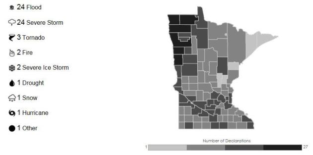
59 Weather-Related Disaster Declarations in Minnesota since 1953. It’s a dead heat between flooding and severe storms; ironic – based on our Nanook reputation – that only one disaster declaration was snow-related. 59 compares with 44 weather-related disaster declarations in Wisconsin, 59 in Iowa, 119 in Florida and 247 separate disaster declarations in Texas. The higher risk in the Red River Valley is a function of enhanced spring flooding risk. If only the Red River didn’t flow north. More details at FEMA.gov.
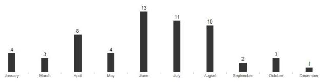
June: Peak Month for Weather-Related Disasters. This is consistent with other statistics I’ve seen for Minnesota; the atmosphere most unstable, volatile (and moist) in June, capable of supporting severe storms and tornadoes.
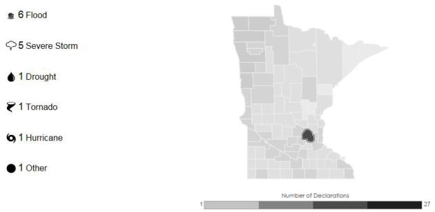
How Disaster-Prone Is Your County? Hennepin County has experienced 15 weather-related disaster declarations since 1953. Click here to drill down to Minnesota, then your home county.
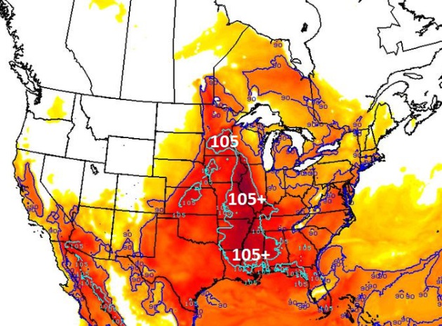
Beastly Hot Tuesday? Our internal models show a heat index approaching 105F by 4 PM Tuesday afternoon across much of central and southern Minnesota. Factoring in the projected dew point (mid to upper 70s) it may be the most uncomfortable day of 2015. Source: AerisWeather.
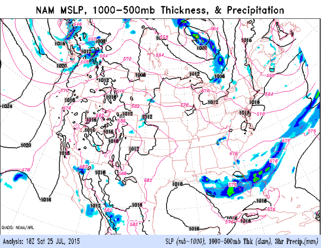
Heating Up – Then Some Midweek Relief. NOAA’s 12 KM NAM model going out 84 hours shows generally dry weather Sunday and Monday; a growing risk of strong ot severe T-storms Tuesday as cooler, drier air approaches. We should be breathing easier the latter half of the week.
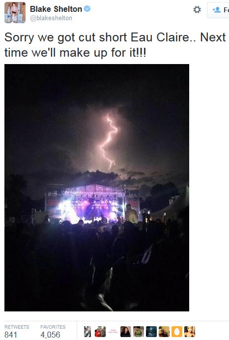
Close Call in Eau Claire. A friend of mine sent me more information about the Blake Shelton performance at Country Jam in Eau Claire Friday evening. This is still one of our worst-case scenarios, the kind of dilemma that keeps us up at night. Tens of thousands of people watching a concert or watching a sporting event – how do you move them all quickly and safely to shelter? In some cases it may not be possible. That’s why it’s good to have a radar app or two on your smartphone and keep an eye on it yourself. Don’t put your safety – or fate – into anyone else’s hands.
“Friday night was a close call with the weather. We took our daughter and a friend to Country Jam. By the time the headliner, Blake Shelton, took the stage, a storm was moving into Chippewa County to the north. It was quite the lightning show, but it looked like the storm would pass 15 miles to the north of the concert site. When a tornado warning was issued within the county, local emergency managers decided to shut down the concert and send approximately 25,000 home…”
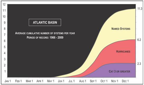
Why Haven’t We Seen Any Hurricanes This Year? Things may be heating up in the weeks to come; the peak of the season is the second week of September, historically. Here’s an excerpt at thedenverchannel.com: “…Just because there hasn’t been a named hurricane yet, and only three storms have been named doesn’t mean the season’s a complete wash. It’s just the opposite. Hurricane season begins on June 1, but it usually doesn’t start to ramp up until the beginning of August, and more often than not, into September…” (Image above: NHC).
How This El Nino Is And Isn’t Like 1997. Just like no two storms are identical no two El Nino warming phases are carbon copies. The stronger the warming signal in the Pacific, the greater the odds of a turn to wetter weather, even flooding for California by the winter months. Here’s a snippet of a good explainer at Climate Central: “…We think that the strength of [El Niño] is important,” L’Heureux said, but the exact strength it achieves is no guarantee of impacts similar to 1997, “and that’s simply because there’s other stuff going on,” she said. “El Niño is not the only ball game in town.” So where does that leave us in terms of looking ahead to what El Niño might bring this winter? We have an event that is looking more and more robust (when comparing June 2015 to June 1997, the broad ocean temperature patterns are very similar) and forecasting models are in pretty good agreement that that event will strengthen as we head towards winter and El Niño’s typical peak. But exactly when it will peak and what its final strength will be is still uncertain. Even more uncertain is what those other influences on U.S. weather will be…”
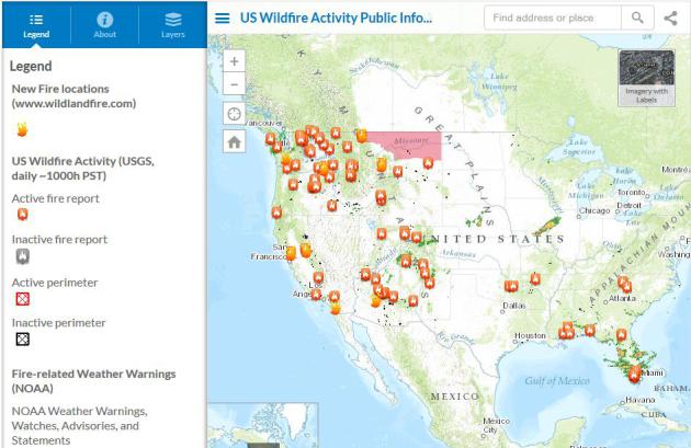
Scorched Earth: U.S. Wildfires Near Record Level. Here’s the introduction to a good summary at USA TODAY: “Wildfires have burned a phenomenal 5.5 million acres across the U.S. so far this year, an area equal to the size of New Jersey. This is the second-highest total in at least the past 25 years, according to data from the National Interagency Fire Center in Boise. Only 2011, which saw 5.8 million acres charred as of July 23 of that year, had more. On average, at this point in the year, 3.5 million acres would have burned...” (Map credit above: ESRI).
Rare Tornado Hits Northern Sweden. No injuries reported in northern Sweden; here’s an excerpt from The Local Sweden: “...It is now high season for tornadoes in Sweden, but it is difficult to say how many occur each year. Tornadoes are often short-lived, and therefore difficult to observe. “There are usually about a dozen tornadoes in Sweden each year”, says Camilla Albertsen, a meteorologist at the Norwegian Weather Service. “Powerful tornadoes in Scandinavia can lift rooftops or cars, but usually only topple a few trees…”

In The War of 2050, The Robots Call The Shots. Here’s the intro to a fascinating story at defenseone.com: “In April, thought leaders from the Defense Department, the U.S. Army Research Lab, the Institute for Defense Analysis, and national security thinkers across academia met for a two-work workshop on the next three and a half decades of war. The report they recently produced reads like a Tolkien-esque saga set in the future, a fascinating mashup of futuristic concepts, far-off capabilities, and emergent technologies that play off one another, competing and evolving at hyperspeed. Among the report’s most significant conclusions: faster “battle rhythm” will increasingly push human beings out of the decision-making loop. The future of war belongs to the bots...”
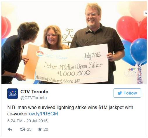
Canadian Lightning Strike Survivor Wins Lotto. No way. CTV News and TIME have the mind-boggling details; here’s the intro: “The odds that Peter McCathie would be struck by lightning and win the lotto are approximately 1 in 2.6 trillion Peter McCathie quite literally defied the odds. The Canadian man, who was previously struck by lightning when he was 14, collected his Atlantic Lottery winnings on Monday...”

TODAY: Sticky sunshine, isolated T-shower. Winds: SE 8. High: 87
SUNDAY NIGHT: Warm and muggy – stray thunder. Low: 72
MONDAY: Partly sunny. Feels like 95-100F. High: near 90
TUESDAY: Some sun, sweltering. Few severe storms? Feels like 100F. Wake-up: 74. High: 92
WEDNESDAY: Sunny, turning less humid. Wake-up: 69. High: 87
THURSDAY: Plenty of sun, quite pleasant. Wake-up: 65. High: 85
FRIDAY: Warm sunshine, hit the road early. Wake-up: 66. High: 86
SATURDAY: Sunny start, late-day T-storms? Wake-up: 68. High: 88
Climate Stories….
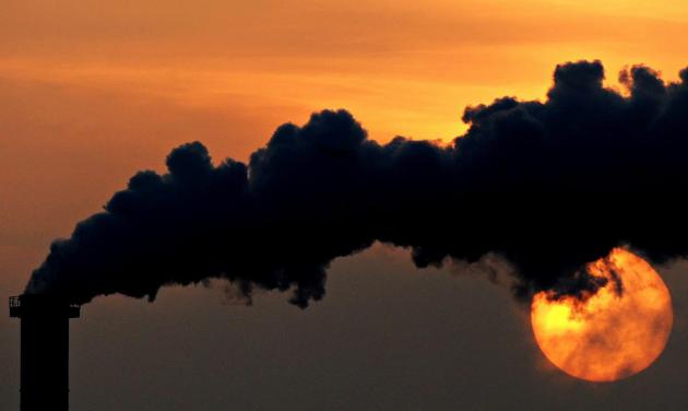
Investors Could Lose $4.2 Trillion Because of Climate Change, Report Warns. Here’s the intro to a story at The Guardian: “Private investors stand to lose $4.2tn (£2.7tn) on the value of their holdings from the impact of climate change by 2100 even if global warming is held at plus 2C, a report from the Economist Intelligence Unit (EIU) has warned. If firm action is not taken at the forthcoming climate change talks in Paris and the Earth’s temperature warms by a further 5C then investors are facing losses of almost $7tn at today’s prices, new research shows…”
Photo credit above: “The future is grim for private holdings in fossil fuel companies over action – or inaction – around climate change.” Photograph: Daniel Reinhardt/EPA.

Jeb Bush Calls for End To Fossil Fuel Subsidies. Here’s a clip from an update at NationalJournal: “eb Bush wants to get rid of tax credits for the oil and gas industry. “I think we should phase out, through tax reform, the tax credits for wind, for solar, for the oil and gas sector, for all that stuff,” the 2016 Republican candidate said in New Hampshire on Wednesday, according to a video recorded by grassroots environmental group 350 Action...”
July 23 photo credit: Ian Thomas Jansen-Lonnquist/The New York Times.

Navy Climate Change Expert Sees Opponents Ignoring Science. I know Admiral Titley – he’s a friend, classmate and colleague, and he’s right. This is no longer about science and facts. Here’s an excerpt from Times Union: “…Climate deniers who claim that thousands of scientists are engaging in a global fraud are “one step way from a conspiracy theory” that is too fantastical to be even feasible, he added. “Think about it. We have an administration that could not roll out a proper health care website. You think they can manage a global scientific conspiracy? They could not do it if they wanted to,” said Titley, who also holds a doctorate in meteorology. And he scoffed at the idea that scientists are deliberately lying about climate change just to obtain short-term research grants. When he headed the Navy’s climate change task force, the group looked at issues like rising sea levels, which is one outcome of global warming. Naval bases around the world will be affected and planners have to be ready for it, he said…”
Photo credit above: “Rear Admiral David Titley tours the USS Slater in Albany, N.Y. April 26, 2012, as part of the United States Navy’s 50/50 Program, an outreach effort that features 50 senior Navy leaders in 50 U.S. cities.” (Skip Dickstein/Times Union archive)
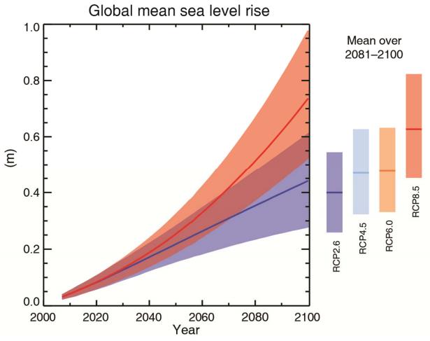
A New Climate Change Danger-Zone? Elizabeth Kolbert takes a look at the recent fuss over climate scientist James Hansen’s latest research on the rate of Antarctic ice and the level of risk posed to coastal cities. Here’s an excerpt at The New Yorker: “…In a paper set to appear online this week in Atmospheric Chemistry and Physics, the modellers, led by James Hansen, the former director of NASA’s Goddard Institute for Space Studies, warn that an increase of two degrees Celsius could still be enough to melt large portions of Antarctica, which, in turn, could result in several metres’ worth of sea-level rise in a matter of decades. What’s important about the paper from a layperson’s perspective—besides the fate of the world’s major coastal cities, many of which would be swamped if the oceans rose that high—is that it shows just how far from resolved, scientifically speaking, the question of danger levels remains. And this has important political implications, though it seems doubtful that politicians will heed them...”
