82 F. high in the Twin Cities Sunday.
67 F. average high on September 27.
83 F. high on September 27, 2014.
September 28, 1983: Late summer with 91 degrees at Montevideo and 90 degrees at Elbow Lake.
September 28, 1895: “Furious wind” at Pleasant Mound in Blue Earth County blew down grain stacks and corn shocks. Source: Twin Cities National Weather Service.

Minor Correction
Feels Like Autumn This Week
“Delicious autumn! My very soul is wedded to it, and if I were a bird I would fly about the earth seeking the successive autumns” wrote George Eliot. Amen. But is it autumn yet? The calendar says so, but the jungle-like canopy of green outside my window is a reminder that fall is running late this year.
September temperatures are averaging more than 6F warmer than usual, but Canada pops our warm weather bubble this week. We’ll have to be content with 60s, closer to average.
On average the metro sees the first frost of the season the first week of October, but I don’t see any jolts of freezing air looking out 2 weeks or so. Today’s weather will help you focus on work or errands: more clouds, a few passing showers as cooler air dribbles south of the border.
Dust off a sweatshirt or light jacket for Tuesday morning, but faint whiffs of summery warmth will return in October. No big storms are brewing close to home; ECMWF guidance hinting at the next chance of rain one week from today.
With this week’s cool front maybe the leaves will start to turn. Cue the color. It’s time!
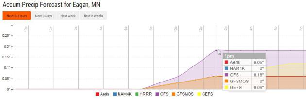
Showery Morning? Models suggest the best chance of showers will come during the morning and midday hours, maybe a tenth of an inch or so as cooler air pushes into Minnesota. Source: Aeris Enterprise.
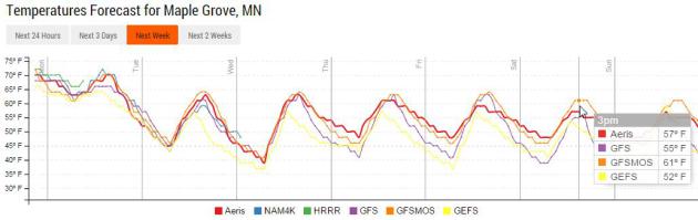
Cooler, But Hardly Controversial. No Canadian slaps yet, just a minor reality check as temperatures drop closer to average for late September. Today will be the mildest day; highs mostly in the 60s from Tuesday into the weekend.
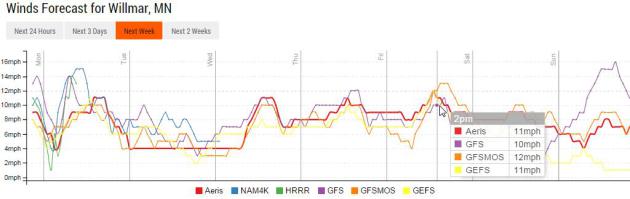
Wind Prediction. A stiff north breeze at 10-15 mph will drop temperatures today; winds are forecast to ease up a bit Tuesday before picking up again by late week. Graphic: Aeris Enterprise.
Accumulated Rainfall. Here’s how much rain NOAA’s NAM model is printing out between now and Thursday at 1 AM; soaking rains for the Florida Panhandle and much of New England – as much as 3-4″ of rain possible over the next 72 hours. Source: Aeris Weather.
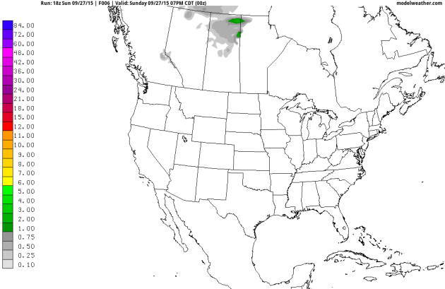
Accumulated Snow. No slushy shockers shaping up yet, although a few inches of snow may coat the higher peaks of the Rockies by early next week. I’m in no great hurry, by the way, although my friends with snowmobiles are already chomping at the bit. GFS guidance through early Wednesday, October 7, courtesy of NOAA. Animation: Aeris Weather.

How a Little Lab in West Virginia Caught Volkswagen’s Big Cheat. As one of the comments at the bottom of the article said: “A guy in WV takes down VW on a test commissioned by a guy named German. Some things were just meant to be.” NPR has the story; here’s an excerpt: “Volkswagen was recently brought to its knees when scientists discovered the company had installed a device in its diesel-powered cars to fool emissions tests. Its stock price tanked, its reputation has been damaged and its CEO resigned on Wednesday. So who made the discovery that sent the German car giant into a tailspin? A group of scientists at West Virginia University…”
Photo credit above: “Diesel car engines like this one in a 2012 Volkswagen Golf are among those that include software that circumvents EPA emissions standards for certain air pollutants.” Patrick Pleul/DPA/Landov.
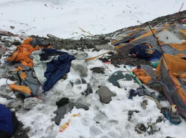
I Survived the Deadliest Day in Everest’s History, and I’m Still Surviving It. Here’s an excerpt of a harrowing first-person account of a very bad day on Mt. Everest at Quartz: “…It wasn’t the kind of avalanche I’d seen footage of in documentaries, a billowy white plume traveling down a mountain’s face. This looked more like a tsunami—the unrealistic kind of tsunami you see only in Hollywood movies. It looked as if it was rising from the ridge and would barely touch the actual slopes of Pumori, instead hurtling through the air to a farther destination: us. Then Fhinju and Suber started running. I took one last glance at the apocalyptic cloud and turned on my heels to run with them. We didn’t get far. I myself hadn’t taken two steps when I tripped and fell flat on my face.…”
What Happens Next Will Amaze You. And possibly horrify you as well. Privacy on the Internet, being tracked by advertisers, worshipping a tech-elite while poverty and homelessness runs rampant. Check out a transcript of a recent presentation by Maciej Ceglowski at a tech conference in Copenhagen, Denmark; here’s an excerpt: “…Today we live in a Blade Runner world, with ad robots posing as people, and Deckard-like figures trying to expose them by digging ever deeper into our browsers, implementing Voight-Kampff machines in Javascript to decide who is human. We’re the ones caught in the middle. The ad networks’ name for this robotic deception is ‘ad fraud’ or ‘click fraud’. (Advertisers like to use moralizing language when their money starts to flow in the wrong direction. Tricking people into watching ads is good; being tricked into showing ads to automated traffic is evil.)…”

TODAY: Clouds, few showers. Winds: N 10-15. High: 71 (falling)
MONDAY NIGHT: Partly cloudy and cooler. Low: 49
TUESDAY: Cool, blue sky – feels like fall. Winds: N 7-12. High: 64
WEDNESDAY: Partly sunny, seasonable. Wake-up: 45. High: 65
THURSDAY: Mix of clouds and sun. Wake-up: 47. High: 66
FRIDAY: Some sun, probably dry. Wake-up: 49. High: 65
SATURDAY: Partly sunny, still quiet. Wake-up: 48. High: 63
SUNDAY: Intervals of sunshine. Wake-up: 48. High: 64
Climate Stories….
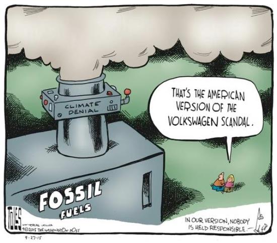
Cartoon courtesy of Tom Toles at the Washington Post.
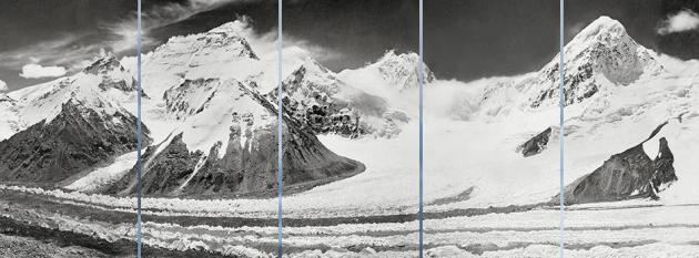
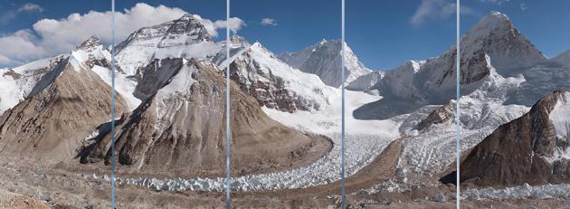
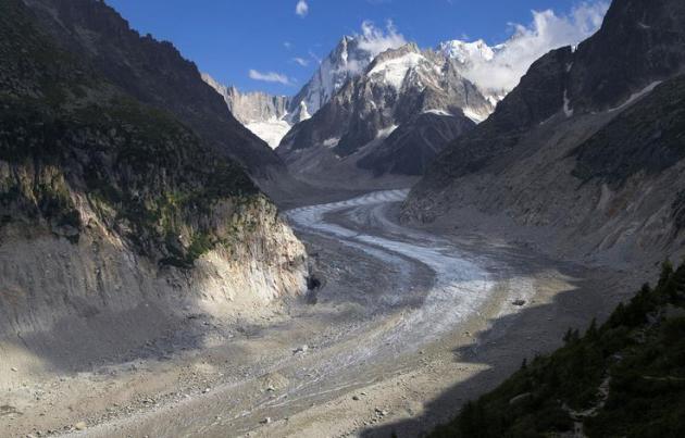
The Mighty Himalayan Glaciers are Melting. Check out the details at GlacierWorks: “The snow and ice stored within this resplendent arc of nearly 50,000 high-altitude glaciers are vital sources of water for the major rivers of Asia. GlacierWorks is a non-profit organization that vividly illustrates the changes to Himalayan glaciers through art, science, and adventure.”
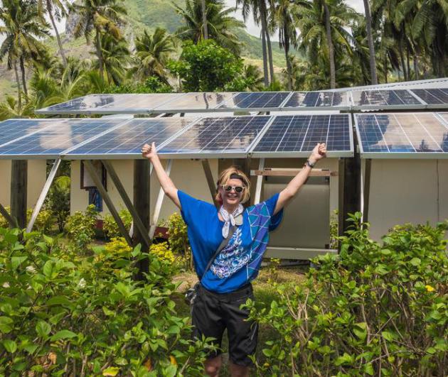
Microsoft Leads Movement to Offset Emissions With Internal Carbon Tax. Forward-thinking companies are already ahead of the curve; here’s an excerpt from The New York Times: “When Microsoft business unit managers calculate their profits or losses each quarter, they consider more than just sales and expenses. They also factor in the price of carbon. Even more radically, the business units are charged an internal tax by Microsoft based on their energy usage. The money goes into a common fund that invests in environmental sustainability projects. The company’s program is at the forefront of a fast-growing effort called carbon pricing…”
Photo credit: “Tamara DiCaprio, senior director of environmental sustainability at Microsoft, with solar panels in French Polynesia.”
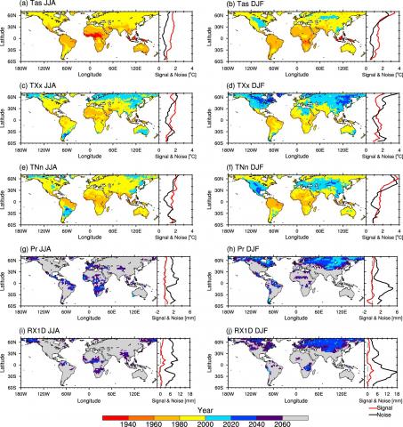
Researchers Reveal When Global Warming First Appeared. Here’s an excerpt of an interesting story at reportingclimatescience.com: “…Remarkably our research shows that you could already see clear signs of global warming in the tropics by the 1960s but in parts of Australia, South East Asia and Africa it was visible as early as the 1940s.” The reason the first changes in average temperature and temperature extremes appeared in the tropics was because those regions generally experienced a much narrower range of temperatures. This meant smaller shifts in the temperature record due to global warming were more easily seen. The first signal to appear in the tropics was the change in average temperatures. Later extreme temperature events showed a global warming signal…”
Map credit above: “Median time of anthropogenic emergence and zonally averaged signal and noise for climate means and extremes. Maps of median TAE averaged across 23 model simulations for (a) and (b) mean surface air temperature, (c) and (d) highest daily maximum temperature, (e) and (f) lowest daily minimum temperature, (g) and (h) total precipitation, and (i), (j) maximum 1-d precipitation for (a), (c), (e), (g) and (i) June–August and (b), (d), (f), (h) and (j) December–February. Zonally averaged values of signal (red) and noise (black) are shown where signal is the mean difference in the variable between 1989–2039 and 1860–1910, and noise is the standard deviation of the variable for 1860–1910.” Courtesy: University of New South Wales.
