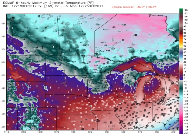
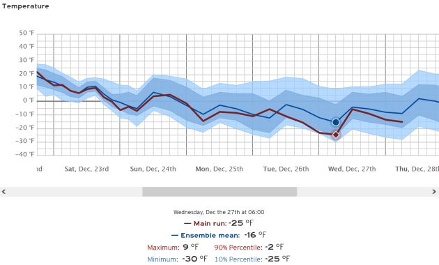
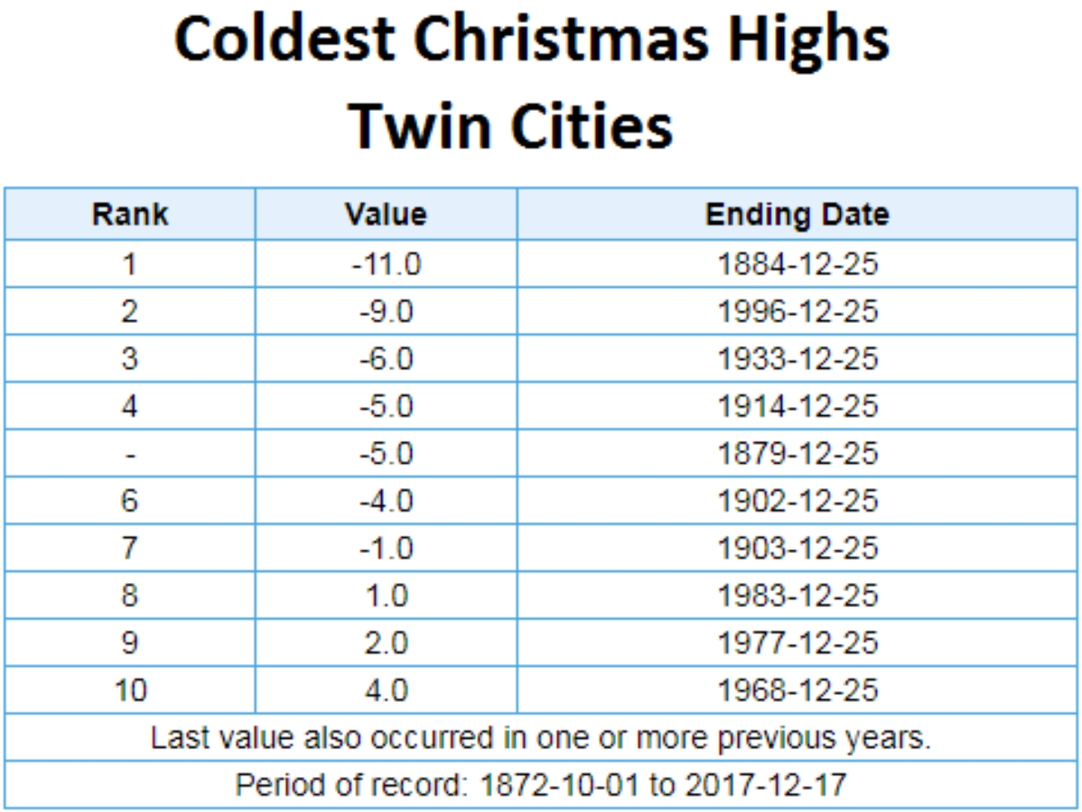
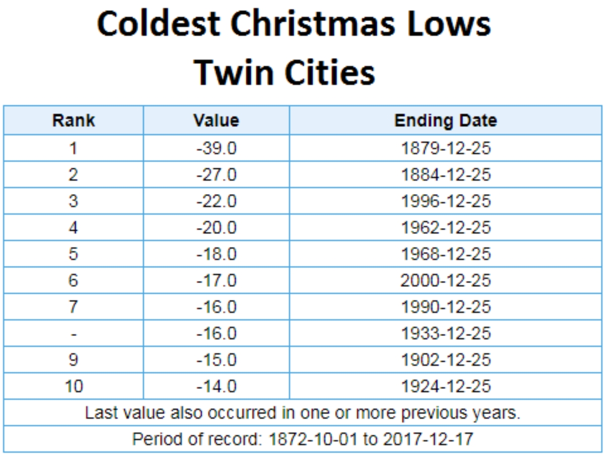
This will probably be the coldest Christmas since 1996, when we woke up to -22F in the Twin Cities (air temperature) with a “high” of -9F. Next week could be the coldest week of the entire winter, with a 4 day stretch of subzero weather
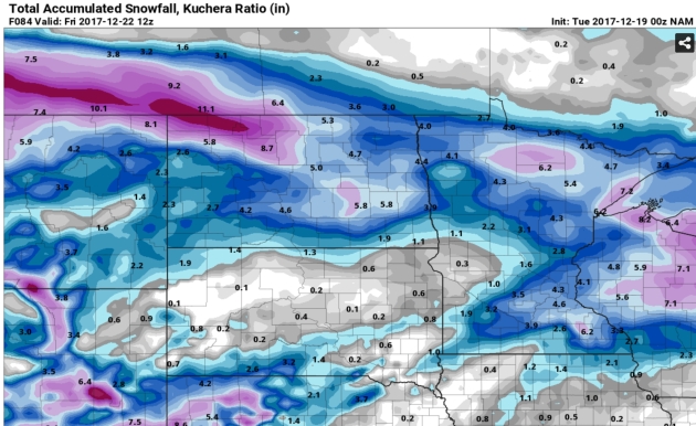
NAM Guidance. Last night’s 00z run of the 12km NAM from NOAA suggests 2-4″ of snow across most of central and southern Minnesota, with a bulls-eye close to 6″ near Rochester. It’s still a little early to be throwing around inch-amounts for a storm 36-48 hours away, but Thursday’s snow may be plowable for portions of Minnesota. Source: pivotalweather.com.

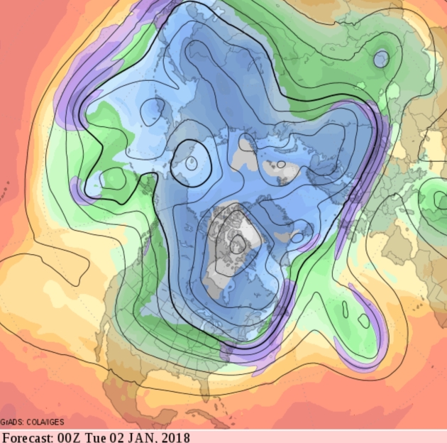
Numbing Start to 2018. I still don’t see any convincing evidence that the polar blast on tap for next week will linger for an extended period of time. It’s too early to say with any certainty whether this will be a repeat of 2013-2014, when “polar vortex” entered the popular lexicon. I don’t see the ridging over Greenland that would prolong subzero cold for month after month – at least not yet.
Fire Weather Conditions Slowly Ease Across SoCal. Praedictix Briefing: Issued Monday, December 18th, 2017
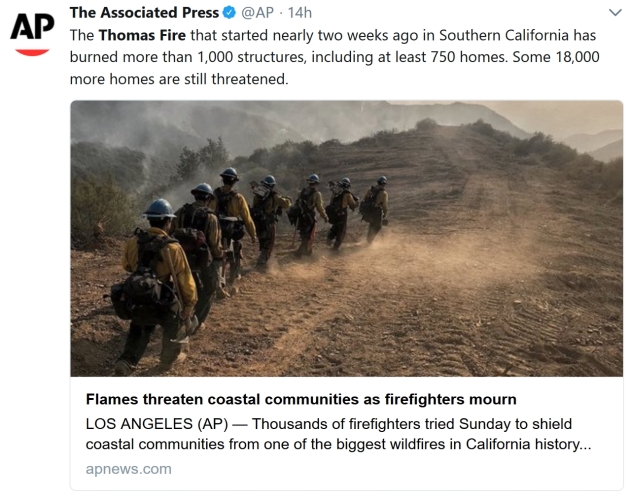
- The Thomas Fire, currently the third largest wildfire in California history, continues to burn northwest of Los Angeles Monday morning. The fire has burned 270,500 acres so far and is 45% contained. According to Cal Fire, the fire has cost more than $123.8 million so far, and containment isn’t expected until January 7th.
- While some evacuation orders were lifted across Ventura and Santa Barbara Counties Sunday, numerous mandatory evacuations remain in place – here are evacuation maps for Ventura County and for Santa Barbara County. According to KEYT-TV, Santa Barbara police are expecting mandatory evacuations to continue in town through at least Wednesday.
- Both Ventura County and Santa Barbara County are keeping their local government pages updated with evacuation orders, road closures, and other relevant information like evacuation shelters.
- Elevated fire danger continues through the morning hours today across southern California before winds weaken by the afternoon. Winds will remain light through Tuesday, with even some onshore flow. By late Wednesday, gusty northerly winds are expected to return through at least Thursday.

Thomas Fire Update. The Thomas Fire has grown to 270,500 acres burned and is 45% contained as of Monday morning. This ranks as the third largest wildfire in California history, and is quickly approaching the largest on record (the Cedar Fire back in October 2003, which burned 273,246 acres). The map above is the area that has been burned by the Thomas Fire. A closer look at this map can be viewed at Inciweb.

Elevated Fire Danger Today. Elevated fire weather continues this morning across southern California before gusty winds weaken in the midday to afternoon hours. Map: AerisWeather.

Wind Advisories In Effect. Wind Advisories continue to be in effect through 9 AM for parts of Ventura and Los Angeles Counties, as winds will gust to 45 mph out of the northeast at times. These gusty winds will start to diminish into the afternoon hours.

Los Angeles Area Wind Gusts Tuesday. We will see weaker winds across the Los Angeles region on Tuesday, with onshore winds and gusts primarily under 15 mph.

Los Angeles Area Wind Gusts Wednesday. A frontal system will move through during the second half of the day Wednesday, bringing back gusty northerly winds to the Los Angeles area. These strong winds will continue through Thursday. High pressure will linger in the Great Basin as well toward the end of the week, keeping the potential of strong northeast winds around across southern California through at least Friday. These stronger winds will once again bring fire weather concerns from Santa Barbara southward to San Diego for the middle and end of the week as conditions continue to remain fairly dry.
Meteorologist D.J. Kayser, Praedictix
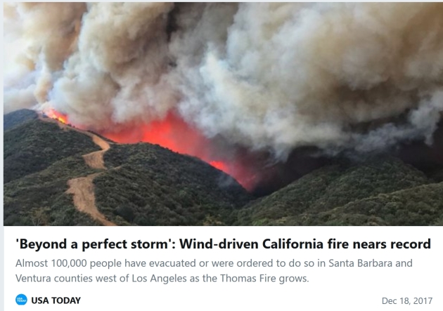
WILDFIRES: From Climate Nexus Hot News: “Thomas Fire on course to become California’s largest-ever wildfire (CNN), California wildfire becomes state’s third largest in history (The Hill), Thomas Fire 45 percent contained, destroys Montecito homes (ABC7, LA Times $, NPR), smoke from wildfires may be surprisingly deadly, scientists report (Washington Post $), firefighters mourn one of their own as destructive Thomas Fire rages on (CBS), Santa Ana winds help clear the smoke from the Thomas fire, but health risks remain (LA Times $), after California’s most destructive fire season, a debate over where to rebuild homes (LA Times $), as California fires blaze, homeowners fear losing insurance.” (Reuters)
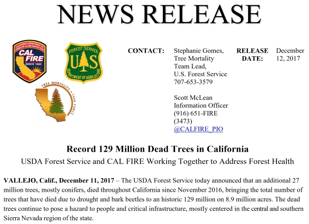
Record 129 Million Dead Trees in California. Here’s the press release from USDA and CAL FIRE.
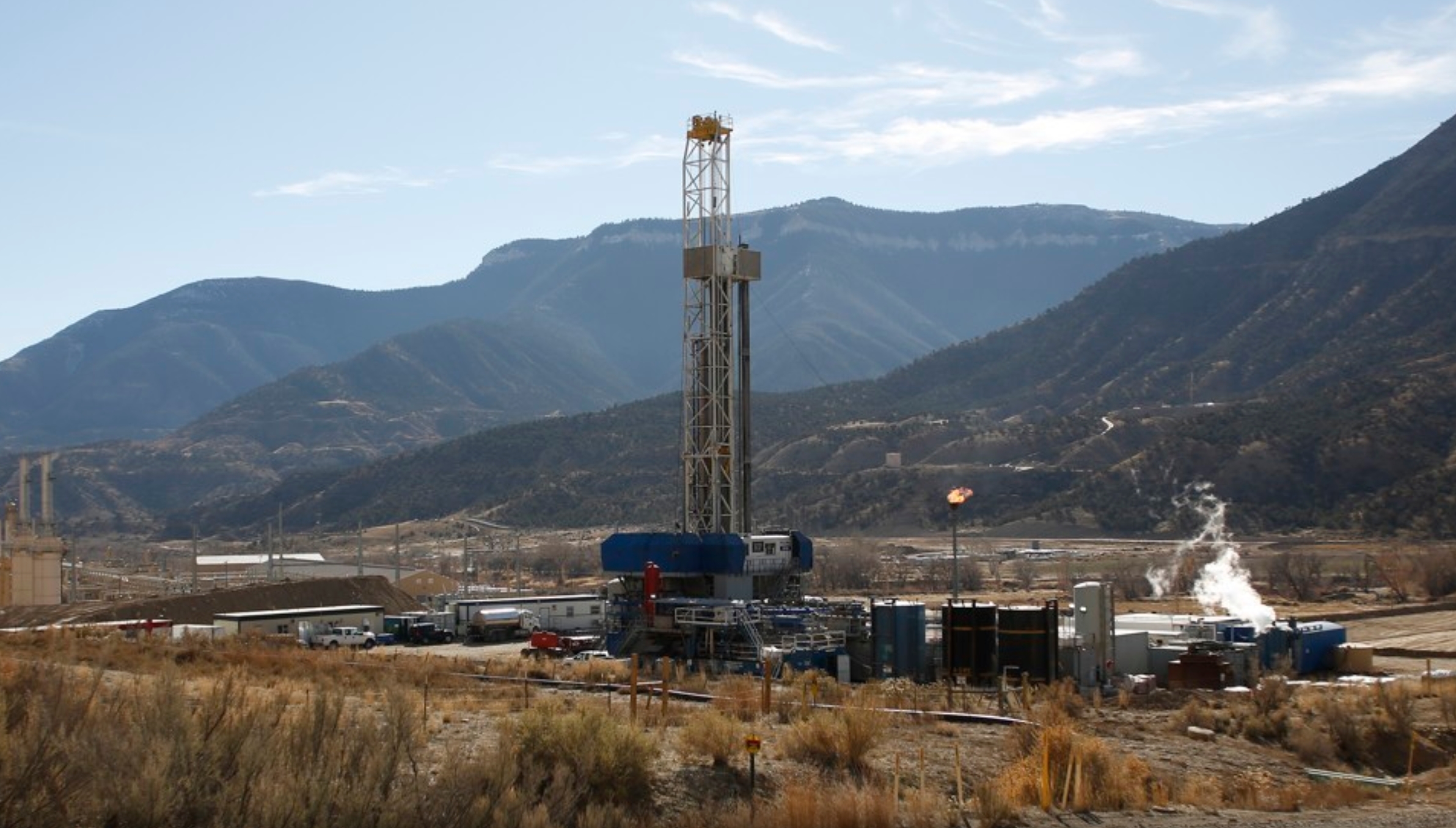
New Major Evidence That Fracking Harms Human Health. The Atlantic reports: “Hydraulic fracturing, or fracking, may pose a significant—but very local—harm to human health, a new study finds. Mothers who live very close to a fracking well are more likely to give birth to a less healthy child with a low birth weight—and low birth weight can lead to poorer health throughout a person’s life. The research, published Wednesday in Science Advances, is the largest study ever conducted on fracking’s health effects. “I think this is the most convincing evidence that fracking has a causal effect on local residents,” said Janet Currie, an economist at Princeton University and one of the authors of the study…”
Photo credit: “A fracking well in Colorado.” Jim Urquhart / Reuters.
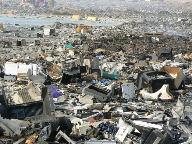
Just 20% of E-Waste is Being Recycled. Every year the world tosses a million tons worth of chargers alone. Ars Technica has the story: “…Apart from a story here and there about a new e-waste recycling project, it’s hard to get an idea of just how much e-waste is getting tossed around the world. A new report from the United Nations’ International Telecommunication Union helps paint a picture by providing some global statistics. Altogether, the report estimates that nearly 45 million tons of electronics were thrown out in 2016—and only about 20 percent of it is known to have been recycled. The report puts the value of the raw materials in that 45 million tons of e-waste at about $55 billion ($9 billion from smartphones alone), but most of that waste isn’t being recovered...”
Photo credit: Olcese Services.
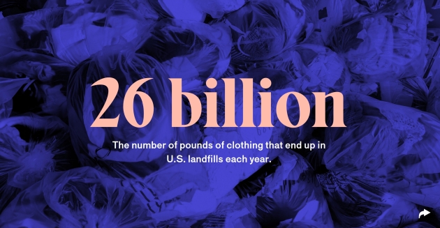
Clothing Companies Are Trashing Unsold Merchandise Instead of Donating It. Here’s an excerpt from a story at The Outline: “…There are a few reasons retailers — high-end clothing companies in particular — would rather destroy unsold merchandise than attempt to donate it. In a 2010 Slate post, fashion journalist Erika Kawalek claimed she knew of a “VERY high-up and profitable” fashion label that “sent two million dollars worth of clothing and purses to the shredder” rather than donating the goods, lest its wares end up on the unwashed masses “or in some unsightly discount bin.” Even fast-fashion retailers like H&M were worried that donating unsold clothing would undercut their business — why pay full price for an H&M shirt if you can just get one at a thrift store?...”
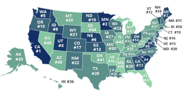
Minnesota’s Drivers Among Worst in the USA. Excerpts from GoMN and QuoteWizard: “…Minnesota saw big increases in accidents, speeding and citations between 2016 and 2017, which caused the state to rise from 11th in the table last year to 2nd this year. Only California has worse drivers, the website says. One of the biggest movers from 2016 to 2017, Minnesota climbed nine spots from 11th to second worst drivers in the nation. By our metrics, Minnesota saw big increases in accidents, speeding, and citations. We’re not the first to highlight Minnesota’s driving, with one transplant describing the state’s drivers as “too fast, too slow, too angry.” What’s causing this? For one, Minnesota’s brutal weather – including ice, snow storms, and tornados – turns cars into Zambonis. Second, the infamous ‘Minnesota Nice’ makes drivers passive-aggressive and indecisive behind the wheel. If you find yourself driving through the streets of Minneapolis, keep your wits about you...” (Map credit: QuoteWizard.com).

The Problem With Muzak. Is Spotify the devil? Not sure (I too have a subscription) but an analysis at The Baffler made me stop and think: “…But Spotify’s worth is more ephemeral. Its value—what makes it addictive for listeners, a necessity for artists, and a worthwhile investment for venture capitalists—lies in its algorithmic music discovery “products” and its ability to make the entire music industry conform to the new standards it sets. This means one thing: playlists are king, and particularly the ones curated by Spotify itself. An unprecedented amount of data (“skip rates” and “completion rates” determine whether a song survives) and “human-machine technology” are deployed to quantify your tastes. This is what lies behind the “magic” of Spotify...”

Vatican Using Milk to Paint Its Buildings. CNN Style reports: “The Belvedere Palace, which dates back to 1484 and houses precious art of the Vatican Museums, is currently being re-painted with milk. It’s an ancient recipe that has proven more lasting than any modern synthetic paints: “We’re not nostalgic for the past,” said the Vatican’s chief architect, Vitale Zanchettin. “The point is that we think these solutions age better. They are tried and tested.” In line with Pope Francis’ emphasis on ecology, the milk itself comes from the Pope’s cows, raised at the papal summer residence of Castel Gandolfo, just outside of Rome. It is mixed with slaked lime and natural pigments, in this case, the original cream color used in the 1500s and hand-patted onto the walls with a centuries-old technique…”
Photo credit: “The small production of milk is branded “Ville Pontificie.” Credit: CNN.
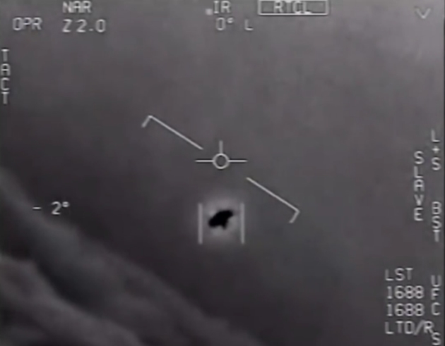
UFO Update. From Muck Rack Daily: “Wow, thus, uh, is something,” tweets Chris Krewson. He’s referring to The Pentagon’s Secret Search for UFOs, by Bryan Bender for POLITICO Magazine. “2017 — when the Pentagon acknowledging a secret UFO program seems like one of the *least* weird stories of the year,” tweets Dan Diamond. Helene Cooper, Ralph Blumenthal and Leslie Kean of The New York Times also report on the story (with video), in Glowing Auras and ‘Black Money’: The Pentagon’s Mysterious U.F.O. Program. Tweets Samantha Storey, “I think the @nytimes just discovered proof of UFO’s, but because this year has been insane we’re all ¯\_(ツ)_/¯.” “Share this before they reveal themselves,” says Patrick LaForge. “This is not a great time for aliens to meet us,” notes Liam Stack.”
41 F. maximum temperature on Monday in the Twin Cities.
26 F. average high on December 18.
2 F. high on December 18, 2016, after waking up to -20 F.
December 18, 1983: Record lows are set across central Minnesota with temperatures ranging from fifty degrees below zero to the upper twenties below zero. Mora set their record with a low of 52 below, with 42 below at Little Falls, 41 below at Jordan, St. Cloud, and Cambridge, and 39 below at Long Prairie, Milaca, and Stillwater.
December 18, 1923: Unseasonably mild temperatures occur in Minnesota. Temperatures climb into the 60s at New Ulm.
TODAY: Partly sunny, pleasant. Winds: NW 10-20. High: 35
TUESDAY NIGHT: Clouds increase, flurries late. Low: 19
WEDNESDAY: Light snow or freezing drizzle. Icy coating. Winds: E 5-10. High: 29
THURSDAY: Couple of inches of snow. Slow commutes. Winds: NE 10-15. Wake-up: 23. High: 27
FRIDAY: Light snow lingers, another inch? Winds: NW 8-13. Wake-up: 14. High: 20
SATURDAY: Lot’s of clouds, getting colder. Winds: NW 10-15. Wake-up: 5. High: 10
CHRISTMAS EVE: Feels like -15F. Santa not amused. Wake-up: -6. High: 3
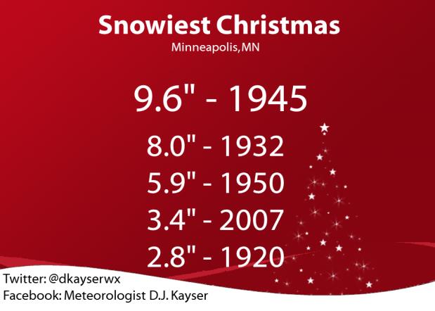
CHRIESTMAS DAY: Extra layers! Coldest X-Mas since 1996. Wake-up: -8. High: -2
-20 air temperature by the middle of next week?
Climate Stories….
What Minnesota Can Do Now to Regain Leadership on Climate Change. Here’s an excerpt of an Op-Ed at Star Tribune: “This week, 19 of 20 countries with the largest economies in the world met in France to discuss how bold, global action can prevent a climate catastrophe. The United States is the one nation missing from this vital conversation. This comes on the heels of the annual meeting of countries that are signatories to the Paris Climate Agreement. During that global summit last month, Syria joined the Paris Agreement, leaving the U.S. as the only national government in the world not working to prevent disastrous climate change. In contrast, Minnesota was well-represented at the global climate summit in Germany. Delegations from Climate Generation: A Will Steger Legacy, the University of Minnesota, Macalester College and Fresh Energy included legal and policy experts, political leaders, youth and business. We returned with a commitment to ensure that Minnesota is a climate leader. We’re writing today because Minnesota needs to act now with specific policies to ensure that our leadership is more than mere words…”
Climate Changes is Already Wreaking Havoc on our Weather, Scientists Find. TIME has the story; here’s the intro: “The Arctic is melting with no turning back. Climate change increased rainfall during Hurricane Harvey by at least 15%. And several extreme weather events that occurred in 2016 would not have been possible without man-made global warming. These are among the findings being discussed this week at this fall’s meeting of the American Geophysical Union in New Orleans, the largest gathering of Earth scientists in the world. Taken together, the findings show the deepening urgency of the fight against climate change. “Climate change is hurting us without a doubt,” said James Byrne, a professor at the University of Lethbridge who studies climate change, at a press conference...”
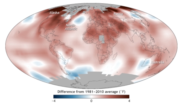
Human Influence on Climate Led to Several Major Weather Extremes in 2016. NOAA’s Climate.gov has the story: “Last year’s record global heat, extreme heat over Asia, and unusually warm waters in the Bering Sea would not have been possible without human-caused climate change, according to new research in Explaining Extreme Events in 2016 from a Climate Perspective, a report published today as a special supplement to the Bulletin of the American Meteorological Society (BAMS). In the six years scientists have been producing this annual report, this is the first time they have found that extreme events could not have happened without human-caused warming of the climate through increases in greenhouse gases. “This report marks a fundamental change,” says Jeff Rosenfeld, editor-in-chief of BAMS. “For years scientists have known humans are changing the risk of some extremes. But finding multiple extreme events that weren’t even possible without human influence makes clear that we’re experiencing new weather, because we’ve made a new climate...”
Map credit: “2016’s new record-high global temperature was among a handful of extreme events that research indicated would not have happened without human-caused warming.”
Climate Change Could Mean Trouble for Skiers, Anglers. Here’s an excerpt from US News: “…Focusing their research in the Merrimack River watershed in south-central New Hampshire, a research team led by scientists at the University of New Hampshire found that snow days could decline by mid-century from 60 to 18, while there could be as many as 45 summer days when temperatures soar above 90 degrees — compared with 10 currently. The study also found that there would be increased risk of flooding at mid-century and a steep decline in stream habitat, resulting in 40 percent becoming uninhabitable for cold-water fish favored by fishermen, like trout. “Starting in about 20 or 25 years from now, that is where we see a noticeable shift. … The implication is that things are really going to change at that point,” Wilfred Wollheim, a co-author on the study and an associate professor in the university’s Department of Natural Resources and the Environment...”
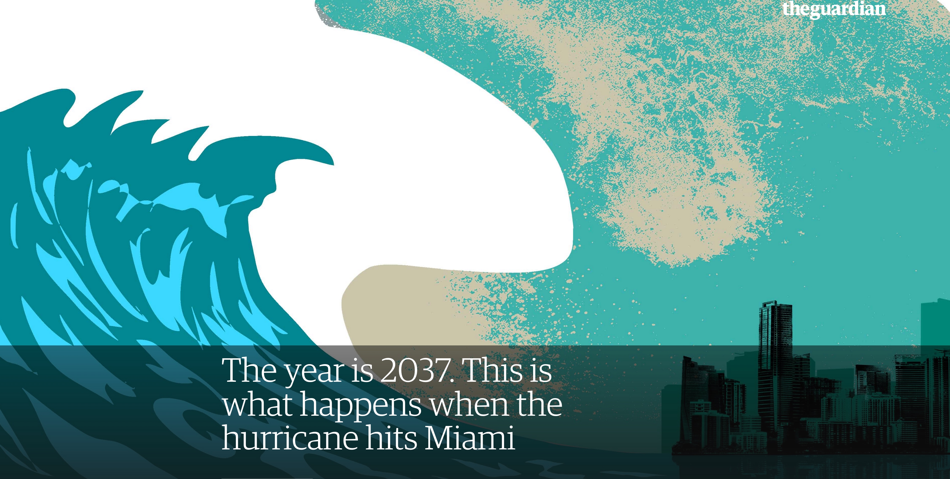
The Year is 2037. This is What Happens When the Hurricane Hits Miami. The Guardian excerpts Jeff Goodell’s book, “The Water Will Come: “After the hurricane hit Miami in 2037, a foot of sand covered the famous bow-tie floor in the lobby of the Fontainebleau Hotel in Miami Beach. A dead manatee floated in the pool where Elvis had once swum. Most of the damage came not from the hurricane’s 175-mile-an-hour winds, but from the twenty-foot storm surge that overwhelmed the low-lying city. In South Beach, historic Art Deco buildings were swept off their foundations. Mansions on Star Island were flooded up to their cut-glass doorknobs. A seventeen-mile stretch of Highway A1A that ran along the famous beaches up to Fort Lauderdale disappeared into the Atlantic. The storm knocked out the wastewater-treatment plant on Virginia Key, forcing the city to dump hundreds of millions of gallons of raw sewage into Biscayne Bay...”
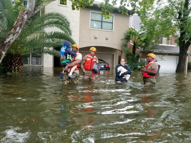
Hurricane Harvey Studies: Yesterday’s 100-Year Storm is Today’s 30-Year Storm. Here’s an excerpt from a story at Ars Technica: “…A second study, published by Mark Risser and Michael Wehner at Lawrence Berkeley National Laboratory, performed a similar analysis of past weather station records. Their methods were a little different: they focused on 7-day rainfall totals rather than 3-day totals, for example, and checked for the influence of El Niño/La Niña conditions. But their results were basically the same. They estimate that Harvey’s rainfall was probably almost 19 percent higher due to global warming, which also means the probability of a storm of Harvey’s size is now 3.5 times more likely. The researchers use the previous record-high 7-day rainfall as an example. In 1950, that would have been about a 200-year storm. But in 2017, it is closer to a 30-year storm…”
Photo credit: Texas Military Department.
Global Warming Tied to Hurricane Harvey. Research highlighted at Scientific American predicts that Harvey’s record rainfall was three times more likely than a storm from the early 1900s: “Climate change made Hurricane Harvey more powerful and increased its deadly flooding, according to new research released as major storms may be driving more Americans to worry about global warming. Human-caused climate change caused the storm to drop significantly more rain than storms would have before atmospheric carbon dioxide levels spiked from the consumption of fossil fuels, according to research published yesterday. Meanwhile, a new poll suggests that witnessing that type of damage and the suffering of those affected has also seemed to move public opinion slightly toward an acceptance of the risk that it poses to a large segment of the U.S. population...”
Hurricane Harvey file photo: Tom Fox, Dallas Morning News.
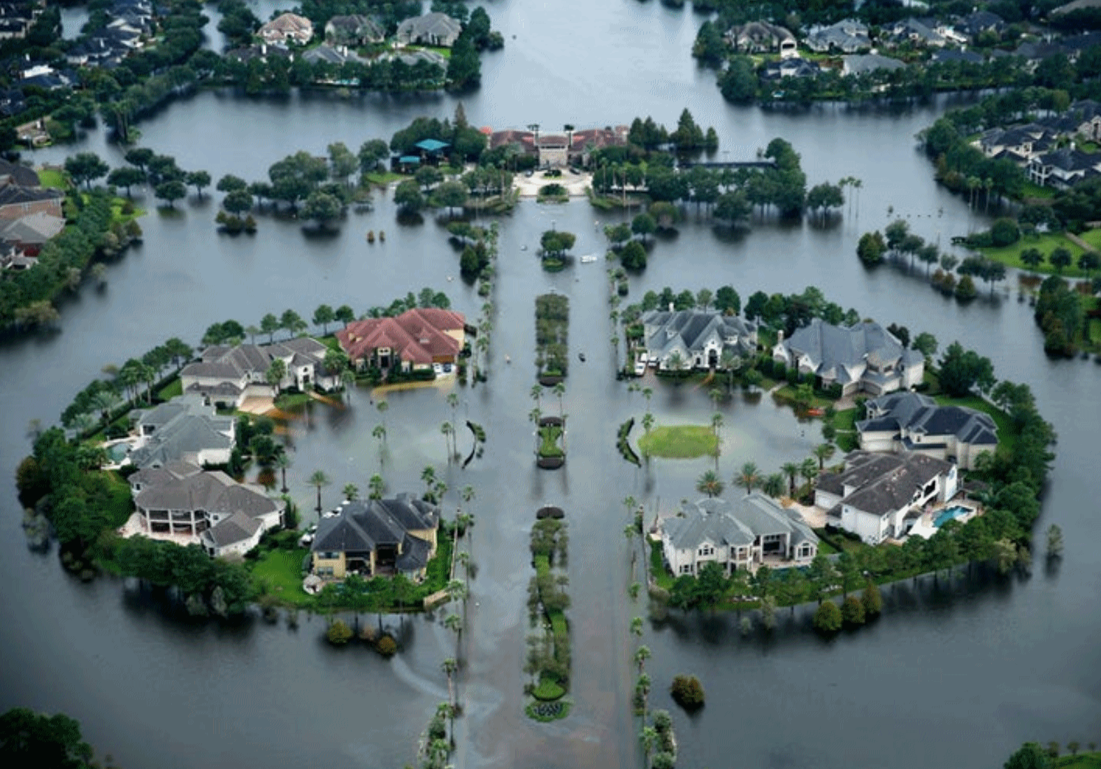
Scientists Link Hurricane Harvey’s Record Rain to Climate Change. A warming atmosphere made the probability of Hurricane Harvey’s 50″+ rains as much as 38% more likely, according to 2 new studies highlighted at The New York Times.
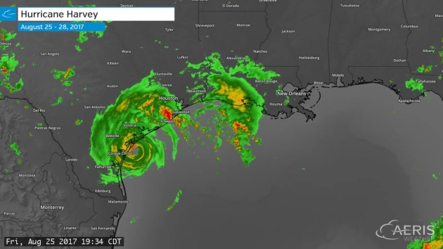
3-Day Hurricane Harvey radar loop with 2-minute updates from August 25-28, 2017, courtesy of AerisWeather.
Climate Change Made Harvey’s Rainfall Three Times More Likely, Scientists Say: From Climate Nexus Hot News: “Climate change made Hurricane Harvey’s record-breaking rainfall much worse, scientists reported this week. Peer-reviewed research from the World Weather Attribution initiative, presented Wednesday at the American Geophysical Union conference in New Orleans, found that climate change made the hurricane’s rainfall totals 15 percent more intense than normal. Meanwhile, separate research published in the journal Geophysical Research Letters and also presented at AGU found that climate change likely increased Harvey’s rainfall by 20 percent, and possibly as much as 38 percent. Harvey’s record-breaking rainfall in August totaled 50 inches in some areas of Houston.” (New York Times $, AP, Washington Post $, The Guardian, CNN, Houston Chronicle, Mother Jones, National Geographic, Huffington Post)
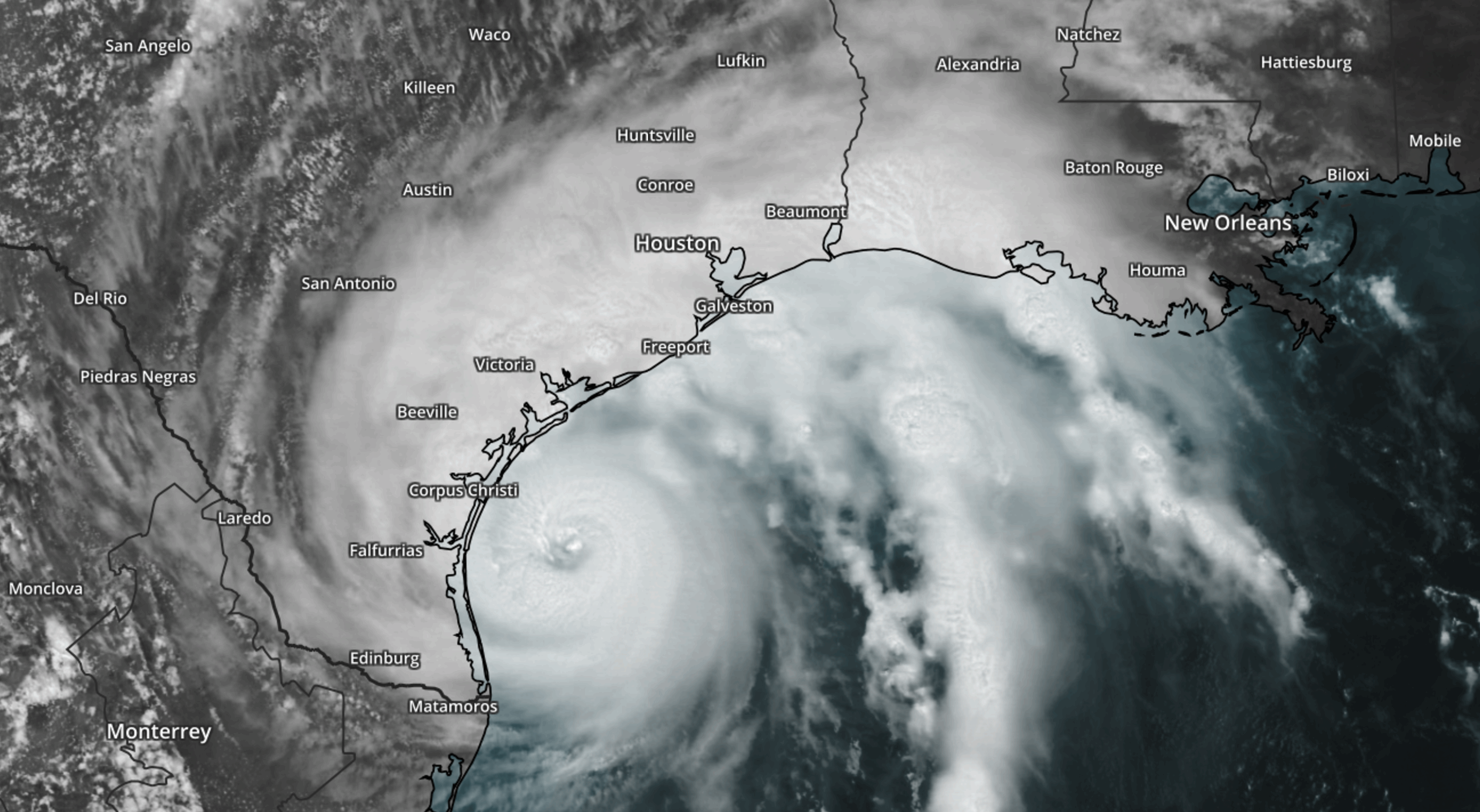
Hurricane Harvey file image: NOAA and AerisWeather.