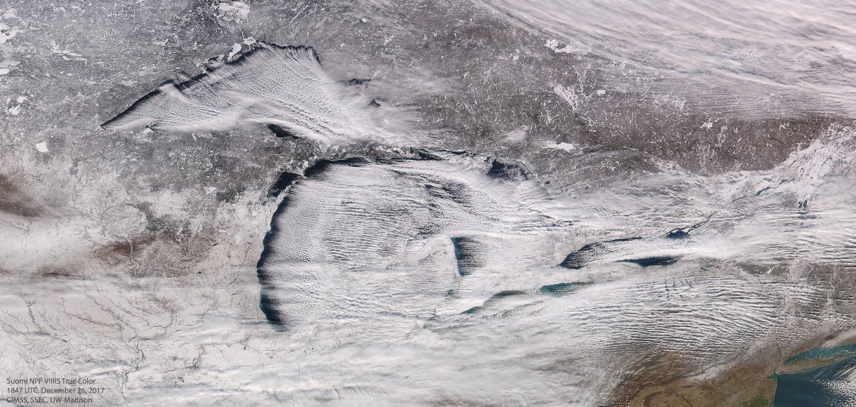
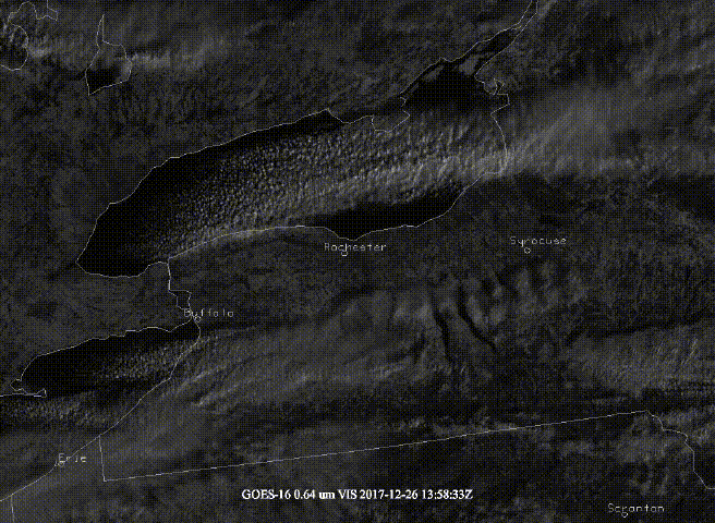
Lake Effect Snow From Space
.png)
.gif)
____________________________________________________________________
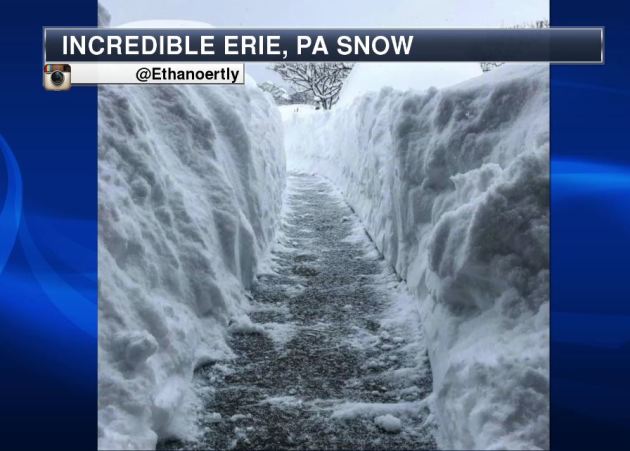
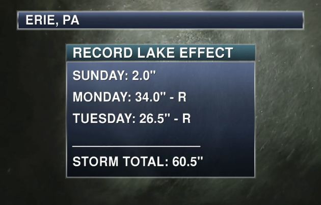
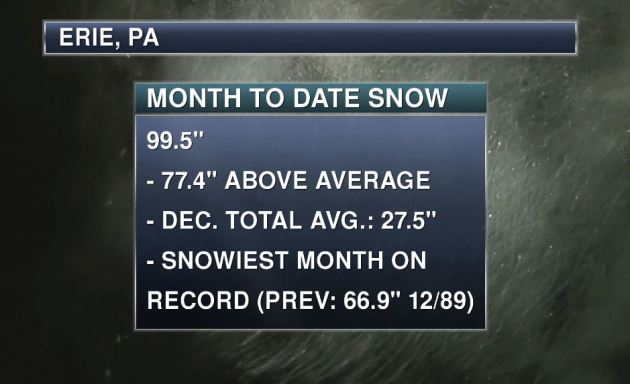
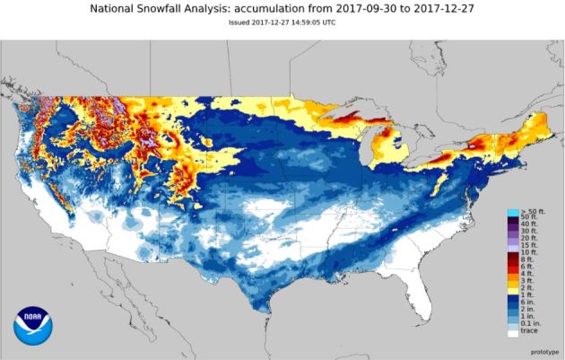
Erie, PA – Snow This December
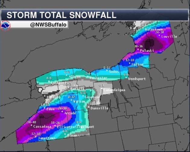
With the near 5 FEET of snow that has fallen since Sunday, the monthly snowfall total is now near 100″, which is nearly 6 FEET above normal! This is also the SNOWIEST month on record beating the previous of 66.9″ set in December of 1989 by nearly 3 FEET! Unreal!!
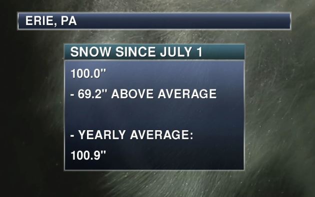
Erie, PA – Snowfall So Far This Season
The seasonal snowfall tally in Erie, PA is now up to 100″, which is nearly 6 FEET above average so far this season. Note that the yearly average is 100.9″, so Erie, PA has already had their yearly average snowfall through December 26th!
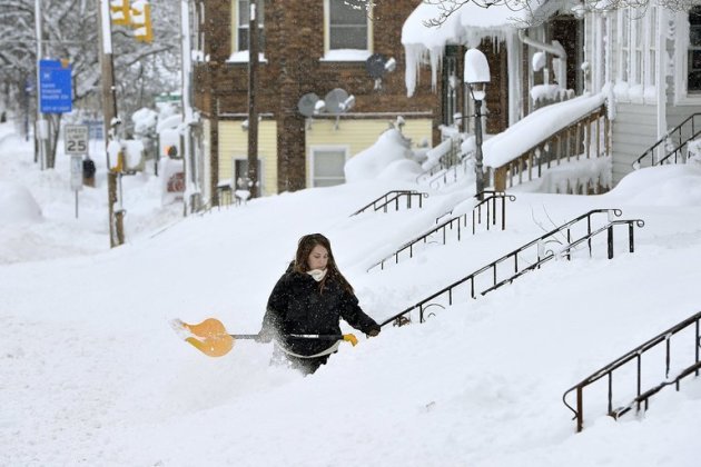
_______________________________________________________________________________ “Erie, Pa., Buried in Five Feet of Snow After Record-Breaking Storm”
____________________________________________________________________________
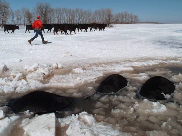

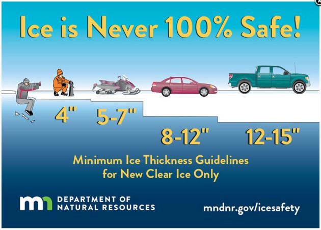
Under 4″ – STAY OFF
4″ – Ice fishing or other activities on foot
5″ – 7″ – Snowmobile or ATV
8″ – 12″ – Car or small pickup
12″ – 15″ – Medium truck
Many factors other than thickness can cause ice to be unsafe.
White ice or “snow ice” is only about half as strong as new clear ice. Double the above thickness guidelines when traveling on white ice.
___________________________________________________________________
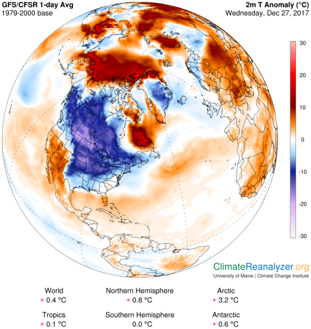
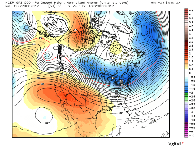
Arctic Air MassArrives
.gif)
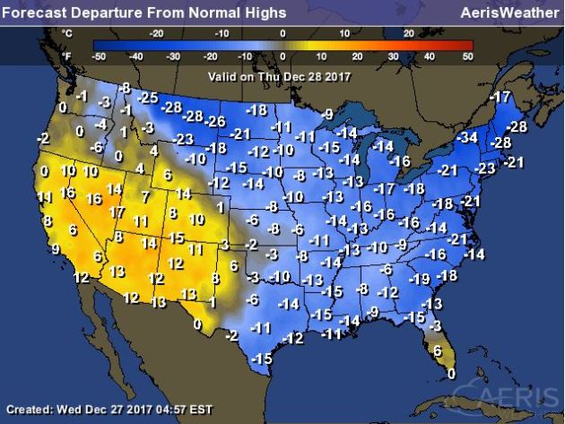
High Temps Thursday
High temperatures on Thursday will still be VERY chilly across much of the country with temperatures running nearly 10F to 20F+ below average. Meanwhile, warmer than average temperatures will continue in the southwestern part of the country and also in southern Florida.

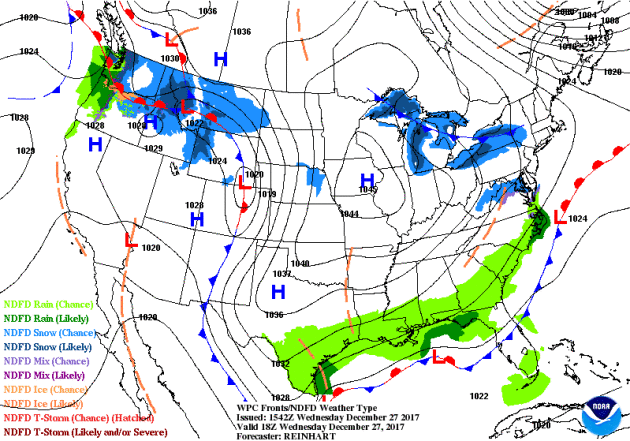
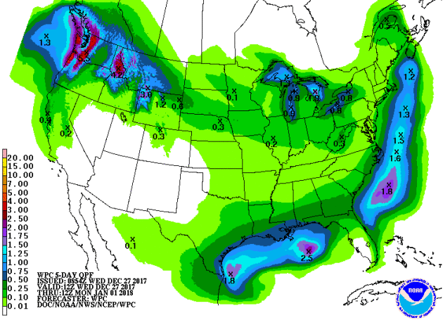
According to NOAA’s WPC, the 5 day precipitation outlook suggests areas of heavier precipitation continuing across the Northwestern part of the country through AM Sunday. Some of the higher elevations there could see several inches of liquid accumulation, which could lead to feet of snow! There may also be areas of heavier rain along the Coast of Texas and also along the Gulf Coast States.
___________________________________________________________________________
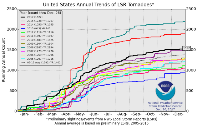
It certainly has been a fairly active first half of 2017 with 1,522 preliminary tornado reports through December 26th. Note that this is the most tornadoes through that date since 2011, when there were 1,897 reports. The map below shows the distribution of the tornadoes so far this year.
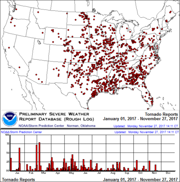
PRELIMINARY 2017 Tornado Count
According to NOAA’s SPC, the PRELIMINARY 2017 tornado count is 1,522 (through December 26th). Note that is the most active year for tornadoes since 2011, when there were 1,897 tornadoes. Notice that the only other year with more tornadoes than this year was in 2008, which ended with a whopping 2,140 tornadoes nationwide.
_____________________________________________________________________
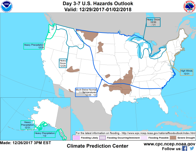
National Weather Hazards Ahead…
1.) Heavy precipitation across portions of the Pacific Northwest, Fri, Dec 29.
2.) Heavy snow across portions of the Pacific Northwest and the Northern Rockies, Fri, Dec 29.
3.) Heavy snow across portions of the Great Lakes, Sat-Mon, Dec 30-Jan 1.
4.) High winds across portions of the Mid-Atlantic, the Northeast, and the Great Lakes, Sun, Dec 31.
5.0 Much below normal temperatures from the Northern Rockies to the Great Plains, Mississippi Valley, Great Lakes, Ohio Valley, Tennessee Valley, Appalachians, Northeast, Mid-Atlantic and portions of the Southeast, Fri-Tue, Dec 29-Jan 2.
6.) Heavy precipitation across portions of south coastal mainland Alaska, Sun, Dec 31.
7.) Heavy precipitation across portions of the Alaska Panhandle, Tue, Jan 2.
8.) Slight risk of much below normal temperatures for portions of the Great Plains, the Mississippi Valley, the Central Appalachians, the Tennessee Valley, the Great Lakes, Ohio Valley, the Northeast, the Mid-Atlantic, the Southern Appalachians, and the Southeast, Wed-Sat, Jan 3-Jan 6.
9.) Moderate risk of much below normal temperatures from the Mississippi Valley to the East Coast, Wed-Fri, Jan 3-Jan 5.
10.) High risk of much below normal temperatures for portions of the Northeast, the Central Appalachians, the Tennessee Valley, the Mid-Atlantic, the Southern Appalachians, the Southeast, the Great Lakes, and the Ohio Valley, Wed-Thu, Jan 3-Jan 4.
11.) Slight risk of heavy precipitation for portions of the Central Plains, the Southern Rockies, the Southern Plains, and the Southwest, Fri-Sat, Jan 5-Jan 6.
12.) Severe Drought across the Central Plains, the Lower Mississippi Valley, the Central Great Basin, the Northern Plains, Hawaii, the Northern Rockies, the Middle Mississippi Valley, the Southern Plains, and the Southwest.
_____________________________________________________________________
Perils of Frostbite – January Thaw 2 Weeks Away?
By Paul Douglas
A friend of mine went on a rant yesterday, railing against the evils of four-wheel-drive. Say what? “It gives people a false sense of security! People drive when they shouldn’t be driving, and many of them aren’t dressed for the weather. If they get stuck, they’re in serious trouble!”
I see his point. If you wind up in a ditch wearing a T-shirt, there may not be a happy ending.
Children are more prone to frostbite than adults; they experience heat loss from their skin more rapidly. Younger people who have diabetes, have had a recent injury, surgery, or blood loss are at enhanced risk as well.
Thursday’s clipper may put down a fresh carpet of 1-3 inches of light, powdery, Aspen-like snow. When it’s this cold salt doesn’t melt ice nearly as effectively, so plan on a very slow commute.
More light snow streaks in Friday ahead of the next punch of polar air. Temperatures may not climb above 0F Saturday & Sunday; dipping below 0F every night next week. More herd-thinning cold.
Good news if you don’t like numb toes: a Pacific breeze returns the second week of January with a thaw!
________________________________________________________________________
Extended Forecast
THURSDAY: 1″ to 3″ of snow. Icy commutes. Winds: S 7-12.. Wake-up: 0. High: 12.
THURSDAY NIGHT: Mostly cloudy and cold. Feels like: -15F. Winds: WNW 5. Low: -4.
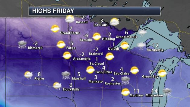
FRIDAY: More light snow. Turning even colder. Winds: NW 8-13. High: 3.
SATURDAY: Polar fun. Feels like -30F AM hours. Winds: NW 8-13. Wake-up: -13. High: -2.
SUNDAY: Mix of clouds and sun. “Viking Cold”. Winds: NW 8-13. Wake-up: -11. High: -1
MONDAY: Sunny, brisk start to 2018. Winds: W 5-10. Wake-up: -13. High: 3
TUESDAY: Teens (above) feels amazingly good. Winds: SW 7-12. Wake-up: -4. High: 16.
WEDNESDAY: Another shot. Feels like -25F. Winds: NW 8-13. Wake-up: -4. High: 3.
_______________________________________________________
This Day in Weather History
December 28th
2000: Central and southeast Minnesota receive 6 to 10 inches of snow. Some notable snow amounts include: Chanhassen NWS Forecast Office with 7.8 inches, St Cloud with 7.5 inches, and Hutchinson, Willmar, Albany, Red Wing, and Long Prairie with 7.0 inches.
1979: Balmy weather enables the city park crew in Duluth to rake leaves.
1927: A cold snap results in sharp temperature drops across Minnesota. The temperature would fall from 41 to -15 at Farmington.
_______________________________________________________
Average High/Low for Minneapolis
December 28th
Average High: 24F (Record: 47F set in 2013)
Average Low: 9F (Record: -27F set in 1880)
Record Rainfall: 1.09″ set in 1982
Record Snowfall: 12.0″ set in 1982
_________________________________________________________
Sunrise/Sunset Times for Minneapolis
December 28th
Sunrise: 7:50am
Sunset: 4:39pm
Hours of Daylight: ~8 hours 48 mins
Daylight GAINED since yesterday: ~32 seconds
Daylight GAINED since winter solstice (December 21st): 2 minute
__________________________________________________________
Moon Phase for December 28th at Midnight
2.9 Since First Quarter Moon
.gif)
_________________________
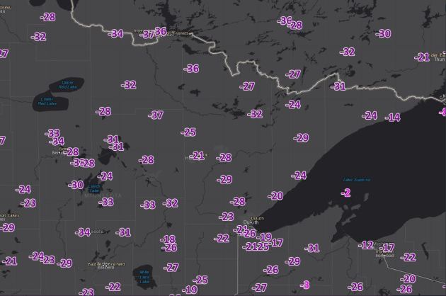
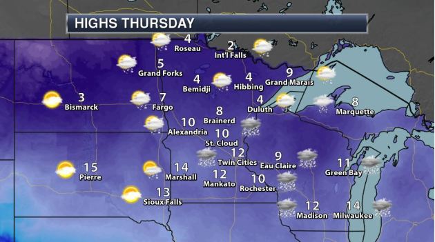
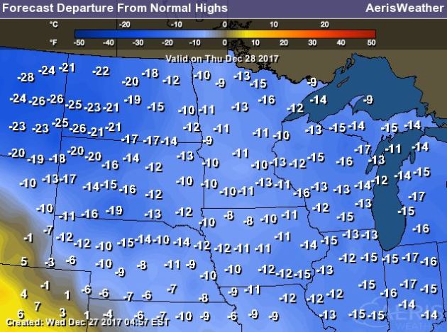
High temps on Thursday will still be quite cold across much of the region with readings still nearly -10F to -25F below average! However, it’ll be a touch warmer due to some light snow potential. Some locations across the far northern reaches of Minnesota will have a tough time making it above 0F for once again.
__________________________________________________________________________
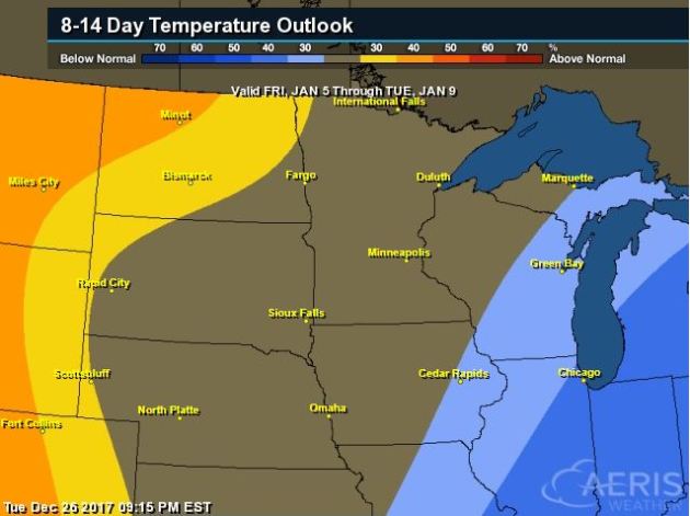
Here’s the temperature outlook into the 2nd week of January, which suggests the MUCH colder than average temperatures moving farther east into the Great Lakes Region and Ohio Valley. Note that warmer than average temperature may actually start moving back in across the High Plains.
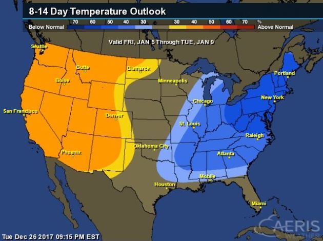
8 to 14 Day Temperature Outlook
Here’s the extended temperature outlook from January 5th to January 9th, which suggests colder than average temperatures sticking around through much of the eastern half of the nation, while warmer than average weather will be found in the Western US.
____________________________________________________________________________
____________________________________________________________________________
____________________________________________________________________________
____________________________________________________________________________
_____________________________________________________________________________
Thanks for checking in and don’t forget to follow me on Twitter @TNelsonWX