December 28, 1979: Balmy weather enables the city park crew in Duluth to rake leaves.
December 28, 1927: A cold snap results in sharp temperature drops across Minnesota. The temperature would fall from 41 to -15 at Farmington.
Wednesday Thaw – Reasons to Embrace Numbing Cold
When life gives you (ice-cold) lemons – make Arctic Lemonade! Our coldest days tend to be sunny in Minnesota. Our constellation of lakes are too small to spark persistent lake-effect clouds. There is research suggesting cold weather improves mental acuity; decision-making gets better during the winter!
The crime rate drops and your garbage doesn’t stink. All compelling reasons to celebrate the Nanook.
You buying any of this? Hey, you can’t blame a guy for trying to put a positive spin on an atmospheric near-death experience. January is Minnesota’s coldest, snowiest month, and studying the maps that isn’t hard to believe. No blizzards are brewing but a parade of memorable cold fronts sail into town the first half of January.
Mid-30s will feel good today before a gusty northwest wind tugs the mercury back down to average. No fresh snow for New Year’s Eve festivities; snow Sunday night into Monday may drop a plowable accumulation. Single digit highs and subzero lows are likely next week; another Siberian slap the second week of January.
Looks like we got our Winter Mojo back!
Think Twice Before Going Out on the ice, DNR Warns. The 7-8″ snow that fell on the MSP metro area December 10-11 came after a very mild start to December, before ice had a chance to form evenly. The snow insulated developing lake ice, slowing the rate of ice formation. Here’s an excerpt from Lake Minnetonka Patch: “…The calendar nor air temperatures can be used as indicators of ice thickness or safety,” said Lisa Dugan, DNR recreation safety outreach coordinator, in a statement. “There are many variables to consider, including whether a waterbody has a current or run-off, the freeze-thaw cycle, and snow cover. River have been especially problematic, as water levels have continued to drop even after surface ice formed, creating dangerous air pockets under the ice.” A layer of insulating snow, coupled with above-average temperatures, means new ice takes longer to form, Dugan explained, adding that ice that has thawed and refrozen is only half as strong as new, clear ice...”
The Dogs of Winter May Start Howling Again Soon. I happen to agree with meteorologist Dan Satterfield; here’s an excerpt of a solid blog post at AGU Blogosphere: “There are growing signs that Arctic air may return to the U.S. by late next week as the mild weather pattern of the last ten days begins to fall apart. There is still a lot of uncertainty about whether or not this pattern will lock in or if this will be just a temporary blast of cold before milder Pacific air takes back over. The big clue to these changes is the temperatures in Alaska and Greenland. It’s been quite cold over Alaska over the past two weeks, but the long-range NOAA and Euro models show a strong ridge of high pressure in the upper troposphere building back over the area later next week. This will turn winds aloft over Canada back to the north and steer an Arctic air mass southward. High pressure aloft will also build back over Greenland and this is where we look for some cold and snowy winter weather in the Northeastern U.S. The pressure pattern called the North Atlantic Oscillation (NAO) is heavily dependent on Greenland pressure, and when the pressures go up, the NAO goes into what forecasters call the negative phase…”
Map credit: “This is the NOAA GFS Ensemble. It’s an average of many model runs, and the ECMWF Model run in the UK is also showing much the same. This adds confidence to the forecast. Note the rising pressures over Greenland as well. This would correspond to a slight negative in the NAO.”
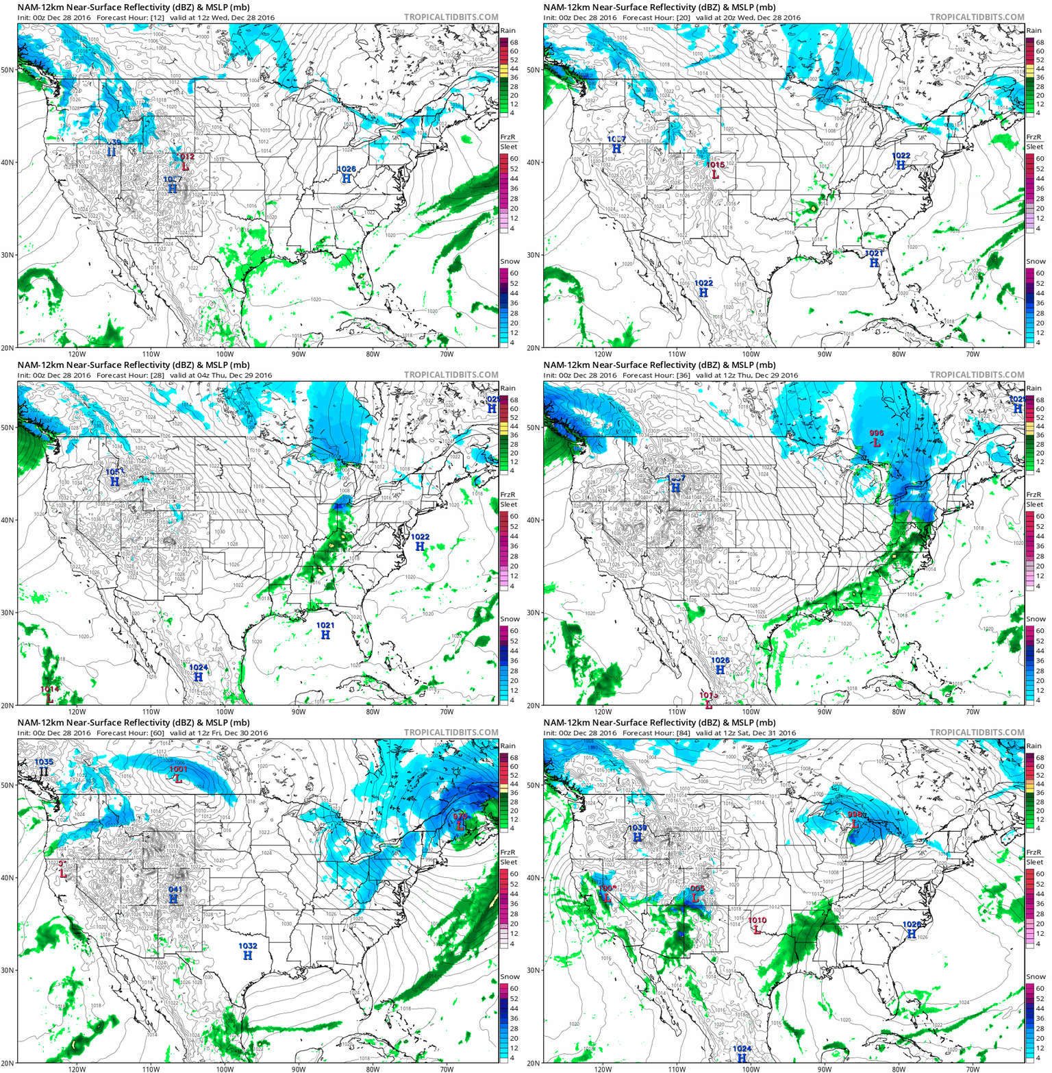
84-Hour Future Radar. NOAA’s 12 KM NAM guidance shows a fairly quiet 3+ days shaping up across the USA; a strong cold frontal passage ending the mild honeymoon for eastern states, while a weak Alberta Clipper brushes far northern states by New Year’s eve – and heavy rain/snow pushes into western Washington State. Source: Tropicaltidbits.com.
10-Day Snowfall Potential. The arrival of bitter air sparks a band of 3-6″ snows across the Midwest next Monday and Tuesday; over a foot predicted from upstate New York to Maine over the next 10 days. A coating to a few inches mayy accumulate over the Mid South and Appalachians in the coming days.
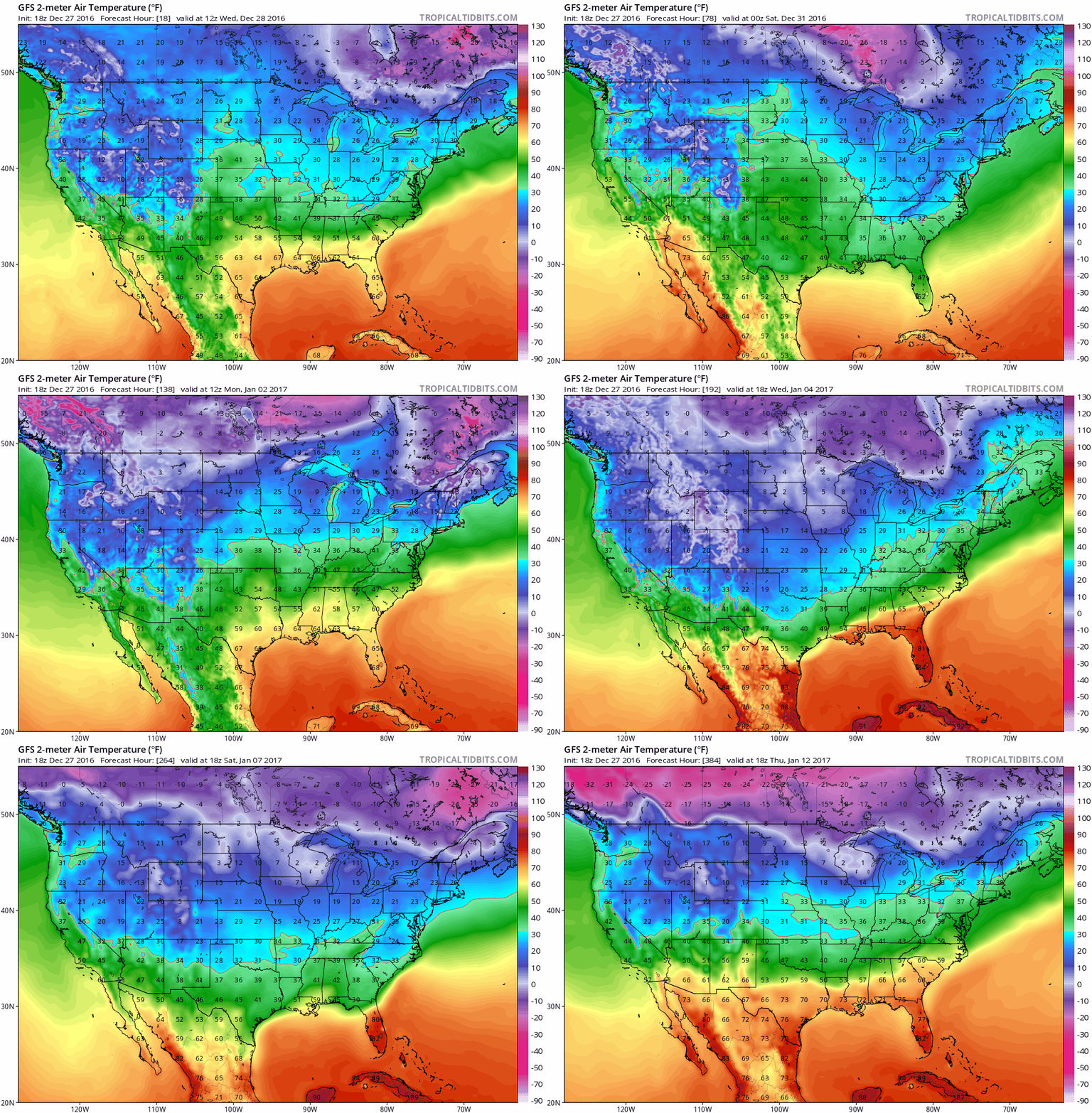
Second Week of January: Bitter North Plains – Mild Gulf Coast. Polar air doesn’t come south all at once, but rather in waves. The GFS model shows bitter aiir pushing into the northern tier states in 2 weeks, probably the second surge of subzero air in sight.
This Looks About Right. Updated. Recent runs of NOAA’s CFSv2 (Climate Forecast System) model looked warm for much of the USA, but last night’s run prints out a bitter bulls-eye from western Canada into the Plains and Upper Midwest, which seems realistic. Meanwhile unusually warm weather may be the rule from Texas and the Gulf Coast into much of New England. Map: WeatherBell.
Year of the Flood: The Nation’s 10 Most Extreme Weather Events of 2016. Jason Samenow reports at The Capital Weather Gang: “In 2016, of all the weather events to affect the nation, four stood out: a hurricane, a flood, a drought and a blizzard. These four were historic and extreme, setting numerous records and affecting large areas. Unfortunately, they caused a great deal of suffering and economic losses. Six other storm events, which were more localized, round out the top 10. Tornadoes were not among this year’s most significant weather events. This year was, generally, a quiet year both in terms of the overall number of tornadoes and tornado fatalities. Much more than wind, in 2016, water (or, in one case, lack of water) caused the lion’s share of weather-related deaths and damages. As seven of the top 10 weather events involved extreme rainfall, and several 1-in-1,000 year events, perhaps you could call it the year of the flood…”
Photo credit: “Fuel tanks are seen after floodwaters rose because of Hurricane Matthew in Lumberton, N.C.” (Chris Keane/Reuters)
The Top 9 U.S. Weather or Climate Events of 2016. Meteorologist Marshall Shepherd has a good overview of another manic year of weather at Forbes: “Like any year, 2016 was characterized by a range of weather-climate events in the United States. On its website, NOAA’s National Center for Environmental Indicators tallied 12 weather or climate related disasters with economic losses greater than $1 billion in the United States as of September. Flooding (4 events) made up most of the list. WBAL weather anchor Miri Marshall, reflecting on the Ellicott City, Maryland floods said, “I have never seen rainfall rates like this in my career and I’ve forecasted in Texas.” It was certainly a “wow” moment in weather to see more than 3″ of rain in roughly 30 minutes.” There were a lot of “wow” moments, and since the NOAA analysis is only through September, it doesn’t even include Hurricane Matthew…”
Doppler radar loop: Hurricane Matthew on October 6, 2016.
4 Ways To Become a Weather Forecast From Your Backyard. Crowdsourcing of weather information is becoming increasingly valuable – consider becoming a professional SKYWARN observer too. Here’s an excerpt from Mental Floss: “…If you’ve ever heard reports of severe weather on the news talking about a “trained spotter,” they’re talking about one of the hundreds of thousands of volunteers who have participated in official storm spotter training. SKYWARN is the official weather spotter training program run by the National Weather Service (NWS). The program is a short, free course run by local NWS offices several times every year. It teaches you the basics of spotting severe and hazardous weather, and properly reporting that weather back to the NWS. SKYWARN spotters are a critical part of the early warning system in the United States. Accurate reports of tornadoes, damaging winds, hail, and flooding sent to the NWS by trained storm spotters have helped meteorologists issue severe weather warnings with enough time to save lives...”
THURSDAY: Cloudy and gusty, few flurries in the air. Winds: NW 15-25. High: near 30
FRIDAY: Some AM sun, then clouds increase. Winds: S 10-15. Wake-up: 17. High: 29
NEW YEAR’S EVE: Gradual clearing, good travel weather. Winds: NW 10-20. Wake-up: 19. High: 27
NEW YEAR’S DAY: Fading sun, light snow at night. Winds: SE 8-13. Wake-up: 16. High: 31
MONDAY: Snowfall amounts may be plowable. Winds: N 10-20+ Wake-up: 22. High: 29
TUESDAY: Peeks of sun, turning much colder – subzero chill factor. Winds: NW 10-15. Wake-up: 9. High: 12
Climate Stories…
What a Record-Breaking Year! Sigh. Grist has the details; here’s a snippet: “The Arctic is getting really hot. Alaska saw its hottest year ever, with temperatures an average of 6 degrees F above normal. Arctic sea ice cover took a nosedive to a new low this fall, as temperatures at the North Pole reached an insane seasonal high nearly 50 degrees above average. Reminder: There is no sun in the Arctic in December. The first year we spent entirely above 400 ppm. After the biggest monthly jump in atmospheric CO2 levels from February 2015 to February 2016, those levels stayed high for all of 2016…”
Map credit: Climate Reanalyzer.
Global Warming is Reshaping the Wine-Making World. Here’s an excerpt of an interesting interview at New Hampshire Public Radio: “…We all know that wine comes from special places, places where the rainfall falls in winter and you have relatively cool summers. And as those places heat up, they’re going to become less suitable for the types of grapes that are currently grown there. And then some other places are going to become more suitable. So places like Tasmania and Denmark even are now becoming more suitable for growing wine grapes...”
The Navy Adapts to Rising Sea Levels. Here’s an excerpt from Marketplace: “…Base officials said they are planning a redesign, using a combination of retiring some buildings, expanding wetlands and dunes, and installing hard protections like seawalls where necessary. “Those are things that we’re going to look at very closely and try to make those wise decisions, because they are they are expensive decisions, and we want to make the right decisions, so we have the right facilities in the right place,” said Diane Legere-Jump, facilities management division director for public works at Naval Base Ventura County…”
Photo credit: “Waves crash over a sea wall at Naval Base Ventura County.” Courtesy of Naval Base Ventura County
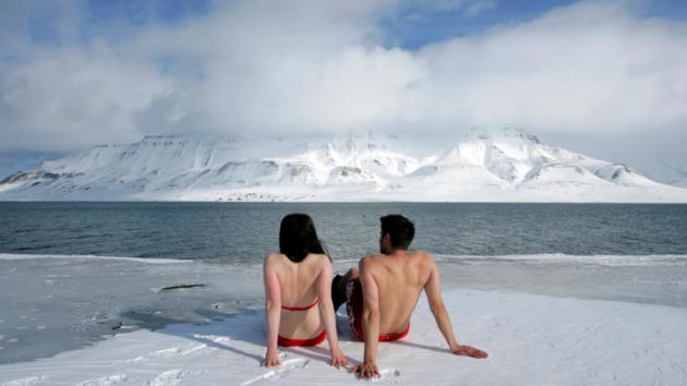
There’s No Future in Despising Humanity. Negative thinking about climate change is ultimately self-defeating, according to a story at Slate: “…Such apocalyptic imagery may be more likely to become a self‐fulfilling prophecy than to rouse people to action. Currently I feel that spewing misanthropy is just as dangerous as emitting carbon dioxide. It is the opposite of activism. There is a real danger of unintended consequences, of encouraging people to give up. Pessimism, if it becomes a habit, can reinforce a narrative of unstoppable decline. If there is nothing we can do, that releases us from our obligations. There’s no future in despising humanity. Self‐flagellation may feel good to some, but how does it help move us toward solutions? Surely we can find a way to love Earth without hating ourselves...”
File photo: Reuters.
States Will Lead on Climate Change in the Trump Era. Here’s an excerpt of an Op-Ed from the Editorial Board at The New York Times: “State governments will serve as an important bulwark against any attempt by President-elect Donald Trump to roll back the progress the United States has made in addressing climate change. And that’s good news for the planet. Over the last decade or so, most states have reduced their greenhouse gas emissions by promoting energy efficiency and renewable fuels. These trends should continue as clean energy costs continue to decline and, in some parts of the country, fall below the cost of dirtier fuels like coal. The Brookings Institution reported this month that between 2000 and 2014, 33 states and the District of Columbia cut carbon emissions while expanding their economies. That list includes red states run by Republican legislatures, like Alaska, Georgia, Tennessee and West Virginia…”
‘Orwellian’: Scott Walker Administration Quietly Scrubs “Climate” from Climate Change Website. Maybe if we ignore it it’ll go away? That sounds like a good strategy. More on what’s happening in Wisconsin from Raw Story: “…Political writer James Rowen reported on Monday that the Walker administration had advanced their war on science by scrubbing information about climate change from a Wisconsin Department of Natural Resources website that was dedicated to explaining how the agency would deal with a warming planet. The DNR page titled “climatechange.html” originally acknowledged that “[h]uman activities that increase heat–trapping (‘green house’) gases are the main cause [of global warming.] Earth´s average temperature has increased 1.4 °F since 1850 and the eight warmest years on record have occurred since 1998.” In all, 13 mentions of “climate” where stripped from the page along with all references to global warming. The word “climate” now appears only in the title of a footnote link at the bottom of the page…”

Katharine Hayhoe: Why Climate Change Should Matter To You. Here’s an excerpt from Dr. Hayhoe at EcoWatch: “…This hard truth has always stuck with me and it’s one of the main reasons I’m motivated to study climate science: because it affects all of us, but most of all the poor the world over—those who already lack sufficient food, who are already at risk for diseases that no one should be dying from in the twenty first century, and who—when disaster strikes—have no choice other than to leave behind their homes and flee. Climate change isn’t a niche issue that only matters to people who think or act or vote a certain way. Each of us, exactly who we are, with exactly the values we already have, already have every reason we need to care. So what’s our job, as people who care about climate? Our job is this: connect the dots between what some have called the longest distance in the world, from our heads to our hearts…”

