A Top Twenty Snowiest January On Record
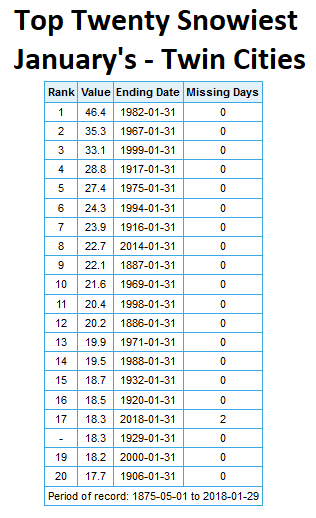
It’s amazing what one snowstorm can do for our snowfall totals. On the back of the 12.4″ of snow we saw on the 22nd, we will end the month as one of the top twenty snowiest January’s on record in the Twin Cities, with over 18″ of snow falling. As of Monday we were tied for 17th place, but any additional snow Tuesday night into Wednesday (which is expected to be light) could help either give us total control of 17th place or push us higher in the rankings.
_______________________________________________
One More Warm Day Today – Cold Start To February
By D.J. Kayser, filling in for Paul Douglas
While this January will end as one of the top 20 snowiest January’s on record in the Twin Cities, other parts of the state haven’t been as lucky precipitation-wise recently. Last week’s Drought Monitor shows 27.2% of Minnesota under abnormally dry conditions, mainly across west-central Minnesota – the highest statewide coverage since last September.
Unfortunately, only a couple light snow chances exist over the next week. A few snow showers are possible late today across the region as a cold front moves through. A second chance exists Friday Night into Saturday, bringing the potential of a couple inches of snow.
Enjoy highs in the 30s today, as much colder weather plunges south for the rest of the week and into the weekend. Highs will only be in the single digits and teens if you’re heading to any of the events around town Thursday onward. Game time temperatures for “LII” Sunday will be in the single digits above zero with sub-zero wind chills. Good thing the game is being played indoors, right?
_______________________________________________
Extended Twin Cities Forecast
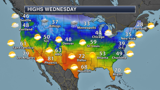
WEDNESDAY: Late day snow showers. High 33. Low 1. Chance of precipitation 20%. Wind W 10-15 mph.
THURSDAY: Cold start to February. High 8. Low -6. Chance of precipitation 0%. Wind NW 10-15 mph.
FRIDAY: Increasing clouds. Overnight snow. High 16. Low 6. Chance of precipitation 30%. Wind SW 5-10 mph.
SATURDAY: Morning snow. Skies slowly clear. High 14. Low -9. Chance of precipitation 40%. Wind NW 5-15 mph.
SUNDAY: Sunny and chilly for “LII”. High 8. Low -1. Chance of precipitation 0%. Wind SW 5-10 mph.
MONDAY: Warmer temperatures. PM clouds. High 18. Low 1. Chance of precipitation 0%. Wind SW 5-10 mph.
TUESDAY: Mix of clouds and sun. High 19. Low 0. Chance of precipitation 10%. Wind NE 3-8 mph.
_______________________________________________
This Day in Weather History
January 31st
1893: The temperature drops 40 degrees in five hours during a blizzard at Park Rapids.
_______________________________________________
Average Temperatures & Precipitation for Minneapolis
January 31st
Average High: 25F (Record: 46F set in 2009)
Average Low: 8F (Record: -27F set in 1887)
Average Precipitation: 0.03″ (Record: 1.16″ set in 1881)
Average Snow: 0.3″ (Record: 6.2″ set in 1908)
_______________________________________________
Sunrise/Sunset Times for Minneapolis
January 31st
Sunrise: 7:33 AM
Sunset: 5:19 PM
*Length Of Day: 9 hours, 45 minutes and 55 seconds
*Daylight Gained Since Yesterday: ~2 minutes and 32 seconds
*Next Sunrise at/before 7:30 AM: February 3rd (7:30 AM)
*Next Sunset at/after 5:30 PM: February 8th (5:31 PM)
_______________________________________________
Minnesota Weather Outlook
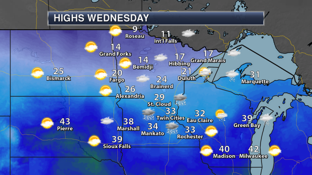
A cold front will sweep through the state for the middle of the week, bringing some light snow shower chances for parts of southern Minnesota Wednesday. Snow totals are not expected to add up to much, however. This cold front will bring in a push of Arctic air to end the week, signs of which we can start to see in northern Minnesota where highs will be in the single digits and teens. Across southern Minnesota (ahead of the push of cold air) highs will still be in the 30s.
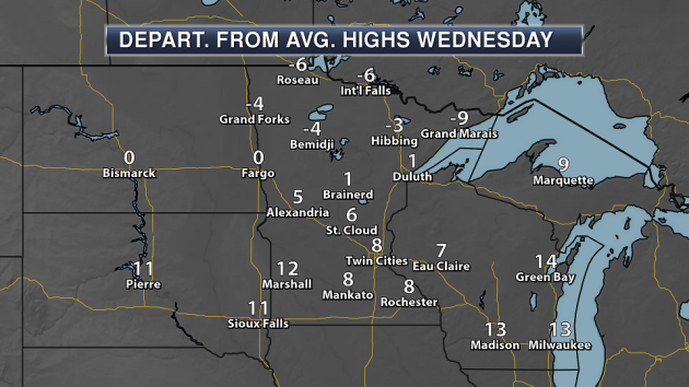
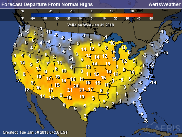
We can see the cold air divide on our departure from average map for Wednesday, as temperatures will be below average across northern Minnesota, but above average over southern Minnesota.
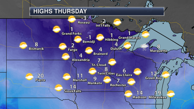
Thursday, however, will be quite a chilly day across the state as highs will be in the single digits above zero in most locations. Across parts of northwest and north-central Minnesota, Thursday highs may not make it above zero. The warmest area of the state will be southwest Minnesota, where some teens will be possible. The good news? No precipitation expected!
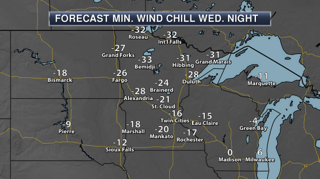
It will be a cold start to Thursday, however, as wind chills will dip into the 20s and 30s below zero across central and northern Minnesota. I would expect at least wind chill advisories to be issued for Wednesday night across parts of the state.
We will see temperatures that are a touch warmer heading into Friday and Saturday in the Twin Cities. Unfortunately, a touch warmer means that highs will only be in the teens. Another push of cold air works in behind a system that will bring some snow Friday Night into Saturday, and highs will be back in the single digits for Super Bowl Sunday. Sunday morning will also be the coldest of the next seven days. Cooler than average weather will continue into next week.
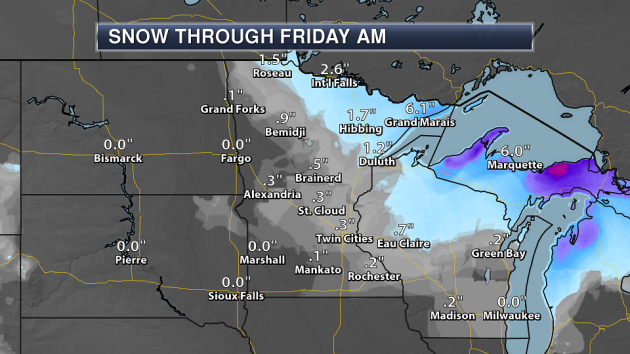
Snow Tuesday night into Wednesday won’t amount to much across central and southern Minnesota, where less than a half an inch of snow is expected. Heavier snow has fallen Tuesday into Tuesday night across northern Minnesota, where parts of the Arrowhead and North Shore could see 3-6″ of snow by Wednesday.
Another chance of snow will move in Friday Night into Saturday, and models (at the moment) are outputting the potential of a couple inches of snow. We’ll keep an eye on that over the next couple days, as the forecast could easily change before then.
_______________________________________________
National Weather Forecast
A cold front moving across the northern U.S. will bring the potential for snow showers from the Northern Rockies into the Great Lakes Wednesday. Rain and snow will also be possible from the Ohio Valley into parts of New England. Some rain and higher elevation snow is also expected to continue across the Pacific Northwest.
We can see the next cold front moving into the northern U.S., with areas of the upper Midwest seeing below average temperatures Wednesday. The East Coast will also see colder than average highs behind a cold front that moved through Tuesday. Most of the rest of the nation will see above average highs.
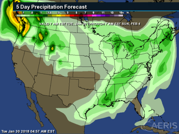
The heaviest precipitation though Sunday morning will be across the Northwest, where continued precipitation chances this week will bring the potential of 2-4″+ of liquid precipitation. A couple storm systems later this week – one to end the week, and another into the weekend, could bring a half an inch to inch or more of liquid precipitation (both in the form of rain and melted snow) to parts of the Eastern United States.
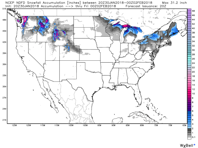
The heaviest snow through Thursday evening will be across portions of the Northwest, where some of the higher elevations – especially in the Cascades – could see a foot or more of snow. Over a foot of snow will also be possible across the upper peninsula of Michigan.
_______________________________________________
Drought Concerns Grow In California
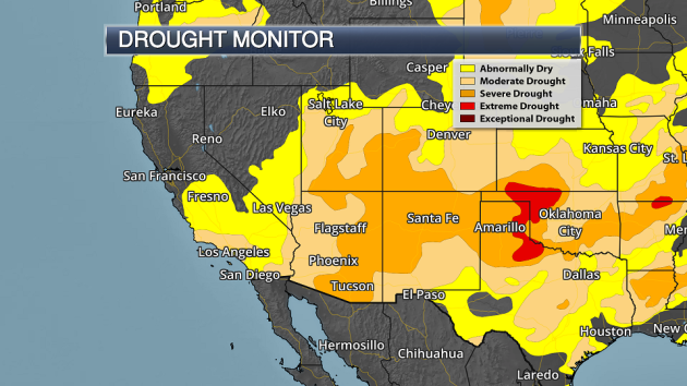
Fears of drought are once again spreading across California as hot and dry weather conditions continue. More from the Los Angeles Times: “The region is in the midst of a heat wave that on Monday brought record high temperatures for the day in places such as Long Beach (91 degrees), UCLA (89), Santa Ana (88), Oxnard (87) and Newport Beach (85). At 93 degrees, Lake Forest was the hottest spot in the United States. More records could fall Tuesday, and there is no rain in the foreseeable future. It’s a repeat of the unusually hot, dry and windy weather that helped fuel huge brush fires in December. Since the end of last February, downtown Los Angeles has seen just 2.26 inches of rain — an anemic amount over an 11-month period. Los Angeles has seen just 28% of its average precipitation since October — with most of it coming from the rainstorm that caused the deadly mudslides in Santa Barbara County.”
Cold, Snow In Tokyo Leads To Record Ambulance Calls
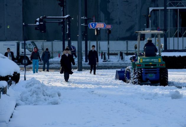
This was last week in Tokyo, as temperatures dropped to 25 degrees (the coldest in 48 years). More from AFP via Yahoo News: “Tokyo’s ambulance service has experienced its busiest day in more than 80 years, officials said Thursday, amid icy conditions as the Japanese capital shivers through its coldest temperatures in decades. The Tokyo fire department, which runs the ambulance service, said it had responded to 2,826 calls on Wednesday following rare and heavy snow that sparked chaos in one of the world’s most populous cities.” (Image: Tokyo residents have been battling through snow and ice as the mercury drops (AFP Photo/Toshifumi KITAMURA))
How Fast Did The EPA’s Website Change?
Did you think the EPA’s site changed quickly after the Trump administration? You’d be correct according to new documents. More from CNN: “The Trump administration took an interest in the content of the Environmental Protection Agency’s website in its first week in office, with Administrator Scott Pruitt eventually directing edits, according to internal documents made public Monday. Pruitt, who took office last February, was personally interested in changes related to the Clean Power Plan, a sweeping greenhouse gas regulation that was a priority of the Obama administration but that Pruitt would eventually announce plans to withdraw. “How close are we to launching this on the website? The Administrator would like it to go up ASAP,” Lincoln Ferguson, an adviser to Pruitt, wrote in early April. “He also has several other changes that need to take place.””
_______________________________________________
Thanks for checking in and have a great Wednesday! Don’t forget to follow me on Twitter (@dkayserwx) and like me on Facebook (Meteorologist D.J. Kayser)!
– D.J. Kayser

