.97″ rain fell yesterday at KMSP.
55 F. maximum temperature yesterday in the Twin Cities.
34 F. average high on November 28.
30 F. high on November 28, 2015.
November 29, 1991: Parts of central Minnesota receive heavy snow including a record 16 inches of snow in New Ulm.
November 29, 1835: A low of 11 below zero is reported at Ft. Snelling.
We Still Can’t Predict Snow Down To The Inch
“Paul, there’s a big discrepancy between your weather app and what you’re publicly predicting. What’s going on?” Welcome to my world.
Apps are great, but they don’t capture all the nuance, variation or challenges with a specific forecast. That’s where the human element comes in: meteorologists add value by adding context, perspective and analysis.
Not even Siri can do that. Yet.
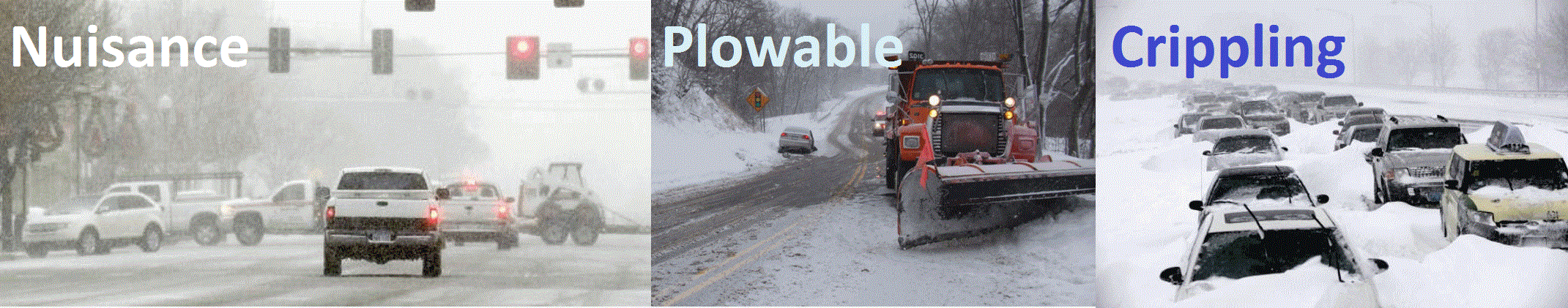
My favorite college professor told us to “forget about inches” and classify storms into 3 categories: nuisance, “plowable” and crippling. I’ve been borrowing the scale since 1983 at KARE-11. It has stood the test of time.
Yesterday’s hail-producing T-storms are long gone; cold exhaust on the backside of the storm sparks a wintry mix into Thursday – a nuisance coating is possible. The coldest air of the season arrives late next week with highs in the 20s.
That’s 20s ABOVE zero.
Some moderation is likely by mid-December as winds blow from the Pacific, not the Arctic.
Any big, meaty storms pass south of Minnesota into next week, but I’m bullish on a white Christmas this year. We are due.
Minnesota Annual Precipitation Record Broken. It’s official; Waseca wins the Golden Rain Gauge Award, with a record 53.78″ of precipitation (and counting). Details from the Minnesota DNR: “Waseca, in south central Minnesota, has set the official state precipitation record, coming in with the highest annual precipitation total for a National Weather Service Cooperative Observation site. As of November 28, 2016 Waseca had a total of 53.78 inches with more precipitation on the way. The old statewide annual record was 53.52 inches of precipitation at St. Francis in Anoka County in 1991…”
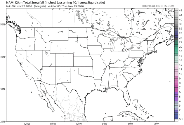
84-Hour Snowfall Potential. This is a product from NOAA’s 12km NAM model, visualized by TropicalTidbits.com. Plowable snows are likely over much of Maine, the Dakotas and the Cascade Range in the Pacific Northwest.
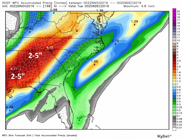
Putting a Dent in the Drought. Here is NOAA WPC’s 7-Day rainfall prediction, showing a potential for 2-5″ from Mississippi and Alabama into northwest Georgia and eastern Tennessee – where many communities haven’t seen a drop of rain in over 40 days. Let’s hope the models verify. Credit: WeatherBell.
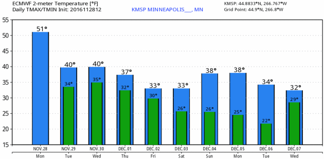
Cooling Back Down To Average. To demonstrate just how spoiled we’ve become “average weather” for late November and early December looks like an unreasonable cold front. ECMWF numbers for KMSP: WeatherBell.

16-Day Weather Map in Motion. Note to self: this is a model, not reality. GFS guidance shows today’s soggy frontal zone pushing across the eastern USA; a series of sloppy slaps for the Pacific Northwest. A more formidable push of Canadian air arrives next week, sparking a soaking from the Gulf Coast into the Ohio Valley, followed by the coldest air of the season for the Midwest and Plains. Source: TropicalTidbits.
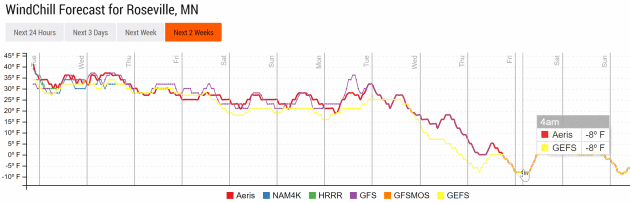
A Real Cold Front Late Next Week? Internal models hint at single digit lows by next Friday morning, December 9, with a wind chill dipping below zero. I don’t think the chill will linger for long, based on the 2-week jet stream outlook from GFS (below). Graphics: Aeris Enterprise.
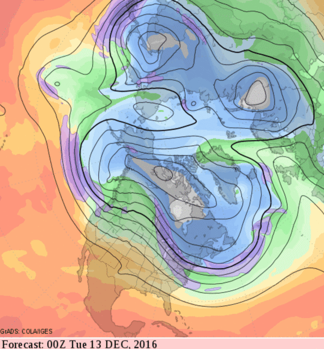
Mid-Month Moderation. GFS guidance is fairly consistent with more of a zonal, west-to-east wind flow returning at 500mb during the second week of December; the coldest lobe of air lifting into Ontario and Quebec.
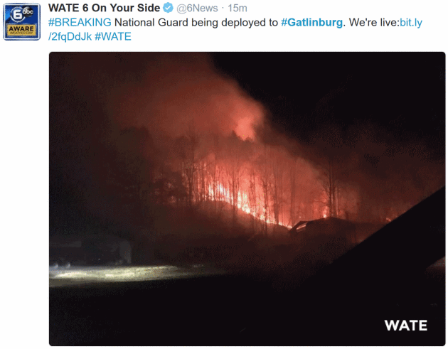
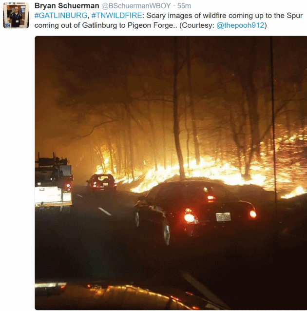

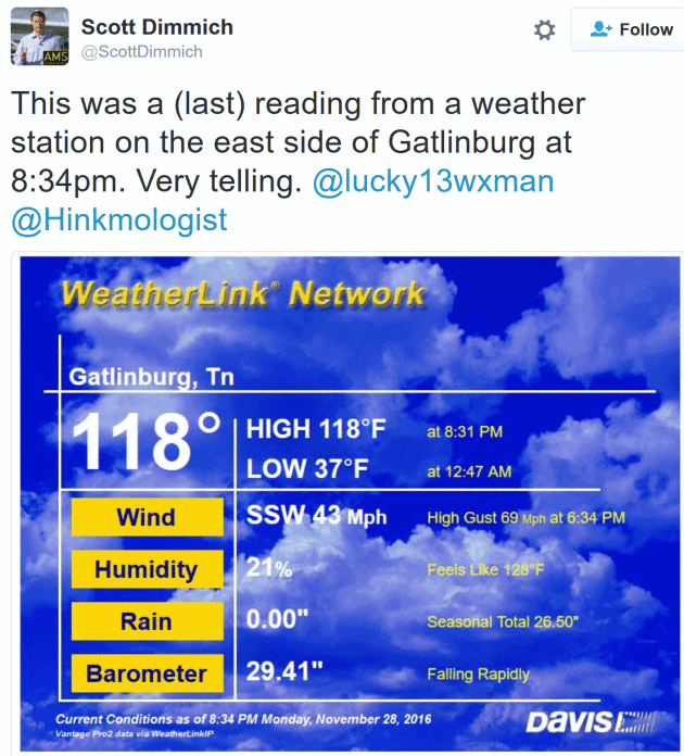
Things I Haven’t Seen Before. Prayers go out to residents of Gatlinburg, Tennessee, where fast-moving evacuations forced the evacuation of the entire city. The images and stories are harrowing; I have never seen a surface temperature of 118F with 69 mph wind gusts fanned by flames. Rain can’t come a moment too soon.

Unusual For November 28. Midday Doppler radar from the Twin Cities Chanhassen office showed a line of strong T-storms pushing across the metro with numerous reports of pea-size (.50″) hail, depicted in yellow on the map above.

“Thunderstorm Asthma”: Deadly Illness Caused By Freak Weather. CNN.com has more on the sequence of weather events that can result in extreme asthma outbreaks, even among people who don’t even realize they have asthma: “…People with hay fever are particularly at risk, Newbigin said. He advised them to “better manage your hay fever during the pollen season,” by using antihistamines, eye drops and other medications. Though normally hay fever occurs in the nasal area, the freak weather conditions which cause thunderstorm asthma can drive the allergens deep into the lungs, causing a far more severe asthmatic attack. “Anybody with severe or brittle asthma (a less common form involving severe but irregular attacks) is most likely to experience severe symptoms and need rapid treatment,” said Sheikh, adding that smog days, pollution and smoking as other environmental triggers for an attack. “They are much less likely to trigger it if there is good underlying asthma control…”
Photo credit above: The Conversation in Australia, which has an explainer on thunderstorm asthma here.
NBC News has more details on “thunderstorm asthma” here.

Thunderstorm Asthma: “You’re Talking An Event Equivalent to a Terrorist Attack. How and why pollen combines with thunderstorms to create these freakish and deadly asthma attacks is still not fully understood. Frequency of these rare outbreaks may be increasing for a variety of reasons, reports The Guardian: “…What is known is that grass pollen is usually too big to get into the lungs to cause asthma, and instead causes a reaction in the superficial respiratory systems of those with pollen sensitivity: a hay fever reaction such as a runny nose, sore throat and itchy eyes are more common. But when a thunderstorm occurs, pollen which had settled during the day can be swept back into the air and the moisture in those winds combined with wind power causes the pollen to rupture into smaller pieces, between 0.5mm and 2.5mm in diameter. Those small fragments are then able to penetrate the superficial respiratory system and get into the lungs, triggering asthma and other serious respiratory responses…”

Thunderstorm-Associated Asthma in Atlanta, Georgia. Meteorologist Marshall Shepherd is among a handful of researchers who delved into this rare phenomenon; here’s an excerpt from their findings: “Associations between thunderstorm activity and asthma morbidity have been reported in numerous locations around the world. The most prominent hypotheses explaining the associations are that pollen grains rupture by osmotic shock in rainwater, releasing allergens, and that gusty winds from thunderstorm downdrafts spread particles and/or aeroallergens, which may ultimately increase the risk of asthma attacks. A full understanding of “thunderstorm asthma” is crucial, especially with projections of increases in heavy rainfall, thunderstorm events and aeroallergen concentrations as the climate system warms...”

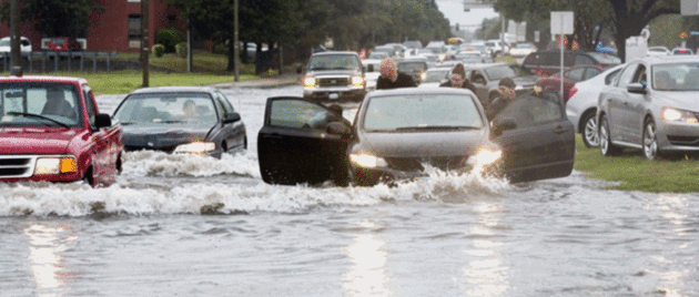
Many 500-Year or 1,000-Year Floods Reported This Year. Here’s a nugget from a story at Weather or Not and CDAPress.com: “It’s almost hard to believe, but areas that are currently reporting major drought conditions experienced massive flooding earlier this year. Normally, we see these huge 500-year or 1,000-year flood events less than once per year. For 2016, there have been nearly a dozen events, which indicates that our cycle of Wide Weather “Extremes” is still going strong with no signs of letting up anytime soon. Most of the big flood events were east of the Rockies. In early June, Houston reported 22 inches of rain, which was a 500-year event. Dallas picked up 16 inches of rain, also a 500-year flood...”
File photo: David Gatley, FEMA.
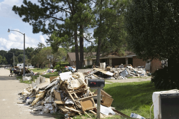
Rebuilding After A Disaster. Builder Online argues that there is a much more efficient way to rebuild after major natural disasters; here’s an excerpt: “…Since flood disasters are similar, Ward says, there should be a plan in place to rebuild communities efficiently and intelligently. “You have to get people back in their houses and we have to have a plan to do that,” he says. “It can’t be reinvented every catastrophic event. Recovery plans are always different.” He wants to do away with the “conventional construction methodology” where each contractor gets simultaneously get hired for jobs in a bunch of different neighborhoods in a given region. Rather than a contractor taking two-to-three hours to install sheetrock in a home, then drive an hour to his next stop, it’d make more sense to have the contractor focus on one neighborhood at a time, he says…”
Photo credit: “The rebuild process in Baton Rouge will most likely take years.”
The Next Fashion Trend: Weather Forecasting. Good luck with that. The fashion industry is getting a taste of climate volatility and weather disruption, as reported at The Wall Street Journal: “…Weather fluctuations have increasingly been putting fashion designers and clothing retailers on the defensive. Merchandise is often ordered months in advance based on what the weather typically is at that time of year. But when temperatures are different from what was predicted—milder-than-usual winters, cold springs or otherwise inconsistent weather—clothes that are all wrong for the climate stay on racks and get discounted, hurting sales. Last winter was the warmest on record for the contiguous U.S., says Jake Crouch, a climate scientist at the National Oceanic and Atmospheric Administration’s National Centers for Environmental Information. The average temperature was 36.8 degrees Fahrenheit, 4.6 degrees above average, with some parts of the country even higher above average. That led to less demand for heavy winter coats...”
Photo credit: “Calvin Williamson, a professor of math in the Fashion Institute of Technology’s School of Liberal Arts, teaches ‘Predictive Analytics for Planning and Forecasting,’ a new class.” Photo: Caitlin Ochs for The Wall Street Journal.

The Future of Oil. The Economist takes a look at a possible inflection point for fossil fuels; here’s a clip: “…Yet the transition from horse power to horsepower, a term coined by Eric Morris of Clemson University, South Carolina, is a useful parable for our time. A hundred years ago oil was seen as an environmental saviour. Now its products are increasingly cast in the same light as horse manure was then: a menace to public health and the environment. For all its staying power, oil may be facing its Model T moment. The danger is not an imminent collapse in demand but the start of a shift in investment strategies away from finding new sources of oil to finding alternatives to it. The immediate catalyst is the global response to climate change. An agreement in Paris last year that offers a 50/50 chance of keeping global warming to less than 2ºC above pre-industrial levels, and perhaps limiting it to 1.5ºC, was seen by some as a declaration of war against fossil fuels...”

Another U.S. City Commits To 100% Renewable Energy. Details via Solar Industry: “The St. Petersburg, Fla., City Council has formally approved the city’s commitment to transition to 100% clean, renewable energy. According to the Sierra Club, St. Petersburg represents the first city in Florida and the 20th city in the U.S. to make such a commitment. In a unanimous vote, the City Council Committee of the Whole has allocated $250,000 of BP settlement funds from the 2010 Deepwater Horizon oil spill to an Integrated Sustainability Action Plan (ISAP), which will chart a roadmap to 100% renewable energy in St. Petersburg…”

Worrying About Getting Older Might Be Worse Than Actually Getting Older. So reports The Washington Post, with a summary of interesting findings: “…Our youth-obsessed culture teaches girls that time zaps their worth, said co-author Anne Barrett, director of FSU’s Pepper Institute on Aging and Public Policy. That “affects not only older women, who are challenged with avoiding ageism,” according to the study, published this month in the Journal of Women and Aging, “but also younger and middle-aged women, who are faced with negative and potentially anxiety-producing images of their possible futures as devalued older women.” Barrett drew this conclusion from the National Survey of Midlife Development in the United States, which seeks to measure how people see themselves over time. The MIDUS data showed that the youngest respondents, 25 to 35, were eight times as likely to report anxiety about declining attractiveness as women in the 66-to-74 bracket. This particular source of aging anxiety, Barrett found, drops with maturity...”

Forget Your Old Alarm System. This Drone Will Protect Your House. CNN.com has details: “…Here’s how it works: The Sunflower Home Awareness System relies on the drone and a handful of in-ground smart lights to watch over your house. It detects motion, vibration and sound. By analyzing this data, the system can distinguish between a human, a car and animals. To do so, it uses artificial intelligence to identify the disturbance and determine if it’s potentially dangerous. For example, trusted visitors such as mail delivery persons will be recognized by how they approach the home and how long they stand at the front door…”

The Only Way to Commute in 2025? Check out the concept vehicle from Terrafugia, a car that transitions into a 4-seat, hybrid VTOL (vertical take-off and landing) airplane. These won’t come cheap, and they’re still 8-12 years away, but wow. I hope it’s real. When I imagined the 21st century it came with flying cars – we seem to be inching closer to that vision. Here are more details and a mind-blowing YouTube video: “Terrafugia is excited to premier the new Outer Mold Line for the TF-X™, Terrafugia’s vision for the future of personal transportation. The TF-X™ will be a four-seat, vertical takeoff and landing (VTOL) hybrid electric aircraft that makes flying easier and safer than ever before. Visit terrafugia.com for more information.”

TODAY: Gray with a shower or sprinkle. Winds: SW 10-15. High: 41
TUESDAY NIGHT: Few showers, mixed with snow at times. Low: 34
WEDNESDAY: Light rain-snow mix. Slushy coating by nightfall? Winds: NW 5-10. High: 39
THURSDAY: Light mix tapers to flurries. Winds: NW 10-15. Wake-up: 31. High: 37
FRIDAY: Mostly cloudy, few flakes around. Winds: NW 8-13. Wake-up: 30. High: 36
SATURDAY: Peeks of sun, good travel day. Winds: S 7-12. Wake-up: 27. High: 38
SUNDAY: Mostly cloudy, risk of a flurry. Winds: E 7-12. Wake-up: 26. High: 39
MONDAY: Mostly cloudy, temps. close to normal. Winds: NW 7-12. Wake-up: 29. High: 38
Climate Stories…

America’s Coastal Cities Don’t Have to Drown, Dutch Experience Shows. Here’s an excerpt of a sobering article at Honolulu’s Star-Advertiser: “…Olsen says there is no simple and one-size-fits-all solution to the problems that sea level rise will bring. There is no way the United States will be able to surround all of its cities with sea walls. “The United States is just too big. There’s too much coastline,” he says. The U.S. has about 12,000 miles of ocean and sea coastline. By comparison, the Netherlands protects 270 miles of seacoast. The American reality is that some cities will probably be sacrificed. Parts of cities certainly will be sacrificed. “The U.S. coasts will look very different in 50 years,” Olsen says. “We’re going to have to learn to be like Venice, to learn to live with water…” (File photo credit: Andrew Demp, Yale).
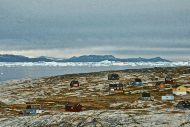
Unchecked Arctic Melting: How Some Communities Are Starting to Adapt. Here’s an excerpt from Christian Science Monitor: “The Arctic ecosystem may be heading toward permanent change as high temperatures and longer summers continue to alter the region, according to a report published by the Arctic Council on Friday. In the first comprehensive assessment of ecosystems and societies in the region, the Arctic Resilience Report highlights how human activities and global warming may have caused some ecosystems to reach key tipping points, thus threatening the way of life and economies of local communities…”
Photo credit: “An Inuit village in Greenland is pictured in this September 2013 handout photo provided by Ida Moltke. New research by the Arctic Council shows how unprecedented high temperatures and rapid ice melt in the Arctic are driving communities to tipping points of survival.” Ida Moltke/Handout/Reuters/File.
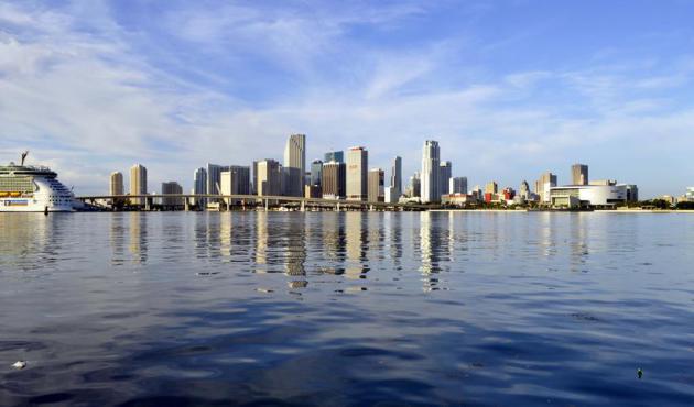
Sand’s End. The seas are rising. That’s not a climate model, but based on observations. And that has implications for hundreds of millions of people around the planet. Here’s an excerpt of an article from MSN.com: “…For years the sea has been eating away at the shore, and the city has spent millions of dollars pumping up sand from the seafloor to replace it, only to have it wash away again. Every handful of sand on Miami Beach was placed there by someone. That sand is washing away ever faster. The sea around Miami is rising a third of an inch a year, and it’s accelerating. The region is far from alone in its predicament, or in its response to an eroding coast: it’s becoming hard to find a populated beach in the United States that doesn’t require regular infusions of sand, says Rob Young, director of the Program for the Study of Developed Shorelines at Western Carolina University. Virginia Beach, North Carolina’s Outer Banks, New York’s Long Island, New Jersey’s Cape May, and countless other coastal cities are trapped in the same cycle, a cycle whose pace will become harder to maintain as the ocean rises…”
Photo credit: Wikipedia.
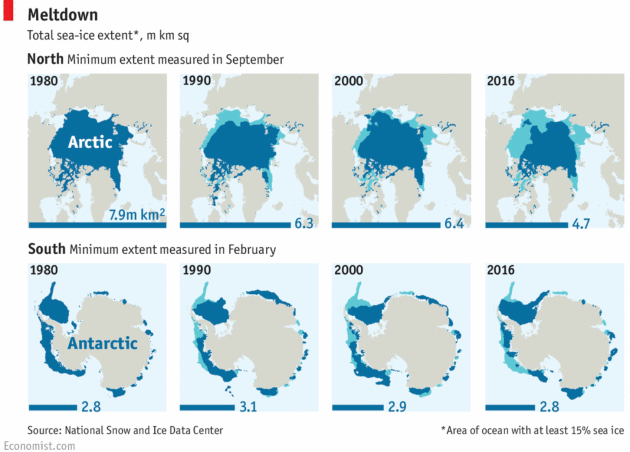
Sea Ice Reaches A New Low. Here’s an excerpt from The Economist: “…Scientists are interested in sea ice as a marker—and amplifier—of climate change. Its bright surface reflects 80% of the sunlight that hits it back into space. When it melts, the uncovered dark ocean surface absorbs 90% of the sunlight, which heats it up, causing more ice to melt. In recent years, the melting season in the Arctic has been ending later in the year, leading to less time for new ice to form. As a consequence, the total sea-ice extent in September 2016 was over 3m km² smaller than in September 1980, although not as small as in September 2012, the worst year on record…”
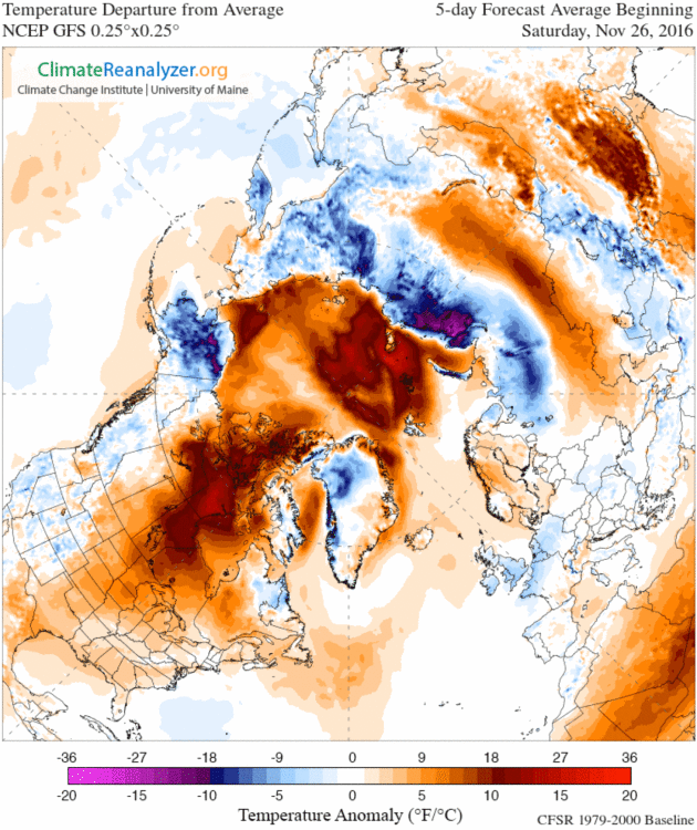
Arctic Ice Melt Could Trigger Uncontrollable Climate Change at Global Level. Are we close to a tipping point in the Arctic? Here’s an excerpt from The Guardian: “Arctic scientists have warned that the increasingly rapid melting of the ice cap risks triggering 19 “tipping points” in the region that could have catastrophic consequences around the globe. The Arctic Resilience Report found that the effects of Arctic warming could be felt as far away as the Indian Ocean, in a stark warning that changes in the region could cause uncontrollable climate change at a global level. Temperatures in the Arctic are currently about 20C above what would be expected for the time of year, which scientists describe as “off the charts”. Sea ice is at the lowest extent ever recorded for the time of year...”
5-Day Predicted Temperature Anomalies: Climate Reanalyzer.
