65 F. high temperature in the Twin Cities Tuesday.
49 F. average high on March 31.
58 F. high reported on March 31, 2014.
.45″ rain predicted this evening and tonight (NAM model)
82 F. record high for April 1 (set in 1882).
Lukewarm & Loud
“The weather is here, wish you were beautiful!” Thanks Dad. I wish my 84-year old father would stop sending me postcards.
“You must be popular today” a bank teller gushed yesterday. It’ll pass, I replied.
But the older I get the more I force myself to savor the good times. Being in the moment, right? Hold on. I think I can photograph this springy sky with my smartphone as soon as I answer this text and respond to 213 e-mails in my in-box.
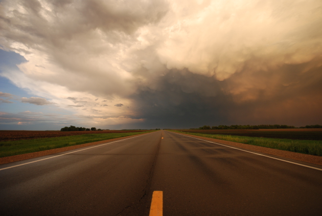
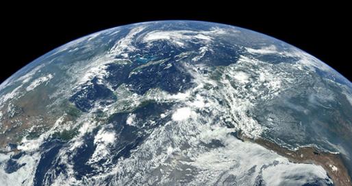
Do yourself a favor: take a mental health break and sneak outside today, as we enjoy the warmest day since the mercury hit 72 degrees on October 16, 2014. Long-lost neighbors will emerge from hibernation, squinting up at the sun.
The atmosphere overhead may be unstable enough to spawn a few cauliflower clouds by the dinner hour – thunderheads capable of small hail and gusty winds. The threat of severe weather is greatest south of MSP. NOAA’s NAM model prints out over half an inch of rain tonight. I’m skeptical but I hope it’s right.
We cool off later in the week, in fact brisk sweatshirt weather lingers into next week, with a better chance of rain Monday and Tuesday – possibly mixed with slushy snow up north.
Don’t write off winter just yet. Sorry.
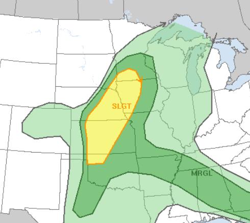
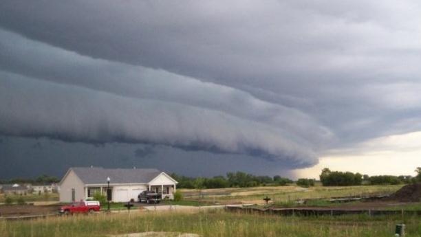
Slight Severe T-storm Risk. Instability, wind shear and low-level moisture is most favorable for a few (isolated) severe cells over southwestern Minnesota, generally south and west of a line from Mankato to Willmar. T-storms may push into the Twin Cities by late afternoon or evening, after temperatures reach the low to mid 70s. Map: NOAA SPC.
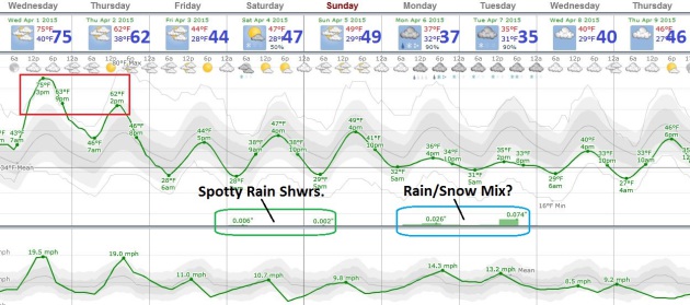
Another Relapse. After a May-like temperature swoon today temperatures cool off later this week, a taste of early March shaping up for early next week with readings struggling to reach 40F Monday and Tuesday. European guidance is even hinting at a rain/snow mix, especially north of the Twin Cities. Don’t rule out more slush before the daffodils arrive.
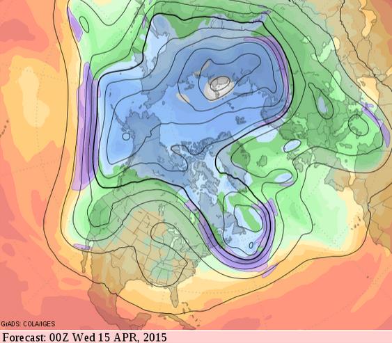
Mellowing Trend by Mid-April. Next week looks chilly across the Upper Midwest and northern tier states in general, but GFS guidance from NOAA shows the core of the jet stream lifting north the second week of April; highs in the 50s and 60s are likely again by mid-month. The reality: the sun is too high in the sky for it to stay cold for long. Map: GrADS:COLA/IGES.

Surprising Research About Weather And Your Mood. Here’s a snippet from a story at About Health: “…The commonly held belief that sunny bright days and pleasant weather generally makes people happier was not supported by this research. It was determined that temperature, wind and level of sunlight had a significant effect on negative mood. Sunlight also seemed to have an effect on participants’ energy level. The authors speculated that sunlight’s effects on tiredness may have something to do with Vitamin D3, which is indicated in the production of serotonin. Serotonin is a neurotransmitter that is involved with mood and level of energy…”
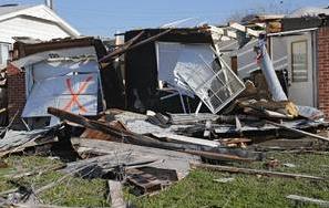
Moore Tornado Upgraded To EF-2 Rating. News OK has the update; here’s an excerpt: “A tornado that struck Moore last week was upgraded to an EF2 rating, the National Weather Service reported. Forecasters gave the tornado a preliminary rating of EF1 last week. But a tornado survey team spotted a small amount of damage consistent with an EF2 tornado between NW 2 and Arnold Street to Main Street and Janeway Avenue, forecasters said…”
Photo credit above: “Storm damage to a home in Moore, Okla. on Thursday, March 26, 2015. A tornado hit the area on Wednesday evening causing damage in the area.” Photo by Chris Landsberger, The Oklahoman.
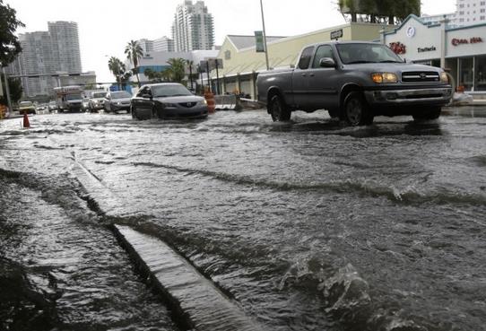
Massachusetts Seeks Disaster Aid For Snow. AP and The Denver Post have the details; here’s the introduction: “Massachusetts will seek a federal disaster declaration for the record-setting snowstorms that wreaked havoc on the state and piled up what state officials estimate to be $400 million in snow removal costs and other damage, Gov. Charlie Baker’s administration said Tuesday. Baker planned to send a letter to President Barack Obama by the end of the week asking for the disaster declaration for 10 counties, an area encompassing about 250 cities and towns, a spokesman told The Associated Press…”
Photo credit: Michael Dwyer, AP.

Hurricane Scholar Klotzbach Hints At Below Average Hurricane Season. My confidence in long-range hurricane prediction is remarkably low, but on paper, with a strengthening El Nino and a stronger southerly branch to the jet stream, a less active hurricane season in 2015 seems like a smart bet. Then again, all it takes is one. Here’s an excerpt from PalmBeachPost.com: “A hint that this year’s hurricane season will be below average came Tuesday from Phil Klotzbach, half of the well-known Colorado State University prognostication team. “it’s looking like it’s going to be a pretty boring year for us,” Klotzbach said at a session at the National Hurricane Conference, meeting this week in Austin, Texas. The team issues its official forecast April 9...”
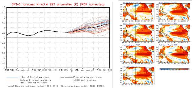
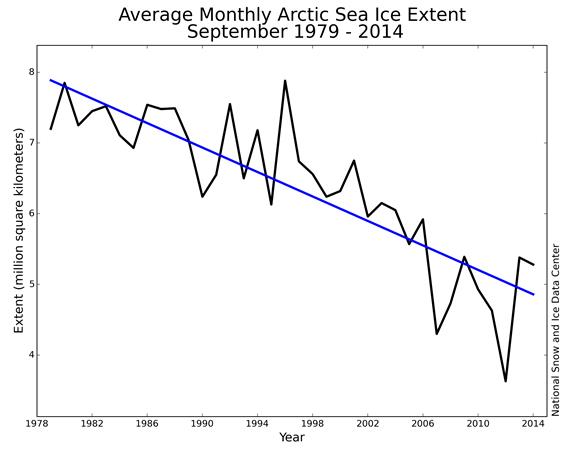
More Significant El Nino Brewing? Every update from NOAA CPC looks more impressive for scope and duration of warming from a warm phase in the Pacific Ocean. Latest forecasts suggest sea surface temperature anomalies as much as 1-2F warmer than average by the winter months.
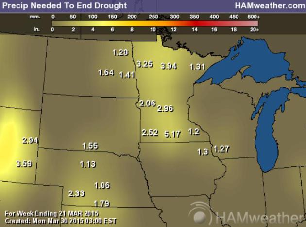
Moderate Drought. As much as 2-5″ of rain is required to pull out of a deepening drought. At last report over 88% of Minnesota was in moderate drought; 99% of the state abnormally dry. Source: NOAA and HAMweather.
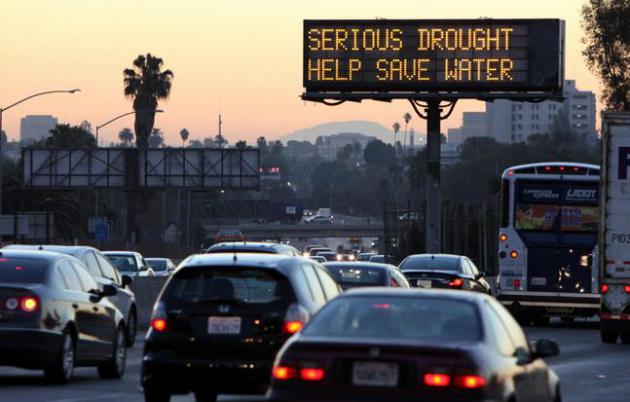
California Drought Goes From Bad to Worse As State Grapples With Heat Wave. The Guardian has details; here’s a clip: “…Experts say the scorching spring days are part of a long-term warming pattern – driven largely by human activity – that is increasing the chances that future droughts will be as bad as this one. At fault is a warm and dry weather combination, which exacerbates the already dire drought conditions by drying soil, melting snow and driving up water usage. “It’s like a one-two punch,” said Jeanine Jones, deputy drought manager for the state Department of Water Resources (DWR). “Not having enough water to fill our reservoirs and having the hot weather evaporate the little that we do have…”
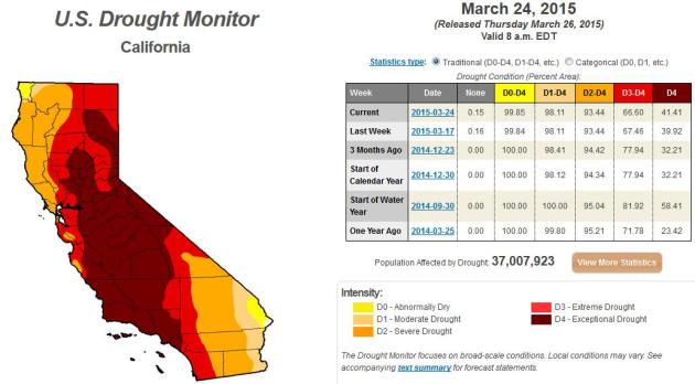
* Latest U.S. Drought Monitor for California is here.
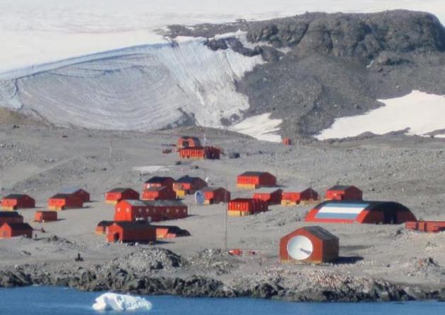
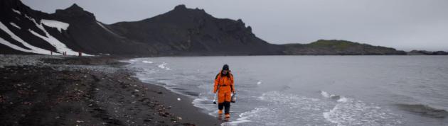
Possible New Continental Heat Record for Antarctica. Christopher Burt has the story at Weather Underground; here’s an excerpt and link: “On March 24th Base Esperanza (under Argentinean administration) located near the northern tip of the Antarctic Peninsula reported a temperature of 17.5°C (63.5°F). Although this is the warmest temperature ever measured since weather stations became established on the southern continent, it is complicated by what the very definition of ‘Antarctica’ is. Here’s a brief review…”
Image credit: “Argentina’s Esperanza Base on the northern tip of the Antarctic Peninsula. It is located near 63°S latitude.” Image from Wikipedia.
It Was Warmer In Antarctica Than New York City Last Week – And That’s Not Even The Bad News. VICE News takes a look at what potentially record warmth in Antarctica really means; here’s an excerpt: “…While scientists warn not to draw conclusions from a single weather event, the temperature record hues closely to more alarming, long-term trends in the southern continent. Antarctica’s floating ice shelves have recently decreased by as much as 18 percent in some spots over the last 18 years, says a new study, published in the journal Science. As the oceans have warmed, they’ve spurred more of the frozen mass to become water, researcher Fernando Paolo told VICE News...”
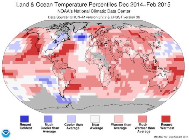
A Hypothesis About The Cold Winter In Eastern North America. Could a slow-down in the North Atlantic circulation, triggered by rapid melting of (fresh) water from Greenland be responsible for the jet stream dips that have brought unusually cold weather to the eastern USA the past few winters, while the rest of the northern hemisphere experienced unusual warmth? Here’s an excerpt of a post at Real Climate: “The past winter was globally the warmest on record. At the same time it set a new cold record in the subpolar North Atlantic – and it was very cold in the eastern parts of North America. Are these things related? Two weeks ago NOAA published the following map of temperature anomalies for the past December-January-February (i.e. the Northern Hemisphere winter). One week ago, we published a paper in Nature Climate Change (which had been in the works for a few years) arguing that the cold in the subpolar North Atlantic is indicative of an AMOC slowdown…” (Image credit above: NOAA).
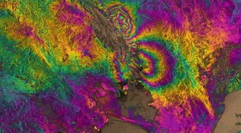
Satellite Data Reveals Earthquake Impact Within 24 Hours. Gizmag has the story; here’s the introduction: “Researchers from the University of Iowa and United States Geographical Survey (USGS) have developed a method of using satellite and GPS data to characterize earthquake fault lines in real time, helping to deliver aid more accurately and with greater speed than current systems allow…”
Image credit above: “The technique uses satellite radar imagery to observe ground displacement, giving researchers rapid insights into the impact of earthquakes.” (Image: ESA/University of Iowa).
Two weeks ago NOAA published the following map of temperature anomalies for the past December-January-February (i.e. the Northern Hemisphere winter). One week ago, we published a paper in Nature Climate Change (which had been in the works for a few years) arguing that the cold in the subpolar North Atlantic is indicative of an AMOC slowdown (as discussed in my last post).
– See more at: http://www.realclimate.org/index.php/archives/2015/03/a-hypothesis-about-the-cold-winter-in-eastern-north-america/#sthash.LPZr0qKX.dpuf

The Science Of Why You Should Spend Your Money on Experiences, Not Things. Co.EXIST manages to successfully summarize why the thrill of material possessions only lasts so long, unlike a great vacation, which you can be talking about for a lifetime: “…There’s a very logical assumption that most people make when spending their money: that because a physical object will last longer, it will make us happier for a longer time than a one-off experience like a concert or vacation. According to recent research, it turns out that assumption is completely wrong. “One of the enemies of happiness is adaptation,” says Dr. Thomas Gilovich, a psychology professor at Cornell University who has been studying the question of money and happiness for over two decades…”
* Is The Definition of Adulthood Changing for Millenials? The Guardian has the story.
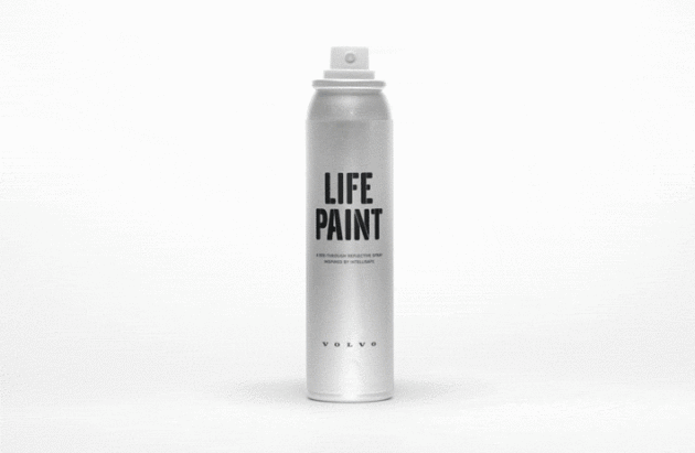
Volvo Designed a Reflective Spraypaint To Make Cycling Safer at Night. The Verge has an interesting story (for anyone who wants to stay safer while cycling); here’s an excerpt: “Volvo is turning its attention to two-wheeled safety, for the moment. The Swedish car manufacturer and UK design firm Grey London have partnered with Albedo100 to create a reflective spraypaint that’s only visible at night. It’s called LifePaint, but it’s technically not paint; it’s a washable material that lasts about 10 days after application. It’s also completely invisible until it’s hit by the glare of a car’s headlights — then it glows...”

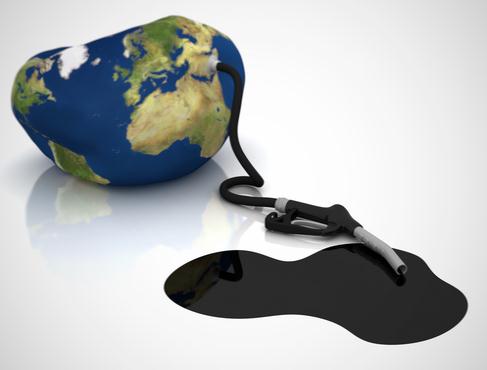
One Million Green Jobs Projected by 2030 in China, EU and U.S. – Experts. Reuters has the article; here’s the introduction: “Nearly one million new “green jobs” are expected to be created in China, the United States and the European Union by 2030 if the regions stick to their current pledges to curb global warming, scientists said on Tuesday. The three regions combined produce more than half the world’s greenhouse gas emissions, according to the U.S. Environmental Protection Agency (EPA), so their policies are crucial for shaping a new global climate agreement to be finalised at a U.N. conference in Paris in December...”

The War On Potholes Has A New Weapon. Yes, we can do some serious beta-testing here in Minnesota. Smithsonian.com has the article; here’s an excerpt: “...I mean, we have driverless cars, but every spring our roads still crumble like stale cake. The best we can manage, it seems, is a mad scramble of patching, little more than a blitz of damage control. But there may be hope for a more proactive pothole strategy. A team of scientists at Northeastern University in Boston has created a special van with sensors, microphones and cameras that not only can detect every crack in a street, but also has ground-penetrating radar to pinpoint where holes are likely to form in the future…”
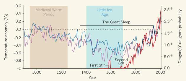
Zoology: Here Be Dragons. Apparently a warming atmosphere and oceans breed conditions that are much more favorable for the formation of dragons, according to a new and controversial paper at Nature. Just what I want to hear on the 1st day of April: “Emerging evidence indicates that dragons can no longer be dismissed as creatures of legend and fantasy, and that anthropogenic effects on the world’s climate may inadvertently be paving the way for the resurgence of these beasts.”
Image credit above: “The relative frequency of ‘dragons’ in fictional literature (thick red line), as determined as a unigram probability4, with two historical reconstructions of Northern Hemisphere temperature (decadal smoothing) shown in blue5 and purple6. Global temperatures have been measured since 1855 (thick black line5). Temperature anomalies represent deviations from the 1961–90 reference period. The rising incidence of dragons in the literature correlates with rising temperatures, and suggests that these fire-breathing lizards are being sighted more frequently. As a result, the large-scale ‘Third Stir’ is deemed to be imminent.”
TODAY: Fading sun, windy and warm, late-day T-storms. Winds: S 20-35. High: 73
WEDNESDAY NIGHT: Showers and T-storms, locally heavy rain possible. Low: 45
THURSDAY: Mostly cloudy, cooler breeze kicks in. High: near 60
FRIDAY: Intervals of sun, brisk for April. Wake-up: 31. High: 47
SATURDAY: Patchy clouds, isolated shower. Wake-up: 30. High: 46
SUNDAY: Lingering clouds, still raw. Wake-up: 33. High: 49
MONDAY: Cold rain develops. Wake-up: 35. High: 45
TUESDAY: Heavier rain possible, still chilly. Wake-up: 36. High: near 50
Climate Stories….


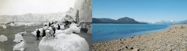
Before And After Glacier Photos Show Devastating Climate Change Effects. Glaciers react to longer term swings in temperature trends – the vast majority of the world’s glaciers continue to melt and Alaska is ground zero. Here’s an excerpt of a story at weather.com: “In the past 50 years, Alaska’s average annual temperature has increased at a rate more than twice that of the rest of the United States. Temperatures at Alaska’s Glacier Bay National Park and Preserve are now 5 degrees warmer than previous averages, Glacier Bay’s website reports. The warming climate has a major effect on the park’s famous glaciers. There are more than 100,000 glaciers in Alaksa, and 95 percent of them are thinning, stagnating or retreating. Muir Glacier in Glacier Bay National Park thinned more than 700 feet in the 23 years between 1980 and 2003...”
Photo credit upper left: “A photo taken from the Muir Inlet in Glacier Bay National Park and Preserve, Alaska between the 1880s and 1890s, shows the 328-foot-high terminus of the glacier and numerous icebergs, some more than 6 feet in diameter.” (Glacier Bay National Park and Preserve Archive).
Photo credit upper right: “A northwest looking photograph taken from the same location in 2005 shows that the Muir Glacier has retreated more than 31 miles and is completely out of the field of view. The glacier in the background to the right is Riggs Glacier. Abundant vegetation is visible.” (Bruce F. Molnia/USGS).
