Wednesday Night/Thursday Snow Totals
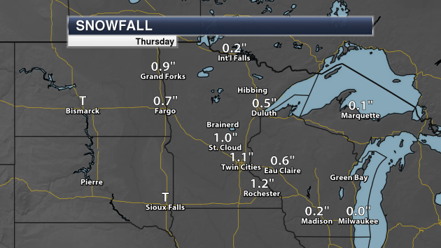
The snow that snarled traffic across the Twin Cities Thursday only accumulated to 1.1″ officially at the airport. Snow totals of at least one inch were also recorded at St. Cloud and Rochester.

The highest total in the Twin Cities National Weather Service office area as of mid-Thursday afternoon was 2.5″ in Dawson. Above are all the 1.5″+ totals reported through 2:18 PM Thursday to the Twin Cities weather service office.
_______________________________________________
Polar Pain: Coldest New Year’s Eve Since 1973?
By Paul Douglas
There is nothing democratic about weather. All storms are NOT created equal. Thursday’s alleged “storm” was a vivid reminder that an inch of snow at 7F is icier and more dangerous than an inch of snow at 25F. Salt doesn’t work nearly as well when it’s Nanook outside.
It’s just too cold to snow (much) and I still don’t see any snowblower-worthy events through mid-January. Steering winds aloft need to blow from New Mexico to get serious moisture into Minnesota; that won’t happen anytime soon.
We just enjoyed the coldest Christmas since 1996. According to Pete Boulay at the Minnesota DNR, if Sunday’s high is colder than -2F in the MSP metro it will be the coldest New Year’s Eve since 1973. Weekend temperatures probably won’t climb above 0F statewide, even colder than the shot a few days ago. The coldest smack of the winter? Probably, although January may not be much better.
So the much-publicized Polar Vortex will pay us a visit, but will it stall, like it did 4 winters ago? Too early to say. I still see a run of 20s, even 32F by the second week of January. Sweet relief!
_______________________________________________
Extended Twin Cities Forecast
FRIDAY: Light snow, slick roads. High 4. Low -11. Chance of precipitation 50%. Wind NW 5-10 mph.
SATURDAY: Brittle sunlight. Feels like -30F. High -4. Low -14. Chance of precipitation 10%. Wind NW 10-15 mph.
SUNDAY: Numb. Risk of frostbite & hypothermia. High -3. Low -16. Chance of precipitation 10%. Wind NW 8-13 mph.
MONDAY: Sunny, still bitter out there. High 3. Low -6. Chance of precipitation 10%. Wind W 5-10 mph.
TUESDAY: Clouds increase, “milder”. High 13. Low -3. Chance of precipitation 20%. Wind SW 8-13 mph.
WEDNESDAY: Another shot, feels like -25F. High 2. Low -10. Chance of precipitation 30%. Wind N 10-15 mph.
THURSDAY: Clipper possible, light snow risk. High 6. Low -5. Chance of precipitation 40%. Wind S 5-10 mph.
_______________________________________________
This Day in Weather History
December 29th
1999: Minneapolis soars to a high temperature of 53 degrees.
_______________________________________________
Average Temperatures & Precipitation for Minneapolis
December 29th
Average High: 24F (Record: 53F set in 1999)
Average Low: 9F (Record: -24F set in 1917)
Average Precipitation: 0.03″ (Record: 0.80″ set in 1972)
Average Snow: 4.4″ (Record: 6.5″ set in 1889)
_______________________________________________
Sunrise/Sunset Times for Minneapolis
December 29th
Sunrise: 7:50 AM
Sunset: 4:39 PM
*Length Of Day: 8 hours, 48 minutes and 50 seconds
*Daylight Gained Since Yesterday: ~0 minutes and 36 seconds
*Latest Sunrise: December 30th-January 5th (7:51 AM)
*Next Sunset at/after 5 PM: January 17th (5:00 PM)
_______________________________________________
Minnesota Weather Outlook
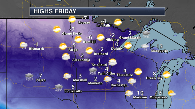
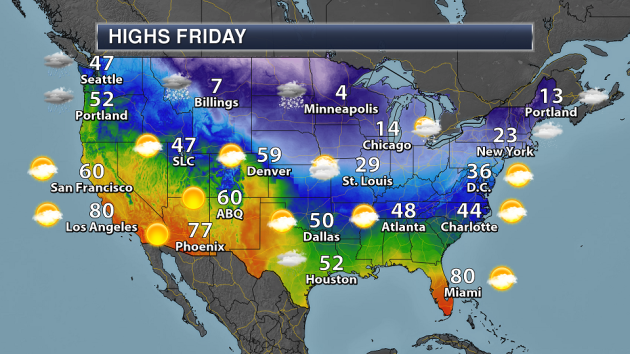
We fall back into the deep freeze starting Friday here across Minnesota, as temperatures back in the single digits across southern Minnesota with the chance of some more snow. The coldest weather Friday will be across northwestern Minnesota, where highs will only climb into the middle single digits below zero.
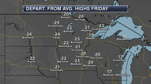
Yeah, I shouldn’t have to tell you this, but highs Friday will continue to be below average for this time of year – by a good 20-25 degrees across much of the state.
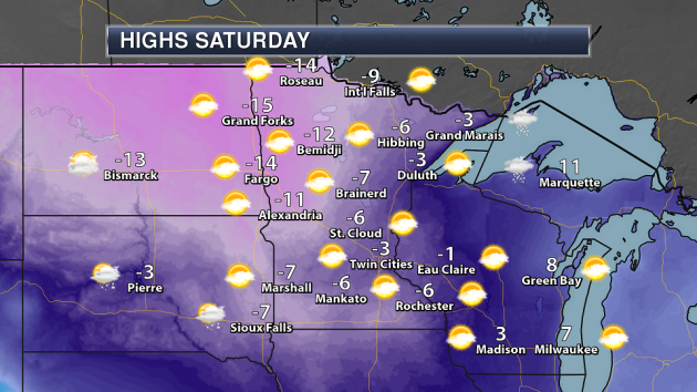
Our deep freeze continues into the weekend as well. Highs won’t make it above zero across the state Saturday, with some areas of northern Minnesota stuck with highs in the teens below zero.

The last day of 2017 Sunday will bring highs below zero once again, but there will be some moderation across parts of the state. Highs in Alexandria and Bemidji will at least make it into the single digits below zero unlike Saturday!

As you can probably already tell by the highs Sunday, it is not going to be a warm start to the New Year across the state. If you are heading out Sunday night to celebrate you’ll need to defend against the cold as temperatures will be in the teens and 20s below zeros across most of the state. The good news? We shouldn’t have to worry about precipitation.
I do have some good news – we will have a good ol’ Minnesota winter tropical heatwave as we head into the first week of 2018! Highs Monday will climb into the single digits above zero in the Twin Cities, with temperatures touching the teens at times next week as well.
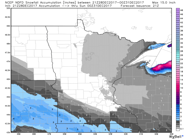
After today’s snow across the region, another system will move across southern Minnesota into Iowa Friday, bringing the potential of more accumulating snow. Snow total are expected to top 3″ in parts of southwestern Minnesota.
After we get through the snow to end the week, our first accumulating snow chance of 2018 looks to occur toward the middle to end of next week.
_______________________________________________
National Weather Outlook
The Northwest will continue to see rain and snow across the region Friday, with totals quickly adding up in spots. A system will help bring some snow to parts of the upper Midwest, meanwhile lake effect snow will ramp up across the lower Great Lakes.
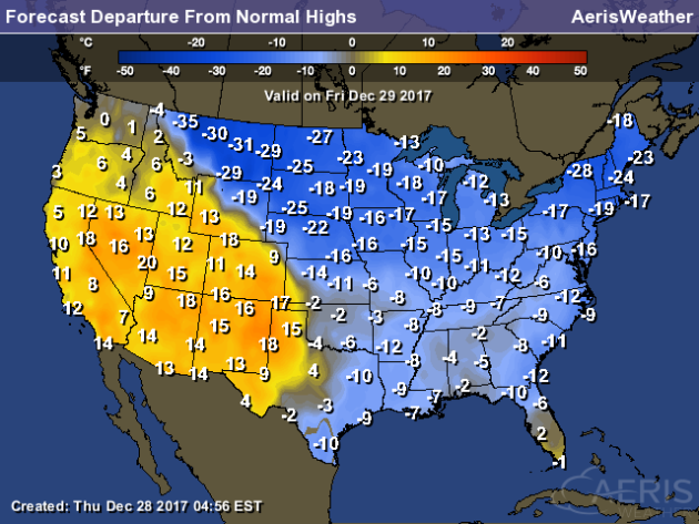
Temperatures will be cold once again from Montana to the central and eastern United States Friday, with highs that are (in some ares) far below average for this time of year. If you want warmth, head out toward the Four Corners and Great Basin, where highs will be up to 20 degrees above average.
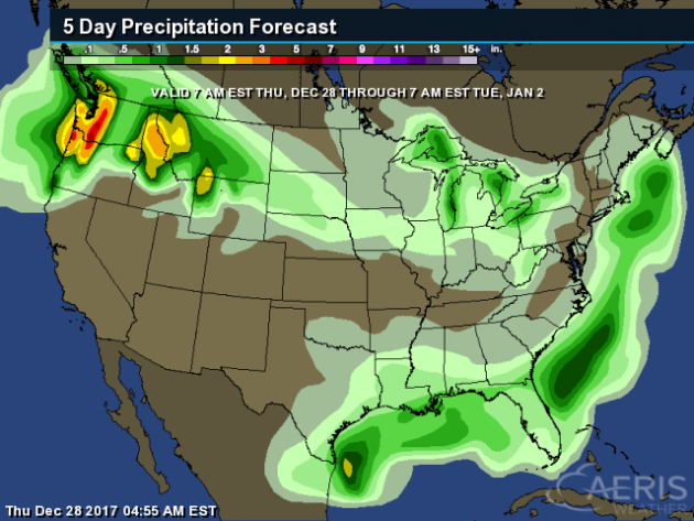
The heaviest precipitation over the next five days (through next Tuesday morning) will be across parts of the Northwest, with a couple systems expected to impact the region through the end of this week.
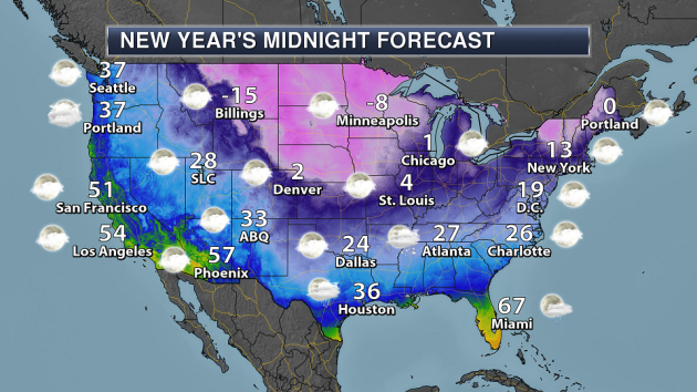
Here’s a look at the New Year’s Midnight forecast across the country if you are planning on heading out and celebrating the start of 2018. It’ll be chilly across a good portion of the county, with temperatures below zero into parts of Nebraska and Iowa. In New York City for the ball drop, temperatures will be in the low to mid teens.
If we saw that temperature of 13° in New York City at midnight Sunday Night, it would be the third coldest ball drop in Central Park observation history (going back to 1907).
_______________________________________________
Sneakers Instead Of Cleats For Pinstripe Bowl
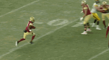
The Pinstripe Bowl Wednesday Night at Yankee Stadium was so cold that players were using sneakers on the field instead of cleats. More from SBNation: “With a kickoff temperature in the 20s and a wind chill even colder than that, it’s not exactly a balmy evening in the Bronx for the Pinstripe Bowl. Both of these teams are used to playing in the cold, but they’re not used to playing on natural grass in these temperatures as both teams have home stadiums with artificial turf. Yankee Stadium doesn’t have an artificial surface, and that’s a bit of an issue.” (GIF: SBNation/ESPN)
Red Rocks New Year’s Eve Concert Moving Due To Cold Weather
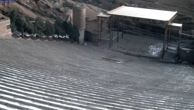
Frigid weather is making the first-ever New Year’s Eve concert at Red Rocks in Colorado relocate. More from CBS Denver: “Fey almost made history with New Year’s Eve on the Rocks. The multi-artist hip-hop show would’ve been the venue’s first-ever concert on Dec. 31st. Due to the bitter cold forecast, Migos, Post Malone and Young Thug will take the stage at Magness Arena instead. “It was a tough decision for us. It was for the safety and comfort and convenience of our fans. There’s nothing better than making sure that your fans are safe and have access to transportation,” said Fey. “With Red Rocks, we were worried about the roads. It’s predicted to be 13 degrees outside and that’s not okay for 4+ hours.”” Image: View from the Red Rocks webcam Thursday morning.
Keeping Pets Warm In The Cold Weather
Good advice with the dropping temperatures across the country over the next few days from the USA Today: “Frosty weather can be dangerous for pets, particularly smaller dogs or ones with lighter fur, veterinarian Ashley Levinson said. “The thinner the coat, the more hair-like the coat, the more exposed they are to the cold in general,” said Levinson, who works at the Bergen County Veterinary Center. Dog owners can help protect their pets by bundling them up and keeping an eye on their behavior — if a pet is at the door and wants to come back inside, the owner should let him come in and warm up, Levinson said.”
The Response For Cold Weather Climate Change Deniers
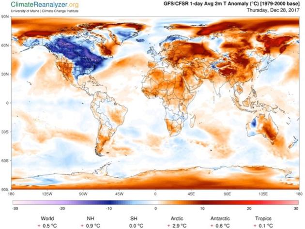
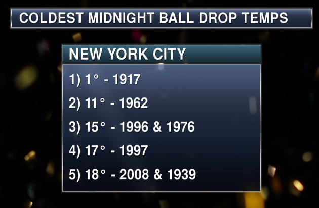
When it gets cold, do you ever hear people say “so much for global warming?” Professor of meteorology at the University of Georgia Marshall Shepherd has the response he uses when people say that over at Forbes: “If you are reading or watching the news, winter weather is the current headline. Negative wind chills, feet of lake effect snow in the Great Lakes region, and possibly the coldest New Year’s Eve ball drop in almost a half century are on tap. Forecasts are suggesting that temperatures will be in the teens and wind chills below 0 deg F as the famed ball descends from the New York City skyline. The top 3 coldest temperatures were: 1 degree F in 1917, 11 degrees in 1962, and 15 degrees in 1976/1996, respectively. Like clockwork, you will also start seeing tweets and posts refuting climate change even though 2017 will end as one of the top 3 warmest years on record. It is very common to see statements like”those climate scientists are full of it, I have 30 inches of global warming in my yard.” These moments are perfect opportunities to increase science literacy. Here is a template for how I often explain cold weather within the context of a warming climate.” (Image: Near surface temperatures on December 28th as generated by the Climate Reanalyzer online software tool)
________________________________________________
Thanks for checking in and have a great Friday! Don’t forget to follow me on Twitter (@dkayserwx) and like me on Facebook (Meteorologist D.J. Kayser)!
– D.J. Kayser

