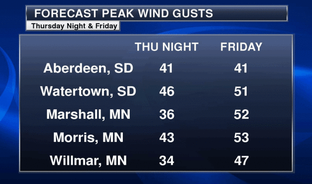
November 18, 1994: 58 to 69 mph wind gusts result in isolated damage to structures across south central and southeastern Minnesota. Some of the counties included were Blue Earth, Faribault, Freeborn, Goodhue, Le Sueur, Nicollet, Rice, Steele, and Waseca.
November 18, 1979: A heat wave continues in Southwest Minnesota. The temperature hits 70 degrees at Browns Valley.
Slushy Possibilities – Blizzard Potential West of MSP
Maybe if I put the parka on over my shorts I’ll be OK? Wednesday’s 60-degree warmth seems like a meteorological mirage. Blame a low sun angle. The northern hemisphere has caught a cold – the first real sneeze of Canadian air spinning up an intense storm today.
A tight pressure gradient causes air to accelerate into a partial vacuum (the center of low pressure) at speeds as high as 50-55 mph over western Minnesota, creating white-out conditions. I’d think twice about driving toward the Dakotas, unless you’re a fan of white-knuckle driving.
The axis of heaviest snow, 8-12 inches or more, runs from Windom to Wadena to Walker – into the Minnesota Arrowhead. ECMWF guidance prints out 5-10″ inches or so for St. Cloud, Brainerd and Duluth; maybe a sloppy inch or two for the Twin Cities, where snow will melt on contact until late afternoon today. Consider this payback for the warmest start to November on record, statewide.
Skies clear over the weekend with a little rain next Tuesday, but dry weather on Thanksgiving with highs in the low 40s.
That’s “average” for late November, remember?
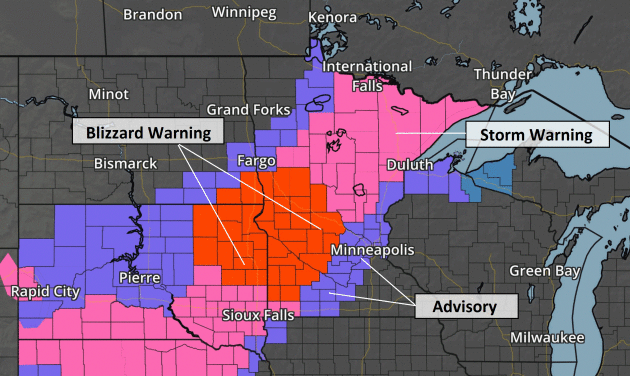
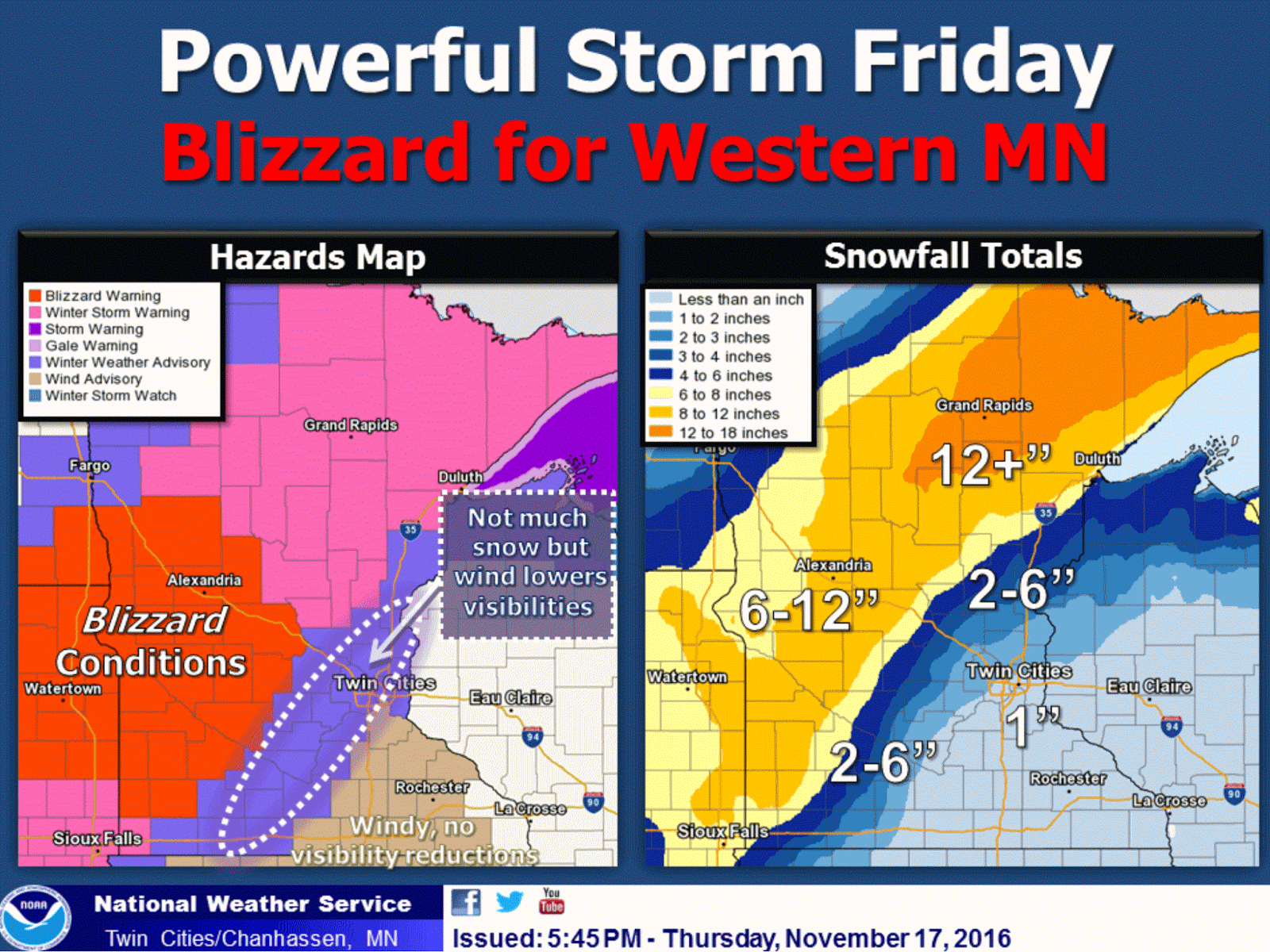
Blizzard Warning. The National Weather Service has expanded the area under a Blizzard Warning to Willmar and St. Cloud. An hour or two west of the Twin Cities and travel conditions will range from treacherous to impassable. Details:
A BLIZZARD WARNING IS IN EFFECT FRIDAY FOR MUCH OF WEST CENTRAL MINNESOTA...MAINLY WEST OF REDWOOD FALLS TO WILLMAR AND ALEXANDRIA. THIS AREA WILL SEE THE DEVELOPMENT OF BLIZZARD CONDITIONS FRIDAY MORNING AS NORTHWEST WINDS OF 30 TO 40 MPH WITH GUSTS T0 50 MPH COMBINE WITH HEAVY SNOW. THIS WILL CAUSE CONSIDERABLE BLOWING SNOW AND WHITEOUT CONDITIONS WITH TRAVEL
BECOMING VERY DIFFICULT OR IMPOSSIBLE ACROSS WEST CENTRAL MINNESOTA.

TO THE EAST OF THE BLIZZARD AREA...WINTER STORM WARNINGS AND ADVISORIES ARE IN EFFECT WHERE WINDS ARE NOT EXPECTED TO BE QUITE AS STRONG AND SNOW AMOUNTS WILL BE LESSER. THE WINTER STORM WARNING INCLUDES AREAS NEAR ST CLOUD...LITTLE FALLS...AND LONG PRAIRIE. THE WINTER WEATHER ADVISORY IS IN EFFECT FOR MUCH OF
SOUTH CENTRAL AND EAST CENTRAL MINNESOTA...INCLUDING THE MAJORITY OF THE TWIN CITIES METRO AREA AND MANKATO.

RAIN WILL CHANGE TO SNOW ACROSS WESTERN MINNESOTA BY EARLY FRIDAY MORNING AND BECOME HEAVY AT TIMES INTO EARLY AFTERNOON BEFORE TAPERING OFF BY EVENING. ACROSS CENTRAL AND EASTERN MINNESOTA RAIN WILL CHANGE TO SNOW FRIDAY AFTERNOON. SNOW ACCUMULATIONS OF 6 TO 12 INCHES ARE EXPECTED WEST OF A LINE FROM REDWOOD FALLS TO ST CLOUD AND LAKE MILLE LACS WITH THE HEAVIEST AMOUNTS OVER DOUGLAS...TODD...AND MORRISON CONTINUES. AMOUNTS WILL TAPER OFF
QUICKLY TO THE EAST...WITH AROUND ONE INCH EXPECTED IN EASTERN PARTS OF THE ADVISORY AREA INCLUDING THE TWIN CITIES METRO.
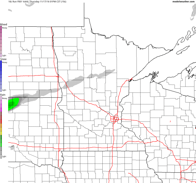
Future Radar. 4km NAM (WRF) guidance from NOAA shows a band of heavy, wind-whipped snow setting up over western and central Minnesota this morning, but rain may not change over to snow in the Twin Cities until later this afternoon, with a fair amount of melting on contact, which will help to keep amounts down in the immediate metro, where snow totals should range from a coating to an inch or two. Source: NOAA and AerisWeather.
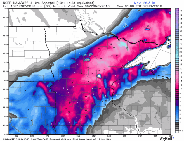
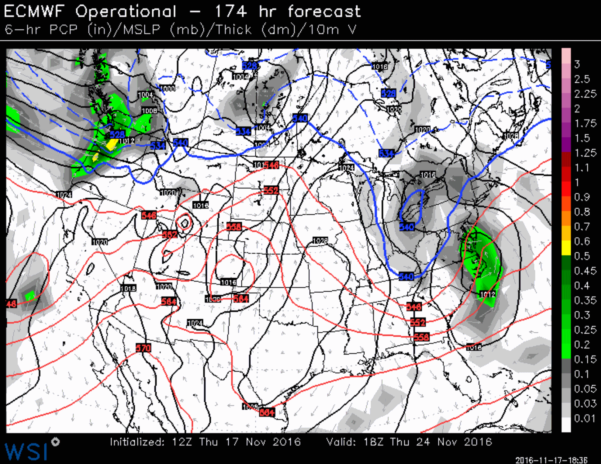
Big Snow Maker for Central Minnesota? Latest models push the axis of heaviest snow a bit farther east; NAM guidance hinting at a foot for the Brainerd Lakes – maybe a half foot or more for St. Cloud. Source: WeatherBell.
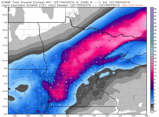
ECMWF Snowfall Prediction. Although not quite as impressive as the 4km NAM the European model prints o ut 10-12″ from near Windom to Alexandria to Wadena and Walker into much of the Minnesota Arrowhead.
BPI: Blizzard Potential Index. Our internal models show a high probability of blizzard conditions (35 mph sustained winds with visibility under 1/4 mile) from near Sioux Falls to Granite Falls and Alexandria this morning. Source: AerisWeather.

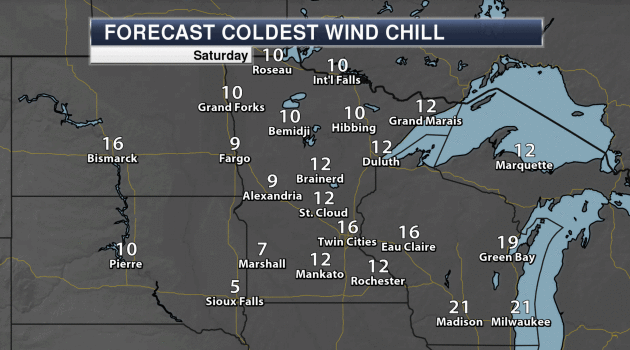
Winter’s First Smack. And to think it was 61F in the Twin Cities on Wednesday. By Saturday morning wind chills dip into single digits over far western Minnesota (with fresh snow on the ground). 16F at Minneapolis St. Paul should get your attention. Source: AerisWeather AMP.
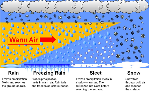
How To Survive a Winter Storm. Meteorologist Susie Martin at AerisWeather has a review and some good advice as we sail into primetime for wintry precipitation: “…Winter storms can bring a variety of precipitation. For example, a storm may begin to produce rain, but as cold air arrives, that precipitation can change over into freezing rain or snow. It all depends on the depth of the layer of warm air (above 32°F) present. As shown in the chart above, clouds may begin precipitating snow, but as the snow encounters the warmer layer of air, it melts. The degree of melting can mean the difference between snow, ice or sleet. The deeper the layer of warm air, the more liquid the precipitation will become. Freezing rain is, personally, my least favorite. This requires a rather deep layer of warm air above the ground and freezing or subfreezing conditions at the surface. In this scenario, the precipitation freezes on contact with the ground. This can be very dangerous as it’s easy to think it’s simply raining outside, but then you step outside to slip and fall on the slick sidewalk as a thin layer of ice has formed…”
Thanksgiving Day: GFS. NOAA’s GFS model is predicting a cold rain for much of New England next Thursday with snow showers for upstate New York and the mountains of northwest Colorado. The next Pacific storm pushes rain into the Portland and Seattle; otherwise the rest of America looks dry and relatively mild for late November. Source: WSI.
Thanksgiving Day: ECMWF. The European model suggests light showers of rain and wet snow for New England; heavier rain over the eastern Carolinas and Mid Atlantic as well as the Pacific Northwest. Dry weather prevails across most of America with unusually mild weather from the Plains into the southwestern USA. Source: WSI.
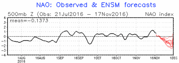
Record Warmth in November – But Big Changes Coming? Jason Samenow tracks the bubble of unusual warmth over North America, and a potential shift in the pattern brewing for December. We’re due. Here’s an excerpt at Capital Weather Gang: “…Beyond Thanksgiving into early December, some forecasters are intrigued by the GFS model, which is advertising a radical change in the weather pattern over North America. It suggests a major destabilization of the polar vortex and for the North Atlantic Oscillation to plunge into the negative territory. When this oscillation is strongly negative, it promotes the flow of Arctic air into the eastern United States, and the pattern is often favorable for snowstorms. “Time to gas up the snow blower across the U.S.,” tweeted Judah Cohen, a seasonal forecaster for Atmospheric and Environmental Research. “IF (big if) pattern verifies, that is as favorable a pattern for snowstorms that I can recall…”
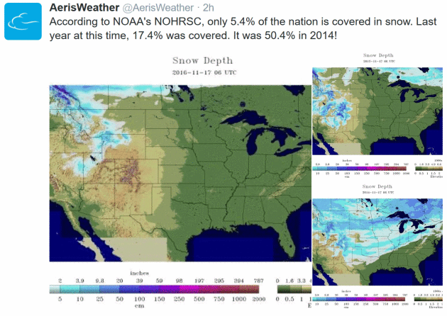
NOAA: U.S. Snowcover Hits an “All-Time Low” for November. Here’s the intro to an explainer at Engadget: “Researchers just supplied more evidence that climate change-related temperature increases are having a material effect on the planet. America’s National Oceanic and Atmospheric Administration reports that snow cover in the lower 48 states is the lowest ever recorded for mid-November. As you can see in the map below, there’s very little snow on the ground in the country — you’d likely have to climb a mountain to see it. For contrast, the average snow cover between 1981 and 2010 reached as far south as New Mexico...”
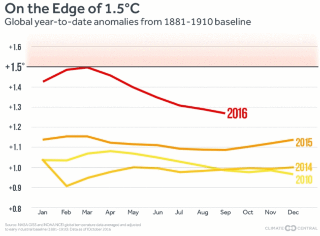
Second Warmest October Cements Hottest Year. Climate Central has an update: “…But even La Nina years now are warmer than El Niño years several decades ago because of the long-term warming caused by carbon dioxide and other heat-trapping gases emitted into the atmosphere. Because of the combination of El Niño and manmade warming, 2016 will best 2015 as the hottest year on record, the third record-warm year in a row, the World Meteorological Organization told delegates at the U.N. climate meeting in Morocco...”
Graphic credit: “The year-to-date temperature anomaly (through September) using the 1891-1910 baseline.”
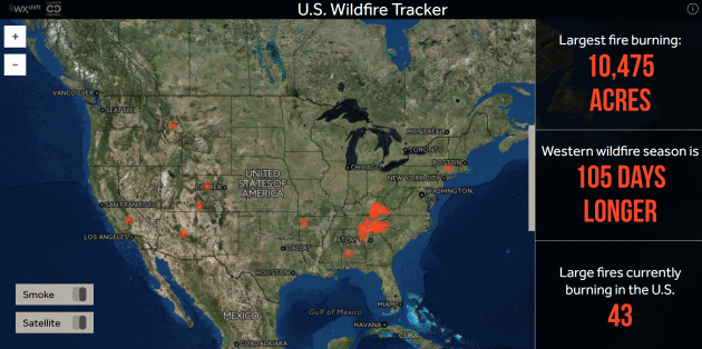
43 Large Fires Burning Across USA. Check out the latest statistics from the U.S. Wildfire Tracker, courtesy of WXshift.

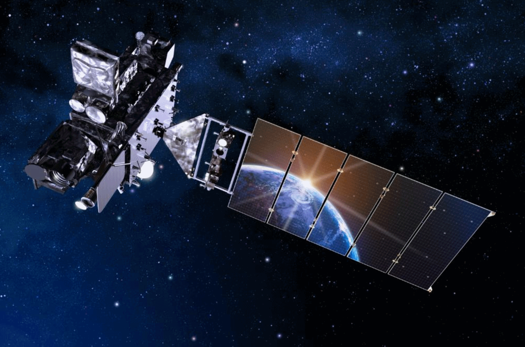
Weather Satellite Revolution. Here’s more detail from NOAA: “Included in the advanced equipment on the satellite is the new Geostationary Lightning Mapper. In addition to providing forecaster with information on the potential for severe storm development this new technology will allow NOAA to provide real-time observations of lightning data directly to the public. This will allow the public to track lightning activity throughout the country, monitor nearby storms, and curtail outdoor activities early to avoid the lightning threat.
This year there have been 36 lightning deaths in the U.S., the most since 2007 when there were 45 fatalities. On average there have been about 30 lightning deaths in the U.S. in recent years.
More information on the Geostationary Lightning Mapper can be found at:
Read more at: http://phys.org/news/2016-11-noaa-goes-r-satellite.html#jCp
Read more at: http://phys.org/news/2016-11-noaa-goes-r-satellite.html#jCp


How Wind and Solar Plan To Thrive During the Trump Presidency. Here’s an excerpt from a story at Utility Dive: “…Our industry will be fine,” Sunnova CEO John Berger told Utility Dive. Sunnova is one of the leading national rooftop solar providers. “Business models will change and the companies that can’t deliver a better service at a better price won’t make it.” Losing its 30% federal investment tax credit (ITC) might even provoke constructive change, Berger said. “But with or without the ITC, this industry will thrive and that is because we are quickly driving down the cost of solar and solar components and now the cost of batteries is coming down as fast...” Image credit: NAHB livestream

Protecting Your Digital Life in 7 Easy Steps. The New York Times has some good advice: “There are more reasons than ever to understand how to protect your personal information. Major hacks seem ever more frequent. Investigators believe that a set of top-secret National Security Agency hacking tools were offered to online bidders this summer. And many of those worried about expanded government surveillance by the N.S.A. and other agencies have taken steps to secure their communication…”
Image credit: Kacper Pempel/Reuters.

These 6 New Technology Rules Will Govern Our Future. Here’s a clip from a story at The Washington Post that got my full attention: “…In every field, machines and robots are beginning to do the work of humans. We saw this first happen in the Industrial Revolution, when manual production moved into factories and many millions lost their livelihoods. New jobs were created, but it was a terrifying time, and there was a significant societal dislocation (from which the Luddite movement emerged). The movement to digitize jobs is well underway in low-salary service industries. Amazon relies on robots to do a significant chunk of its warehouse work. Safeway and Home Depot are rapidly increasing their use of self-service checkouts. Soon, self-driving cars will eliminate millions of driving jobs. We are also seeing law jobs disappear as computer programs specializing in discovery eliminate the needs for legions of associates to sift through paper and digital documents…”

SUNDAY: Cold start, plenty of sunshine. Winds: SE 8-13. Wake-up: 21. High: 38
MONDAY: Partly sunny, average temps. Winds: SE 10-15. Wake-up: 24. High: 42
TUESDAY: A little light rain, wet roads. Winds: SE 10-15. Wake-up: 32. High: 43
WEDNESDAY: Light mix tapers, slow PM clearing. Wake-up: 36. High: 42
THURSDAY: Sunny peeks, dry on Thanksgiving Day. Wake-up: 29. High: 41
Climate Stories

Trump Win Opens Way for China To Take Climate Leadership Role. Reuters reports: “The election of climate change skeptic Donald Trump as president is likely to end the U.S. leadership role in the international fight against global warming and may lead to the emergence of a new and unlikely champion: China. China worked closely with the administration of outgoing President Barack Obama to build momentum ahead of the 2015 Paris Agreement on climate change. The partnership of the two biggest greenhouse gas emitters helped get nearly 200 countries to support the pact at the historic meet in France’s capital...”
Photo credit: “U.S. President-elect Donald Trump gestures as he speaks at election night rally in Manhattan, New York, U.S., November 9, 2016.” REUTERS/Mike Segar.
Climate Change, Hurricanes and Floods: An LSU Dialogue. Louisiana will be one of the first states to be impacted by rising seas and heavier summer rains; here’s an excerpt from NOLA.com: “Climate change, hurricanes and floods were hot topics Wednesday (Nov. 16) during the Louisiana State University International Programs’ intercultural dialogue on weather, water and climate. Whatever the extent of climate change, one speaker said, Louisiana will be in the crosshairs. Jay Grymes, chief meteorologist at WAFB television, opened the presentations with a focus on the state’s wet climate and the potential effects of climate change. He warned that of the lower 48 states, Louisiana might be the most severely affected…”
Photo credit: Max Becherer, AP.
Tracking Effects of Climate Change on Human Health. Here’s an excerpt from Huffington Post: “…It is vital that progress on limiting emissions of carbon dioxide and short-lived climate pollutants, such as methane and black carbon, is monitored. Governments must be held accountable for meeting their nationally determined contributions towards global cuts in emissions, and incentivised to go further. Climate change poses major threats to human health but policies to reduce emissions have great potential to improve health in the near-term, including by reducing air pollution and encouraging dietary changes. A new international initiative aims to provide more crucial information on the relationship between climate change and health…”
Sticking To Lower 1.5C Warming Limit Would Protect World Economy. Here’s a clip from Reuters: “Limiting global temperature rise to 1.5 degrees Celsius, a goal of the Paris Agreement on climate change, would avoid economic losses by 2050 of $12 trillion, or around 10 percent of the world’s GDP, compared to staying on the current track of at least 3 degrees of warming, the U.N. Development Programme said on Wednesday. Sticking to the 1.5 degree limit is feasible, it said in a report for the Climate Vulnerable Forum, a group of more than 40 countries most at risk from climate change...” (Image credit: NASA).
WMO: Past 5 Years Hottest on Record, Worldwide. Here’s an excerpt from a story at Fusion: “…On November 8, the World Meteorological Organization (WMO) delivered a report at the international conference on climate change in Morocco (COP22) which was called in order to carry forward the Paris agreement of COP21. The WMO reported that the past five years were the hottest on record. It reported rising sea levels, soon to increase as a result of the unexpectedly rapid melting of polar ice, most ominously the huge Antarctic glaciers. Already, Arctic sea ice over the past five years is 28% below the average of the previous 29 years, not only raising sea levels, but also reducing the cooling effect of polar ice reflection of solar rays, thereby accelerating the grim effects of global warming…” (Image: NASA).

Military Leaders Urge Trump To See Climate As a Security Threat. Scientific American has the story; here’s an excerpt: “…The Center for Climate & Security in its briefing book argues that climate change presents a risk to U.S. national security and international security, and that the United States should advance a comprehensive policy for addressing the risk. The recommendations, released earlier this year, were developed by the Climate and Security Advisory Group, a voluntary, nonpartisan group of 43 U.S.-based senior military, national security, homeland security and intelligence experts, including the former commanders of the U.S. Pacific and Central commands. The briefing book argues that climate change presents a significant and direct risk to U.S. military readiness, operations and strategy, and military leaders say it should transcend politics. It goes beyond protecting military bases from sea-level rise, the military advisers say. They urge Trump to order the Pentagon to game out catastrophic climate scenarios, track trends in climate impacts and collaborate with civilian communities...” (File photo: AP).
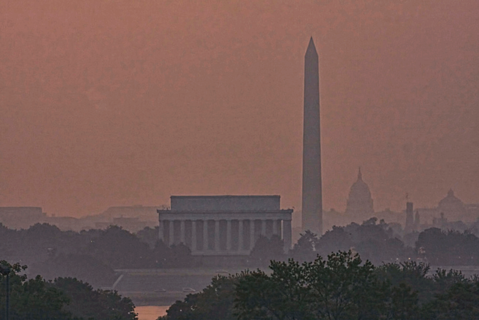
DC Prepares For Heat Emergencies To Nearly Double by 2020, Among Other Climate Change Effects. Here’s a clip from DCist: “…D.C. currently experiences around 11 heat emergency days per year, which could almost double to 20 days by 2020 and spike up to 75 days by 2080, according to the report. Washingtonians should also expect much warmer average temperatures; longer, hotter, and more frequent heat waves; and more frequent and intense heavy rain and flooding. The city has already begun to see record-breaking heat waves and snowstorms as well as flooding caused by rising sea levels and high rainfall. Climate Ready DC, the city’s readiness plan, looks at current weather patterns and predicts how they will change by 2080. The report, which was developed by consulting with experts inside and outside of District government, then outlines the city’s strategies to adapt...” Photo credit: SweetJen34
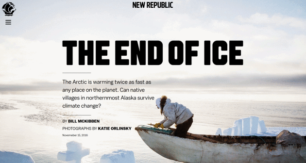
The End of Ice. Check out the photo essay at New Republic: “…The peculiar physics of climate change have played a particularly nasty trick on those who live farthest to the north. The steady, relentless stream of data from satellites, weather buoys, and remote weather stations makes it clear that the Arctic—which has supported human life for millennia—is warming twice as fast as any place on the planet. But you don’t need data to understand what’s happening: Pictures will do...”
