50s and 60s In December? It Has Happened!
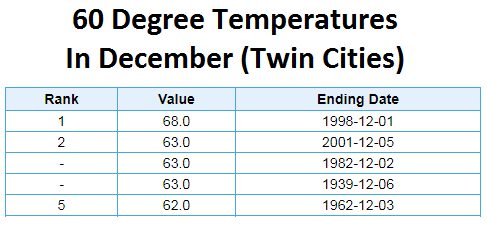
Friday is the start of meteorological winter (running until the end of February), which typically marks the coldest three months of the year. However, instead of thinking about the cold because, lets face it Mother Nature isn’t either (at least through the weekend), I’ll take a look at the warmest December days on record. The Twin Cities have hit 60 five times during the month of December across the entire record going back to 1872. The overall warmest day occurred on December 1st, 1998, when we hit a high of 68. In fact, the first five days of December 1998 saw highs of 50 or above.
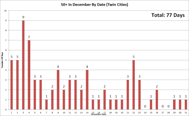
Expanding the temperature range, the Twin Cities has hit 50 or higher 77 times in the Twin Cities record, doing it at least once every day during the month except three days (the 24th, 27th and 28th). The date we’ve hit 50+ the most during December is on the 3rd, when we’ve hit it nine times – and it could become ten this Sunday. The last time we hit 50+ in December was December 15, 2014 when the high reached 51. More on the warmth – and when it ends – below.
_______________________________________________
_______________________________________________
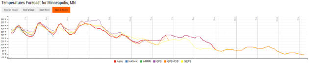
Extended Twin Cities Forecast
_______________________________________________
This Day in Weather History
December 1st
1998: The warmest December day ever in the Twin Cities is recorded, with a high of 68 degrees. St. Cloud rose to 61.
1985: Parts of central Minnesota receive up to a foot of snow. Snowfall totals include 12 inches at Waseca and Milaca, 11.3 at Alexandria, and 11 inches at Fairmont and Long Prairie.
_______________________________________________
Average Temperatures & Precipitation for Minneapolis
December 1st
Average High: 32F (Record: 68F set in 1998)
Average Low: 18F (Record: -15F set in 1893)
Average Precipitation: 0.04″ (Record: 0.83″ set in 1985)
Average Snow: 0.4″ (Record: 8.4″ set in 1985)
________________________________________________
Sunrise/Sunset Times for Minneapolis
December 1st
Sunrise: 7:31 AM
Sunset: 4:32 PM
*Length Of Day: 9 hours, 1 minute and 39 seconds
*Daylight Lost Since Yesterday: ~1 minute and 31 seconds
*Latest Sunrise: December 30th-January 5th (7:51 AM)
*Earliest Sunset: December 5th-13th (4:31 PM)
________________________________________________
Minnesota Weather Outlook
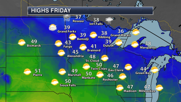
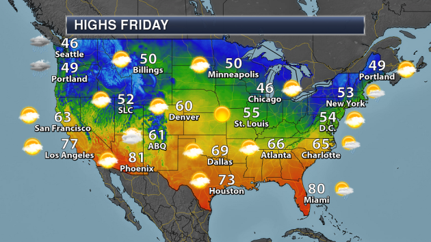
It’ll be a nice start to December and meteorological winter across most of the state Friday, with highs in parts of southern Minnesota reaching the 50s. In the entire meteorological record for the Twin Cities (going back to 1872), we have only have had a high of 50 or above 77 times. Can we make it 78 Friday? We shall see. Temperatures will be in the 30s across northern Minnesota, and we will be watching the chance of some snow showers at times due to a mid-level system passing through.
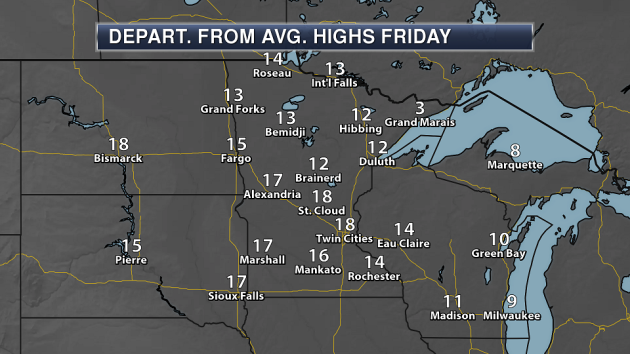
We’ll definitely see a warm start to December Friday, with highs across most of the state (sorry, Grand Marais) starting the month off a good 10-20 degrees above average.
Make sure you enjoy the warmth expected Friday and into the weekend, as a change is certainly coming in as we head into next week… and, as typical during winter, you can blame Canada. A blast of cool air will follow a cold front as it moves through the state Sunday Night into Monday, with falling temperatures expected throughout the first day of the work week next week. A secondary cold front Tuesday will help push highs only into the 20s by next Wednesday. It looks like another cold blast of air will move in next weekend into the second full week of December, bringing another blast of cold air with it.
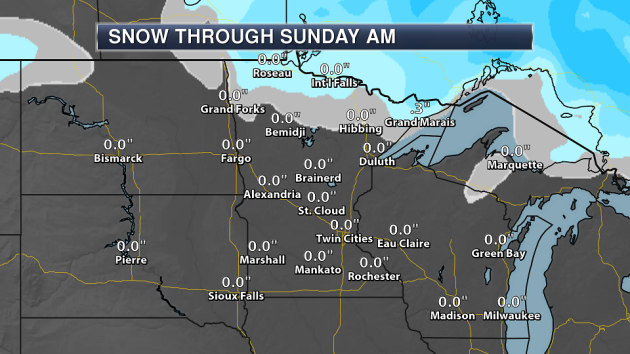
A chance of some light rain/snow will exist across the Arrowhead Friday Night as a mid-level system passes through. Any accumulation is expected to be light, with maybe up to three tenths of an inch in the Grand Marais area.
________________________________________________
National Weather Stories
Another frontal system will approach the Pacific Northwest Friday, bringing another round of rain and snow to the region. Meanwhile, the front that moved onshore Thursday will continue east, reaching parts of the upper Midwest by the evening. However, only some light rain or snow is expected across northern Minnesota and Wisconsin as well as the U.P. of Michigan during the evening and Friday Night, otherwise that front will pass through the middle of the country dry. A few showers will be possible across southern Georgia and northern Florida as a front stalls out in the region.
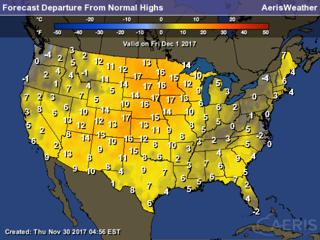
Most of the lower 48 will see temperatures that are above average for this time of year, with the highest above average numbers expected across the central United States into the Four Corners region.
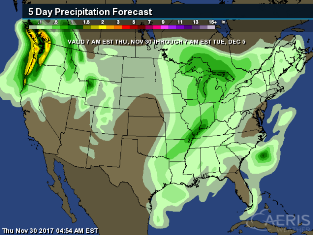
The heaviest precipitation though Tuesday morning is expected in the Pacific Northwest, where 2″+ of liquid precipitation could fall. Most other locations will see light precipitation – if any at all.
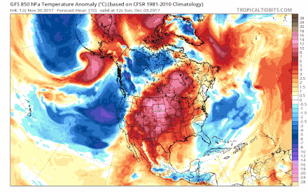
Enjoy the warmth while it lasts, as a major change in the forecast is coming into next week for the eastern half of the United States. A blast of cold air will sink south out of Canada, plunging temperatures across the nation by the middle and end of the week. Additional cold air blasts are expected to move south of the border as we head toward next weekend and into the middle of the month.
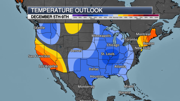
We can see that blast of cold air reflected in the 6-10 day temperature outlook from the Climate Prediction Center across parts of the central and eastern United States, with the odds showing the potential of below average temperatures. If you want above average warmth during this period, the odds are higher if you head out to California or across New England.
________________________________________________
A Hurricane Season Bright Spot: The Forecasts
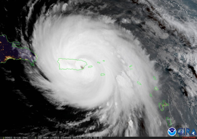
If there is one bright spot from this hurricane season, it is that track forecasts are being more accurate. Intensity forecasts, on the other hand, aren’t. More from the Miami Herald: “But for hurricane researchers, the season that ends Nov. 30 will also be remembered as a grueling run for prediction models and emerging forecast tools like Kirtman’s that up to now had not seen such monster storms. So how did they perform? The good news is the chief model produced by the National Oceanic and Atmospheric Administration and used by the National Hurricane Center helped produce the best track forecasts since the center began issuing tracks. Earlier warnings came for storms nearing land, and new maps provided the arrival times for damaging winds.” (Image: GOES-16 geocolor image of Hurricane Maria over Puerto Rico as it made landfall on September 20, 2017. Credits: NOAA/NASA/CIRA)
Trump’s NOAA Pick Believes In Man-Made Climate Change
President Trump’s nominee to run NOAA, AccuWeather’s CEO Barry Myers, stated in a confimation hearing Wednesday that he does believe in recent findings connecting climate change and human activity. More from Mashable: “Perhaps the White House wasn’t paying close attention when they picked Barry Myers to run the National Oceanic and Atmospheric Administration (NOAA). During Myers’ confirmation hearing on Wednesday, he repeatedly expressed support for climate science research, and admitted that a recent federal assessment clearly indicated that the vast majority of global warming is due to human activities. This puts Myers, the former CEO of AccuWeather, out of step with other high-profile President Donald Trump nominees, including Jim Bridenstine, Trump’s pick to lead NASA.”
Wind Power Now The Second Largest Electricity Source In Texas
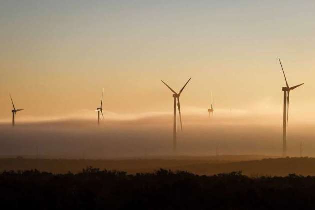
While natural gas is still the largest electricity source in Texas, coal just got kicked out of the second spot and was replaced with wind power. More from the Houston Chronicle: “Wind power, by one important measure, surpassed coal last week to become the second-largest electricity source in Texas, yet another milestone in the state’s march toward greater reliance on renewable energy. When a 155-megawatt wind farm in West Texas began commercial operation this month, it pushed the state’s wind power capacity to more than 20,000 megawatts, surpassing 19,800 megawatts of capacity from coal-fired power plants, according to the Electric Reliability Council of Texas, which oversees 90 percent of the state’s grid. One megawatt is enough to power 200 homes on a hot Texas day.” (Image: A thick cloud of fog and morning light engulfs several 285ft tall 2.5 MW Clipper wind turbines at the BP Sherbino Mesa II Wind Farm, Monday, Feb. 20, 2012, in Fort Stockton. After cutting its solar program last year, BP is beefing up its investments into wind energy and recently launched its fourth Texas wind farm, in Fort Stockton. On 20,000 acres in Pecos County, the Sherbino II farm has 60 wind turbines to generate enough electricity to power more than 175,000 homes. ( Michael Paulsen / Houston Chronicle ))
________________________________________________
Thanks for checking in and have a great Friday! Don’t forget to follow me on Twitter (@dkayserwx) and like me on Facebook (Meteorologist D.J. Kayser)!
– D.J. Kayser

