45 F. high in the Twin Cities Monday.
24 F. average high on January 26.
18 F. high on January 26, 2014.
1″ snow on the ground at MSP International Airport.
January 26, 2006: A record high temperature of 50 degrees is set at the Eau Claire Regional Airport.
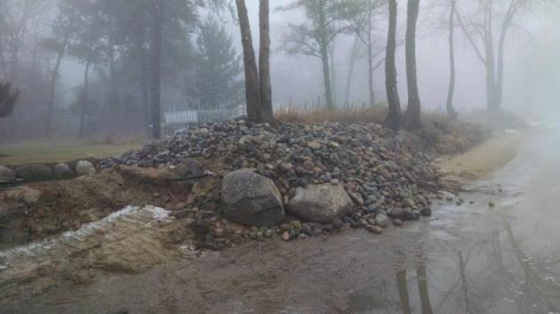
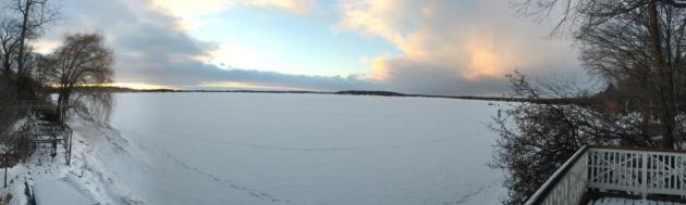
Creeping Shorelines
A baffling, super-sized January Thaw is doing more than frustrating snow lovers. Huge swings in temperature either side of 32F are creating tremor-size cracks in parking lots. The premature freeze-thaw cycle is rearranging shorelines on lakes up north.
A friend, Jim Tucker, lives in Pequot Lakes. He showed me massive berms of sand and rock pushed toward shore. Every new dip below freezing causes expansion of water, sand & mud, creating new lakeshore headaches. One of Jim’s photos is above – he hasn’t seen anything like this in January before.
The freeze-thaw cycle comes in March, not January, but someone forgot to tell Old Man Winter.
Talk about a disconnect: an historic blizzard has shut down much of the Northeast; it’s the rough equivalent of a tropical storm, but with snow and subzero wind chills. While I receive increasingly frantic notes from snow fans. For the record: I haven’t given up on snow, but El Nino will continue to divert MOST sloppy storms well south and east of Minnesota. 40s into Wednesday, then a chance of light snow Saturday. We catch a cold early next week (2 days of wind chill) but models show a predominately Pacific flow, with one mild front after another, into much of February.
Feels a little like 2012.
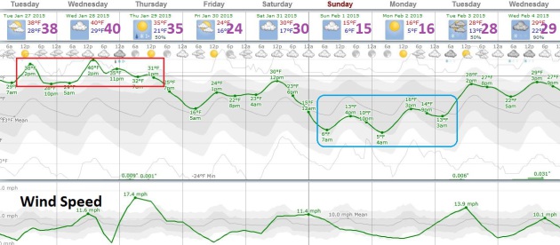
Shrinking Early February Cold Wave. Temperatures continue to trend well above average into Saturday before cooling down, although it doesn’t look nearly as arctic as it did just a few days ago, maybe 2-3 days in the teens? Shocking news: no significant snowfalls are in sight, thanks to a predominately mild and dry west/northwest wind flow aloft from the Pacific. Gulf moisture can’t flood northward, limiting how much snow can fall.
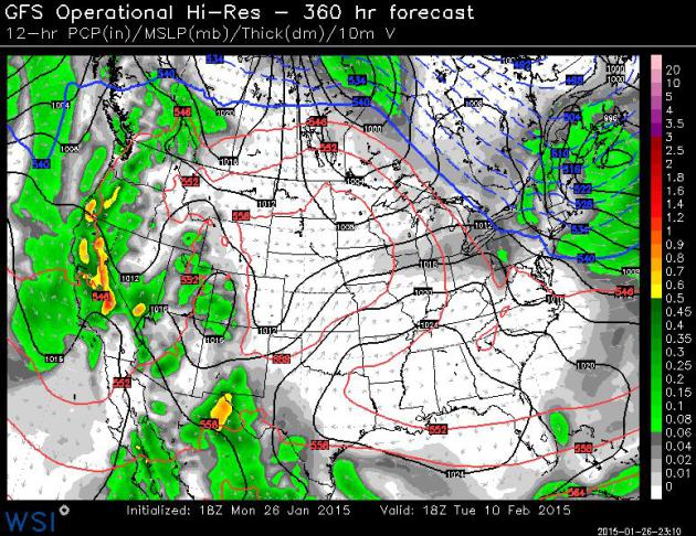
An Early March? GFS guidance, valid Tuesday, February 10, shows a massive ridge of warm high pressure from the Rockies into the Great Lakes, which may translate into 40s, even a few 50s close to home. Another wet cycle for California helps to put another small dent in a long-term drought. With the exception of northern New England most of the USA is abnormally mild. Map: WSI Corporation.

Alerts Broadcaster Briefing: Issued Monday morning, January 26, 2015.
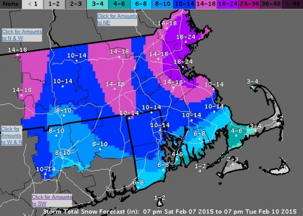
* What may become a Top 10 Snowstorm from New York City to Boston continues to intensify; blizzard conditions likely from this evening into Tuesday, extending into Wednesday morning in the Boston area.
* 1 to 3 foot snowfall amounts still likely from New York City and Long Island to Hartford, Providence, Boston and Portland. By Tuesday night and Wednesday there may be reports of 4-6 foot drifts as virtually all traffic, land and air, grinds to a halt for the better part of 48 hours.
* With winds gusting over 50 mph into Tuesday the risk of power outages will be high. Resources to track power outages, state by state, below.
* Significant risk of coastal flooding and beach erosion, especially at high tide over the next 24 hours.
Hype-Worthy Storm. A fresh injection of upper level energy, coupled with unusually warm Gulf Stream water off the East Coast, is setting the stage for a potentially historic blizzard for coastal New England. The storm stalls, temporarily, prolonging a fire hose of Atlantic moisture from Long Island to Cape Cod and Boston, resulting in some extreme snowfall totals. Throw in wind gusts of 40-50 mph. tonight and Tuesday and you have all the ingredients for a crippling snowstorm.
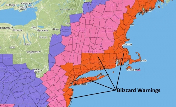
Blizzard Warnings In Effect. A Blizzard Warning means that treacherous/impassable travel conditions are imminent. Warnings are posted from Atlantic City and New York To Hartford, Providence and Boston for white-out conditions tonight into early Wednesday. Map: Aeris Weather.
Models are in fairly good agreement:
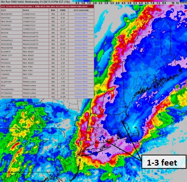
A Convergence of Factors. Latest guidance prints out 2.6″ liquid for New York City. Since this will fall as all snow that translates into at least 2 feet of snow, possibly 3 feet since temperatures will fall into the teens tomorrow, making this a light, fluffy, powdery snow, prone to blowing and drifting. Map: Aeris Weather.
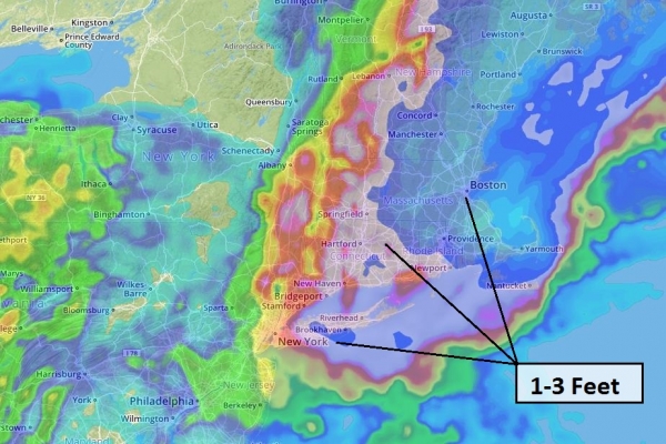
Another Solution – Just As Extreme. All the models we study before making a forecast are in fairly good agreement. The only question: will it wind up being a foot, or closer to 2-3 feet by Tuesday night and Wednesday morning? On our scale from nuisance to plowable and crippling there’s little doubt this will be a crippling storm, probably the most snow in New York City since 20″ fell in 2010.
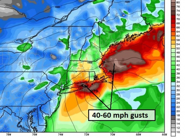
Why We’re Still Concerned About Power Outages. Model output above from WeatherBell show winds at 10-meters above the ground gusting to near hurricane force on Tuesday. Although surface gusts won’t be quite that high I could easily see 40-60 mph wind gusts, capable of bringing down trees and power lines. Extended power outages can’t be ruled out, especially near the coast. Here are additional resources to track potential power failuress on the grid:
New York —
- Consolidated Edison Company of New York (Con Edison) – http://apps.coned.com/stormcenter_external/default.html
- PSEG Long Island – https://www.psegliny.com/c.cfm/Outage
- National Grid – https://www1.nationalgridus.com/PowerOutageMap-MA-RES?ng=us
- New York State Electric & Gas (NYSEG) – http://outagemap.nyseg.com/ny/?style=newyork
New Jersey —
- Atlantic City Electric – http://www.atlanticcityelectric.com/pages/connectwithus/outages/outagemaps.aspx
- Public Service Electric and Gas Company (PSE&G) – http://outagecenter.pseg.com/external/default.html
- Jersey Central Power and Light Company – http://outages.firstenergycorp.com/nj.html
Connecticut —
- Connecticut Light & Power – http://www.cl-p.com/outage/OutageMap.aspx
- United Illuminating – http://bit.ly/1ePFt5J
Delaware —
- Delmarva Power – http://www.delmarva.com/home/emergency/maps/stormcenter/
- Delaware Electric Cooperative – http://www.delaware.coop/my-services/outage-map—
Rhode Island —
- National Grid – https://www1.nationalgridus.com/PowerOutageMap-RI-RES
Massachusetts —
- NSTAR – http://outagemap.nstar.com/outage/OutageMap.aspx
- Western Massachusetts Electric – http://www.wmeco.com/outage/outagemap.aspx
- National Grid – https://www1.nationalgridus.com/PowerOutageMap-MA-RES?ng=us
New Hampshire —
- Public Service of NH – http://www.psnh.com/outage/outagemap.aspx
- National Grid (including Granite State Electric) – https://www1.nationalgridus.com/PowerOutageMap-MA-RES?ng=us
Maine —
- Central Maine Power – http://www.cmpco.com/outages/outageinformation.html
- Emera Maine – http://apps.emeramaine.com/about/outages/Outage_Map.cfm
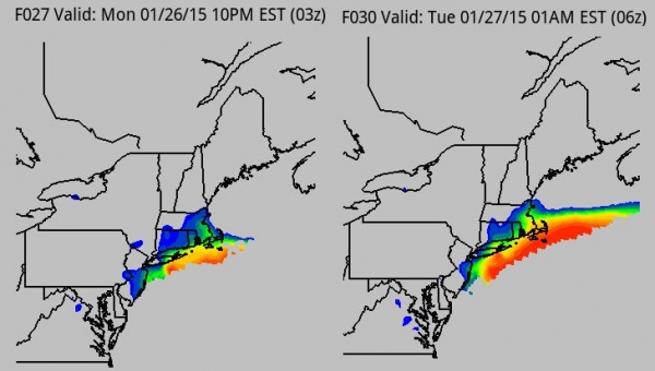
Timing The Blizzard. Blizzard conditions (sustained winds over 35 mph with visibility under 1/4 mile) reach Long Island and Martha’s Vineyard this evening, expanding into metro New York City and Boston during the wee hours of the morning Tuesday. Source: Aeris Weather.
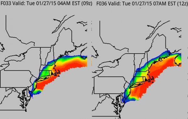
Blizzard Increases In Coverage Tuesday. By 7 am Tuesday blizzard conditions are likely from Atlantic City to New York, Long Island, Providence and Boston.
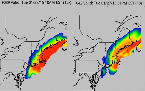
Blizzard Shifts to Boston Late Tuesday and Tuesday night. By tomorrow afternoon the heaviest snows will being to push out of metro New York City into Providence and Boston. I expect blizzard conditions to spill over into much of Wednesday in the Boston and Portland area.
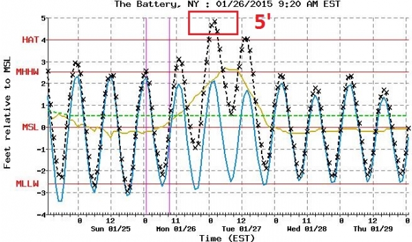
Another Factor To Consider: Coastal Flooding. Models show a 5 foot storm surge at The Battery, in Lower Manhattan, shortly after midnight tonight. High waves will be superimposed on top of this surge, resulting in moderate to major lowland flooding in the Tri-State area. This will be comparable to a moderate tropical storm impacting the region. Source: NOAA.
Boston Surge: 8 Feet. An even more extreme storm surge is forecast for Boston Harbor, 8 feet above mean sea level by 5 am Tuesday, which whould be the most extreme high tide. Additional flooding is possible around 5 pm tomorrow.
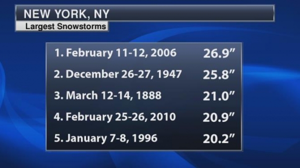
Top 10 Snowfall for New York City. If the forecasts verify this could easily wind up being a Top 5 snowfall for New York, certainly the biggest since 20.9″ fell in February of 2010.
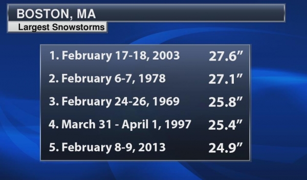
Boston Records. This should wind up being a Top 5 or Top 10 snowfall for Boston, the most snow since 2 feet feel in February 2013.
Summary: The media coverage is probably warranted this time around. The most significant blizzard to strike New York City and Boston in at least a decade is winding up. What makes this storm especially dangerous and impactful is a combination of factors:
* 1-3 feet of snow NYC to BOS, but cold surface temperatures will mean a dry, powdery snow, prone to blowing and drifting. Some spots will wind up with 4-6 foot drifts, meaning impacts much of this week. Things may not get back to normal (whatever that is) by the end of the week.
* High winds, gusting over 50 mph tonight into Tuesday, increasing the risk of power outages. I could see emergency warming centeres, even some evacuations of people from their homes, late tonight into early Wednesday.
* Coastal flooding. High tide will bring lowland and coastal flooding from midnight tonight into the afternoon hours tomorrow.
* Bitter temperatures. Readings falling into the teens tomorrow with a subzero windchill will increase the risk of frostbite and hypothermia, for people caught outdoors, and people indoors lacking electricity.
We’ll have another update Tuesday morning. Good luck, hunker down, and don’t push the weather!
Paul Douglas – Senior Meteorologist – Alerts Broadcaster

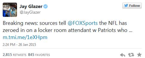
Patriots Say Study Proves Ball Deflation “Not Human Caused”. Where have you heard this before? Here’s the intro to a tongue-in-cheek look from Daily Kos: “The New England Patriots pointed to a study released today which they say shows that the alleged deflation of footballs in recent games was not due to human causes. “It’s just natural variation,” explains the executive summary of the study. “Footballs have had different inflation pressures for thousands of years.” The study was released today by the Edelman research firm, which usually focuses on swatting away the damaging efforts of environmentalists to impede progress…”
TODAY: Peeks of mild sun. Too easy. Winds: South 5. High: near 40
TUESDAY NIGHT: Partly cloudy, relatively mild. Low: 28
WEDNESDAY: What January? Thaw lingers with some sun. High: 42
THURSDAY: Flurries, cooler breeze late. Wake-up: 30. High: 35
FRIDAY: Cool sunshine, closer to average for late January. Wake-up: 20. High: 27
SATURDAY: Slight chance of light snow. Wake-up: 21. High: near 30
SUNDAY: Sunny intervals, turning colder. Wake-up: 8. High: 15
MONDAY: Sunny, cold Groundhog Day. Wake-up: 6. High: 16
Climate Stories…
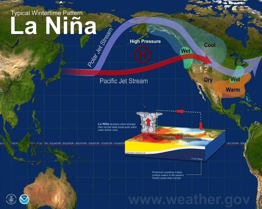
Climate Change Expected To Bring More Extreme La Ninas. Here’s an excerpt from a story at CBS News: “…A new study concludes that extreme La Nina events like this will become twice as likely in the future due to climate change. The study in Nature Climate Change found that the La Nina extreme weather — which happens about once every 23 years — will occur every 13 years by the end of this century, based on an analysis of 21 climate models. Three-quarters of those increased La Nina events would follow extreme El Nino events “thus projecting more frequent swings between opposite extremes from year to the next...”
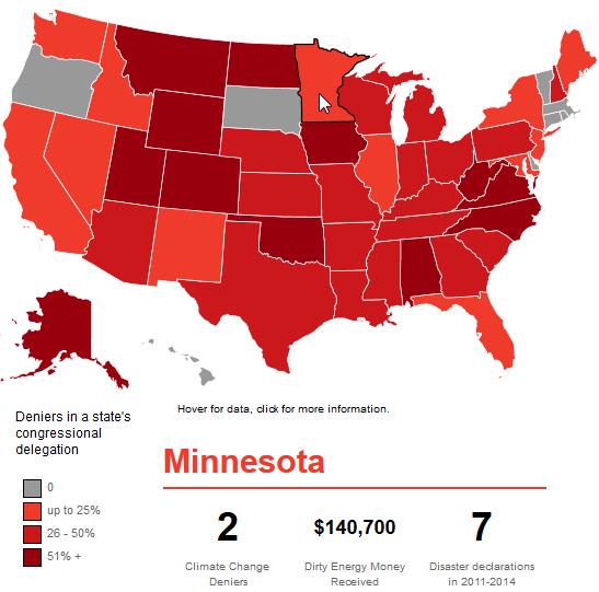
The United States of Denial. Which states send the most climate-science-deniers to Washington D.C.? Here’s an excerpt of a story and interactive graphic from onEarth: “…An analysis by the Center for American Progress, a public policy think tank, found that 53 percent of Republicans in the House and 70 percent in the Senate deny humanity’s role in climate change. (As the map shows, deniers also tend to receive a pretty penny from the fossil fuel industry.)…”

Climate-Change Consensus Is Reached Everywhere But In Washington. Here’s a snippet from an Op-Ed that resonated at The Globe and Mail: “…This is less like rearranging the deck chairs on the Titanic than looking over the railing and debating whether the giant white thing is an iceberg or a marshmallow. The consensus has been reached, gentlemen, everywhere but in Washington. Even the plutocrats at Davos are sweating through their Zegna suits: The World Economic Forum spent a day debating climate change and its disruptive effects, and listed climate-related chaos among the greatest threats facing the planet…”

After Senate Climate Votes, Dems See Rift In GOP. Will climate change become a significant issue for the 2016 presidential campaign? Can an on-the-record climate denier be nominated to represent Republicans? Here’s an excerpt from Politico: “…In the end, only a modest measure stating that climate change is real and not a hoax passed the chamber, winning even the backing Sen. Jim Inhofe, the author of a book decrying the man-made climate change. But the 15 Republicans — including seven from red states as well as one likely presidential contender, Sen. Ran Paul — went further, agreeing climate change was affected by human activity…”

Republicans Evolve on Climate Change. Here’s an excerpt of an Op-Ed at Bloomberg View: “...For years, Republicans have skirted the issue. Less noted, but equally important, is that they’re also evolving on it. Within the party, the fight has moved on from whether climate change is real to whether human activity is causing it, as the scientific evidence overwhelmingly indicates. Republicans have been reluctant to accept the evidence, because that would require doing something about it, which would lead to — and this is crux of the issue — new laws and regulations that interfere with the free market...”

What Are Republicans Going To Do About Climate Change? The Christian Science Monitor speculates; here’s a clip: “…Why does the climate vote matter? Global warming will likely be part of the conversation in the 2016 presidential race, which could include sitting Sens. Marco Rubio of Florida, Rand Paul of Kentucky, and Ted Cruz of Texas. Voters will want to know if they believe it’s an issue, and if so, how they’ll tackle it…”
Planet Keeps Getting Hotter, But Hope Could Be On Horizon. Here’s a link to an Op-Ed from minister and EEN (Evangelical Environmental Network) President Mitch Hescox. Full disclosure: I’m on their board of directors. YDr.com in York, PA has the post; here’s an excerpt: “…Using sleight-of-hand statistical mumbo-jumbo, deniers have tried to pull one over on the American people about the recent pace of global warming. Don’t be fooled. Global temperatures have continued their century’s long march upward, with 2014 being the latest exclamation point and 2015 projected to do the same. And with the heat comes extreme weather like the California drought, flooding and mudslides in Washington that killed 43, and the fact that Anchorage, Alaska was above freezing all of 2014…”
How Much Is Climate Change Going To Cost Us? Those with the least will be first to feel the impacts of climate volatility, in fact it’s already happening. Here’s a snippet of a long but excellent article looking at various scenarios from David Roberts at Grist: “…In a sense, this restates what we already know: Rich countries could do all right with slow mitigation because they are relatively robust in the face of climate impacts, but it would be devastating to poor countries. Aggressive mitigation is justified because of the threat to poor countries. (This tells you a lot about the politics of the issue.) OK, that’s what you need to know: that there is good reason, outside contested questions of “raw moralism,” to think that the models we use to assess the social cost of carbon are considerably understating it...”
