64 F. high in the Twin Cities Sunday.
72 F. average high on May 24.
80 F. high on May 24, 2015.
.29″ rain fell at KMSP yesterday. Eau Claire reported .70″ of rain.
May 24, 1925: After seeing a high of 99 degrees two days earlier, the Twin Cities picked up a tenth (.10) of an inch of snow.
May 24, 1908: Tornadoes hit the counties of Martin and Blue Earth. Source: MPX National Weather Service.

Paying Our Respects
Saturday our pontoon wouldn’t start, a stiff wind blowing us across the lake. No AAA to save us. A boater puttered over and gave us a tow – a good Samaritan, happy to help. “Lake rules” he laughed, accepting compensation in the form of cold beer.
We love the water – but we’ve had rotten luck with boats. A 33-footer sank in 2010, another pontoon swept off its lift, drifting for days before the sheriff returned it to our dock.
“Dad, please don’t repeat these stories. I’m in the Navy. It’s embarrassing” my Naval Academy grad groaned. Sorry son. My life is a cautionary tale.
When you have a child in the military you watch the news very differently. Suddenly Iraq, Iran and the South China Sea are too close for comfort. You flinch when your phone rings late at night.
Take time to thank enlisted, veterans and their families today. Take nothing for granted, especially our freedom.
Showers & T-storms linger into Tuesday; more drought-busting rains. The timing could have been better but we do need this moisture.
The boundary separating steamy from comfortable hovers overhead into next week, sparking more waves of thunderstorms as the drought eases.
Have a terrific Memorial Day.
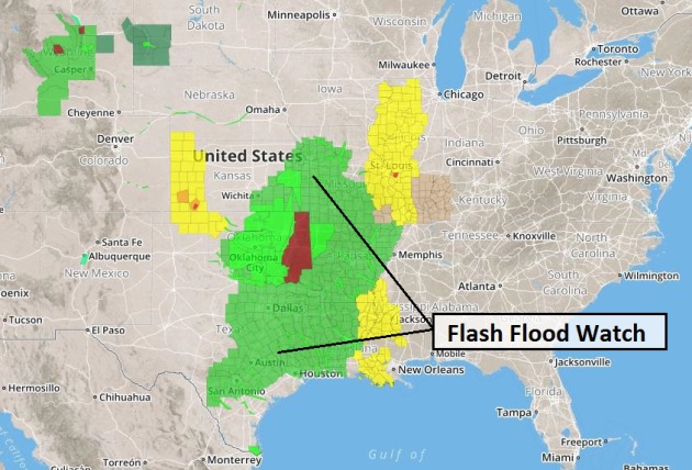
Flash Flood Potential. NOAA has issued a flood watch from San Antonio to Kansas City – a huge expanse of real estate threatened by sustained urban and river flooding. Texas and Oklahoma have been hit very hard by flooding; an active southern branch of the jet stream Exhibit A of a strengthening El Nino warming phase in the Pacific Ocean. Source: NOAA and AerisWeather.
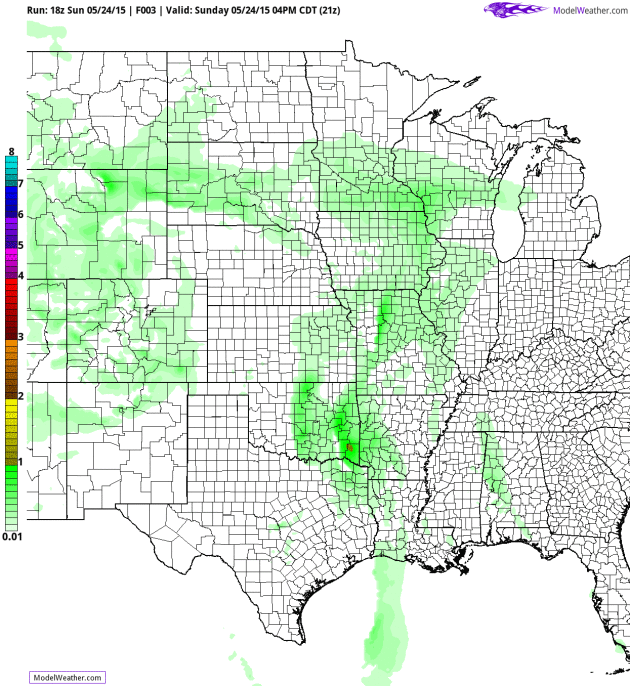
Moist Plume. NOAA’s 12 KM NAM model shows the surge of moisture responsible for extensive flooding over the Southern Plans. Minnesota is on the cool/stable side of a deep trough of low pressure, meaning little or no risk of severe storms today, but showers and T-storms may pack locally heavy rain. 84 hour accumulated rainfall product: AerisWeather.
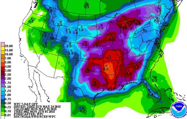
7-Day Rainfall Potential. QPF values suggest another 4-6″ of rain over the next week from near Dallas, Wichita Falls and Tulsa to Little Rock, Huntsville and Atlanta. Although the heaviest rainfall amounts are forecast to remain just south and east of Minnesota, another 1-2″ of rain is possible by early next week.
Storms Roughly Every 3 Days. Right now sloppy fronts and storms are spaced about 3 days apart, a trend which should continue into next week. The boundary separating steamy heat over the Plains from cool, comfortable Canadian air will continue to hover over the Upper Mississippi Valley the next 10 days, sparking more rounds of locally heavy rain. Source: Weatherspark.
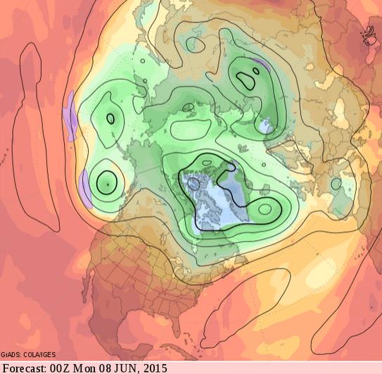
June Sizzle? Long-range GFS guidance shows the core of the jet stream lifting north as hot, steamy air expands northward across the Rockies and Plains. If this forecast verifies, still a big if, it may heat up into the 80s and 90s by mid-June. Source: GrADS:COLA/IGES.
According to the US National Oceanic and Atmospheric Administration (NOAA), May 2014 to April 2015 is the joint-warmest 12-month period in 136 years.
Those figures could rise further if the weather phenomenon known as El Nino continues to intensify, as scientists RTCC has spoken to believe it will.
– See more at: http://www.rtcc.org/2015/05/21/el-nino-likely-to-ensure-2015-breaks-warming-records/#sthash.ALmaQ1Uu.dpuf
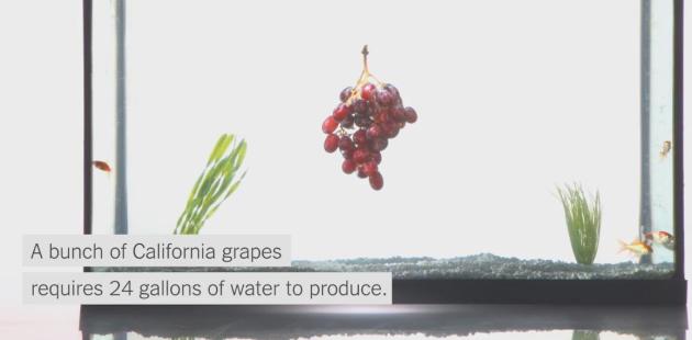
Your Contribution To The California Drought. Much of our food is grown in California – I remember reading that the average distance from where food is grown to where it’s consumed is about 1,000 miles. More incentive to buy (and eat) local, when possible. Here’s an excerpt from The New York Times: “…California farmers produce more than a third of the nation’s vegetables and two-thirds of its fruits and nuts. To do that, they use nearly 80 percent of all the water consumed in the state. It is the most stubborn part of the crisis: To fundamentally alter how much water the state uses, all Americans may have to give something up. The portions of foods shown here are grown in California and represent what average Americans, including non-Californians, eat in a week...”
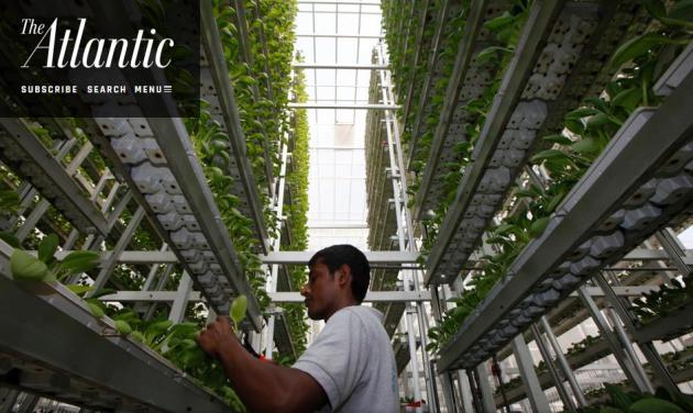
Farming In The Sky. The future of agriculture may be…up? Here’s an excerpt of a fascinating story at The Atlantic: “…The future of farming is looking up—literally, and in more ways than one: There are grow towers, rooftops, and industry talk of Waterworld-style “plant factories” in futuristic floating cities. And this vertical movement is happening for a variety of reasons. For one, by prioritizing localized operations, it offers a remedy to the mounting economic difficulties that independent farmers face when otherwise so easily underpriced by Big Ag. But more importantly, it’s rising out of environmental concerns—space, soil health, climate change, vital ecosystems decimated by monoculture…” (Photo: Edgar Su, Reuters).
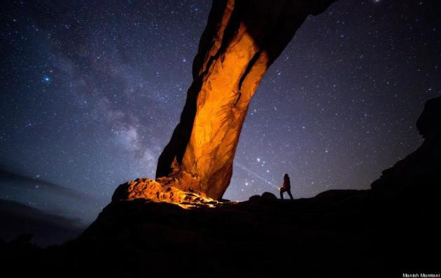
10 Jaw-Dropping Photos From The 2015 National Geographic Traveler Photo Contest. Here’s an excerpt from Huffington Post: “The entries for the 2015 National Geographic Traveler Photo Contest are in, and the photographs are as stunning as ever. The annual contest asks photographers from all around world to submit photos in four categories: Travel portraits, outdoor scenes, sense of place, and spontaneous moments. Photographers are allowed to submit as many photos as they’d like for $15 apiece, with no cap on the number one person can enter. The contest, which ends June 30, is still open for entries…”
Photo credit above: “I was out in the Arches National Park to take night pictures, but the clouds moved in. I waited for about two hours in the car and finally the sky cleared and I got this image.” Photograph and caption by Manish Mamtani/National Geographic Traveler Photo Contest.
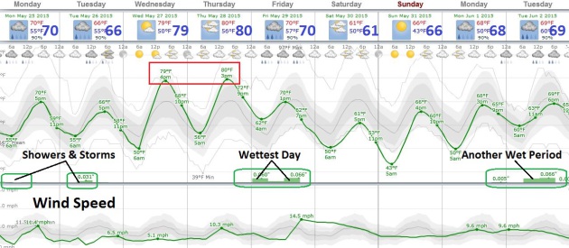
MEMORIAL DAY: A few showers and T-storms likely, damp most of the day. Winds: SW 15. High: 68
MONDAY NIGHT: Showers begin to taper. Low; 57
TUESDAY: Sunny start, PM T-storm possible, especially up north. High: 72
WEDNESDAY: More sun, feels like summer again. Wake-up: 59. High: 80
THURSDAY: Sticky sunshine, a taste of July. Dew point: 62. Wake-up: 62. High: 82
FRIDAY: Showers and T-storms likely. Wake-up: 60. High: 72
SATURDAY: Partly sunny, cooler, less humid. Wake-up: 53. High: 66
SUNDAY: Plenty of sun, quite pleasant. Wake-up: 47. High: near 70
Climate Stories…
Shell Boss Warns That Unchecked Fossil Fuel Burning Will Cause Global Warming. Could there arise new technologies even more disruptive than fracking, that allow us to burn fossil fuels without CO2 emissions? I wouldn’t rule anything out. Even though this appears like a remote technological miracle today, new processes and materials could make today’s (pipe-dream) a reality at some point in the future. That said, we can’t count on this kind of innovation; we may have to dial down fossil fuel use even faster to stay within a 2C temperature rise. Here’s an excerpt of a story at Christian Today: “The world’s fossil fuel reserves cannot be burned unless some way is found to capture their carbon emissions, Royal Dutch Shell Chief Executive Officer Ben van Beurden said on Friday. In an interview published in the Guardian newspaper, Van Beurden forecast that global energy use would produce “zero carbon” by the end of the century, and that his group would get a “very large segment” of its earnings from renewable power...”
