77 F. high in the Twin Cities Tuesday.
84 F. average high on July 8.
89 F. high on July 8, 2013.
-20 F. Temperatures by next Tuesday and Wednesday may be 15-20 degrees cooler than average for mid-July.
Weather Adventures
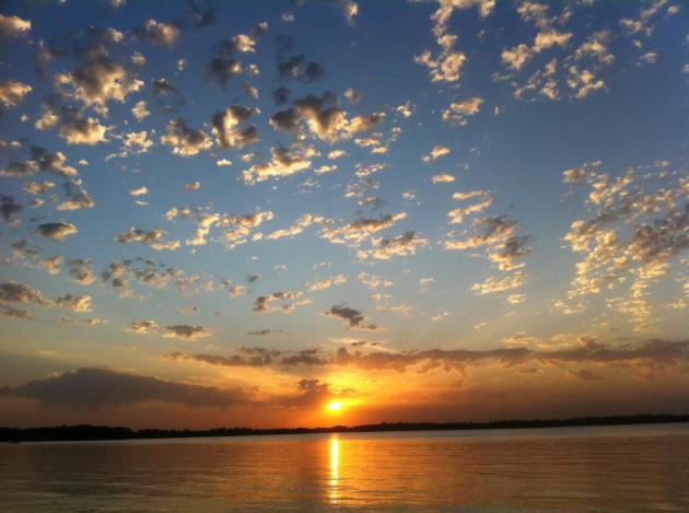
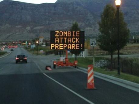
It’s all in your mind. If you tell yourself you’re miserable – chances are you will be. I prefer a glass-half-full approach. Yes, our weather is increasingly volatile. There are many days Mother Nature seems intent on murdering us in our sleep. But isn’t this fun!
Cue the crickets.
Kari Kennedy is a producer at TPT’s “Almanac” program. She’s been canoeing up north and has seen it all in 2014: a heat wave just days after ice-out, no June campfires because of monsoon rains, yet she’s heading back for more. “We only had pea-sized hail on our canoe trip so we managed OK!” It’s always an adventure to live here in Minnesota” she e-mailed me. That’s the right attitude to have living in The Superbowl of Weather, Land of 10,000 Weather Atrocities.
Nothing violent is brewing, although more T-storms flare up Friday, again Sunday PM hours. Saturday still looks like the better day of the weekend for outdoor fun.
We’re heading into what is historically the hottest 2 weeks of the year, so don’t take 70s for granted today. Next week’s cool frontal passage looks like something out of late September. Highs in the 60s by Tuesday & Wednesday?
Hey, it’s not a Canadian Smack. Think of this as free A/C. And a break from the bugs, I pray.
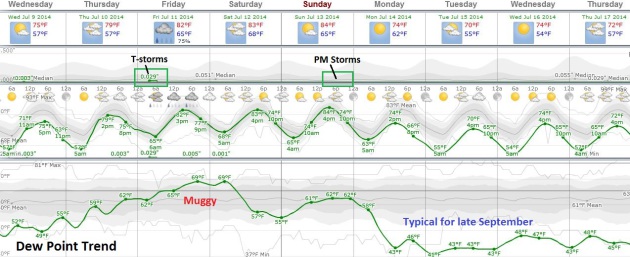
An Early Autumn? I should censor myself – of course there’s PLENTY of summer left, but next week we get a premature taste of late September. By midweek temperatures dip into the 50s, even some 40s outside the Twin Cities metro, with highs in the 60s to near 70 F. by Tuesday. But first we warm up into the 80s this weekend; the best chance of T-storms early Friday, again Sunday PM hours. Dew points peak in the mid to upper 60s this weekend before dropping off dramatically next week. Source: Weatherspark.
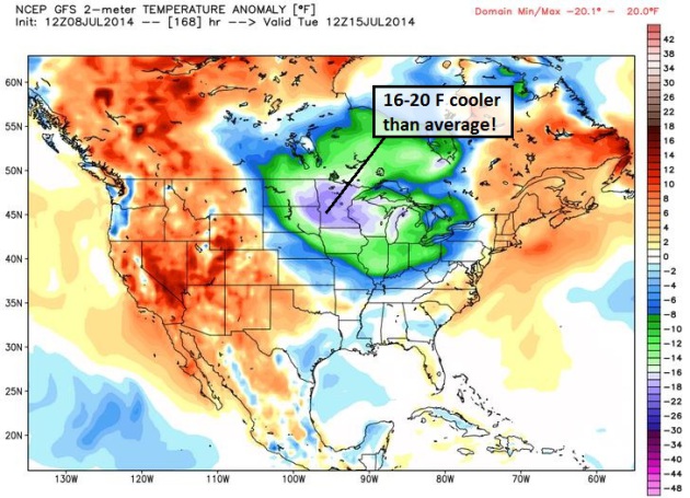
Temperature Departures. By next Tuesday morning at 12z temperature anomalies may be as much as 20 F. cooler than average for mid-July from the eastern Dakotas into western Wisconsin. Light jackets and sweatshirts during what is, historically, the hottest week of summer? The jet stream is still unusually erratic for mid summer. Source: Weather Bell.
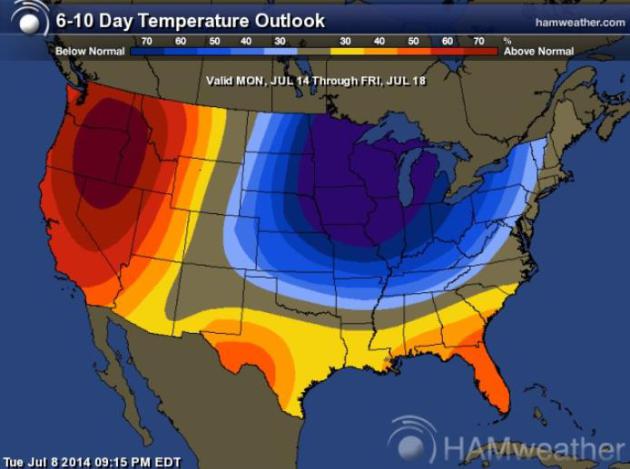
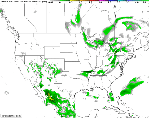
A July Polar Vortex. Why not? Nothing much surprises me any more. No wait, a raging blizzard in mid-July would shock me, otherwise I’m becoming numb to crazy extremes and climate volatility. NOAA CPC shows a huge temperature imbalance next week: record heat out west, with potentially record-setting chill from the Upper Mississippi Valley into the Great Lakes. Source: HAMweather.
Another Sloppy Warm Front. The squall line that produced wind damage across New York state and Pennsylvania yesterday (straight-line winds gusting over 70 mph in some towns) sails out into the Atlantic with clearing skies from the Great Lakes to New England. Meanwhile the next warm front pushes heavy T-storms across the Midwest Thursday night and Friday, setting the stage for low to mid 80s this weekend. Enjoy the warmth; a big cool-down arrives next week. 84 hour NAM Future Radar: NOAA and HAMweather.
Storm Chasers Fight Accusations of Bad Behavior as “Chasertainment” Comes of Age. As is often the case, a few bad apples make it harder on everyone else who is trying to be responsible and do the right thing. Here’s an excerpt from an interesting story at Examiner about the proliferation of storm chasing in the age of Twitter and increased competition to hit Media Gold: “…Well-respected storm chaser and research meteorologist Chuck Doswell wrote in his blog following the Pilger tragedy: “Storm chasing is being flooded with a large infusion of folks out there chasing that are, as my friend (deleted name) says, mostly about themselves and not so much about the storms. ‘Look at me!’ they shout. ‘I’m special because I chase storms [stupidly!].’ They thumb their noses at the very notion of chasers being responsible to others. They wallow in their uncaring “outlaw’’ status, joyful as a pig in a mud puddle when they get publicity for their “exploits…”
Why Hurricane Arthur is a Weather Forecaster’s Worst Nightmare. Models do a pretty good job with hurricane tracks, but predicting intensity at landfall is another challenge altogether. The nightmare scenario: a tropical storm or Category 1 hurricane that blows up into a Category 4 overnight, leaving little time for people to evacuate vulnerable barrier islands. Here’s an excerpt of a Mashable story from Andrew Freedman: “…Storms like this instill fear in the hearts of hurricane forecasters because they spotlight how — despite satellites, radars, “hurricane hunter” aircraft and their legion of dropsondes, and other technological wizardry — the puzzle of what makes such storms rapidly intensify remains a mystery. And more so in this case than in others, so does how to solve the challenge of communicating to the public what all of the implications of forecast uncertainty are…”
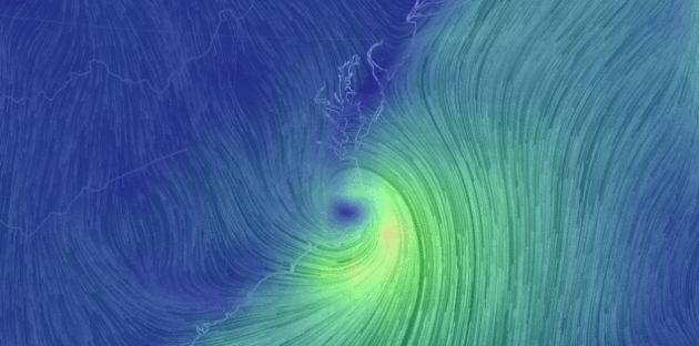
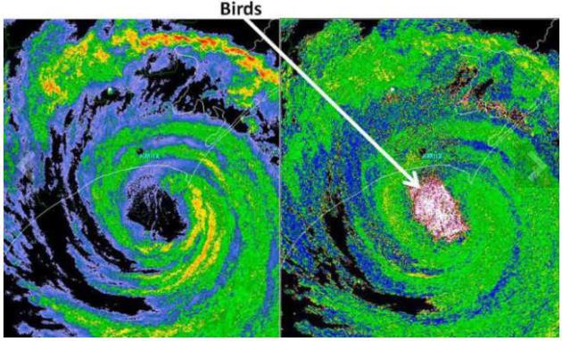
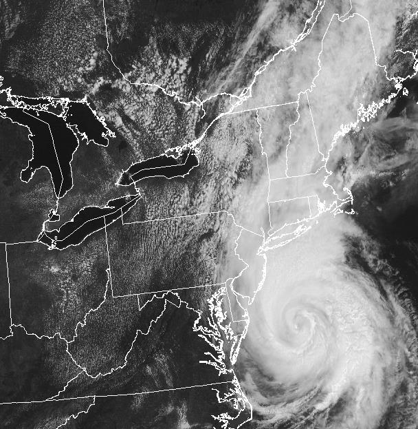
What Do Scientists Think Was Trapped In Hurricane Arthur Off The Carolina Coast? With Dual Polarization Doppler radar we’re seeing things we never saw before; here’s an excerpt of an interesting story at WSPA.com: “Scientists have captured images of Hurricane Arthur just off the NC coast that show what they believe is a huge flock of birds caught in the eye of the storm. The severe weather and radar research group at the University of Alabama at Huntsville has studied various radar images from last week’s storm. They also followed reports of birds appearing in odd places in the US after the storm…”
Image credit: “Radar of Arthur from National Weather Service.”

Bird Notes. Hurricane Arthur Brought Unusual Birds Up North Carolina Coast. Trapped in the relatively calm eye and then deposited over North Carolina – thousands of birds caught a free (and harrowing) ride from Arthur. Here’s a clip from MyrtleBeachOnline.com: “…While the passage of tropical storms or hurricanes often leaves unusual seabirds in their wake, such was not the case with the passage of Arthur in the Myrtle Beach area last week. However, a few miles up the coast at Wrightsville Beach, N.C., a Leach’s storm-petrel was serendipitously photographed and a sooty tern observed. Farther north, a magnificent frigatebird was observed at Beaufort, N.C., while a bridled tern was seen at Lake Mattamuskeet, N.C., a sooty tern at Nags Head, N.C., and a dead great shearwater at Topsail Beach, N.C...”
Photo credit above: “Painted buntings continue to visit feeders at Huntington Beach State Park’s Nature Center.” By Gary Phillips – for The Sun News.
Five Hazardous Weather Myths Debunked. AccuWeather has an interesting story, focusing on weather-related myths. Here’s an excerpt, answering the question: Is humid air heavier than dry air? “Dry air is actually heavier than humid air, AccuWeather.com Senior Meteorologist Steve Wistar said. There are more molecules of water in humid air which are lighter than molecules of air, he said. “You can really feel the presence of humid air, but it is less dense,” he said. An airliner will need a larger runway length in dry air because there is more air resistance, and a baseball will go farther in humid air...”
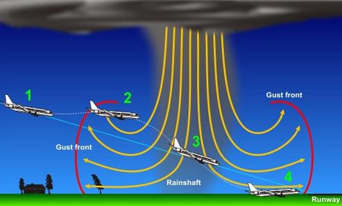
Defeating The Downburst: 20 Years Since The Last U.S. Commercial Jet Accident from Wind Shear. The threat of rapidly shifting winds in the vicinity of airport runways has been well documented for some time; new high-resolution Doppler capabilities and onboard radar can help pilots avoid the most dangerous forms of turbulence during take-off and approach. Here’s a clip of of a good explanation and perspective from meteorologist Mike Smith, writing for The Washington Post: “…Downburst-driven wind shear, for many years, was the leading cause of airline accidents. Not listed above was a near-miss involving Air Force One carrying President Reagan. A downburst occurred immediately after it landed at Andrews Air Force Base in August, 1983. The airfield anemometer (wind speed instrument) clocked a peak gust of 150 mph. That such a close call involving Air Force One could occur was evidence of the deep skepticism involving Dr. Fujita’s hypothesis…” (Image credit: NOAA).
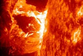
Who Turned Out The Lights? The Coming Mega Sun Storm. It’s usually the stuff you’re not expecting and not planning for that bites you in the butt, along with a “cascade of unintended consequences”. Bloomberg Businessweek takes a look at what an X-Class solar flare could do to the grid and communications; here’s an excerpt: “…A 2008 report published by the National Academy of Sciences drew attention to the risks. It cited Kappenman’s earlier work, which said a severe storm could disable hundreds of the U.S. grid’s high-voltage transformers, leaving more than 130 million people in the dark for months. The reinsurance industry has recently begun to raise concerns about the fallout from a major sun storm. A 2013 report by Lloyd’s of London warned that such an event could, among other things, disrupt financial markets, food supplies, transportation systems, and hospital services at an economic cost of as much as $2.6 trillion…”

During Natural Disasters, Hospitals Must Bounce Back, Health Officials Say. Resilience won’t be optional for most businesses, including first responders and hospitals. Here’s a clip from a story at jacksonville.com: “…Members of the American Meteorological Society, or AMS, have recently added their concerns about hospital resilience in the aftermath of “high-impact” weather events throughout the country. The meteorological society suggestions include having medical centers look at their structural designs and, in some cases, relocate critical components to higher ground. When Katrina left large stretches of low-lying New Orleans submerged for weeks, it demonstrated the importance of having facilities that remain functional and accessible…”

A Correction Is Coming. Predicting the future is challenging, from weather to world events to inevitable economic downturns. Here’s an excerpt from one of my favorite financial writers, Barry Ritholtz, at Bloomberg View: “…As we have detailed far too many times, people are terrible at making predictions. You draw conclusions from a single data point. You don’t know what the economy is going to do, or where interest rates are going. You can’t even forecast your own behavior. Forecasting the stock market is even harder. Yet people constantly try to time the market, pick the exact points to jump in and out. No one does this especially well, and that is before we consider costs and taxes...”
Photo credit: “That’s a lot of red.” Photographer: Dario Pignatelli – Bloomberg.

Welcome to the Everything Boom, or Maybe the Everything Bubble. Neil Irwin at The New York Times takes a look at how prices for nearly everything are going up; here’s a clip: “…Welcome to the Everything Boom — and, quite possibly, the Everything Bubble. Around the world, nearly every asset class is expensive by historical standards. Stocks and bonds; emerging markets and advanced economies; urban office towers and Iowa farmland; you name it, and it is trading at prices that are high by historical standards relative to fundamentals. The inverse of that is relatively low returns for investors…”
Photo credit above: Richard Drew/Associated Press.

Uber’s Brilliant Strategy to Make Itself Too Big To Ban. Wired has a fascinating look at how Uber may be following the Amazon model: be not afraid to lose money in the short term if you can gain market share quickly; here’s a clip: “…Consider Uber’s kinship with Amazon. The comparison isn’t obvious at first, since Uber doesn’t sell goods, just a service. But their stories are similar. A startup led by a brash, charismatic CEO catches a creaky old industry unaware. It grows quickly, and its popularity explodes as its brand becomes nearly synonymous with the disruptive service it’s offering. Amazon grew—and is still growing— because it’s not afraid to lose money. Low prices and free shipping deals eat away at profitability, but they also keep customers coming back…” (Image credit: Uber).

For Taylor Swift, The Future of Music is a Love Story. You don’t have to love Taylor Swift’s music to appreciate her take on the industry she adores, and some of the jaw-dropping trends in recent years. It’s harder than ever to be a working musician, without having that part-time barista gig. Here’s an excerpt from an interesting Wall Street Journal article: “..Music is art, and art is important and rare. Important, rare things are valuable. Valuable things should be paid for. It’s my opinion that music should not be free, and my prediction is that individual artists and their labels will someday decide what an album’s price point is. I hope they don’t underestimate themselves or undervalue their art...”
TODAY: Comfortable sunshine. Dew point: 53. Winds: NW 10. High: 77
WEDNESDAY NIGHT: Mostly clear and cool. Low: 59
THURSDAY: Clouds increase, T-storms at night. High: 81
FRIDAY: Few T-storms, some heavy. Wake-up: 65. High: near 80
SATURDAY: Partly sunny, the nicer day. Wake-up: 68. High: 83
SUNDAY: Early sun. PM Showers, T-storms. Wake-up: 67. High: 82
MONDAY: Mix of clouds and sun, much cooler. Wake-up: 57. High: 74
TUESDAY: Sunny and cool. Who turned off the heat?. Wake-up: 55. High: 70
Climate Stories…
Changing Antarctic Winds Could Accelerate Sea Level Rise. We don’t know what we don’t know, but the scientific method is shedding new light on how complex systems, like Antarctic ice, react with increasingly warm water (and changing wind currents aloft). Here’s an excerpt from Science 2.0: “Changes to Antarctic winds have been implicated in southern Australia’s drying climate but a new estimate says they may also have a profound impact on warming ocean temperatures under the ice shelves along the coastline of West and East Antarctic. Projected changes in the winds circling the Antarctic may accelerate global sea level rise significantly more than previously believed. Most sea level rise studies focused on the rate of ice shelf melting due to the general warming of the ocean over large areas…”


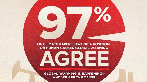
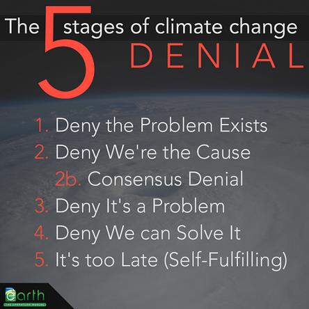
How To Convince a Republican: Use a Pie Chart! If only it were that simple. Here’s a clip from a story at Mother Jones: “…The strategy has its critics, including Yale science communication researcher Dan Kahan, who contends that the approach will backfire among conservative ideologues. A new study just out in the journal Climatic Change, however, suggests not only that the “97 percent consensus” message can be effective, but that it will work best when expressed in the form of a simple phrase or (eat your heart out, USA Today) a pie chart. Like this one, which is an actual image designed to spread the “97 percent” message…”
Image credit above: SkepticalScience.com
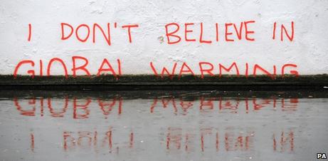
Global Warming Skeptics Seek Own Documentary, 8 Years after “Inconvenient Truth”. It’s prudent to be skeptical (about everything), but heavily financed, manufactured doubt? Here’s an excerpt of an Andrew Freedman article at Mashable: “Eight years after Al Gore’s Academy Award-winning climate-science documentary, An Inconvenient Truth, a prominent climate-skeptic group announced a crowdfunding initiative on Tuesday to produce a documentary that will provide their perspective on the issue. Of course, nearly the entire climate-science community disagrees with this perspective. The Committee for a Constructive Tomorrow (CFACT), a conservative group, announced its filmmaking endeavor in Las Vegas at an annual meeting of global-warming skeptics, which is being hosted by libertarian group The Heartland Institute. The conference began Monday, and ends on Wednesday…”
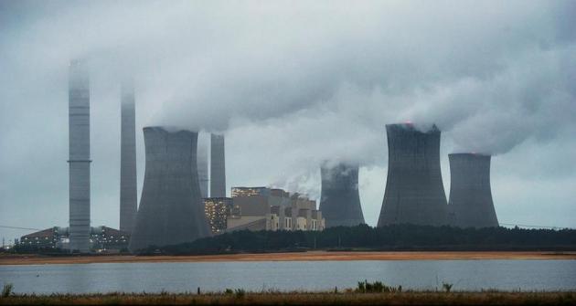
Photo credit above: “The coal-fired Plant Scherer is shown in operation early Sunday, June 1, 2014, in Juliette, Georgia.” Image: John Amis/Associated Press.
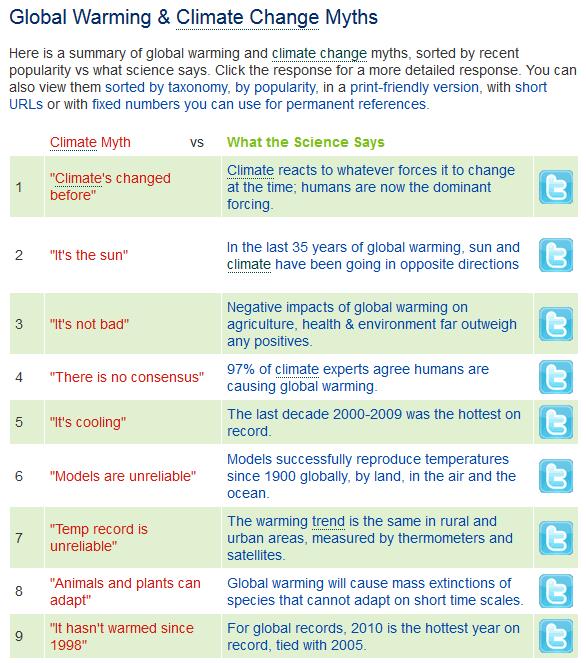
Most Popular Climate Denial “Arguments”. For the complete list and details click over to Skeptical Science.
