75 F. high in the Twin Cities Wednesday.
79 F. average high on August 26.
76 F. high on August 26, 2014.
August 26, 1915: Severe cold and killing frosts across Minnesota with 23 degrees at Roseau.
Erika Is No Lady
Beware of the Caribbean in late August and September. There’s a reason why hotel rooms and cruises are slightly discounted: hurricane season peaks in the coming weeks.
September 10 is the date when a hurricane landfall is most likely, statistically, here in the U.S. – corresponding to peak ocean water temperatures. Hurricanes derive their energy from warm ocean water; the warmer the water the greater the potential for intensification.
In recent weeks wind shear, dry air aloft and Saharan dust has kept a lid on the tropics – at the same time we’ve seen a parade of Category 5 super-typhoons in the western Pacific – but that’s changing. The latest model consensus brings a weak, Category 1 Hurricane Erika near Florida by next Monday. Uncertainty is high regarding track and intensity; the ECMWF curves the storm closer to the Carolinas.
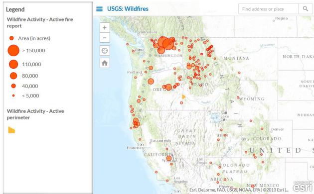
Smoke from Washington wildfires left yesterday’s sky an eerie shade of dirty-blue. Clouds increase today; heavy showers and T-storms slosh across southern Minnesota Friday with locally heavy rainfall possible. The sun should be out this weekend and daytime highs flirt with 90F from Sunday into much of next week.
NOAA’s GFS model was right 2 weeks ago, hinting at a late-summer hot spell. Don’t pack away the short shorts just yet.
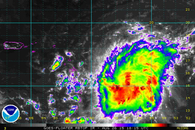
* Enhanced IR satellite loop of “Erika” courtesy of NOAA.
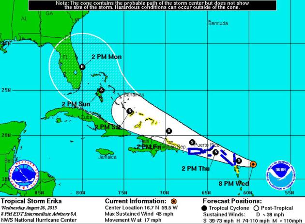
Official NHC Forecast. As of Wednesday evening here is the projected path, along with the “cone of uncertainty”. There’s a fair amount of uncertainty with Erika, but there’s little question the east coast of Florida may be threatened by Monday of next week. From there things may get very interesting/precarious for the southeast coastline of the USA. Source: NOAA NHC.
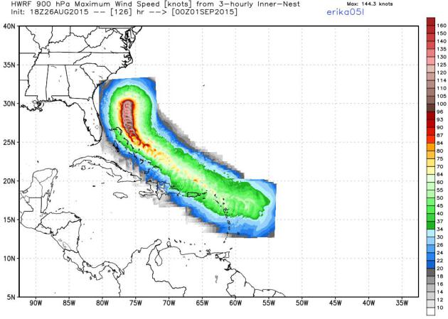
NOAA HWRF Model. Here is the latest projected path of Erika from NOAA’s high-resolution hurricane model, the HWRF, which keeps the core of strongest winds and heaviest rains well offshore. Source: WeatherBell.
GFS Model. NOAA’s GFS model brings a strengthening Hurricane Erika into Florida by late Monday, with further strengthening projected as the storm tracks along the Georgia and Carolina coast early next week, doing one big loop just offshore. It may be a very close call for Miami, Vero Beach, Jacksonville, Savannah, Charleston and the Outer Banks of North Carolina.
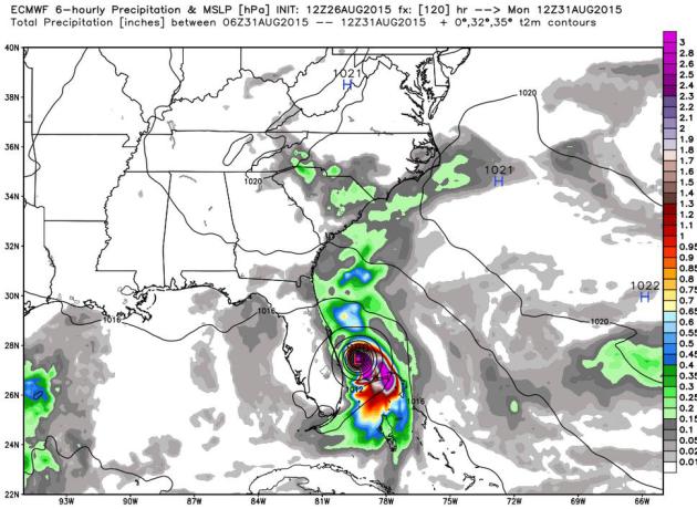
ECMWF: Monday Morning. The European model, which often does a better job with tropical systems (Sandy comes to mind as the most prominent example) pulls a small, compact, rapidly strengthening Hurricane Erika very close to the east coast of Florida by Monday morning.
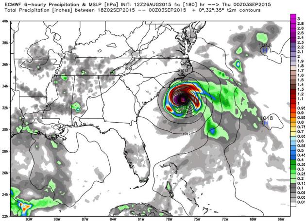
ECMWF: Wednesday Evening. The same model predicts additional strengthening over the warm waters of the Gulf Stream, with the storm remaining just off the coast of the Carolinas. A bit close for comfort. It’s too early to project any potential landfall with a high degree of confidence; interests from Florida to the Outer Banks will want to keep a very close eye on Erika’s progress in the days to come. The forecast will change.
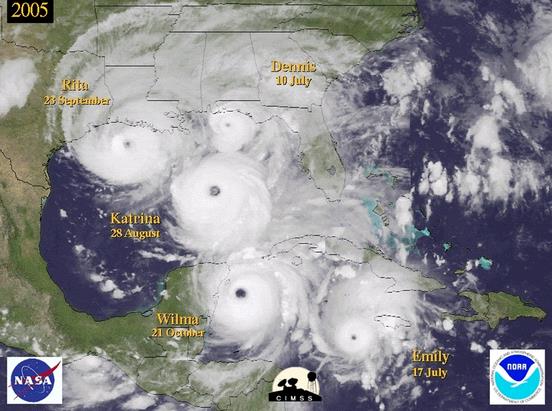
U.S. Coastline Vulnerability Is Growing To Unprecedented Levels. A decade-long hurricane drought is breeding apathy; at some point the bubble will burst and we’ll experience another year like 2005. Here’s an excerpt of a Washington Post explainer: “…The stark reality is coastal communities are living on borrowed time, and to adapt a quote from a well-known Hollywood movie, are seemingly writing checks their collective municipalities cannot cash. How rare is the current 10-year “drought”? The results of a 2015 statistical study by Timothy Hall of the NASA Goddard Institute for Space Studies indicated a nine-year hiatus in major hurricane landfall along the U.S. coastline would be expected to occur once every 177 years...”
Graphic credit above: “Montage of several 2005 hurricanes.” (CIMSS)
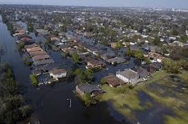
Flood Damage After Katrina Could Have Been Prevented, S&T Expert Says. Hindsight is always 20/20 but hubris and overconfidence often has tragic consequences. Here’s an excerpt from Missouri S&T News and Events: “…The journal article focuses on the U. S. Army Corps of Engineers and its lack of external peer reviews that allowed for faulty flood walls to be installed in the city. It pinpoints the key factors that led to the walls’ failure and the actions taken years before the disaster that allowed the engineering oversights to occur. “As more information has emerged from the time of the disaster and its prior decision-making processes, new details allow us to have a better idea of the situation and what led to the various levee failures,” says Rogers. “This article is meant to put the record straight about the conclusions people drew from the disaster, many of which were based on incorrect information...”
10 Years After Katrina Louisiana Is Becoming a Model for Climate Resilience. Huffington Post has the story; here’s the intro: “A decade after Hurricane Katrina devastated coastal Louisiana, forcing 1.5 million residents to evacuate and causing $100 billion in damage, the region is becoming a model for climate change adaptation planning — even if some people in the state still don’t want to say the “c” word. Louisiana’s governor, long-shot Republican presidential candidate Bobby Jindal, has been non-committal on climate change. He’ll acknowledge it’s happening, but says he’s uncertain how much humans are to blame. Nevertheless, Louisiana officials have been planning for rising temperatures and the cascading impacts climate change will have on the state, from rising seas to potentially more dangerous storms…”
Photo credit above: . “This Nov. 26, 2012, photo shows a flood wall and floodgate along Lakeshore Drive and Lake Pontchartrain in New Orleans.”
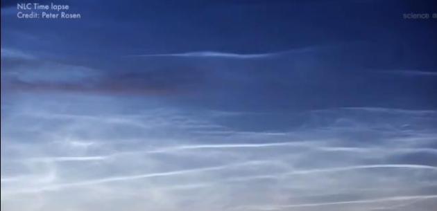
Are More Sightings of Noctilucent Clouds a Harbinger of Warming? This isn’t the first time I’ve heard this; AOL.com has an update; here’s the intro: “Blue clouds are becoming more common in certain areas, and scientists are wondering if it could be a sign of global warming. Noctilucent clouds or NLCs, which glow blue, have been appearing at more southerly latitudes, with sightings as far down as Northern California. Computer models suggest that as greenhouses gasses warm the lower levels in the atmosphere, the upper layers cool. That scenario is conducive to these high clouds forming…” (Credit: Peter Rosen).
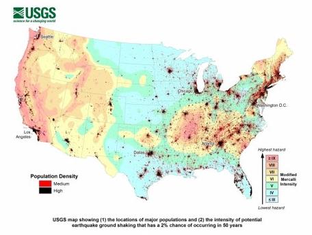
Half of U.S. Could Be Harmed by Earthquakes. Here’s the intro to a sobering report on new USGS research from sfgate.com: “Half the United States population is at risk of being harmed by earthquakes, and tens of millions are in the bull’s-eye of much stronger earthquakes. That’s the grim outlook of a U.S. Geological Survey report published earlier this month that focused on answering the great and terrible question: How devastating can earthquakes actually be to Americans and what should we do about it? The report states matter-of-factly:
More than 143 million Americans living in the 48 contiguous states are exposed to potentially damaging ground shaking from earthquakes. When the people living in the earthquake-prone areas of Alaska, Hawaii and U.S. territories are added, this number rises to nearly half of all Americans.
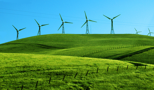
Wind Power Must Now Contend With Extreme Weather. More volatility in weather means more variance in average wind speeds; as reported by ClimateWire and Scientific American: “…California, Washington, Oregon and Texas, hotbeds for wind farms, had a particularly slow winter. Some regions saw winds around 50 percent lower than normal. Since then, conditions have started improving into early summer but have remained largely below average for most regions in the West, according to Vaisala. Lower winds mean turbines have been churning out less electricity. A U.S. Energy Information Administration analysis confirmed that wind farms in California, Oregon and Washington had been working at a reduced rate this spring compared with the five-year mean...”

How Accurate Is The Farmer’s Almanac Winter Forecast? Take any (weather) prediction beyond 2 weeks with a monstrous grain of salt; here’s an excerpt from TIME: “…In 2007, Penn State meteorologist Paul Knight penned a damning examination of Almanac predictions. His view reflects that of much of the meteorological community—while forecasts are central to weather prediction, the chance of being accurate so far in advance is “zero,” he said. One major point of contention between meteorologists and the Almanac is the El Niño weather pattern, which the meteorological community says is getting stronger but the Almanac says is getting weaker…”
SATURDAY: Partly sunny, still comfortable. Wake-up: 59. High: 80
SUNDAY: Hot sun, hints of July. Dew point: 67. Wake-up: 65. High: near 90
MONDAY: Hazy sun, sticky again. Wake-up: 68. High: 91
TUESDAY: Intervals of sun, humid. Dew point: 68. Wake-up: 69. High: 90
WEDNESDAY: Dog Days of September, stuffy. Wake-up: 70. High: 91
Climate Stories…
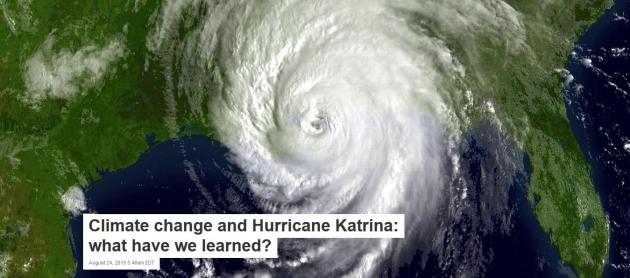
Climate Change and Hurricane Katrina: What Have We Learned? Here’s an excerpt of a story at The Conversation, written by MIT Professor of Atmospheric Science, Kerry Emanuel: “…An obvious point is that slowly rising sea levels increase the probability of storm-induced surges even when the statistics of the storms, such as top wind speed, themselves remain stable. Storm surges are physically the same thing as tsunamis but driven by wind and atmospheric pressure rather than the shaking seafloor, and they typically arrive near the peak of the storm’s fury. As with Katrina and Sandy, they are often the most destructive aspects of hurricanes. Had Sandy struck New York a century ago, there would have been substantially less flooding, as sea level was then roughly a foot lower. As sea level increases at an accelerating pace, we can expect more devastating coastal flooding from storms...”
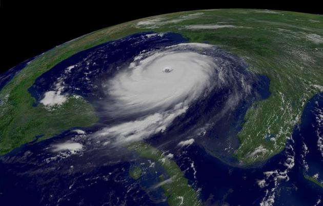
Hurricane Katrina Showed What “Adapting to Climate Change” Looks Like. Here’s a clip from a Dave Roberts story at Vox: “…First is the fact that people are extremely bad at envisioning inclement circumstances they haven’t experienced or witnessed. We are generally familiar with natural disasters as rare and extraordinary one-offs. This leads people intuitively to underplay both the severity of the damages climate change threatens and the effort and expense required to prepare for them. In fact, if climate change remains unchecked, there will be multiple simultaneous disasters: heat waves, droughts in key agricultural areas, rising sea levels and more frequent floods, food shortages, resource conflicts, and mass migrations…” (Image: NOAA, NASA).
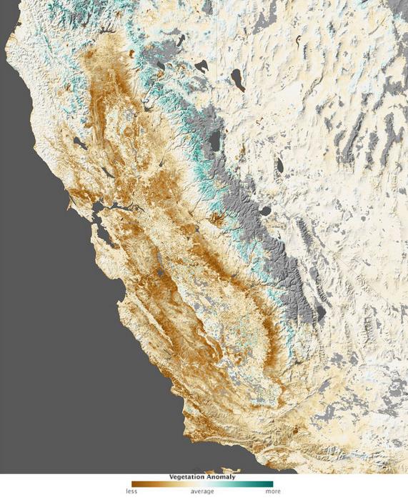
Yes, Climate Change Has a Hand In The California Drought. Here’s a clip from an Ars Techinca story that jumped out: “…In the end, the researchers calculated that anthropogenic global warming was responsible for 8 to 27 percent of the extremity of the drought between 2012 and 2014, with the dearth of rainfall chipping in around 70 percent. Because of the way they estimated anthropogenic impacts, the researchers say these numbers are conservative estimates. If you think in terms of the probability of a drought this extreme taking place, the anthropogenic contribution is enough to make it about twice as likely. The researchers write that “this analysis illustrates the general fact that the anthropogenic drying trend, while still small relative to the range of natural climate variability, has caused previously improbable drought extremes to become substantially more likely...”
Image credit above: “Vegetation was pretty sparse in early 2014.” NASA Earth Observatory
